ad blue Acura TL 2010 Navigation Manual
[x] Cancel search | Manufacturer: ACURA, Model Year: 2010, Model line: TL, Model: Acura TL 2010Pages: 174, PDF Size: 15.4 MB
Page 149 of 174

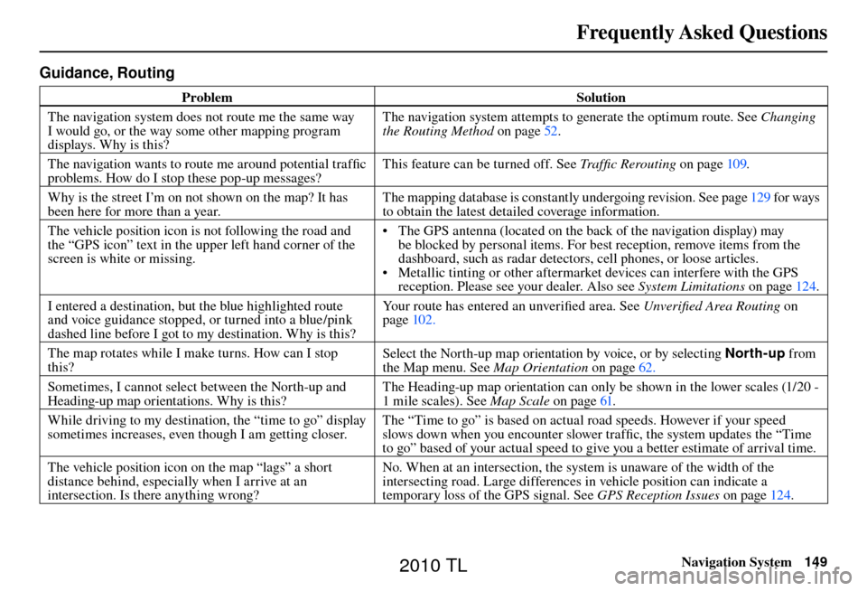
Frequently Asked Questions
Navigation System149
Guidance, Routing
Problem Solution
The navigation system does not route me the same way
I would go, or the way some other mapping program
displays. Why is this? The navigation system attempts to generate the optimum route. See
Changing
the Routing Method o n p a g e 5 2 .
The navigation wants to route me around potential traffi c
problems. How do I stop these pop-up messages? This feature can be turned off. See
Traffi c Rerouting on page 109 .
Why is the street I’m on not shown on the map? It has
been here for more than a year. The mapping database is constantly undergoing revision. See page
129 for ways
to obtain the latest detailed coverage information.
The vehicle position icon is not following the road and
the “GPS icon” text in the upper left hand corner of the
screen is white or missing. • The GPS antenna (located on the back of the navigation display) may
be blocked by personal items. For best reception, remove items from the
dashboard, such as radar detectors, cell phones, or loose articles.
• Metallic tinting or other aftermarket devices can interfere with the GPS reception. Please see your dealer. Also see System Limitations on page 124 .
I entered a destination, but the blue highlighted route
and voice guidance stopped, or turned into a blue/pink
dashed line before I got to my destination. Why is this? Your route has entered an unverifi
ed area. See Unverifi ed Area Routing on
page 102 .
The map rotates while I make turns. How can I stop
this? Select the North-up map orientation by voice, or by selecting
North-up from
the Map menu. See Map Orientation on page 62 .
Sometimes, I cannot select between the North-up and
Heading-up map orientations. Why is this? The Heading-up map orientation can only be shown in the lower scales (1/20 -
1 mile scales). See
Map Scale on page 61 .
While driving to my destination, the “time to go” display
sometimes increases, even though I am getting closer. The “Time to go” is based on actual road speeds. However if your speed
slows down when you encounter slower traffi
c, the system updates the “Time
to go” based of your actual speed to give you a better estimate of arrival time.
The vehicle position icon on the map “lags” a short
distance behind, especially when I arrive at an
intersection. Is there anything wrong? No. When at an intersection, the system is unaware of the width of the
intersecting road. Large differences in vehicle position can indicate a
temporary loss of the GPS signal. See
GPS Reception Issues on page 124 .
2010 TL
Page 155 of 174

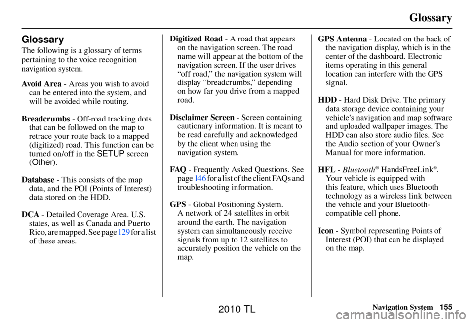
Glossary
Navigation System155
Glossary
The following is a glossary of terms
pertaining to the voice recognition
navigation system.
Avo i d A r e a - Areas you wish to avoid
can be entered into the system, and
will be avoided while routing.
Breadcrumbs - Off-road tracking dots
that can be followed on the map to
retrace your route back to a mapped
(digitized) road. This function can be
turned on/off in the SETUP screen
( Other ).
Database - This consists of the map data, and the POI (Points of Interest)
data stored on the HDD.
DCA - Detailed Coverage Area. U.S.
states, as well as Canada and Puerto
Rico, are mapped. See page 129 for a list
of these areas. Digitized Road
- A road that appears
on the navigation screen. The road
name will appear at the bottom of the
navigation screen. If the user drives
“off road,” the navigation system will
display “breadcrumbs,” depending
on how far you drive from a mapped
road.
Disclaimer Screen - Screen containing
cautionary information. It is meant to
be read carefully and acknowledged
by the client when using the
navigation system.
FAQ - Frequently Asked Questions. See
page 146 for a list of the client FAQs and
troubleshooting information.
GPS - Global Positioning System.
A network of 24 satellites in orbit
around the earth. The navigation
system can simultaneously receive
signals from up to 12 satellites to
accurately position the vehicle on the
map. GPS Antenna - Located on the back of
the navigation display, which is in the
center of the dashboard. Electronic
items operating in this general
location can interfere with the GPS
signal.
HDD - Hard Disk Drive. The primary
data storage device containing your
vehicle’s navigation and map software
and uploaded wallpaper images. The
HDD can also store audio fi les. See
the Audio section of your Owner’s
Manual for more information.
HFL - Bluetooth
® HandsFreeLink®.
Your vehicle is equipped with
this feature, which uses Bluetooth
technology as a wireless link between
the vehicle and your Bluetooth-
compatible cell phone.
Icon - Symbol representing Points of
Interest (POI) that can be displayed
on the map.
2010 TL
Page 164 of 174

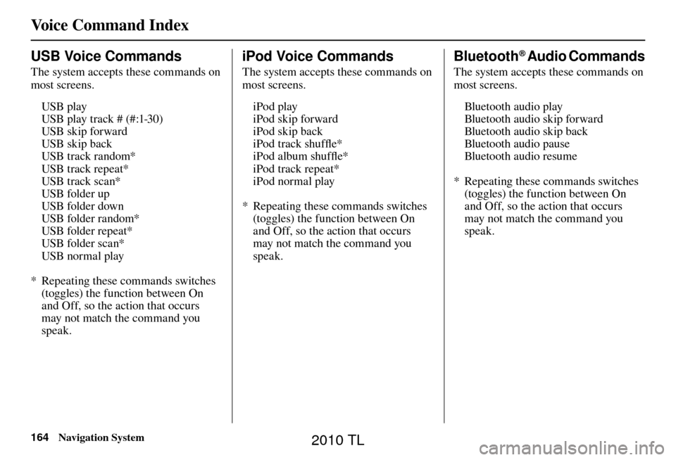
Voice Command Index
164 Navigation System
USB Voice Commands
The system accepts these commands on
most screens.
USB play
USB play track # (#:1-30)
USB skip forward
USB skip back
USB track random*
USB track repeat*
USB track scan*
USB folder up
USB folder down
USB folder random*
USB folder repeat*
USB folder scan*
USB normal play
* Repeating these commands switches (toggles) the function between On
and Off, so the action that occurs
may not match the command you
speak.
iPod Voice Commands
The system accepts these commands on
most screens.
iPod play
iPod skip forward
iPod skip back
iPod track shuffl e*
iPod album shuffl e*
iPod track repeat*
iPod normal play
* Repeating these commands switches (toggles) the function between On
and Off, so the action that occurs
may not match the command you
speak.
Bluetooth® Audio Commands
The system accepts these commands on
most screens.
Bluetooth audio play
Bluetooth audio skip forward
Bluetooth audio skip back
Bluetooth audio pause
Bluetooth audio resume
* Repeating these commands switches (toggles) the function between On
and Off, so the action that occurs
may not match the command you
speak.
2010 TL
Page 170 of 174

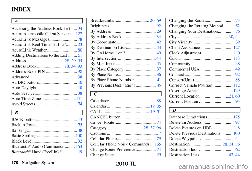
INDEX
170 Navigation System
A
Accessing the Address Book List ...... 94
Acura Automobile Client Service ... 127
AcuraLink Messages ......................... 78
AcuraLink Real-Time Traffi c
™..........23
AcuraLink Weather ........................... 80
Adding Destinations to the List ........ 51
Address ..................................28, 29, 95
Address Book ........................ 28, 34, 93
Address Book PIN ............................ 98
Advanced .......................................... 38
AUDIO button ................................... 10
Auto Daylight ...................................110
Auto Service ...................................... 38
Auto Time Zone ............................... 111
Avoid Streets ..................................... 74
B
BACK button ..................................... 13
Back to Route .................................... 75
Banking ............................................. 38
Basic Settings .................................. 100
Black Level ........................................ 92
Bluetooth
® Audio Commands ......... 164
Bluetooth® HandsFreeLink® ............. 19Breadcrumbs ...............................
20, 69
Brightness.......................................... 92
By Address ........................................ 29
By Address Book .............................. 34
By Coordinate ................................... 42
By Destination Lists .......................... 43
By Go Home 1 or 2 ........................... 49
By Intersection .................................. 44
By Map Input .................................... 45
By Place Category ............................. 37
By Place Name .................................. 36
By Place Phone Number ................... 41
By Previous Destinations .................. 35
C
Calculator .......................................... 88
Calendar ....................................... 19, 85
CALL ........................................... 19, 51
CANCEL button ............................... 11
Cancel Route ..................................... 74
Category .................................28, 37, 96
Cautions .............................................. 7
Cellular Phone ................................... 79
Cellular Phone Voice Commands ... 165
Change Route Preference .................. 74
Change State ..................................... 29Changing the Route ...........................
73
Changing the Routing Method .......... 52
Changing Your Destination ............... 76
City .............................................. 30, 44
City Vicinity ...................................... 39
Client Assistance ............................. 127
Clock Adjustment ............................. 110
Color ................................................. 113
Community ....................................... 38
Continental USA ............................... 49
Contrast ............................................. 92
Convert(Unit) .................................... 88
Correct Vehicle Position ...................112
Coverage Areas ............................... 129
Current Location ..........................21, 60
Current Position ................................ 95
D
Database Limitations ...................... 125
Delete an Address ............................. 97
Delete Pictures on HDD ................... 118
Delete Previous Destinations .......... 100
Delete Waypoints .............................. 44
Destination ............................. 28, 51, 76
Destination Icon ................................ 62
Destination Lists ......................... 43, 44
2010 TL