belt Acura RDX 2011 Navigation Manual
[x] Cancel search | Manufacturer: ACURA, Model Year: 2011, Model line: RDX, Model: Acura RDX 2011Pages: 176, PDF Size: 4.42 MB
Page 113 of 176

112Navigation System
System Setup
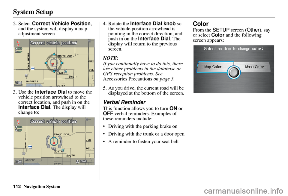
2. Select Correct Vehicle Position ,
and the system will display a map
adjustment screen.
3. Use the Interface Dial to move the
vehicle position arrowhead to the
correct location, an d push in on the
Interface Dial . The display will
change to: 4. Rotate the
Interface Dial knob so
the vehicle position arrowhead is
pointing in the correct direction, and
push in on the Interface Dial . The
display will return to the previous
screen.
NOTE:
If you continually have to do this, there
are either problems in the database or
GPS reception problems. See
Accessories Precautions on page 5.
5. As you drive, the current road will be displayed at the bottom of the screen.
Verbal Reminder
This function allows you to turn ON or
OFF verbal reminders. Examples of
these reminders include:
• Driving with the parking brake on
• Driving with the trunk or a door open
• A reminder to fasten your seat belt
Color
From the SETUP screen ( Other), say
or select Color and the following
screen appears:
Page 142 of 176

Navigation System141
Coverage Areas
CANADA CONNECTOR ROADS
The Cross-Canada Connector Road
allows for travel between the
provinces of British Columbia and
Quebec in DCA 11. Major
metropolitan city POIs are also
included.
Road Inclusion
Roads in the province of British
Columbia
Hwy-1/Trans Canada Hwy from Alberta/BC boundary to Vancouver
detailed city
Hwy-3/Crowsnest Hwy from Hwy-1/ Trans Canada Hwy (Hope) to Hwy-
5/Coquihalla Hwy (Hope)
Hwy-5/Coquihalla Hwy (in Hope) to Hwy-1/Trans Canada Hwy (in
Kamloops)
Hwy-99 between Vancouver and Whistler Roads in the province of Alberta
Hwy-1/Trans Canada Hwy across whole province
Hwy-1A from Cochrane to Canmore
Hwy-1X from Hwy-1A to Hwy-1/ Trans Canada Hwy
Morley Road from Hwy-1/Trans Canada Hwy
Hwy-3/Crowsnest Hwy (at Medicine Hat) to Lethbridge
Hwy-4 (at Lethbridge) to 1-15 (U.S. border)
Hwy-36 between Hwy-3 (in Taber) and Hwy-4 (in Warner)
Hwy-3/Crowsnest Hwy (in Lethbridge) to Hwy-2 (in Fort
Macleod)
Hwy-2 (in Fort Macleod) to Hwy-1/ Trans Canada Hwy (in Calgary)
Roads in the province of Saskatchewan Hwy-1/Trans Canada Hwy across whole province Roads in the province of Manitoba
Hwy-1/Trans Canada Hwy across whole province
Hwy-100/Trans Canada Hwy in Winnipeg (partial beltway)
Hwy-75 from Hwy-100/Trans Canada Hwy (Winnipeg) south to
link with 1-29 (U.S. border)
Roads in the province of Ontario Hwy-69/Trans Canada Hwy from Muskoka district to Sudbury
Hwy-17/Trans Canada Hwy from Ottawa Detailed Area Coverage to
Manitoba border
Hwy-17B at Sault Ste Marie to link with 1-75 (U.S. border)
Hwy-61 from Hwy-17 at Thunder Bay to link with US-61 (U.S.
border)
Hwy-11 from Muskoka district to North Bay
Hwy-60 and Hwy-127 in Nipissing County