navigation system BMW 3 SERIES 2003 E46 Mk3 Navigation System Manual
[x] Cancel search | Manufacturer: BMW, Model Year: 2003, Model line: 3 SERIES, Model: BMW 3 SERIES 2003 E46Pages: 17, PDF Size: 1.33 MB
Page 1 of 17
Initial Print Date:10/03/00Revision Date:10/24/00
Subject Page
Purpose of the System. . . . . . . . . . . . . . . . . . . . . . . . . . . . . . . . . . . . . . .3
System Components
Navigation Computer. . . . . . . . . . . . . . . . . . . . . . . . . . . . . . . . . . . . . 4
GPS Receiver. . . . . . . . . . . . . . . . . . . . . . . . . . . . . . . . . . . . . . . . . . . 5
Gyro Sensor. . . . . . . . . . . . . . . . . . . . . . . . . . . . . . . . . . . . . . . . . . . . 5
GPS Antenna. . . . . . . . . . . . . . . . . . . . . . . . . . . . . . . . . . . . . . . . . . . 6
Display Units. . . . . . . . . . . . . . . . . . . . . . . . . . . . . . . . . . . . . . . . . . . 6
Information/Body Bus Interface. . . . . . . . . . . . . . . . . . . . . . . . . . . . . . 7
Video/Audio Signals. . . . . . . . . . . . . . . . . . . . . . . . . . . . . . . . . . . . . . 8
Speed Signals. . . . . . . . . . . . . . . . . . . . . . . . . . . . . . . . . . . . . . . . . . 9
Reverse Gear input.. . . . . . . . . . . . . . . . . . . . . . . . . . . . . . . . . . . . . . 9
Principle of operation. . . . . . . . . . . . . . . . . . . . . . . . . . . . . . . . . . . . . . . 10
Workshop Hints. . . . . . . . . . . . . . . . . . . . . . . . . . . . . . . . . . . . . . . . . . . 12
Review Questions. . . . . . . . . . . . . . . . . . . . . . . . . . . . . . . . . . . . . . . . . 17
Table of Contents
Mk-3 NAVIGATION SYSTEM
Page 2 of 17
2
Mk-3 Navigation
Mk-3 NAVIGATION SYSTEM
Models: E38, E39, E46, E52, E53
Production Date: E46 from 6/00, all others from 9/00
Objectives
After completing this module you should be able to:
• Recognize the changes to Mk-3 from the previous Mk-2 navigation system.
Identify the components used in the system.
Review the operating fundamentals of GPS navigation.
Describe how to properly code and program the Mk-3 computer.
Page 3 of 17

3
Mk-3 navigation
Purpose of the System
The Mk-3 navigation system is a factory installed navigation system that replaces the
previous Mk-2 version. The purpose of the system remains the same as previous
navigation systems: To provide the driver with navigation instructions to an entered
destination based on the vehicles current position and the roads available selected from
a digitized road map.
The principle differences of the Mk-3 system over the previous Mk-2 are:
GPS receiver is integrated into the MK-3 computer.
Optimized memory and faster processor resulting in faster start-up and operation.
New split screen and magnifying feature when equipped with wide screen monitor.
(software feature)
Same navigation computer used for color board monitor or monochrome MIR display
units.
Page 4 of 17
4
Mk-3 Navigation
System Components
Mk-3 Navigation Computer
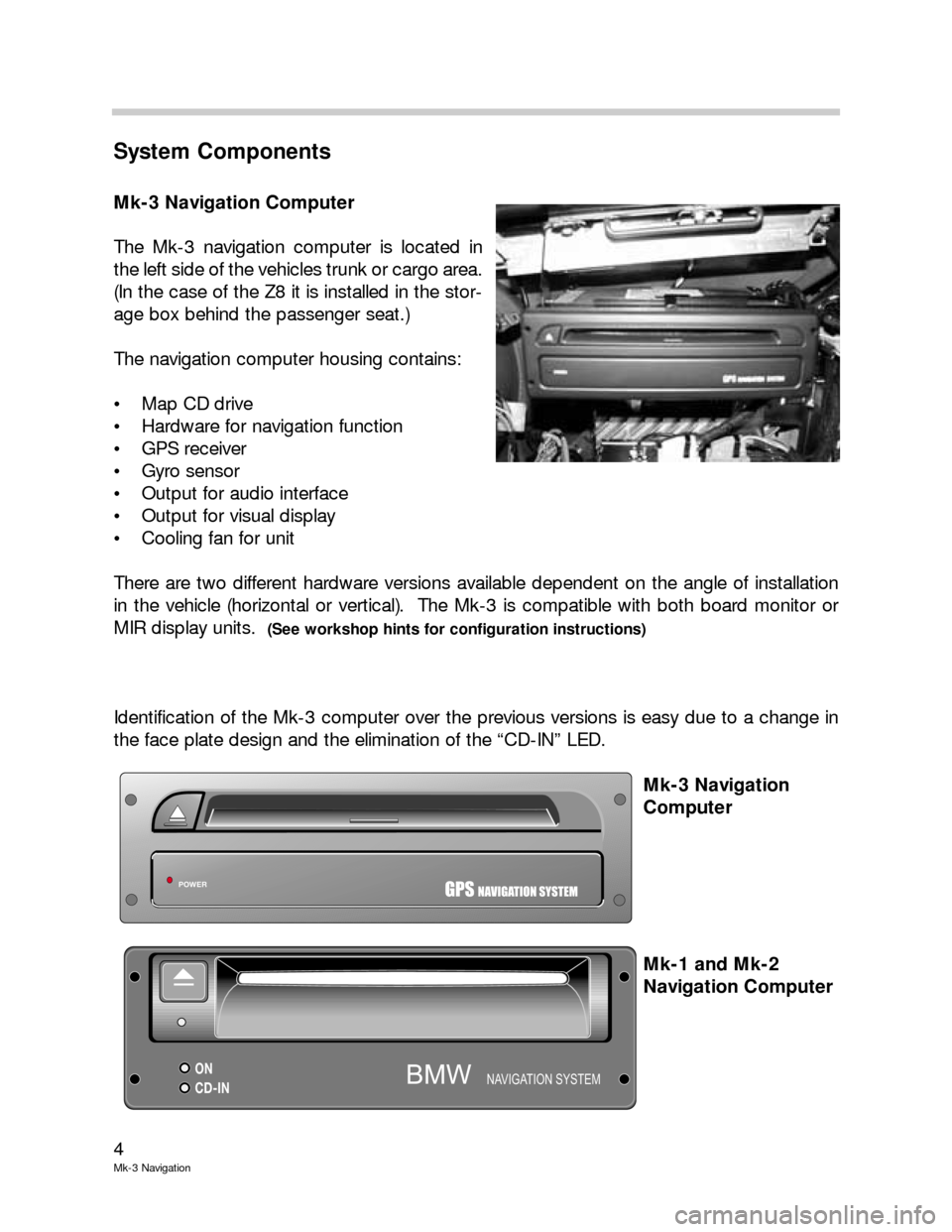
The Mk-3 navigation computer is located in
the left side of the vehicles trunk or cargo area.
(In the case of the Z8 it is installed in the stor-
age box behind the passenger seat.)
The navigation computer housing contains:
Map CD drive
Hardware for navigation function
GPS receiver
Gyro sensor
Output for audio interface
Output for visual display
Cooling fan for unit
There are two different hardware versions available dependent on the angle of installation
in the vehicle (horizontal or vertical). The Mk-3 is compatible with both board monitor or
MIR display units.
(See workshop hints for configuration instructions)
Identification of the Mk-3 computer over the previous versions is easy due to a change in
the face plate design and the elimination of the “CD-IN” LED.
Mk-3 Navigation
Computer
Mk-1 and Mk-2
Navigation Computer
POWERGPSNAVIGATION SYSTEM
ON
CD-INNAVIGATION SYSTEMBMW
Page 5 of 17
5
Mk-3 navigation
GPS (Global Positioning System) Receiver
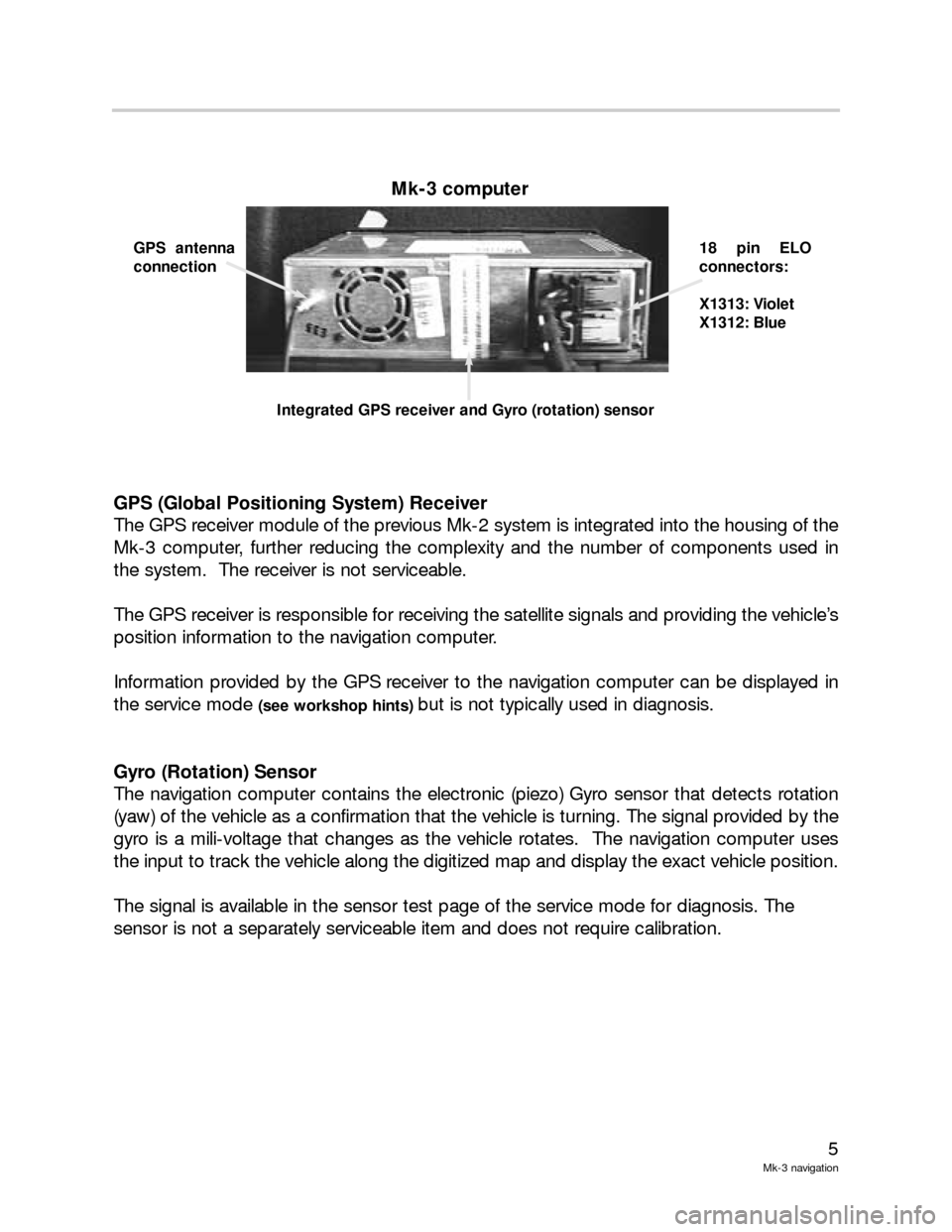
The GPS receiver module of the previous Mk-2 system is integrated into the housing of the
Mk-3 computer, further reducing the complexity and the number of components used in
the system. The receiver is not serviceable.
The GPS receiver is responsible for receiving the satellite signals and providing the vehicle’s
position information to the navigation computer.
Information provided by the GPS receiver to the navigation computer can be displayed in
the service mode
(see workshop hints) but is not typically used in diagnosis.
Gyro (Rotation) Sensor
The navigation computer contains the electronic (piezo) Gyro sensor that detects rotation
(yaw) of the vehicle as a confirmation that the vehicle is turning. The signal provided by the
gyro is a mili-voltage that changes as the vehicle rotates. The navigation computer uses
the input to track the vehicle along the digitized map and display the exact vehicle position.
The signal is available in the sensor test page of the service mode for diagnosis. The
sensor is not a separately serviceable item and does not require calibration.
Mk-3 computer
GPS antenna
connection18 pin ELO
connectors:
X1313: Violet
X1312: Blue
Integrated GPS receiver and Gyro (rotation) sensor
Page 6 of 17
6
Mk-3 Navigation
GPS Antenna
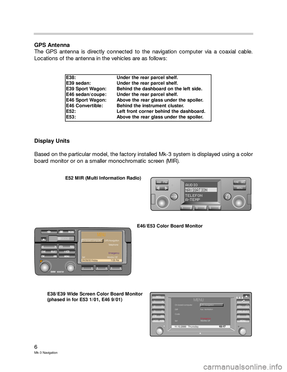
The GPS antenna is directly connected to the navigation computer via a coaxial cable.
Locations of the antenna in the vehicles are as follows:
Display Units
Based on the particular model, the factory installed Mk-3 system is displayed using a color
board monitor or on a smaller monochromatic screen (MIR).
AM FM
MODE
TONESEL
MENU
123456
AUDIO
NAVIGATION
TELEFONA-TEMP
11.13.2000Thursday10:17
INFO
1
4
25
36
FM AM
MODEMENU
TONE SELECT
MENUOn-board computer
DSP
Code
SetGPS-Navigation
Monitor off Emergency
Aux. Ventilation
DOLBY B-C NR
12BMW34
MODE
56
TONE SELECTFM AM
PTY RDS
MENU
MONITOR
09/08/00 Friday 7:05 PM
MENU
On-board computer
Telephone
onitor Off GPS-Navigation
Set MEmergency
E52 MIR (Multi Information Radio)
E46/E53 Color Board Monitor
E38/E39 Wide Screen Color Board Monitor
(phased in for E53 1/01, E46 9/01)
E38: Under the rear parcel shelf.
E39 sedan: Under the rear parcel shelf.
E39 Sport Wagon: Behind the dashboard on the left side.
E46 sedan/coupe: Under the rear parcel shelf.
E46 Sport Wagon: Above the rear glass under the spoiler.
E46 Convertible: Behind the instrument cluster.
E52: Left front corner behind the dashboard.
E53: Above the rear glass under the spoiler.
Page 7 of 17
7
Mk-3 navigation
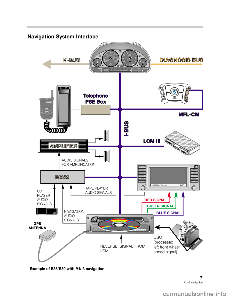
Navigation System Interface
RED SIGNAL
GREEN SIGNAL
BLUE SIGNAL
LCM IIILCMIII
MFL-CM Telephone
PSE Box
Telephone
PSE
Box
I-BUS
K-BUSDIAGNOSIS BUS DIAGNOSISBUS
SRS
AIRBAGSRS
AIRBAG
BMW
BM53
NAVIGATION
AUDIO
SIGNALS
GPS
ANTENNA
CD
PLAYER
AUDIO
SIGNALSAUDIO SIGNALS
FOR AMPLIFICATION
TAPE PLAYER
AUDIO SIGNALS
AMPLIFIER
DSC
(processed
left front wheel
speed signal)
REVERSE SIGNAL FROM
LCM
POWERGPSNAVIGATION SYSTEM
13.07.2000Thursday10 : 17
INFO
1
4
25
36
FM AMMODEMENU
TONE SELECT
BOSCH
0½
CHECK
ENGINECHECK
ENGINEOIL SERVICEOILSERVICEINSPECTIONP
1/min
x 1000
km/hELECTRONICMPH
1
20204040
6060
8080100180160140 1201002001202201402400234
5
6
7
!!ABS20 DIGIT READOUT123456PRND SM
54321122 4720Fmiles
0
10
15 20 40
+
BMW
StarTAC
Example of E38/E39 with Mk-3 navigation
Page 8 of 17
8
Mk-3 Navigation
Information/body bus Interface
The navigation computer is integrated into the vehicle bus system as it’s main communica-
tion link with the vehicle.
Communication occurs with the following modules:
BMBT- Control inputs
Radio- Display data
GM- Door open
IKE/Kombi- On-board computer data
Telephone PSE Box- Monitor display data, mayday function
DISplus- Coding data
PSE = Portable Support Electronics
Video/Audio Signals
Board Monitor (Top Navigation)
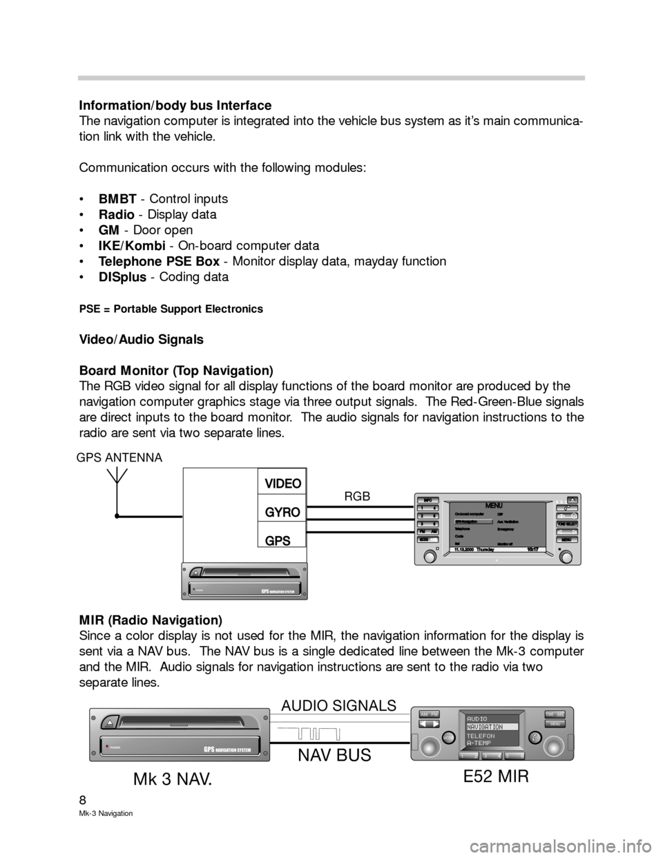
The RGB video signal for all display functions of the board monitor are produced by the
navigation computer graphics stage via three output signals. The Red-Green-Blue signals
are direct inputs to the board monitor. The audio signals for navigation instructions to the
radio are sent via two separate lines.
MIR (Radio Navigation)
Since a color display is not used for the MIR, the navigation information for the display is
sent via a NAV bus. The NAV bus is a single dedicated line between the Mk-3 computer
and the MIR. Audio signals for navigation instructions are sent to the radio via two
separate lines.
AM FM
MODE
TONESELMENU
123456
AUDIONAVIGATIONTELEFONA-TEMPPOWERGPSNAVIGATION SYSTEM
E52 MIR
Mk3NAV.
NAV BUS
AUDIO SIGNALS
11.13.2000Thursday10 : 17
INFO
1
4
25
253636FM AMMODEMENUMENU
TONE SELECTTONESELECT
MENUOn-board computer
Telephone
Code
SetOn-board computer
Telephone
Code
SetGPS-NavigationDSP
Aux. Ventilation
Emergency
Monitor offDSP
Aux.Ventilation
Emergency
Monitor off
RGB
POWERGPSNAVIGATION SYSTEM
VIDEO
GYRO
GPSVIDEO
GYRO
GPS
GPS ANTENNA
Page 10 of 17
10
Mk-3 Navigation
Principle of Operation
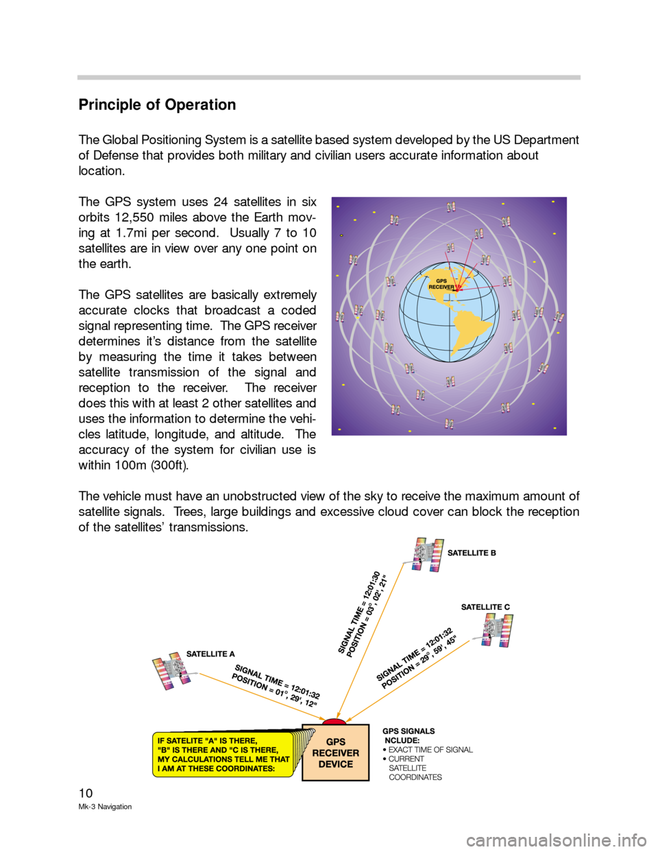
The Global Positioning System is a satellite based system developed by the US Department
of Defense that provides both military and civilian users accurate information about
location.
The GPS system uses 24 satellites in six
orbits 12,550 miles above the Earth mov-
ing at 1.7mi per second. Usually 7 to 10
satellites are in view over any one point on
the earth.
The GPS satellites are basically extremely
accurate clocks that broadcast a coded
signal representing time. The GPS receiver
determines it’s distance from the satellite
by measuring the time it takes between
satellite transmission of the signal and
reception to the receiver. The receiver
does this with at least 2 other satellites and
uses the information to determine the vehi-
cles latitude, longitude, and altitude. The
accuracy of the system for civilian use is
within 100m (300ft).
The vehicle must have an unobstructed view of the sky to receive the maximum amount of
satellite signals. Trees, large buildings and excessive cloud cover can block the reception
of the satellites’ transmissions.
Page 11 of 17
11
Mk-3 navigation
The GPS antenna passes the signal to the GPS receiver incorporated in the navigation
computer. A CD with map data is loaded in the CD drive of the navigation computer. The
navigation computer combines the vehicle position calculated by the GPS with this map
data.
The current position of the vehicle can be shown on the on-board monitor by selecting
“Emergency” from the main menu.
The driver can enter a destination. The navigation computer calculates a route from the
current location to this destination based on selectable criteria (main use of highways,
shortest distance, etc.). The calculated route is shown in the route display.
The navigation computer generates the RGB color video signal for all on-board monitor
displays. These three signals are sent over separate shielded wires to the on-board mon-
itor.
In the case of the E52 MIR (also referred as radio navigation) which does not have a color
display, the visual display data is sent via one wire called the navigation bus. On both sys-
tems, color and monochrome display, the audio output from the navigation computer for
voice directions is sent over two separate wires.
The driver has the choice of displays that utilize a color map with an icon of the vehicle
being traced on the map or the use of arrow indicators and distance data shown on the
on-board monitor display. Vehicles equipped with the wide screen board monitor have a
split screen option that includes both display methods. The MIR only makes use of the
arrows and distance display. With the assistance of voice prompts, the navigation
computer indicates how and where to get into the correct lane or turn off.
The navigation computer calculates the distance traveled from the wheel speed signal
delivered by the DSC control unit.
The gyro incorporated into the navigation computer housing informs the navigation com-
puter when the vehicle is turning. An alternative route is re-calculated automatically if the
driver does not follow the original route instructions.
Once the driver has reached their destination, the navigation computer is ready for
another destination input.
Refer to the on-board monitor owners manual for instructions on using the navigation system
software.