navigation Citroen DS5 RHD 2015.5 1.G Owner's Guide
[x] Cancel search | Manufacturer: CITROEN, Model Year: 2015.5, Model line: DS5 RHD, Model: Citroen DS5 RHD 2015.5 1.GPages: 400, PDF Size: 23.96 MB
Page 342 of 400
11
1
16
17
18
42
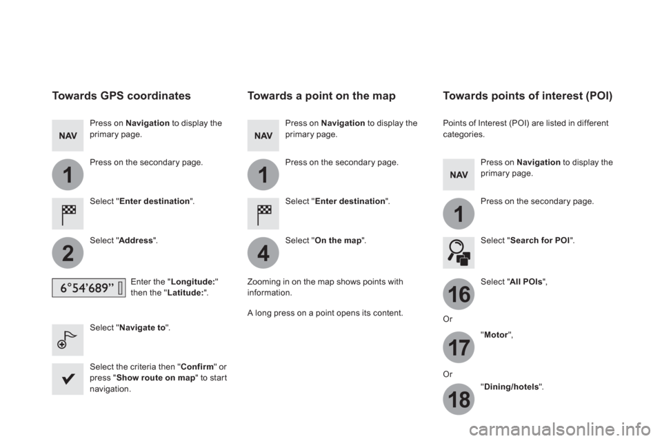
Towards GPS coordinates
Select " Enter destination
".
Select " Address
".
Enter the " Longitude:
"
then the " Latitude:
".
Select " Navigate to
".
Select the criteria then " Confirm
" or
press " Show route on map
" to start
navigation.
Press on Navigation
to display the
primary page.
Press on the secondary page.
Towards a point on the map
Select " Enter destination
".
Select " On the map
".
Press on Navigation
to display the
primary page.
Press on the secondary page.
Zooming in on the map shows points with
information.
A long press on a point opens its content.
Towards points of interest (POI)
Points of Interest (POI) are listed in different
categories.
Press on Navigation
to display the
primary page.
Press on the secondary page.
Select " Search for POI
".
Select " All POIs
",
Or
" Motor
",
Or
" Dining/hotels
".
Page 343 of 400
17 Audio and Telematics
An annual mapping update allows new
points of interest to be presented to
you.
You can also update the Risk areas /
Danger areas every month.
The detailed procedure is available on:
http://citroen.navigation.com.
Page 344 of 400
11
23
24
25
32
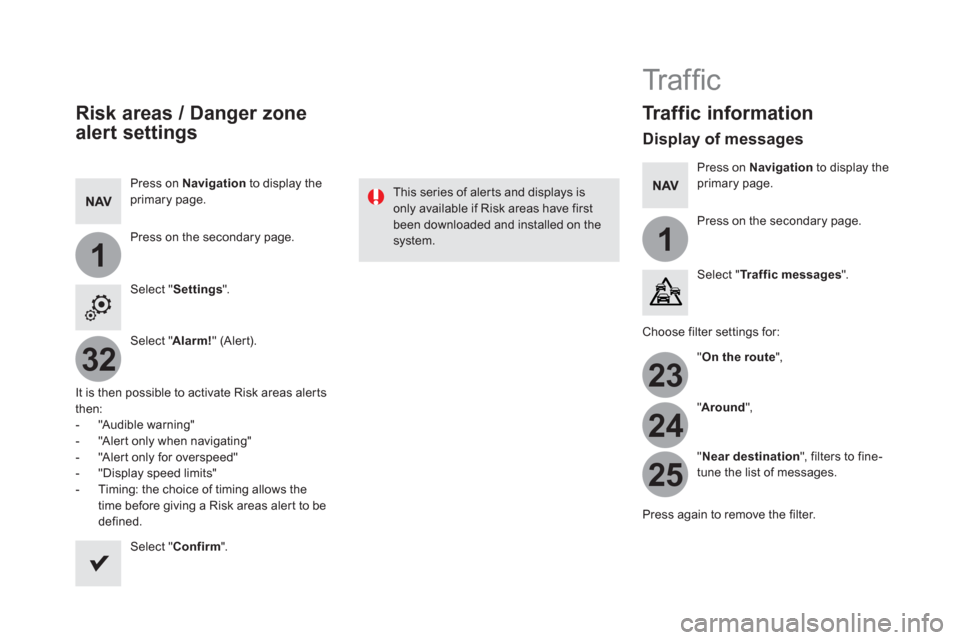
Risk areas / Danger zone
alert settings
Press on Navigation
to display the
primary page.
Press on the secondary page.
Select " Settings
".
Select " Alarm!
" (Alert).
It is then possible to activate Risk areas alerts
then:
- "Audible warning"
- "Alert only when navigating"
- "Alert only for overspeed"
- "Display speed limits"
- Timing: the choice of timing allows the
time before giving a Risk areas alert to be
defined.
Select " Confirm
".
This series of alerts and displays is
only available if Risk areas have first
been downloaded and installed on the
system.
Tr a ffi c
Traffic information
Display of messages
Press on Navigation
to display the
primary page.
Press on the secondary page.
Select " Tr a f f i c m e s s a g e s
".
Choose filter settings for:
" On the route
",
" Around
",
" Near destination
", filters to fine-
tune the list of messages.
Press again to remove the filter.
Page 345 of 400
11
3133
19 Audio and Telematics
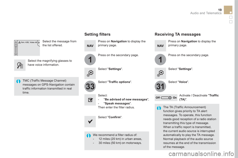
Select the message from
the list offered.
Select the magnifying glasses to
have voice information.
Setting fi lters
Press on Navigation
to display the
primary page.
Press on the secondary page.
Select " Settings
".
Select " Traffic options
".
Select:
- " Be advised of new messages
",
- " Speak messages
".
Then enter the filter radius.
Select " Confirm
".
We recommend a filter radius of:
- 12 miles (20 km) in urban areas,
- 30 miles (50 km) on motor ways.
TMC (Traffic Message Channel)
messages on GPS-Navigation contain
traffic information transmitted in real
time.
The TA (Traffic Announcement)
function gives priority to TA alert
messages. To operate, this function
needs good reception of a radio station
transmitting this type of message.
When a traffic report is transmitted,
the current audio source is interrupted
automatically to play the TA message.
Normal playback of the audio source
resumes at the end of the transmission
of the message.
Receiving TA messages
Press on Navigation
to display the
primary page.
Press on the secondary page.
Select " Settings
".
Select " Voice
".
Activate / Deactivate " Tr a f f i c
(TA)
".
Page 388 of 400
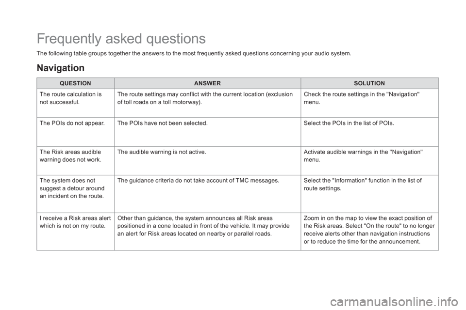
The following table groups together the answers to the most frequently asked questions concerning your audio system.
QUESTION
ANSWER
SOLUTION
The route calculation is
not successful. The route settings may conflict with the current location (exclusion
of toll roads on a toll motor way). Check the route settings in the "Navigation"
menu.
The POIs do not appear. The POIs have not been selected. Select the POIs in the list of POIs.
The Risk areas audible
warning does not work. The audible warning is not active. Activate audible warnings in the "Navigation"
menu.
The system does not
suggest a detour around
an incident on the route. The guidance criteria do not take account of TMC messages. Select the "Information" function in the list of
route settings.
I receive a Risk areas alert
which is not on my route. Other than guidance, the system announces all Risk areas
positioned in a cone located in front of the vehicle. It may provide
an alert for Risk areas located on nearby or parallel roads. Zoom in on the map to view the exact position of
the Risk areas. Select "On the route" to no longer
receive alerts other than navigation instructions
or to reduce the time for the announcement.
Frequently asked questions
Navigation