navigation HONDA INSIGHT 2020 Navigation Manual (in English)
[x] Cancel search | Manufacturer: HONDA, Model Year: 2020, Model line: INSIGHT, Model: HONDA INSIGHT 2020Pages: 127, PDF Size: 3 MB
Page 99 of 127
97
uuChanging Your Destination uEntering a New Destination
Navigation
Entering a New Destination
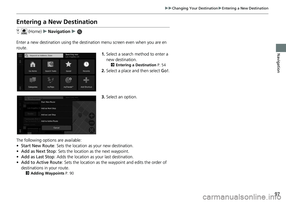
H (Home) uNavigation u
Enter a new destination using the destinat ion menu screen even when you are en
route.
1.Select a search method to enter a
new destination.
2 Entering a Destination P. 54
2.Select a place and then select Go!.
3. Select an option.
The following options are available:
• Start New Route : Sets the location as your new destination.
• Add as Next Stop : Sets the location as the next waypoint.
• Add as Last Stop : Adds the location as your last destination.
• Add to Active Route : Sets the location as the waypoint and edits the order of
destinations in your route.
2 Adding Waypoints P. 90
Page 102 of 127
100
Troubleshooting
Troubleshooting
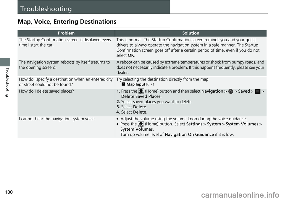
Map, Voice, Entering Destinations
ProblemSolution
The Startup Confirmation screen is displayed every
time I start the car.This is normal. The Startup Confirmation screen reminds you and your guest
drivers to always operate the navigation system in a safe manner. The Startup
Confirmation screen goes off after a certa in period of time, even if you do not
select OK.
The navigation system reboots by itself (returns to
the opening screen).A reboot can be caused by extreme temper atures or shock from bumpy roads, and
does not necessarily indicate a problem. If this happens frequently, please see your
dealer.
How do I specify a destination when an entered city
or street could not be found?Try selecting the destination directly from the map.
2 Map Input P. 71
How do I delete saved places?1.Press the (Home) button and then select Navigation > > Saved > >
Delete Sa ved Places .
2. Select saved places you want to delete.
3. Select Delete .
4. Select Delete .
I cannot hear the navigation system voice.●Adjust the volume using the volume knob during the voice guidance.●Press the (Home) button. Select Settings > System > System Volumes >
System Volumes .
Turn up volume level of Navigation On Guidance if it is low.
Page 104 of 127
102
uuTroubleshooting uGuidance, Routing
Troubleshooting
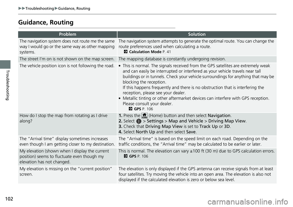
Guidance, Routing
ProblemSolution
The navigation system does not route me the same
way I would go or the same way as other mapping
systems.The navigation system attempts to generate the optimal route. You can change the
route preferences used wh en calculating a route.
2Calculation Mode P. 41
The street I’m on is not shown on the map screen.The mapping database is constantly undergoing revision.
The vehicle position icon is not following the road. ●This is normal. The signals received fro m the GPS satellites are extremely weak
and can easily be interrupted or interfered as your vehicle travels near tall
buildings or in tunnels. Check your vehicle surroundings for anything that may be
blocking the reception.
If this happens frequently and there is no obstruction that is interfering the
reception, please see your dealer.
●Metallic tinting or other aftermarket devices can interfere with GPS reception.
Please consult your dealer.
2 GPS P. 106
How do I stop the map from rotating as I drive
along?1.Press the (Home) button and then select Navigation.
2. Select > Settings > Map and Vehicle > Driving Map View .
3. Check that Driving Map View is set to Track Up or 3D.
4. Select North Up and then select Save.
The “Arrival time” displa y sometimes increases
even though I am getting closer to my destination.The “Arrival time” is based on the speed limit on each road. Depending on the
traffic conditions, the “Arrival time” may be calculated to be earlier or later.
My elevation (shown when I display the current
position) seems to fluc tuate even though my
elevation has not changed.This is normal. The elevation can vary ±100 ft (30 m) due to GPS calculation errors.
2 GPS P. 106
My elevation is missing on the “current position”
screen.The elevation is only displayed if the GP S antenna can receive signals from at least
four satellites. Try moving the vehicle into an open area. The elevation is also not
displayed if the calculated elevation is zero or below sea level.
Page 105 of 127
103
uuTroubleshooting uUpdate, Coverage, Map Errors
Troubleshooting
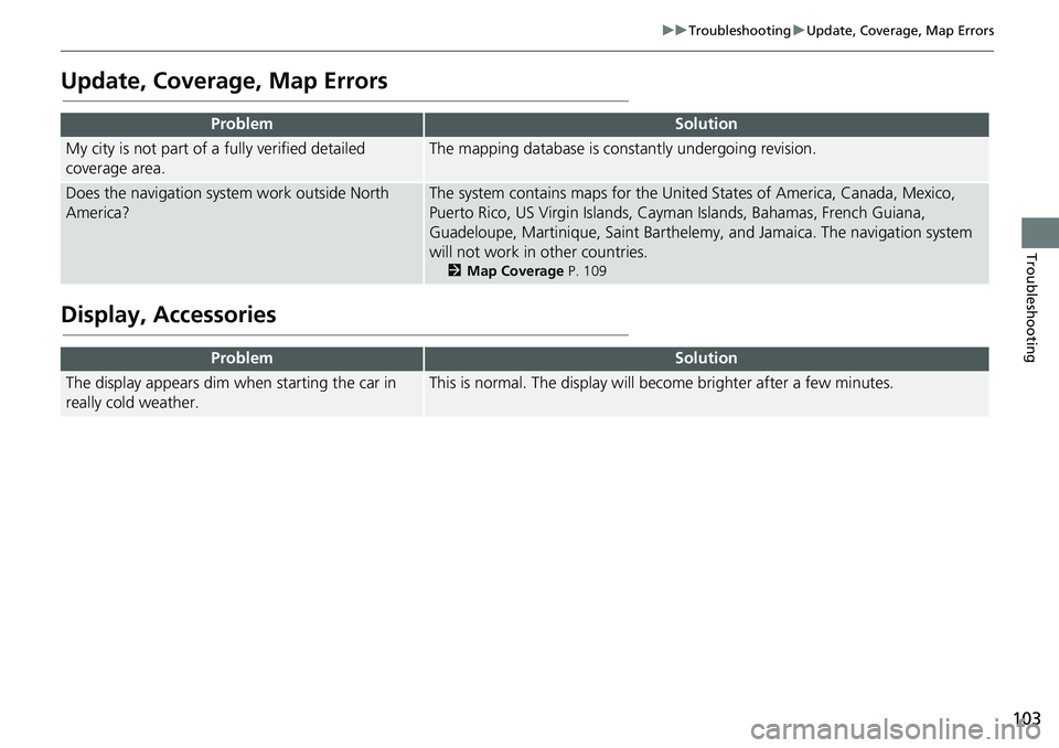
Update, Coverage, Map Errors
Display, Accessories
ProblemSolution
My city is not part of a fully verified detailed
coverage area.The mapping database is constantly undergoing revision.
Does the navigation system work outside North
America?The system contains maps for the United States of America, Canada, Mexico,
Puerto Rico, US Virgin Islands, Cayman Islands, Bahamas, French Guiana,
Guadeloupe, Martinique, Saint Barthelemy, and Jamaica. The navigation system
will not work in other countries.
2 Map Coverage P. 109
ProblemSolution
The display appears dim when starting the car in
really cold weather.This is normal. The display will become brighter after a few minutes.
Page 107 of 127
105
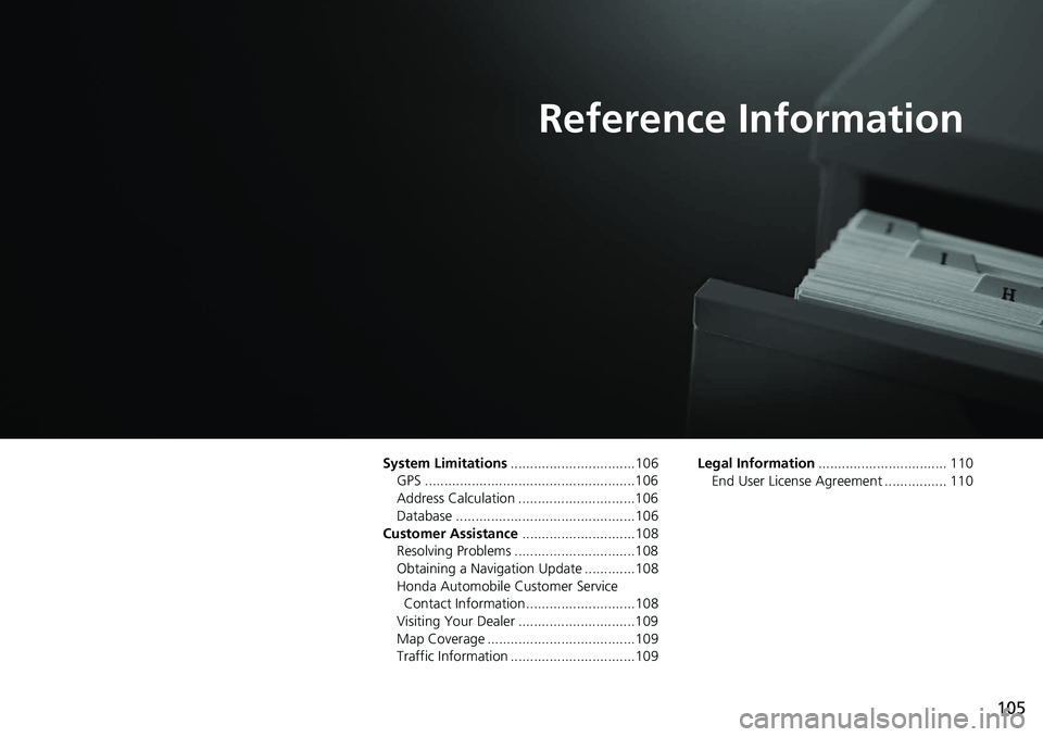
Reference Information
System Limitations................................106
GPS ......................................................106
Address Calculation ..............................106
Database ..............................................106
Customer Assistance .............................108
Resolving Problems ...............................108
Obtaining a Navigation Update .............108
Honda Automobile Customer Service Contact Information ............................108
Visiting Your Dealer ..............................109
Map Coverage ......................................109
Traffic Information ................................109 Legal Information
................................. 110
End User License Agreement ................ 110
Page 108 of 127
106
Reference Information
System Limitations
GPS
The signals received from GPS satellites are
extremely weak (less than a millionth of the
strength of a local FM station) and require
an unobstructed view of the sky. The GPS
antenna is located in the fin antenna. The
signal reception can easily be interrupted or
interfered with by the following:
• Audio electronic devices mounted near the navigation unit
• Trees, tall buildings, highway overpasses,
tunnels, or overhead electrical power
wires
GPS is operated by the U.S. Department of
Defense. For security reasons, there are
certain inaccuracies bui lt into GPS for which
the navigation system must constantly
compensate. This can cause occasional
positioning errors of up to several hundred
feet (meters).
Address Calculation
The destination icon shows only the
approximate location of a destination
address. This occurs if the number of
possible addresses is different from the
number of actual addr esses on a block. For
example, the address 1425 on a 1400 block
with 100 possible addresses (because it is
followed by the 1500 block) will be shown a
quarter of the way down the block by the
system. If there are only 25 actual addresses
on the block, the actual location of address
1425 would be at the end of the block.
Database
The digitized map database reflects
conditions as they existed at various points
in time before production. Accordingly,
your database may contain inaccurate or
incomplete data or information due to the
passage of time, road construction,
changing conditions, or other causes.
For example, some places/landmarks may
be missing when you search the database
because the name was misspelled, the place
was improperly categorized, or a place/
landmark is not yet in the database. This is
also true for police st ations, hospitals, and
other public institutions. Do not rely on the
navigation system if you need law
enforcement or hospital services. Always
check with local in formation sources.
Page 109 of 127
107
uuSystem Limitations uDatabase
Reference Information
The database does not include, analyze,
process, consider, or reflect any of the
following categories of information:
• Neighborhood quality or safety
• Population density
• Availability or proximity of law
enforcement
• Emergency, rescue, medical, or other assistance
• Construction work, zones, or hazards
• Road and lane closures
• Legal restrictions (such as vehicular type, weight, load, height, and speed
restrictions)
• Road slope or grade
• Bridge height, width, weight, or other
limits
• Traffic facilities safety
• Special events
• Pavement characteristics or conditions Every effort has been made to verify that
the database is accurate. The number of
inaccuracies you expe
rience increases the
longer you go with out obtaining an
updated map database.
2 Obtaining a Navigation Update P. 108
We assume no liability for any incident that
may result from an error in the program, or
from changed conditions not noted above.
Page 110 of 127
108
Reference Information
Customer Assistance
Resolving Problems
If you run into a specific issue that you
cannot resolve, consult the following help
resources:
• For navigation system issues:
2Troubleshooting P. 100
Or, please contact your dealer.
• For traffic-related issues:
2 Traffic P. 101
• For reporting issues with the database or
places/landmarks:
• Visit
https://my.garmin. com/mapErrors/
report.fac es
• Or call Garmin OEM support directly at (855) 607-2536.
Obtaining a Navigation
Update
Honda is continuously updating the
navigation system and new software is
usually made available on an annual basis.
For information on navigation updates for
your vehicle, please visit:
• U.S.: hondanavi.navigation. com
• Canada: www.honda. ca/owners/honda-
servi ces/navigation
You can also contact your Honda
authorized dealer for further information
regarding the update program available for
your vehicle.
Honda Automobile
Customer Service Contact
Information
Honda Navi
American Honda Motor Co., Inc.
Honda Automobile Customer Service
Mail Stop 100-5E-8A
1919 Torrance Blvd.
Torrance, CA 90501-2746
Tel: (800) 999-1009
Fax: (310) 783-3023
Honda Canada Inc.
Honda Customer Relations
180 Honda Blvd.
Markham, ON
L6C 0H9
Tel: (888)-9-HONDA-9
Hours: 8:00 am to 7:30 pm Mon to Fri (EST)
Page 111 of 127
109
uuCustomer Assistance uVisiting Your Dealer
Reference Information
Visiting Your Dealer
If you have a question that you cannot
resolve using the available help resources,
you can consult your dealer. Please identify
the specific issue (e.g., error occurs when
you enter a specific a ddress, when driving
on a certain road, or just when it’s cold) so
that the service advisor can refer the issue to
the factory so that a so lution can be found.
Be patient, the service advisor may be
unfamiliar with your specific issue.
Map Coverage
The system provides maps for the United
States of America, Canada, Mexico, Puerto
Rico, US Virgin Islands, Cayman Islands,
Bahamas, French Guiana, Guadeloupe,
Martinique, Saint Barth elemy, and Jamaica.
The navigation system will not work in other
countries.
Traffic Information
Continuously updated traffic information is
available in major metropolitan areas across
contiguous United States and some cities in
Canada.
Page 112 of 127
110
Reference Information
Legal Information
End User License Agreement
The infotainment system you have
purchased for your vehicle may contain a
navigation solution ("Navigation Solution").
The software embedded in the Navigation
Solution (the "Software") is owned by the
navigation solution provider or its
subsidiaries (collectively, "Navigation
Provider"). The map data that may be
embedded in your Navigation Solution or
downloaded separately (the "Map Data") is
either owned by the Navigation Provider, or
by HERE North America LLC and/or its
affiliates ("HERE") or another third party
and licensed to the Navigation Provider.
The Navigation Provider also owns, or
licenses from third party providers,
information, traffic data, text, images,
graphics, photographs, audio, video,
images and other applications and data that
may be embedded in the Navigation
Solution, or downloaded separately ("Other
Content"). The Map Data and Other
Content are collectively the "Content". The
Software and Content (collectively, the
"Navigation Provider Products") are
protected under copyright laws and
international copyri ght treaties. The Navigation Provider Products are licensed,
not sold. The structure, organization and
code of the Software are valuable trade
secrets of the Navigation Provider and/or its
third-party providers. The Navigation
Provider Products ar
e each provided under
this License Agreemen t and are subject to
the following terms an d conditions which
are agreed to by End User ("you" or
"your"), on the one hand, and the
Navigation Provider and its licensors and
affiliated companies of the Navigation
Provider and its licensors, on the other
hand. The Navigation Provider's licensors,
including the licensors, service providers,
channel partners, suppliers and affiliated
companies of the Navigation Provider and
its licensors, are each a direct and intended
third party beneficiary of this Agreement
and may enforce their rights directly against
you in the event of your breach of this
Agreement.
IMPORTANT: CAREFULLY READ THIS
ENTIRE LICENSE AGREEMENT BEFORE
PURCHASING OR USING YOUR
NAVIGATION SOLUTION OR CONTENT.
PURCHASING, INSTALLING, COPYING, OR
OTHERWISE USING YOUR NAVIGATION SOLUTION OR CONTENT CONSTITUTES
YOUR ACKNOWLEDGMENT THAT YOU
HAVE READ THIS LICENSE AGREEMENT
AND AGREE TO ITS TERMS AND
CONDITIONS.
The Navigation Provider grants you a limited,
non-exclusive license to use the applicable
Navigation Provider Product in accordance
with the terms of this Agreement. You agree
to use the applicable Navigation Provider
Product for solely personal use, or if
applicable, for use in your business' internal
operations, and not for service bureau, time-
sharing, resale or other similar purposes. You
agree not to otherwise reproduce, archive,
copy, modify, decompile, disassemble, reverse
engineer or create derivative works of any
portion of the Navigation Solution, and may
not transfer or distribute it in any form, for any
purpose, except to the extent permitted by
mandatory laws. The Navigation Provider also
reserves the right to discontinue offering any
Content supplied by any third party supplier if
such supplier ceases to supply such content or
the Navigation Provider's contract with such
supplier terminates for any reason.
■
License Terms and Conditions