ad blue HONDA PILOT 2009 2.G Navigation Manual
[x] Cancel search | Manufacturer: HONDA, Model Year: 2009, Model line: PILOT, Model: HONDA PILOT 2009 2.GPages: 156, PDF Size: 6.14 MB
Page 60 of 156
60Navigation System
Showing Icons on the Map
Selecting Show Icon on Map from
the Map menu (see page52) displays
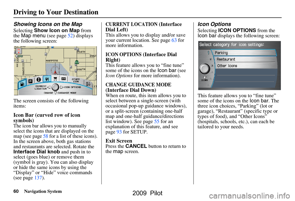
the following screen:
The screen consists of the following
items:
Icon Bar (curved row of icon
symbols)
The icon bar allows you to manually
select the icons that are displayed on the
map (see page58 for a list of these icons).
In the screen above, both gas stations
and restaurants are selected. Rotate the
Interface Dial knob and push in to
select (goes blue) or remove them
(symbol is gray). You can also display
or hide the same icons by using the
“Display” or “Hide” voice commands
(see page137).
CURRENT LOCATION (Interface
Dial Left)
This allows you to display and/or save
your current location. See page63 for
more information.
ICON OPTIONS (Interface Dial
Right)
This feature allows you to “fine tune”
some of the icons on the Icon bar (see
Icon Options for more information).
CHANGE GUIDANCE MODE
(Interface Dial Down)
When en route, this item allows you to
select between a single-screen (with
occasional pop-up guidance windows),
or a split-screen (containing one-half
map and one-half guidance/directions
list window). See page55 for an
explanation of this feature, and see
page93 for SETUP.
Exit Screen
Press the CANCEL button to return to
the map screen.
Icon Options
Selecting ICON OPTIONS from the
Icon bar displays the following screen:
This feature allows you to “fine tune”
some of the icons on the Icon bar. The
three icon choices, “Parking” (lot or
garage), “Restaurant” (specific type or
types of food), and “Other Icons”
(hospitals, schools, etc.), can each be
tailored to your needs.
Driving to Your Destination
2009 Pilot
Page 61 of 156
Navigation System61
Driving to Your Destination
For instance, let’s assume that your
hospital is not displa yed on the map, and
you want to make sure that your settings
are correct. You would do the
following:
First, you would ensure that the “OTHER ICON” button on the Icon
bar is blue (see Icon Bar on page60).
Second, you select ICON OPTIONS
and verify that the hospital option is
also on (blue). This procedure is
explained below.
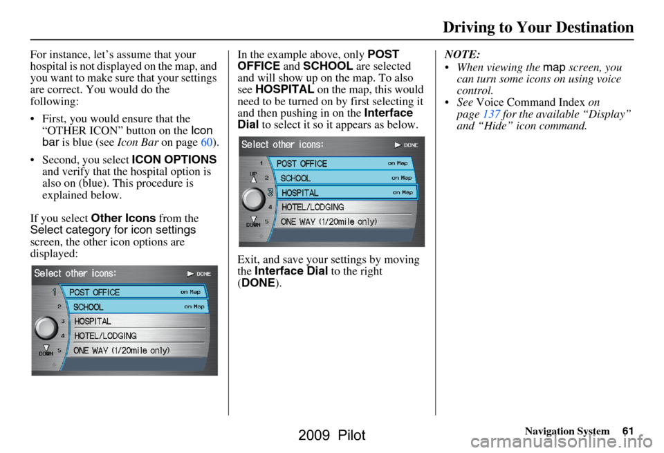
If you select Other Icons from the
Select category for icon settings
screen, the other icon options are
displayed: In the example above, only
POST
OFFICE and SCHOOL are selected
and will show up on the map. To also
see HOSPITAL on the map, this would
need to be turned on by first selecting it
and then pushing in on the Interface
Dial to select it so it appears as below.
Exit, and save your settings by moving
the Interface Dial to the right
( DONE ). NOTE:
When viewing the
map screen, you
can turn some icons on using voice
control.
See Voice Command Index on
page137 for the available “Display”
and “Hide” icon command.
2009 Pilot
Page 70 of 156
70Navigation System
Information Features
Information Screen
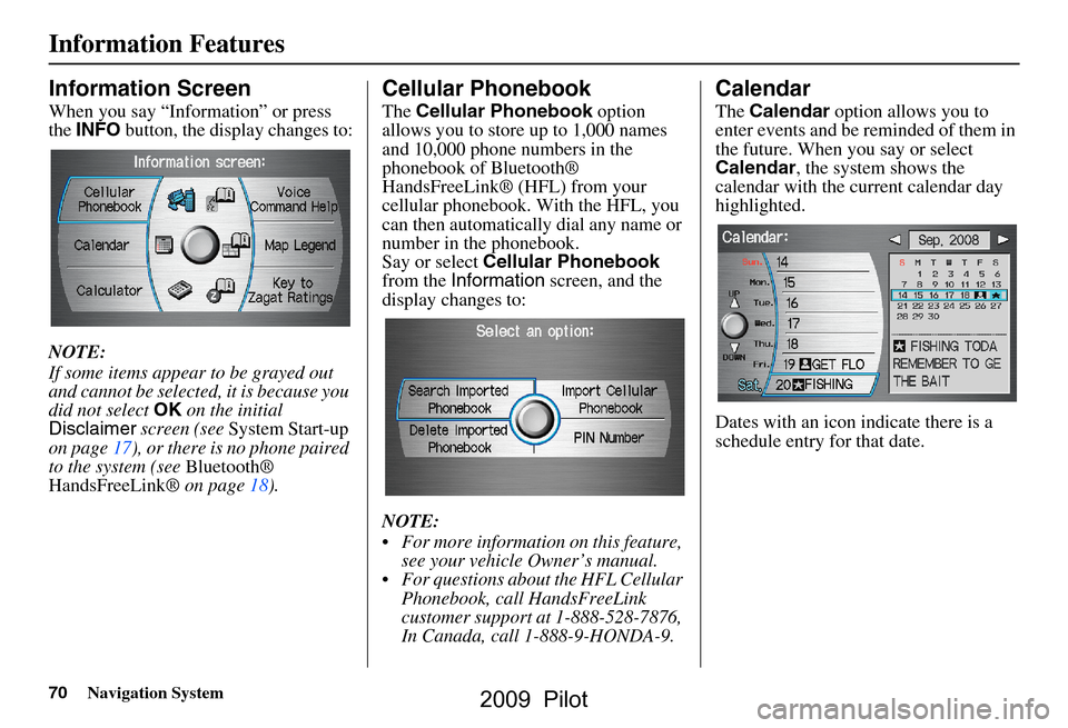
When you say “Information” or press
the INFO button, the display changes to:
NOTE:
If some items appear to be grayed out
and cannot be selected, it is because you
did not select OK on the initial
Disclaimer screen (see System Start-up
on page17), or there is no phone paired
to the system (see Bluetooth®
HandsFreeLink® on page18).
Cellular Phonebook
The Cellular Phonebook option
allows you to store up to 1,000 names
and 10,000 phone numbers in the
phonebook of Bluetooth®
HandsFreeLink® (HFL) from your
cellular phonebook. With the HFL, you
can then automatically dial any name or
number in the phonebook.
Say or select Cellular Phonebook
from the Information screen, and the
display changes to:
NOTE:
For more information on this feature, see your vehicle Owner’s manual.
For questions about the HFL Cellular Phonebook, call HandsFreeLink
customer support at 1-888-528-7876,
In Canada, call 1-888-9-HONDA-9.
Calendar
The Calendar option allows you to
enter events and be reminded of them in
the future. When you say or select
Calendar , the system shows the
calendar with the current calendar day
highlighted.
Dates with an icon indicate there is a
schedule entry for that date.
2009 Pilot
Page 75 of 156
Navigation System75
Information Features
“Cost” (white circle) is the average
cost of a meal (including drink and
tip).
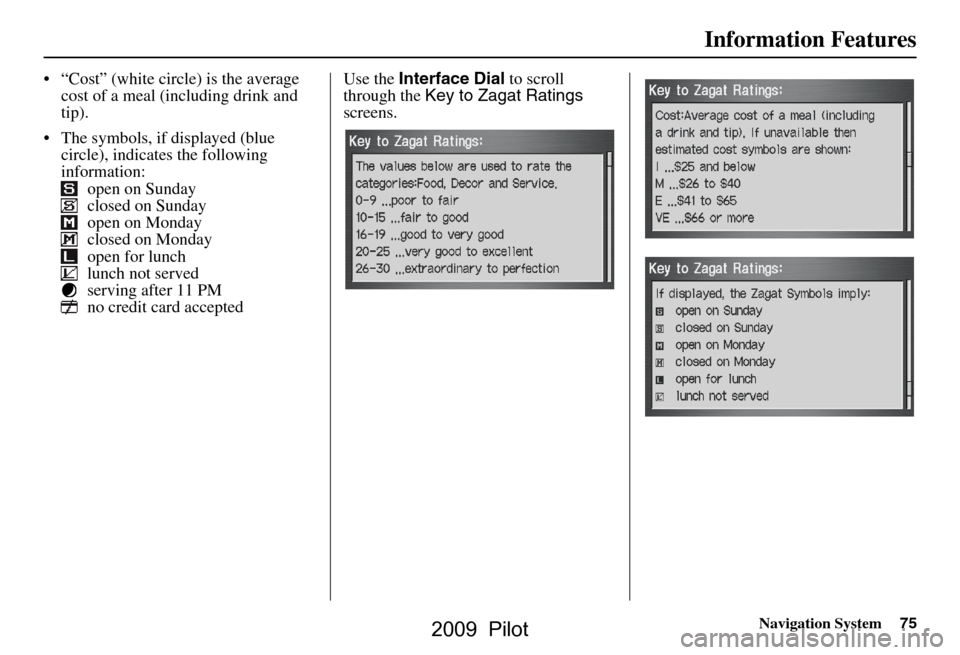
The symbols, if displayed (blue circle), indicates the following
information: open on Sunday
closed on Sunday
open on Monday
closed on Monday
open for lunch
lunch not served
serving after 11 PM
no credit card accepted Use the
Interface Dial to scroll
through the Key to Zagat Ratings
screens.
2009 Pilot
Page 86 of 156
86Navigation System
System Setup
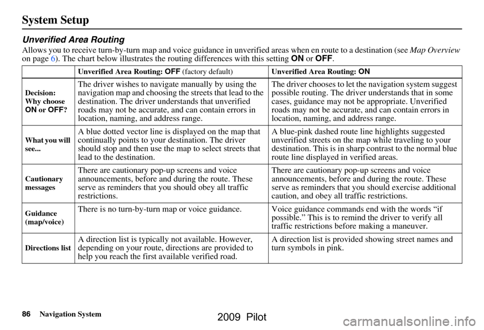
Unverified Area Routing
Allows you to receive turn-by-turn map and voice guidance in unverified areas when en route to a destination (see Map Overview
on page6). The chart below illustrates th e routing differences with this setting ON or OFF .
Unverified Area Routing: OFF (factory default) Unverified Area Routing: ON
Decision:
Why choose
ON or OFF ?
The driver wishes to navigate manually by using the
navigation map and choosing th e streets that lead to the
destination. The driver un derstands that unverified
roads may not be accurate, and can contain errors in
location, naming, and address range. The driver chooses to let th
e navigation system suggest
possible routing. The driver understands that in some
cases, guidance may not be appropriate. Unverified
roads may not be accurate, and can contain errors in
location, naming, and address range.
What you will
see...A blue dotted vector line is displayed on the map that
continually points to your destination. The driver
should stop and then use the map to select streets that
lead to the destination. A blue-pink dashed route line highlights suggested
unverified streets on the ma
p while traveling to your
destination. This is in sharp contrast to the normal blue
route line displayed in verified areas.
Cautionary
messagesThere are cautionary pop-up screens and voice
announcements, before and during the route. These
serve as reminders that you should obey all traffic
restrictions. There are cautionary pop-
up screens and voice
announcements, before and during the route. These
serve as reminders that you should exercise additional
caution, and obey all traffic restrictions.
Guidance
(map/voice)There is no turn-by-turn map or voice guidan ce. Voice guidance commands end with the words “if
possible.” This is to remind the driver to verify all
traffic restrictions before making a maneuver.
Directions listA direction list is typically not available. However,
depending on your route, directions are provided to
help you reach the first available verified road. A direction list is provided showing street names and
turn symbols in pink.
2009 Pilot
Page 88 of 156
88Navigation System
System Setup
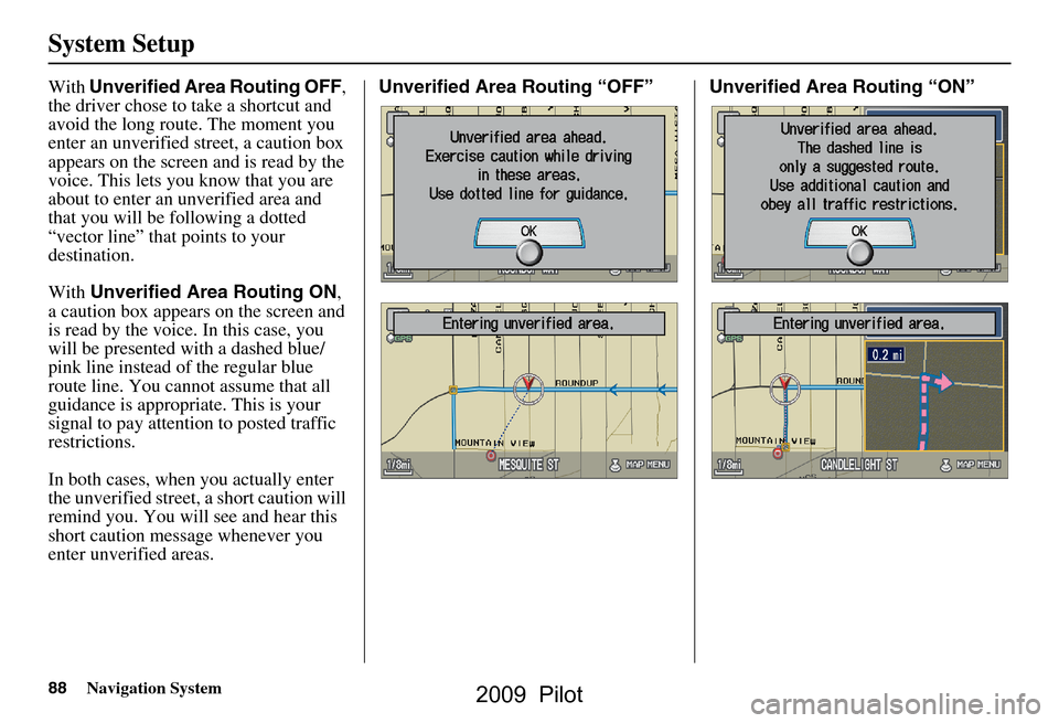
With Unverified Area Routing OFF ,
the driver chose to take a shortcut and
avoid the long route. The moment you
enter an unverified street, a caution box
appears on the screen and is read by the
voice. This lets you know that you are
about to enter an unverified area and
that you will be following a dotted
“vector line” that points to your
destination.
With Unverified Area Routing ON ,
a caution box appear s on the screen and
is read by the voice. In this case, you
will be presented with a dashed blue/
pink line instead of the regular blue
route line. You cannot assume that all
guidance is appropriate. This is your
signal to pay attention to posted traffic
restrictions.
In both cases, when you actually enter
the unverified street, a short caution will
remind you. You will see and hear this
short caution message whenever you
enter unverified areas. Unverified Area Routing “OFF” Unverified Area Routing “ON”
2009 Pilot
Page 89 of 156
Navigation System89
System Setup
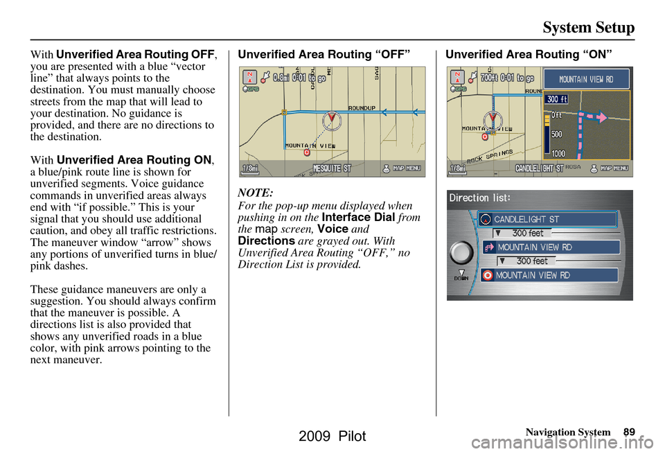
With Unverified Area Routing OFF ,
you are presented with a blue “vector
line” that always points to the
destination. You must manually choose
streets from the map that will lead to
your destination. No guidance is
provided, and there ar e no directions to
the destination.
With Unverified Area Routing ON ,
a blue/pink route line is shown for
unverified segmen ts. Voice guidance
commands in unverified areas always
end with “if possible.” This is your
signal that you should use additional
caution, and obey all traffic restrictions.
The maneuver window “arrow” shows
any portions of unverified turns in blue/
pink dashes.
These guidance maneuvers are only a
suggestion. You should always confirm
that the maneuver is possible. A
directions list is also provided that
shows any unverified roads in a blue
color, with pink arrows pointing to the
next maneuver. Unverified Area Routing “OFF”
NOTE:
For the pop-up menu displayed when
pushing in on the
Interface Dial from
the map screen, Voice and
Directions are grayed out. With
Unverified Area Routing “OFF,” no
Direction List is provided. Unverified Area
Routing “ON”
2009 Pilot
Page 116 of 156
116Navigation System
Coverage Areas
West VirginiaCharleston
Harper’s Ferry Metro
Wisconsin Appleton
Beloit
Green Bay
Janesville
Kenosha County
Madison
Lake Geneva
Milwaukee Metro – including
Milwaukee, Ozaukee, Washington,
and Waukesha Counties
Neenah
Oshkosh
Racine
Sheboygan
Wausau
Wyoming Cheyenne
Jackson Ski ResortsCanada Detailed Coverage
Areas
NOTE:
The blue city names are not included in
the USA South DVD. To obtain
coverage for cities listed in blue, you
may purchase the gray Canada DVD
(see page 98, Obtaining a Navigation
DVD). DVDs are not available at your
dealer.
ALBERTA
Airdrie
Alberta
Banff
Beaumont
Calgary
Calmar
Canmore
Chestermere
Cochrane
Crossfield
Devon
Edmonton
Fort Saskatchewan
Leduc
Lethbridge
Medicine Hat
Spruce Grove
St. Albert Stony Plain
Strathcona County
BRITISH COLUMBIA
Greater Vancouver
Anmore
Belcarra
Bowen Island
Burnaby
Coquitlam
Delta
Langley
Langley Twp
Lions Bay
Maple Ridge
New Westminster
North Vancouver
North Vancouver District
Pitt Meadows
Port Coquitlam
Port Moody
Richmond
Surrey
Squamish
Vancouver
West Vancouver
White Rock
Whatcom, WA Point Roberts (Community) also
listed in USA Washington St Cities
2009 Pilot
Page 123 of 156
Navigation System123
Coverage Areas
Address and POI Entry Screens
When in Hawaii, the following
differences occur for map, address, and
POI selection:
It is not possible to enter U.S.
mainland addresses or scroll the map
east to the U.S. mainland.
Selection of the “State” is confined to the state of Hawaii only.
Entry of a destination address or POI on an island other than your current
island may result in a screen caution
message. This is normal because
there are no “ferry” routes between
islands available in the database.
If the “Guidance Prompts” setting on the SETUP screen ( Main Setup ) is
set to normal or maximum, street
names will not be spoken in voice
guidance commands.
Setup Screen Differences
The SETUP screen differences are
minor and are listed below. See the
Setup section (page 76) for additional
information.
Routing and Guidance (Unverified
Area Routing On/Off)
This feature is unavailable. All roads
displayed on the map are verified.
Clock Adjust Screen
There is no daylight savings time for
Hawaii. Auto Daylight , Auto Time
Zone , and DST Selection will not be
shown on the Clock adjustment
screen. To test your adjustment, use the
voice control system, and say “What
time is it?” (see page93).
Information Screen Differences
Bluetooth
® HandsFreeLink®
Operation
When pairing a cell phone to use the
Bluetooth® HandsFreeLink® feature,
you may see a “Phone-Data
Connection” screen. If so, do not
complete this portion of the process.
2009 Pilot
Page 127 of 156
Navigation System127
Frequently Asked Questions
Guidance, Routing
Problem Solution
The navigation does not route me the same way I would go, or
the way some other mapping progr am displays. Why is this?The navigation system attempts to
generate the optimum route. See
Changing Routing Method on page47.
Why is the street I’m on not s hown on the map? It has been
here for more than a year. The mapping database is
constantly undergoing revision. See page
111 for
ways to obtain the latest detailed coverage information.
The vehicle position icon is not following the road, and the
“GPS icon” text in the upper left hand corner of the screen is
white or missing. The GPS antenna (located under
the dashboard) may be blocked by
personal items. For best re ception, remove items from the dashboard, such
as radar detectors, cell phones, or loose articles.
Metallic tinting or other aftermarke t devices can interfere with the GPS
reception. Please see your dealer. Also see System Limitations on
page
104.
I entered a destination, but th e blue highlighted route and
voice guidance stopped, or turned into a blue/pink dashed line
before I got to my dest ination. Why is this? Your route has entered
an unverified area. See Unverified Area Routing on
page
86.
The map rotates while I make turns. How ca n I stop this? Select the North-up map orientation by voice, or by selecting “North-up”
from the Map menu . See Map Orientation on page
57.
Sometimes, I cannot select between the North-up and
Heading-up map orienta tions. Why is this? The Heading-up map orient
ation can only be shown in the lower scales
(1/20 - 1 mile scales). See Map Scale on page
56.
While driving to my destinati on, the “time to go” display
sometimes increases, even though I am getting closer. The “Time to go” is based on actual
road speeds. However if your speed
slows down when you encounter slower traffic, the system updates the
“Time to go” based of your actual spee d to give you a better estimate of
arrival time.
The vehicle position icon on the map “lags” a short distance
behind, especially when I arrive at an intersection. Is there
anything wrong? No. When at an intersection, the syst
em is unaware of the width of the
intersecting road. Large differences in vehicle position can indicate a
temporary loss of the GPS signal. See GPS Reception Issues on page
104.
2009 Pilot