display HONDA RIDGELINE 2013 1.G Navigation Manual
[x] Cancel search | Manufacturer: HONDA, Model Year: 2013, Model line: RIDGELINE, Model: HONDA RIDGELINE 2013 1.GPages: 152, PDF Size: 4.14 MB
Page 126 of 152
Navigation System125
RIDGELINE KA 31SJC860
Coverage Areas
Address and POI Entry Screens
When in Hawaii, the following
differences occur for map, address, and
POI selection:
• It is not possible to enter U.S.
mainland addresses or scroll the map
east to the U.S. mainland.
• Selection of the “State” is confined to the state of Hawaii only.
• Entry of a destination address or POI on an island other than your current
island may result in a screen caution
message. This is normal because
there are no “ferry” routes between
islands available in the database.
• If the “Guidance Prompts” setting on the Setup screen is set to normal or
maximum, street names will not be
spoken in voice guidance commands.
Setup Screen Differences
The Setup screen differences are minor
and are listed below. See the Setup
section (page 77) for additional
information.
Routing and Guidance (Unverified
Area Routing On/Off)
This feature is unavailable. All roads
displayed on the map are verified.
Clock Adjust Screen
There is no daylight saving time for
Hawaii. Auto Daylight Saving
Time , Auto Time Zone by GPS , and
DST Selection will not be shown on
the Clock adjustment screen. To test
your adjustment, use the voice control
system, and say “What time is it?” (see
page 97).
Bluetooth® HandsFreeLink®
Operation
When pairing a cell phone to use the
Bluetooth ® HandsFreeLink® feature,
you may see a “Phone-Data
Connection” screen. If so, do not
complete this portion of the process.
Shipping a Vehicle To or From
Hawaii
Although the DVD in the vehicle
contains maps for both U.S. mainland
and Hawaii, the dealer must perform the
selection of “U.S. mainland” or
“Hawaii” for you. When the dealer
makes the switch from U.S. mainland to
Hawaii or vice versa, the system clears
all user data. Make sure to record any
personal information that you do not
want to lose.
NOTE:
Shipping a vehicle from Hawaii to the
U.S. mainland
• If you wish to receive XM audio you
must call XM and set up an account
at (800) 852-9696.
Shipping a vehicle from the U.S.
mainland to Hawaii
• If a U.S. mainland-delivered vehicle is shipped to Hawaii, there is no XM
reception. See your Hawaii dealer to
allow viewing of local Hawaii maps.
• The issues under “Operation in Hawaii” above apply.
Page 127 of 152
126Navigation System
RIDGELINE KA 31SJC860
Frequently Asked Questions
Map and Features, Voice Operation, Entering Addresses
Problem Solution
Why does the Disclaimer screen need to be displayed every
time I start the car? I am the only driver. The Disclaimer
screen reminds you and your guest drivers to always
operate the navigation system in a safe manner.
The Setup or Information screen has “grayed out” items that
I cannot select. Why? You need to select
OK on the Disclaimer screen to view these items. See
System Function Diagram on page 21.
I tried entering an address, but the city or street could not be
found. Is there any other way to route to the location? Some cities are lumped in with a majo
r metro area. Try entering the street
first. In rural “unverified” areas or new subdivisions, streets may be missing
or only partially numbered. Try selec ting the destination directly from the
map. See By Map Input on page 38.
When I enter an address, some letters become grayed out. Is
this normal? Yes. As you enter each letter in an addr
ess or a point of interest (POI), the
system looks in the database to see wh at letters are possible and “grays out”
letters that do not apply.
How do I delete Personal Addresses, Previous Destinations,
or the Home Address? This is done in the
Setup screen (second) under “Personal Information.”
See page 80.
I cannot hear the navigation system voice. 1) Ensure that Volume in the Setup screen (first) is not Off. See page 77.
2) Go to “Basic Settings” in the Setup screen (second), and set Voice
Recognition Feedback to On . See page 96.
The voice control system is having difficulty recognizing my
voice commands. Ensure that the vents are not blowing
on the microphone on the ceiling, the
vehicle is as quiet as possible, and you are using the correct command when
speaking (see Improving Voice Recognition on page 13). Say “Help” at any
screen to see a list of the applicab le voice commands. If the system cannot
recognize your command because of background noise, speak louder.
When the system pronounces the street name in the guidance
command or reads the destination address, it sounds strange.
What causes this? The basic guidance phrase uses a studio-r
ecorded voice, but the street name
is pronounced by the system using a machine-generated voice.
Consequently, the name may be mispronounced or sound strange at times.
Page 128 of 152
Navigation System127
RIDGELINE KA 31SJC860
When I drive at night, the screen is bright and will not switch
to the night display mode. Why? The system thinks it is in
Day display mode. Verify the following: The
display mode in Setup is set to Auto, the dash brightness is not set to
maximum (must adjust with headlights on), and Map Color in Setup is set
to Black for Night. See Display on page 78.
The daytime map screen is dark like the night display mode,
and it is hard to see. Why? Verify the following: The display mode in Setup is set to Auto
, and Map
Color in Setup is set to White for Day. See Display on page 78.
During the day, I turned on the lights because it started to
rain, but the screen went dark. How can I make it still display
day mode? Adjust the dash brightness (+) button (with headlights on) to full brightness.
Remember to set it back to a medium setting, or at night, the screen will be
bright. See
Display on page 78.
How can I input my destination using map coordinates? The navigation system was not designed for this. However, you can view the coordinates of an address by touching the vehicle position icon on the
map. See Map Screen Legend on page 52.
How do I change or remove my PIN? Go to “Personal Information” in the Setup screen (second), and select PIN
Number . Select User 1 or User 2 and enter your existing PIN, and then
you have the choice to change or remove the PIN. See page 84.
I forgot the PIN for Home, or the PIN for personal addresses
(User 1 or User 2). How do I reset it? PINs are optional. See in
formation regarding PINs on page 84. Your dealer
can reset the PIN for you.
CALL is not available on the Calculate route to screen.
Why? Your phone is not paired to HFL, or if
your phone is paired, it is in use or
does not have good coverage; press the HFL BACK button.
Problem Solution
Frequently Asked Questions
Page 129 of 152
128Navigation System
RIDGELINE KA 31SJC860
Frequently Asked Questions
Guidance, Routing
ProblemSolution
The navigation does not route me the same way I would go, or
the way some other mapping program displays. Why is this? The navigation system attempts to generate the optimum route. See
Changing the Routing Method on page 48.
Why is the street I’m on not shown on the map? It has been
here for more than a year. The mapping database is constantly undergoing revision. See page 108 for
ways to obtain the latest detailed coverage information.
The vehicle position icon is not following the road, and the
“GPS icon” text in the upper left hand corner of the screen is
white or missing. • The GPS antenna (located under the center of the dashboard) may be
blocked by personal items. For best reception, remove items from the
dashboard, such as radar detector s, cell phones, or loose articles.
• Metallic tinting or other aftermarke t devices can interfere with the GPS
reception. Please see your dealer. Also see System Limitations on
page 103.
I entered a destination, but the blue highlighted route and
voice guidance stopped, or turned into a blue/pink dashed line
before I got to my destination. Why is this? Your route has entered an
unverified area. See Unverified Area Routing on
page 87.
The map rotates while I make turns. How can I stop this? Select the North-up map orientation by voice, or by touching the map
orientation icon on the map screen. See Map Orientation on page 57.
Sometimes, I cannot select between the North-up and
Heading-up map orientations. Why is this? The Heading-up map orientation can only be shown in the lower scales
(1/20 - 1 mile scales). See
Map Scale on page 56.
While driving to my destination, the “time to go” display
sometimes increases, even th ough I am getting closer. The “Time to go” is based on actual road speeds. However if your speed
slows down when you encounter slower traffic, the system updates the
“Time to go” based on your actual speed to give you a better estimate of
arrival time.
The vehicle position icon on th e map “lags” a short distance
behind, especially when I arrive at an intersection. Is there
anything wrong? No. When at an in
tersection, the system is un aware of the width of the
intersecting road. Large differences in vehicle position can indicate a
temporary loss of the GPS signal. See GPS Reception Issues on page 103.
Page 130 of 152
Navigation System129
RIDGELINE KA 31SJC860
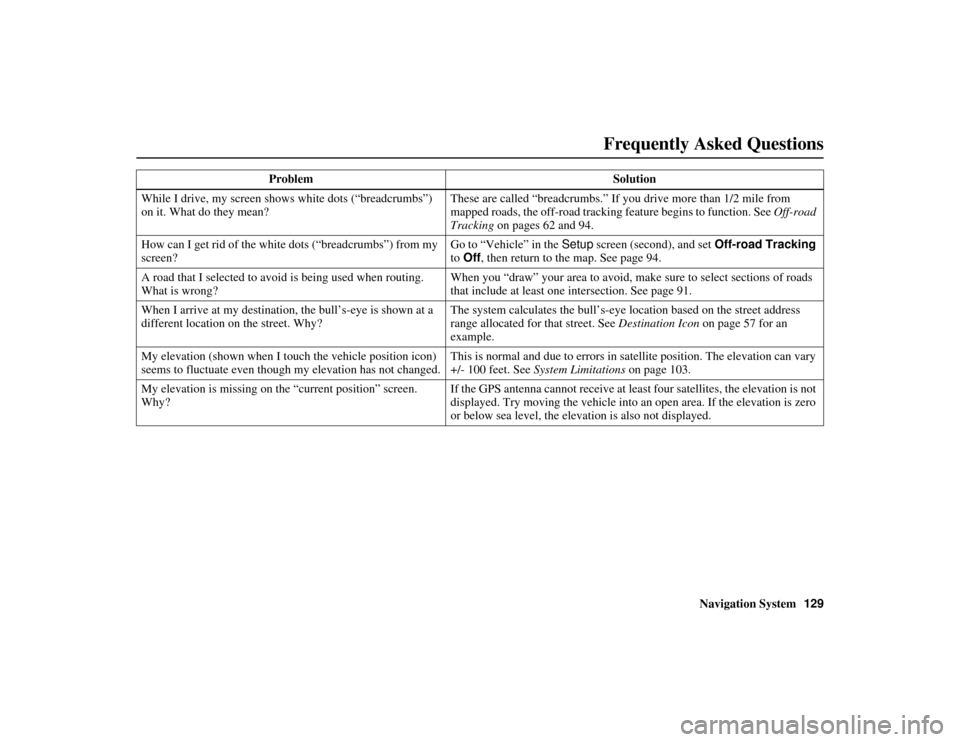
While I drive, my screen s hows white dots (“breadcrumbs”)
on it. What do they mean? These are called “breadcrumbs.” If yo
u drive more than 1/2 mile from
mapped roads, the off-road tracking feature begins to function. See Off-road
Tracking on pages 62 and 94.
How can I get rid of the white dots (“breadcrumbs”) from my
screen? Go to “Vehicle” in the
Setup screen (second), and set Off-road Tracking
to Off, then return to the map. See page 94.
A road that I selected to avoi d is being used when routing.
What is wrong? When you “draw” your area to avoid, make
sure to select sections of roads
that include at least one intersection. See page 91.
When I arrive at my destinati on, the bull’s-eye is shown at a
different location on the street. Why? The system calculates the bull’s-eye lo
cation based on the street address
range allocated for that street. See Destination Icon on page 57 for an
example.
My elevation (shown when I to uch the vehicle position icon)
seems to fluctuate even though my elevation has not changed. This is normal and due to errors in sa
tellite position. The elevation can vary
+/- 100 feet. See System Limitations on page 103.
My elevation is missing on th e “current position” screen.
Why? If the GPS antenna cannot r
eceive at least four satellites, the elevation is not
displayed. Try moving the vehicle into an open area. If the elevation is zero
or below sea level, the elevation is also not displayed.
Problem
Solution
Frequently Asked Questions
Page 132 of 152
Navigation System131
RIDGELINE KA 31SJC860
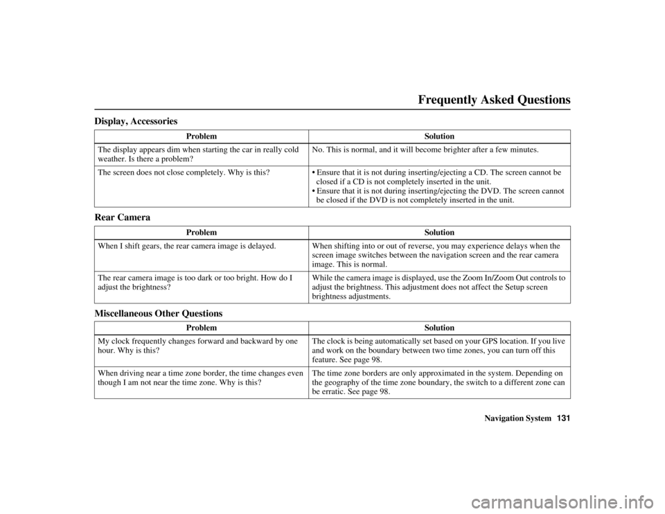
Display, Accessories
Rear Camera
Miscellaneous Other Questions
Problem Solution
The display appears dim when st arting the car in really cold
weather. Is there a problem? No. This is normal, and it will become brighter after a few minutes.
The screen does not close completely. Why is this? • Ensure that it is not during inserting/ejecting a CD. The screen cannot be
closed if a CD is not completely inserted in the unit.
• Ensure that it is not during inserti ng/ejecting the DVD. The screen cannot
be closed if the DVD is not completely inserted in the unit.
Problem Solution
When I shift gears, the rear camera image is delayed. When shifti ng into or out of reverse, you may experience delays when the
screen image switches between the na vigation screen and the rear camera
image. This is normal.
The rear camera image is too da rk or too bright. How do I
adjust the brightness? While the camera image is displayed, us
e the Zoom In/Zoom Out controls to
adjust the brightness. This adjustme nt does not affect the Setup screen
brightness adjustments.
Problem Solution
My clock frequently changes forward and backward by one
hour. Why is this? The clock is being automatically set based on your GPS location. If you live
and work on the boundary between two time zones, you can turn off this
feature. See page 98.
When driving near a time zone border, the time changes even
though I am not near the time zone. Why is this? The time zone borders are only approximated in the system. Depending on
the geography of the time zone boundary, the switch to a different zone can
be erratic. See page 98.
Frequently Asked Questions
Page 134 of 152
Navigation System133
RIDGELINE KA 31SJC860
Troubleshooting
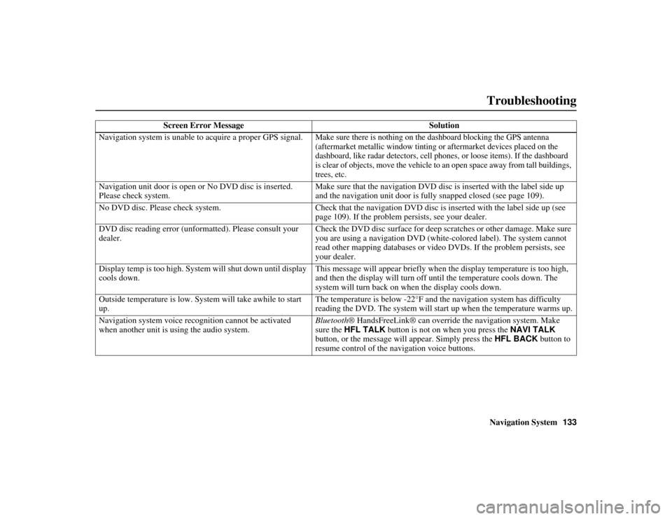
Screen Error Message Solution
Navigation system is unable to acquire a proper GPS signal.
Make sure there is nothing on the dashboard blocking the GPS antenna
(aftermarket metallic window tinting or aftermarket devices placed on the
dashboard, like radar detectors, cell phones, or loose items). If the dashboard
is clear of objects, move the vehicle to an open space away from tall buildings,
trees, etc.
Navigation unit door is open or No DVD disc is inserted.
Please check system. Make sure that the navigation DVD disc is inserted with the label side up
and the navigation unit door is fully snapped closed (see page 109).
No DVD disc. Please check system. Check that the navigation DVD disc is inserted with the label side up (see page 109). If the problem persists, see your dealer.
DVD disc reading error (unformatted). Please consult your
dealer. Check the DVD disc surface for deep scratches or other damage. Make sure
you are using a navigation DVD (white
-colored label). The system cannot
read other mapping databases or video DVDs. If the problem persists, see
your dealer.
Display temp is too high. System will shut down until display
cools down. This message will appear briefly when the display temperature is too high,
and then the display will turn off
until the temperature cools down. The
system will turn back on when the display cools down.
Outside temperature is low. System will take awhile to start
up. The temperature is below -22°F and the navigation system has difficulty
reading the DVD. The system will st
art up when the temperature warms up.
Navigation system voice recognition cannot be activated
when another unit is using the audio system. Bluetooth
® HandsFreeLink® can override the navigation system. Make
sure the HFL TALK button is not on when you press the NAVI TALK
button, or the message will appear. Simply press the HFL BACK button to
resume control of the navigation voice buttons.
Page 136 of 152
Navigation System135
RIDGELINE KA 31SJC860
Glossary
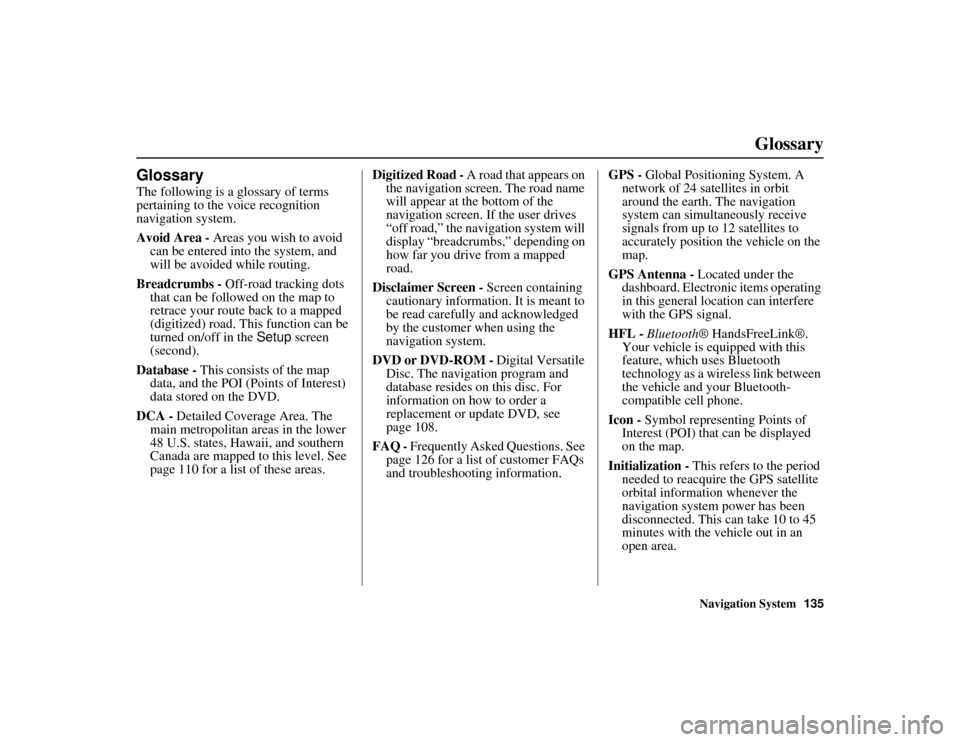
Glossary
The following is a glossary of terms
pertaining to the voice recognition
navigation system.
Avoid Area - Areas you wish to avoid
can be entered into the system, and
will be avoided while routing.
Breadcrumbs - Off-road tracking dots
that can be followed on the map to
retrace your route back to a mapped
(digitized) road. This function can be
turned on/off in the Setup screen
(second).
Database - This consists of the map
data, and the POI (Points of Interest)
data stored on the DVD.
DCA - Detailed Coverage Area. The
main metropolitan areas in the lower
48 U.S. states, Hawaii, and southern
Canada are mapped to this level. See
page 110 for a list of these areas. Digitized Road -
A road that appears on
the navigation screen. The road name
will appear at the bottom of the
navigation screen. If the user drives
“off road,” the navigation system will
display “breadcrumbs,” depending on
how far you drive from a mapped
road.
Disclaimer Screen - Screen containing
cautionary information. It is meant to
be read carefully and acknowledged
by the customer when using the
navigation system.
DVD or DVD-ROM - Digital Versatile
Disc. The navigation program and
database resides on this disc. For
information on how to order a
replacement or update DVD, see
page 108.
FAQ - Frequently Asked Questions. See
page 126 for a list of customer FAQs
and troubleshootin g information. GPS -
Global Positioning System. A
network of 24 satellites in orbit
around the earth. The navigation
system can simultaneously receive
signals from up to 12 satellites to
accurately position the vehicle on the
map.
GPS Antenna - Located under the
dashboard. Electronic items operating
in this general lo cation can interfere
with the GPS signal.
HFL - Bluetooth ® HandsFreeLink®.
Your vehicle is equipped with this
feature, which uses Bluetooth
technology as a wireless link between
the vehicle and your Bluetooth-
compatible cell phone.
Icon - Symbol representing Points of
Interest (POI) that can be displayed
on the map.
Initialization - This refers to the period
needed to reacquire the GPS satellite
orbital information whenever the
navigation system power has been
disconnected. This can take 10 to 45
minutes with the vehicle out in an
open area.
Page 137 of 152
136Navigation System
RIDGELINE KA 31SJC860
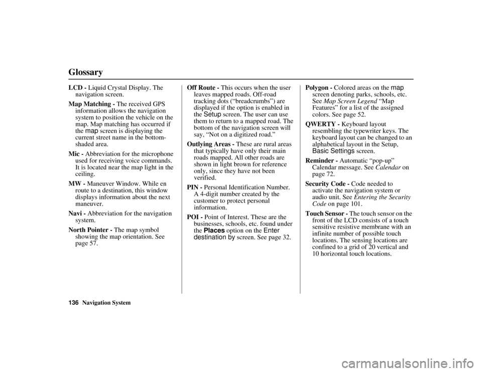
Glossary
LCD - Liquid Crystal Display. The
navigation screen.
Map Matching - The received GPS
information allows the navigation
system to position the vehicle on the
map. Map matching has occurred if
the map screen is displaying the
current street name in the bottom-
shaded area.
Mic - Abbreviation for the microphone
used for receiving voice commands.
It is located near the map light in the
ceiling.
MW - Maneuver Window. While en
route to a destination, this window
displays informatio n about the next
maneuver.
Navi - Abbreviation for the navigation
system.
North Pointer - The map symbol
showing the map orientation. See
page 57. Off Route -
This occurs when the user
leaves mapped roads. Off-road
tracking dots (“breadcrumbs”) are
displayed if the option is enabled in
the Setup screen. The user can use
them to return to a mapped road. The
bottom of the navigation screen will
say, “Not on a digitized road.”
Outlying Areas - These are rural areas
that typically have only their main
roads mapped. All other roads are
shown in light brown for reference
only, since they have not been
verified.
PIN - Personal Identification Number.
A 4-digit number created by the
customer to protect personal
information.
POI - Point of Interest. These are the
businesses, schools, etc. found under
the Places option on the Enter
destination by screen. See page 32. Polygon -
Colored areas on the map
screen denoting parks, schools, etc.
See Map Screen Legend “Map
Features” for a list of the assigned
colors. See page 52.
QWERTY - Keyboard layout
resembling the typewriter keys. The
keyboard layout can be changed to an
alphabetical layou t in the Setup,
Basic Settings screen.
Reminder - Automatic “pop-up”
Calendar message. See Calendar on
page 72.
Security Code - Code needed to
activate the navigation system or
audio unit. See Entering the Security
Code on page 101.
Touch Sensor - The touch sensor on the front of the LCD consists of a touch
sensitive resistive me mbrane with an
infinite number of possible touch
locations. The sensing locations are
confined to a grid of 20 vertical and
10 horizontal touch locations.
Page 139 of 152
138Navigation System
RIDGELINE KA 31SJC860
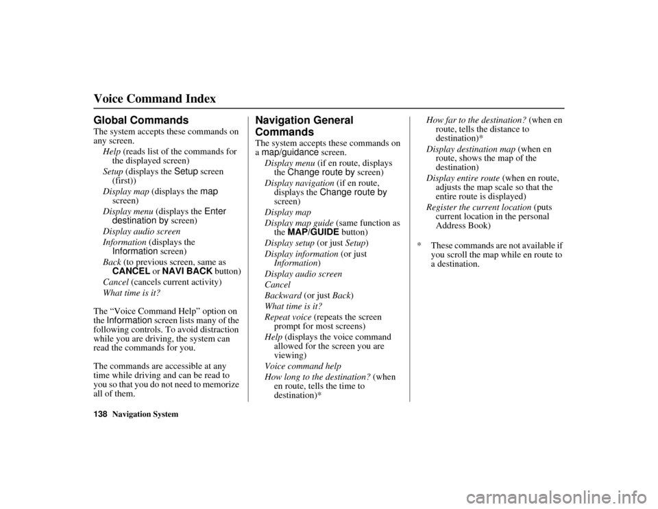
Voice Command Index
Global Commands
The system accepts these commands on
any screen.Help (reads list of the commands for
the displayed screen)
Setup (displays the Setup screen
(first))
Display map (displays the map
screen)
Display menu (displays the Enter
destination by screen)
Display audio screen
Information (displays the
Information screen)
Back (to previous screen, same as
CANCEL or NAVI BACK button)
Cancel (cancels current activity)
What time is it?
The “Voice Command Help” option on
the Information screen lists many of the
following controls. To avoid distraction
while you are driving, the system can
read the commands for you.
The commands are accessible at any
time while driving and can be read to
you so that you do not need to memorize
all of them.
Navigation General
Commands
The system accepts these commands on
a map/guidance screen.
Display menu (if en route, displays
the Change route by screen)
Display navigation (if en route,
displays the Change route by
screen)
Display map
Display map guide (same function as
the MAP/GUIDE button)
Display setup (or just Setup)
Display information (or just
Information )
Display audio screen
Cancel
Backward (or just Back )
What time is it?
Repeat voice (repeats the screen
prompt for most screens)
Help (displays the voice command
allowed for the screen you are
viewing)
Voice command help
How long to the destination? (when
en route, tells the time to
destination)* How far to the destination?
(when en
route, tells the distance to
destination)*
Display destination map (when en
route, shows the map of the
destination)
Display entire route (when en route,
adjusts the map scale so that the
entire route is displayed)
Register the current location (puts
current location in the personal
Address Book)
* These commands are not available if you scroll the map while en route to
a destination.