tow HONDA RIDGELINE 2013 1.G Navigation Manual
[x] Cancel search | Manufacturer: HONDA, Model Year: 2013, Model line: RIDGELINE, Model: HONDA RIDGELINE 2013 1.GPages: 152, PDF Size: 4.14 MB
Page 8 of 152
Navigation System7
RIDGELINE KA 31SJC860
Introduction
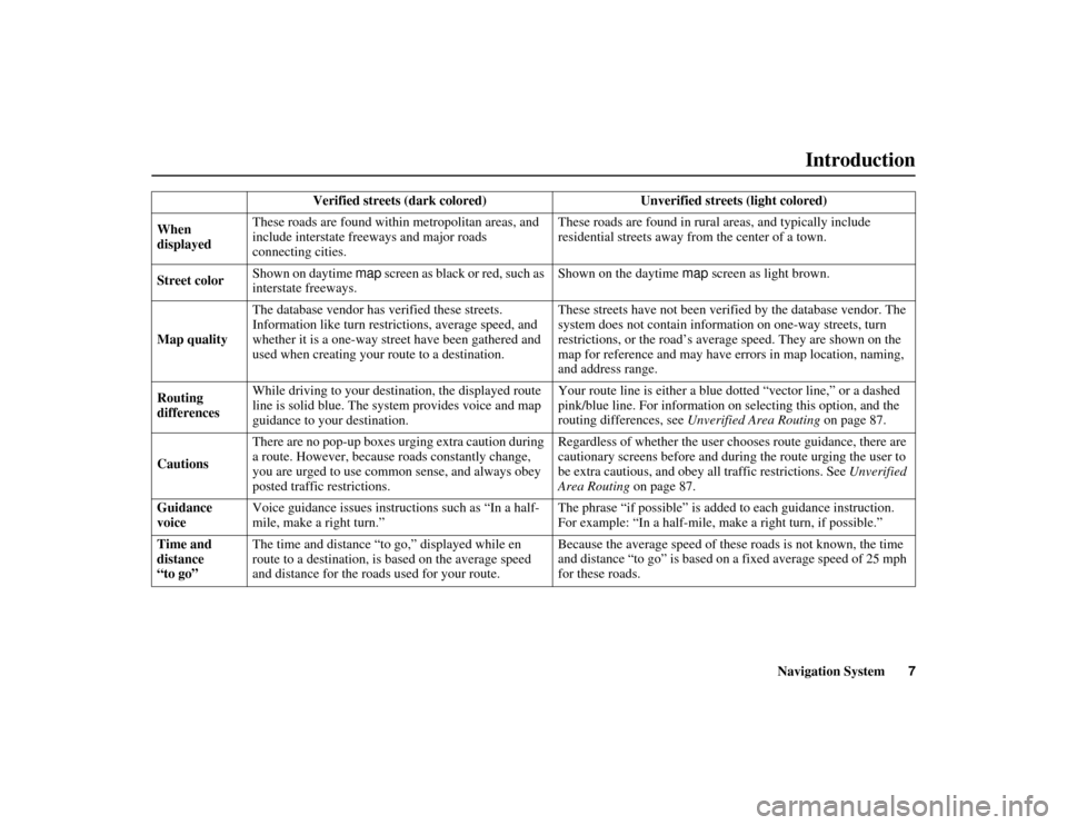
Verified streets (dark colored) Unverified streets (light colored)
When
displayed These roads are found within
metropolitan areas, and
include interstate fr eeways and major roads
connecting cities. These roads are found in rura
l areas, and typically include
residential streets away fr om the center of a town.
Street color Shown on daytime map
screen as black or red, such as
interstate freeways. Shown on the daytime
map screen as light brown.
Map quality The database vendor has verified these streets.
Information like turn restrictions, average speed, and
whether it is a one-way str
eet have been gathered and
used when creating your route to a destination. These streets have not been verifi
ed by the database vendor. The
system does not contain information on one-way streets, turn
restrictions, or the road’s aver age speed. They are shown on the
map for reference and may have errors in map location, naming,
and address range.
Routing
differences While driving to your destination, the displayed route
line is solid blue. The system provides voice and map
guidance to your destination. Your route line is either a blue
dotted “vector line,” or a dashed
pink/blue line. For information on selecting this option, and the
routing differences, see Unverified Area Routing on page 87.
Cautions There are no pop-up boxes urging extra caution during
a route. However, because
roads constantly change,
you are urged to use common sense, and always obey
posted traffic restrictions. Regardless of whether the user ch
ooses route guidance, there are
cautionary screens before and durin g the route urging the user to
be extra cautious, and obey a ll traffic restrictions. See Unverified
Area Routing on page 87.
Guidance
voice Voice guidance issues instruc
tions such as “In a half-
mile, make a right turn.” The phrase “if possible” is adde
d to each guidance instruction.
For example: “In a half-mile, ma ke a right turn, if possible.”
Time and
distance
“to go” The time and distance “to go,” displayed while en
route to a destination, is
based on the average speed
and distance for the road s used for your route. Because the average speed of thes
e roads is not known, the time
and distance “to go” is based on a fixed average speed of 25 mph
for these roads.
Page 26 of 152
Navigation System25
RIDGELINE KA 31SJC860
If the system does not find an exact
match, select List when you finish
entering the name of the city. Most of
the cities and towns for that state are
listed.
Listings of cities and towns in the non-
detailed coverage area may have an
asterisk “*” next to their names. If you
select one, a pop-up box is displayed
saying, “No detailed street data...”, and
a street address cannot be entered (see
Map Coverage on page 110). Try
entering the street first, and then select
the city if available.
Select View Dest. Map and use the
joystick to select an icon, approximate
area, or street you wish to choose as
your destination. Otherwise, a central
location of the city will be selected. If
you select a point of interest (POI) or
road in an unverified area, you may or
may not have routing in these areas. See
Map Overview on page 6.Selecting the Street
By Voice Control:
After you have selected the city, or if
you say “Street” on the Find address
by screen, the display changes to the
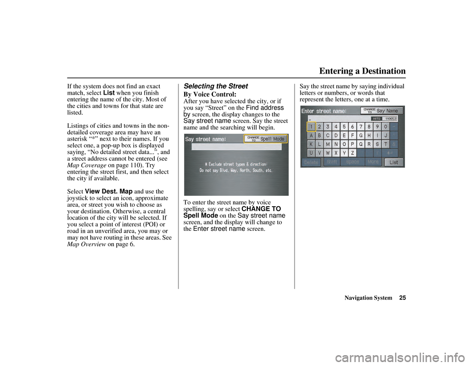
Say street name screen. Say the street
name and the searching will begin.
To enter the street name by voice
spelling, say or select CHANGE TO
Spell Mode on the Say street name
screen, and the display will change to
the Enter street name screen. Say the street name by saying individual
letters or numbers, or words that
represent the letters, one at a time.
Entering a Destination
Page 30 of 152
Navigation System29
RIDGELINE KA 31SJC860
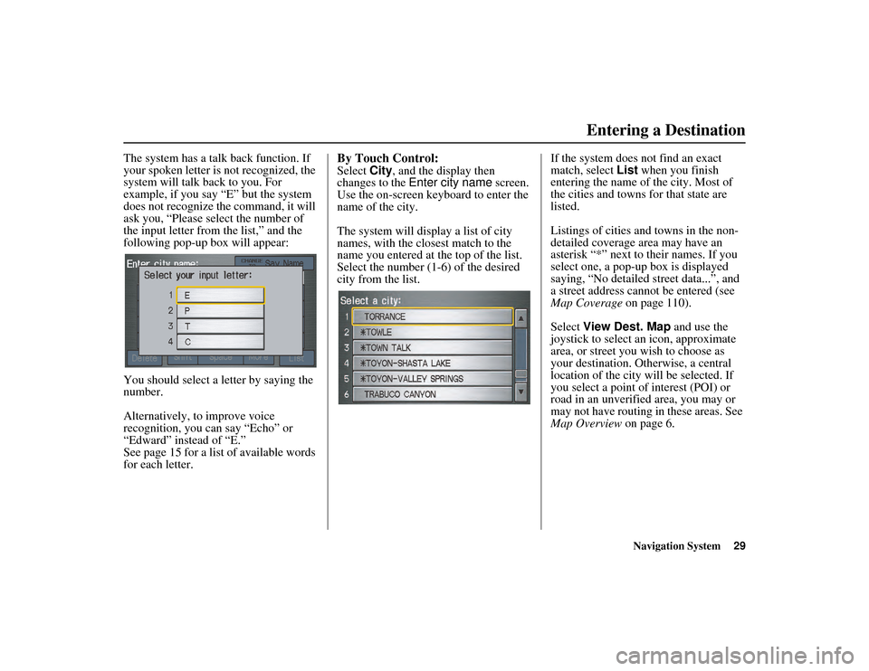
The system has a talk back function. If
your spoken letter is not recognized, the
system will talk ba ck to you. For
example, if you say “E” but the system
does not recognize the command, it will
ask you, “Please select the number of
the input letter from the list,” and the
following pop-up box will appear:
You should select a letter by saying the
number.
Alternatively, to improve voice
recognition, you can say “Echo” or
“Edward” instead of “E.”
See page 15 for a list of available words
for each letter.By Touch Control:
Select City, and the display then
changes to the Enter city name screen.
Use the on-screen keyboard to enter the
name of the city.
The system will display a list of city
names, with the closest match to the
name you entered at the top of the list.
Select the number (1-6) of the desired
city from the list. If the system does not find an exact
match, select
List when you finish
entering the name of the city. Most of
the cities and towns for that state are
listed.
Listings of cities and towns in the non-
detailed coverage area may have an
asterisk “*” next to their names. If you
select one, a pop-up box is displayed
saying, “No detailed street data...”, and
a street address cannot be entered (see
Map Coverage on page 110).
Select View Dest. Map and use the
joystick to select an icon, approximate
area, or street you wish to choose as
your destination. Otherwise, a central
location of the city will be selected. If
you select a point of interest (POI) or
road in an unverified area, you may or
may not have routing in these areas. See
Map Overview on page 6.
Entering a Destination
Page 114 of 152
Navigation System113
RIDGELINE KA 31SJC860
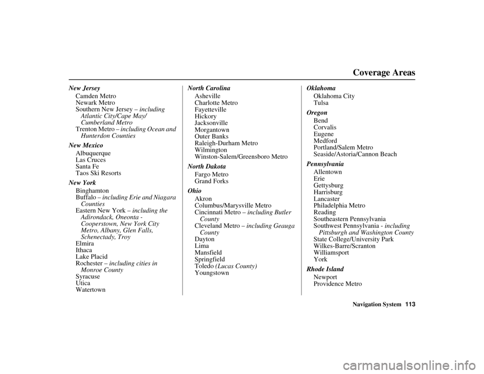
Coverage Areas
New Jersey
Camden Metro
Newark Metro
Southern New Jersey – including
Atlantic City/Cape May/
Cumberland Metro
Trenton Metro – including Ocean and
Hunterdon Counties
New Mexico Albuquerque
Las Cruces
Santa Fe
Taos Ski Resorts
New York Binghamton
Buffalo – including Erie and Niagara
Counties
Eastern New York – including the
Adirondack, Oneonta -
Cooperstown, Ne w York City
Metro, Albany, Glen Falls,
Schenectady, Troy
Elmira
Ithaca
Lake Placid
Rochester – including cities in
Monroe County
Syracuse
Utica
Watertown North Carolina
Asheville
Charlotte Metro
Fayetteville
Hickory
Jacksonville
Morgantown
Outer Banks
Raleigh-Durham Metro
Wilmington
Winston-Salem/Greensboro Metro
North Dakota Fargo Metro
Grand Forks
Ohio Akron
Columbus/Marysville Metro
Cincinnati Metro – including Butler
County
Cleveland Metro – including Geauga
County
Dayton
Lima
Mansfield
Springfield
Toledo (Lucas County)
Youngstown Oklahoma
Oklahoma City
Tulsa
Oregon Bend
Corvalis
Eugene
Medford
Portland/Salem Metro
Seaside/Astoria/Cannon Beach
Pennsylvania Allentown
Erie
Gettysburg
Harrisburg
Lancaster
Philadelphia Metro
Reading
Southeastern Pennsylvania
Southwest Pennsylvania - including
Pittsburgh and Wa shington County
State College/University Park
Wilkes-Barre/Scranton
Williamsport
York
Rhode Island Newport
Providence Metro
Page 116 of 152
Navigation System115
RIDGELINE KA 31SJC860
Coverage Areas
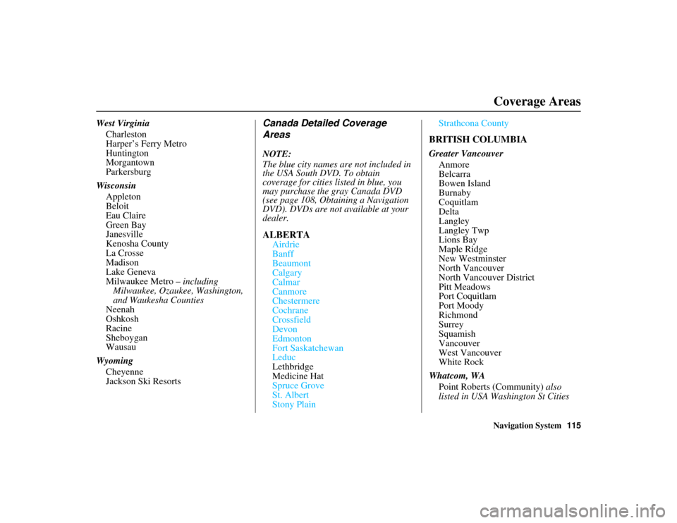
West Virginia
Charleston
Harper’s Ferry Metro
Huntington
Morgantown
Parkersburg
Wisconsin Appleton
Beloit
Eau Claire
Green Bay
Janesville
Kenosha County
La Crosse
Madison
Lake Geneva
Milwaukee Metro – including Milwaukee, Ozaukee, Washington,
and Waukesha Counties
Neenah
Oshkosh
Racine
Sheboygan
Wausau
Wyoming Cheyenne
Jackson Ski ResortsCanada Detailed Coverage
Areas
NOTE:
The blue city names are not included in
the USA South DVD. To obtain
coverage for cities listed in blue, you
may purchase the gray Canada DVD
(see page 108, Obtaining a Navigation
DVD). DVDs are not available at your
dealer.
ALBERTA
Airdrie
Banff
Beaumont
Calgary
Calmar
Canmore
Chestermere
Cochrane
Crossfield
Devon
Edmonton
Fort Saskatchewan
Leduc
Lethbridge
Medicine Hat
Spruce Grove
St. Albert
Stony Plain Strathcona County
BRITISH COLUMBIA
Greater Vancouver
Anmore
Belcarra
Bowen Island
Burnaby
Coquitlam
Delta
Langley
Langley Twp
Lions Bay
Maple Ridge
New Westminster
North Vancouver
North Vancouver District
Pitt Meadows
Port Coquitlam
Port Moody
Richmond
Surrey
Squamish
Vancouver
West Vancouver
White Rock
Whatcom, WA Point Roberts (Community) also
listed in USA Washington St Cities
Page 118 of 152
Navigation System117
RIDGELINE KA 31SJC860
Coverage Areas
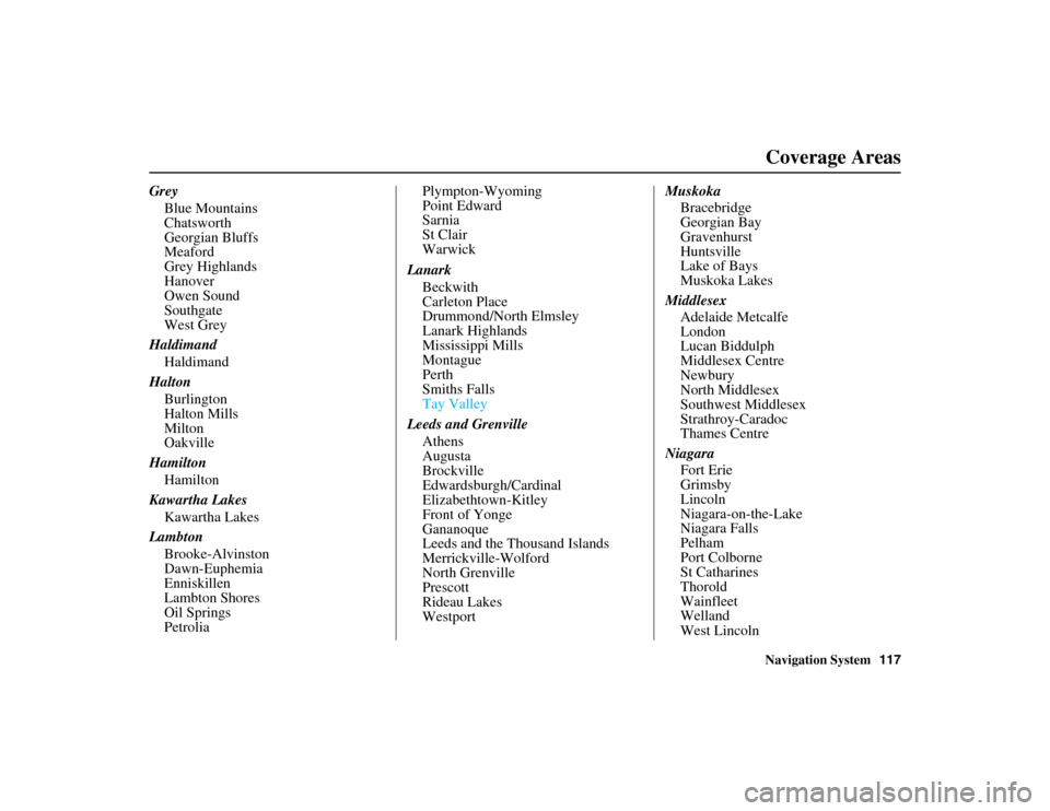
Grey
Blue Mountains
Chatsworth
Georgian Bluffs
Meaford
Grey Highlands
Hanover
Owen Sound
Southgate
West Grey
Haldimand Haldimand
Halton Burlington
Halton Mills
Milton
Oakville
Hamilton Hamilton
Kawartha Lakes Kawartha Lakes
Lambton Brooke-Alvinston
Dawn-Euphemia
Enniskillen
Lambton Shores
Oil Springs
Petrolia Plympton-Wyoming
Point Edward
Sarnia
St Clair
Warwick
Lanark Beckwith
Carleton Place
Drummond/North Elmsley
Lanark Highlands
Mississippi Mills
Montague
Perth
Smiths Falls
Tay Valley
Leeds and Grenville Athens
Augusta
Brockville
Edwardsburgh/Cardinal
Elizabethtown-Kitley
Front of Yonge
Gananoque
Leeds and the Thousand Islands
Merrickville-Wolford
North Grenville
Prescott
Rideau Lakes
Westport Muskoka
Bracebridge
Georgian Bay
Gravenhurst
Huntsville
Lake of Bays
Muskoka Lakes
Middlesex Adelaide Metcalfe
London
Lucan Biddulph
Middlesex Centre
Newbury
North Middlesex
Southwest Middlesex
Strathroy-Caradoc
Thames Centre
Niagara Fort Erie
Grimsby
Lincoln
Niagara-on-the-Lake
Niagara Falls
Pelham
Port Colborne
St Catharines
Thorold
Wainfleet
Welland
West Lincoln
Page 120 of 152
Navigation System119
RIDGELINE KA 31SJC860
Coverage Areas
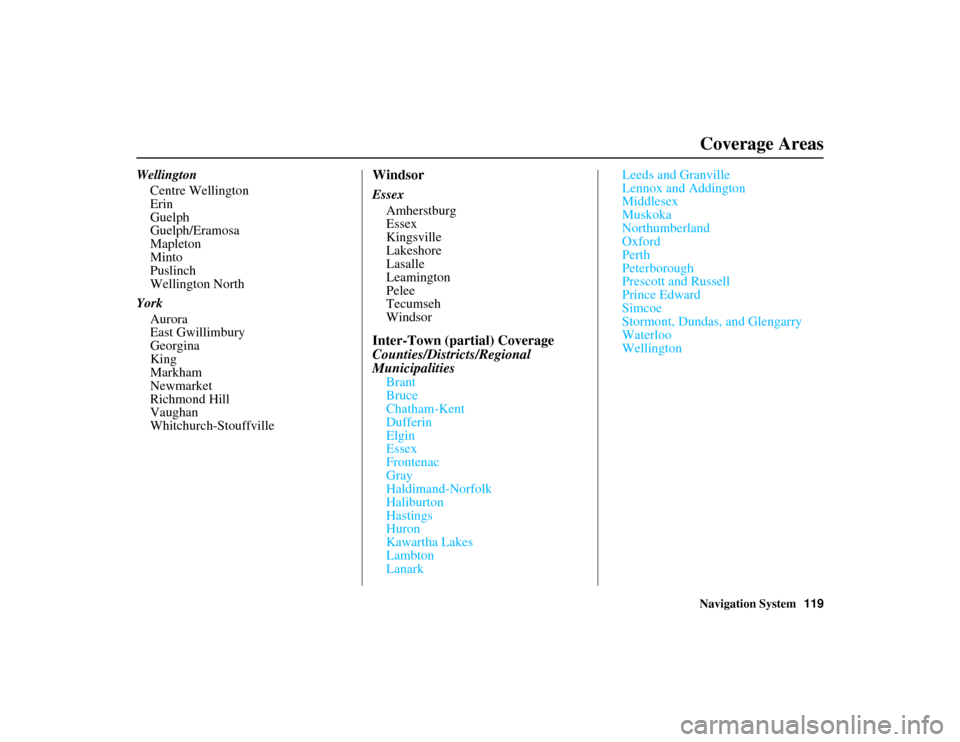
Wellington
Centre Wellington
Erin
Guelph
Guelph/Eramosa
Mapleton
Minto
Puslinch
Wellington North
York Aurora
East Gwillimbury
Georgina
King
Markham
Newmarket
Richmond Hill
Vaughan
Whitchurch-StouffvilleWindsor
EssexAmherstburg
Essex
Kingsville
Lakeshore
Lasalle
Leamington
Pelee
Tecumseh
Windsor
Inter-Town (partial) Coverage
Counties/Districts/Regional
Municipalities
Brant
Bruce
Chatham-Kent
Dufferin
Elgin
Essex
Frontenac
Gray
Haldimand-Norfolk
Haliburton
Hastings
Huron
Kawartha Lakes
Lambton
Lanark Leeds and Granville
Lennox and Addington
Middlesex
Muskoka
Northumberland
Oxford
Perth
Peterborough
Prescott and Russell
Prince Edward
Simcoe
Stormont, Dundas, and Glengarry
Waterloo
Wellington
Page 121 of 152
120Navigation System
RIDGELINE KA 31SJC860
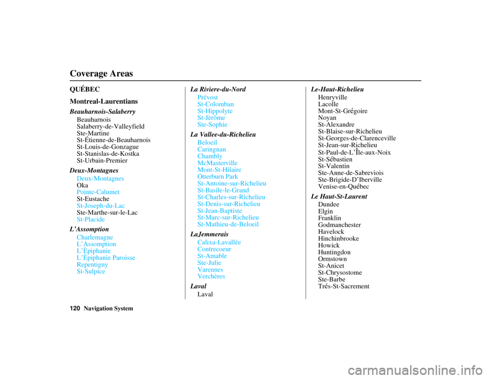
QUÉBEC
Montreal-Laurentians
Beauharnois-SalaberryBeauharnois
Salaberry-de-Valleyfield
Ste-Martine
St-Étienne-de-Beauharnois
St-Louis-de-Gonzague
St-Stanislas-de-Kostka
St-Urbain-Premier
Deux-Montagnes Deux-Montagnes
Oka
Pointe-Calumet
St-Eustache
St-Joseph-du-Lac
Ste-Marthe-sur-le-Lac
St-Placide
L’Assomption Charlemagne
L’Assomption
L’Èpiphanie
L’Èpiphanie Paroisse
Repentigny
St-Sulpice La Rivìere-du-Nord
Prévost
St-Colomban
St-Hippolyte
St-Jèrôme
Ste-Sophie
La Vallee-du-Richelieu Beloeil
Caringnan
Chambly
McMasterville
Mont-St-Hilaire
Otterburn Park
St-Antoine-sur-Richelieu
St-Basile-le-Grand
St-Charles-sur-Richelieu
St-Denis-sur-Richelieu
St-Jean-Baptiste
St-Marc-sur-Richelieu
St-Mathieu-de-Beloeil
LaJemmerais Calixa-Lavallée
Contrecoeur
St-Amable
Ste-Julie
Varennes
Verchères
Laval Laval Le-Haut-Richelieu
Henryville
Lacolle
Mont-St-Grégoire
Noyan
St-Alexandre
St-Blaise-sur-Richelieu
St-Georges-de-Clarenceville
St-Jean-sur-Richelieu
St-Paul-de-L’
Île-aux-Noix
St-S
ébastien
St-Valentin
Ste-Anne-de-Sabreviois
Ste-Brigide-D’Iberville
Venise-en-Qu
ébec
Le Haut-St-Laurent Dundee
Elgin
Franklin
Godmanchester
Havelock
Hinchinbrooke
Howick
Huntingdon
Ormstown
St-Anicet
St-Chrysostome
Ste-Barbe
Tr
és-St-Sacrement
Coverage Areas
Page 125 of 152
124Navigation System
RIDGELINE KA 31SJC860
Coverage Areas
Operation in Alaska and
Hawaii
Certain functions that rely on a satellite
signal will not work correctly in Alaska
and Hawaii. These functions include but
are not limited to XM radio, automatic
clock updates, and time zone
adjustments.
Alaska
If the vehicle was purchased in the
lower 48 states and driven to Alaska, the
system cannot display maps. The
message “Vehicle is out of the
database...” will be displayed.
Hawaii
This section describes the differences in
navigation system operation for vehicles
delivered in Hawaii.
XM Radio
Navigation-equipped vehicles delivered
to Hawaii are equipped with XM
hardware, but XM broadcasting is not
available; therefore sections of the
manual that mention XM audio do not
apply. Vehicles originally delivered to
the U.S. mainland and shipped to Hawaii
also have XM, but will not function
because the XM satellites (aimed toward
the U.S. mainland) are too far away to
obtain reception.
Map Coverage
All roads displayed on the Hawaii map
screens are detailed coverage roads.
Text related to “unverified” roads or
areas are not applicable. The following
topics do not apply in Hawaii:
• Unverified road descriptions (see page 6 and 87).
• Cautions and pop-up windows related to unverified roads (see page 64). • Setup entries that relate to turning on
or off unverified routing (see
page 87).
• When zooming in and out, there is no 350-mile scale for Hawaii.
Other Map Issues
• See the coverage se ction for a list of
islands with coverage (see page 110).
• Freeway Exit information does not exist in Hawaii, so the “Freeway Exit
Info” icon is not shown on the icon
bar.
Page 138 of 152
Navigation System137
RIDGELINE KA 31SJC860
Glossary
Unverified Streets - These streets have
not been verified fo r turn restrictions,
one-way, etc. They are shown in light
brown on the map. Unverified streets
may be missing from the map, shown
in the wrong location, or have an
incorrect name or address range.
Vehicle Speed Sensor - Provides speed
signal to the navigation system for
moving the VP icon on the map.
Verified Streets - These streets consist
of the detailed metr opolitan coverage
areas and all other inter-town
connection roads. These roads are
shown in black on the map.
Voice Control - See VR.
VP - Vehicle Position. When in map
mode, this circular icon shows the
vehicle position on the map. Touch
this icon to show the latitude,
longitude, and elevation of your
current position. VR -
Voice Recognition. This allows
voice control of many of the
navigation functions. The hardware
consists of the microphone, voice
control switch ( NAVI TALK/NAVI
BACK buttons), and the front
speakers.
Waypoint - A temporary destination
you may enter while en route (e.g., a
gas station, ATM, etc.). See page 65.
Yaw Rate Sensor - Senses when the
vehicle makes a turn, which makes
the VP change direction on the map
as you turn.
Zagat Ratings - Restaurant ratings
information provided by Zagat
Survey. See the Information screen
on page 76 for an explanation of the
ratings.