sensor INFINITI QX60 2014 Navigation Manual
[x] Cancel search | Manufacturer: INFINITI, Model Year: 2014, Model line: QX60, Model: INFINITI QX60 2014Pages: 267, PDF Size: 3.09 MB
Page 162 of 267

7. Viewing technical information
7-16
VIEWING AVAILABLE TRAFFIC INFORMA-
TION
NavTraffic information is a subscription
service offered by SiriusXM Satellite Radio.
This service provides real-time information
regarding traffic flow, accidents, road
construction and other incidents, where
available.
NavTraffic combines information from com-
mercial and public traffic data providers
including government departments of
transportation, police, emergency services,
road sensors, cameras and aircraft reports.
The traffic information is broadcast to the
vehicle by the SiriusXM satellites. Avail-
able traffic information on the route the
driver selected is shown on the navigation
screen so traffic conditions between you
and the destination are known. Three types
of real-time traffic information for major
roadways are shown on the navigation
system:
* Unscheduled traffic data for example,
accidents and disabled vehicles.
* Scheduled traffic data, for example road
construction and road closures.
* Traffic flow information (rate of speeddata).WARNING!
NavTraffic information is not a substitute for
attentive driving. Traffic conditions change
constantly and emergency situations can
arise without warning. Relying only on
NavTraffic information may lead to a collision
and could result in serious personal injury.
NOTE:
Flow information is provided only for roads
equipped with traffic sensors and is not
available in all markets covered by the service.
Flow data may not be available on portions of a
road that is under construction.
NavTraffic information is available in lim-
ited markets. To subscribe or to check if
this service is available in the area:
call 1-866-635-2349 or see www.siriusxm.
com/navtraffic
INFO:
If a contract is not completed for NavTraffic
traffic information service, a message appears,
and it will not be possible to check the
information on the traffic information system.
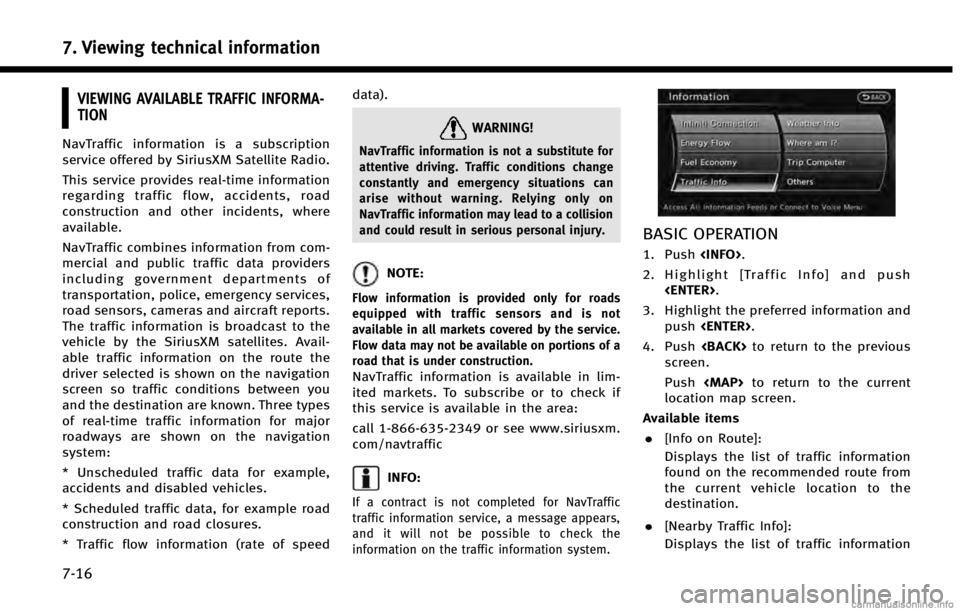
BASIC OPERATION
1. Push
2. Highlight [Traffic Info] and push
3. Highlight the preferred information and push
4. Push
screen.
Push
Page 224 of 267

10. General system information
10-4
CURRENT VEHICLE LOCATION
DISPLAY OF CURRENT VEHICLE LO-
CATION
This navigation system combines the data
obtained from the vehicle (by gyro sensor)
and from GPS (Global Positioning System)
satellites to calculate the current location
of the vehicle. This position is then
displayed throughout route guidance to a
destination.
WHAT IS GPS (Global Positioning
System)?
GPS is a position detecting system that
uses satellites deployed by the U.S.
government. This navigation system re-
ceives radio signals from three or more
different satellites that orbit 13,049 miles
(21,000 km) above the earth in space, and
detects the position of the vehicle by
utilizing the principle of triangulation.
Positioning adjustment
When the system judges that the vehicle
position information is not accurate based
on vehicle speed and gyro sensor data
calculations, the system will automatically
adjust the position of the vehicle iconusing GPS signals.
Receiving signals from GPS satel-
lites
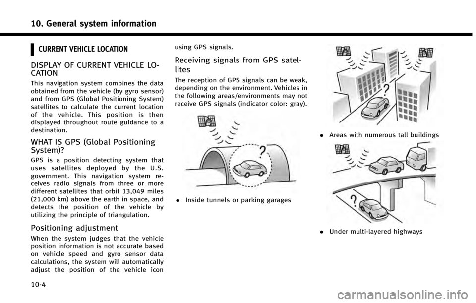
The reception of GPS signals can be weak,
depending on the environment. Vehicles in
the following areas/environments may not
receive GPS signals (indicator color: gray).
.
Inside tunnels or parking garages
.Areas with numerous tall buildings
.Under multi-layered highways
Page 235 of 267

provided. All fees and programming are
subject to change. For more details on
the NavTraffic service, terms and con-
ditions, please visit
www.siriusxm.com/navtraffic.
You can also contact SiriusXM Satellite
Radio at 1-866-635-2349.
. As of January 31, 2009, the NavTraffic
service covers 80 major metropolitan
markets. For the most current list of
markets covered, please refer to www.
siriusxm.com/navtraffic, or call Sir-
iusXM Satellite Radio customer support
at 1-866-635-2349.
. Due to road maintenance, infrastruc-
ture problems (e.g. malfunction of road
sensors, outage of central computer of
infrastructure) or natural disasters,
there are times when some or all traffic
information may not be available.
. Incident information is based on hu-
man collection. Not all incidents that
have happened are collected and pro-
vided.
. Due to infrastructure problems, or
transmission delay, there are times
when the information may differ from
the actual condition. Always observe safe driving practices and follow all
traffic regulations.
. Due to the coverage and quality of
traffic information and road conditions,
it is not always possible for the system
to provide the shortest time route even
when traffic information is considered.
. Traffic information that is displayed
may differ from information from other
media (e.g., radio), as other media may
use different information sources.
. If the Infiniti Connection (if so
equipped) Text-to-Speech function is
used after downloading information
feeds immediately after the navigation
system is started up, it may take some
time until the NavTraffic information is
displayed on the screen.NOTES ON NavWeatherXM INFORMA-
TION
.The NavWeatherXM information service
is not provided for some cities. In
addition, the cities for which the weath-
er information service is provided may
be changed.
. In some cases, infrastructure problems
may prevent the complete display of
the weather information. This is not a
malfunction.
. Due to infrastructure problems, or due
to the time when the weather informa-
tion service broadcast is received, the
displayed information may differ from
the actual weather conditions.
. NavWeatherXM is a service of SiriusXM
Satellite Radio. NavWeatherXM is only
available in select markets and is
subject to data availability. Reception
of the SiriusXM signal may vary de-
pending on location. It requires a
monthly premium subscription. The
service provider is solely responsible
for the quality and accuracy of the
information provided. All fees and
programming are subject to change.
10. General system information
10-15
Page 247 of 267

SymptomPossible cause Possible solution
The GPS indicator on the screen remains gray. GPS signals cannot be received under certain conditions, such as in a parking garage, on a road with many tall buildings, etc. Drive on an open, straight road for a while.
GPS signals cannot be received because objects are placed on the
instrument panel. Remove the objects from the instrument
panel.
A sufficient number of GPS satellites is not available. Wait for the satellites to move to locations
available for the navigation system.
The location of the vehicle icon is misaligned
from the actual position. When using tire chains or replacing the tires, speed calculations
based on the speed sensor may be incorrect. Drive the vehicle for about 30 minutes at
approximately 19 MPH (30 km/h) to auto-
matically correct the vehicle icon position.
If this does not correct the vehicle icon
position, contact an INFINITI retailer.
The map data has a mistake or is incomplete (the vehicle icon
position is always misaligned in the same area). Updated road information will be included
in the next version of the map data.
11. Troubleshooting guide
11-5