dimensions KIA NIRO EV 2020 Navigation System Quick Reference Guide
[x] Cancel search | Manufacturer: KIA, Model Year: 2020, Model line: NIRO EV, Model: KIA NIRO EV 2020Pages: 244, PDF Size: 5.65 MB
Page 10 of 244

8
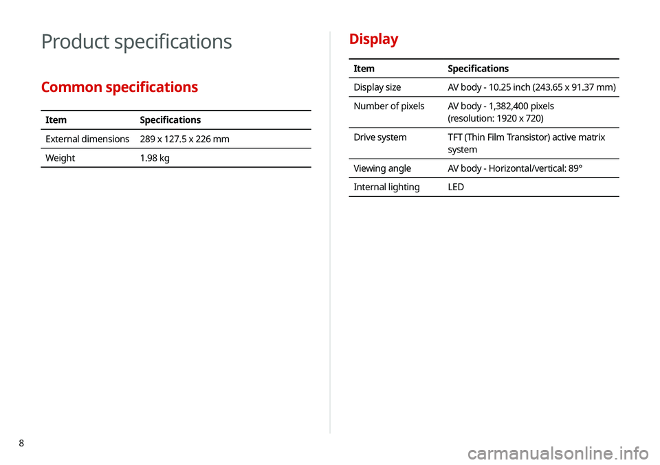
Display
ItemSpecifications
Display size AV body - 10.25 inch (243.65 x 91.37 mm)
Number of pixels AV body - 1,382,400 pixels
(resolution: 1920 x 720)
Drive system TFT (Thin Film Transistor) active matrix
system
Viewing angle AV body - Horizontal/vertical: 89°
Internal lighting LED
Product specifications
Common specifications
ItemSpecifications
External dimensions 289 x 127.5 x 226 mm
Weight 1.98 kg
Page 41 of 244

2-3
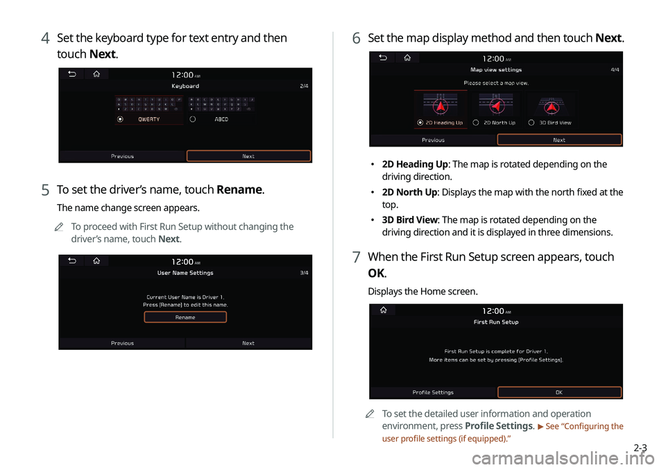
4 Set the keyboard type for text entry and then
touch Next.
5 To set the driver’s name, touch Rename.
The name change screen appears.
0000
A
To proceed with First Run Setup without changing the
driver’s name, touch Next.
6 Set the map display method and then touch Next.
000E2D Heading Up: The map is rotated depending on the
driving direction.
000E2D North Up: Displays the map with the north fixed at the
top.
000E3D Bird View: The map is rotated depending on the
driving direction and it is displayed in three dimensions.
7 When the First Run Setup screen appears, touch
OK.
Displays the Home screen.
0000A
To set the detailed user information and operation
environment, press Profile Settings.
> See “Configuring the
user profile settings (if equipped).”
Page 200 of 244

9-18
000EDetailed Guidance View: You can set to display detailed
information on the Map screen, such as moving directions
and lane change.
000ESpeed Limits: Sets whether or not to display the speed limits
on the screen.
Map Auto-scale Settings
You can set the scales for each vehicle speed zone.
0000
A
For example, when you select “100 m” for the “21–50 km/h”
zone and “200 m” for the “51–80 km/h” zone, the unit interval
for the map scale on the navigation screen becomes 100
m when the vehicle speed is 50 km/h and 200 m when the
vehicle speed is 51 km/h.
Return to Map: Set Time
You can set the system to automatically display the map screen
after a specified period of time when switched to the Radio/Media
mode screen while using the navigation.
> See “Return to Map: Set
Time.”
0000
A
This function works while driving once a destination has been
set.
0000
A
This feature is not available on the phone projection screen.
Auto Re-center Map
You can set the system to automatically display the current
position when the specified period of time elapses after changing
to another position on the map.
000DDisplay Traffic: Displays nearby traffic information on the
map.
000D3D Buildings: Displays major buildings on the map in
three dimensions.
000DAuto-scale: Automatically changes the scale of the map.
000E POI Display: You can specify the icon type to display nearby
places on the map.
0000
A
Touch
on the right side of Gas/LPG Station to select display
options for fuel prices.
000DGas and LPG stations on the Map screen will also show their
fuel prices if they are lower than the set price.
000DSelect Display Fuel Price Info on Map to view
recommended fuel prices based on the prices offered in
the area.
000DFuel prices on the map may differ from actual ones.
Information
You can specify the information to display on the navigation map
screen while driving.
000E Route Guide Line: Used to display the route guide line in
different colors depending on the traffic conditions. To display
the route color with a fixed one, uncheck Show Traffic Colors
on Route and select a color.
000EVehicle Symbol: You can specify the icon type to display your
current location on the map.
000EUnit: You can set the distance unit of the navigation map to
Kilometers (km) or Miles (mi) (if equipped).
000EShow Vehicle Speed: Displays the vehicle speed on the map.