display MAZDA MODEL MAZDASPEED 6 2007 (in English) Workshop Manual
[x] Cancel search | Manufacturer: MAZDA, Model Year: 2007, Model line: MODEL MAZDASPEED 6, Model: MAZDA MODEL MAZDASPEED 6 2007Pages: 413, PDF Size: 10.97 MB
Page 394 of 413
37
Before
UseGetting
startedRouting
Address Book
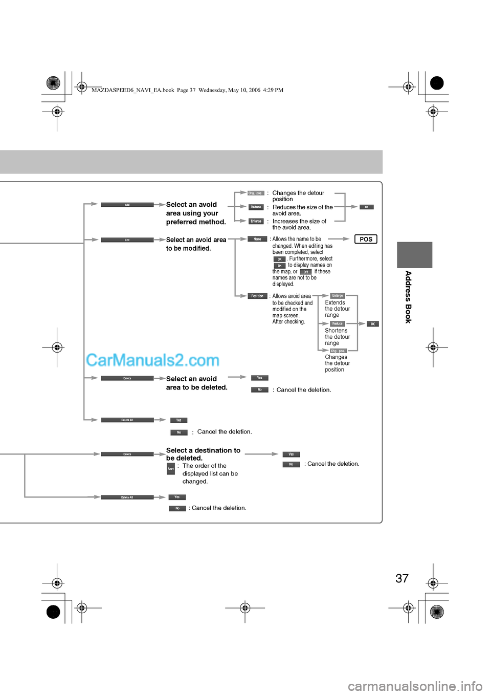
: Changes the detour
position
: Reduces the size of the
avoid area.
: Increases the size of
the avoid area.
Select an avoid
area using your
preferred method.
Select an avoid area
to be modified.
Select an avoid
area to be deleted.
:
:Allows the name to be
changed. When editing has
been completed, select
. Furthermore, select
to display names on
the map, or if these
names are not to be
displayed.
: Allows avoid area
to be checked and
modified on the
map screen.
After checking.
: Cancel the deletion.
Select a destination to
be deleted.
: The order of the
displayed list can be
changed.: Cancel the deletion.
: Cancel the deletion.
Cancel the deletion.
POS
Shortens
the detour
range
Changes
the detour
position Extends
the detour
range
MAZDASPEED6_NAVI_EA.book Page 37 Wednesday, May 10, 2006 4:29 PM
Page 397 of 413
40
Before
UseGetting
startedRoutingAddress
Book
Navigation Set Up
Navigation Set Up
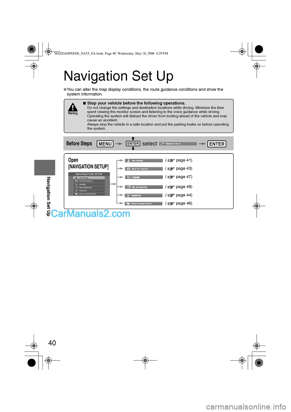
lYou can alter the map display conditions, the route guidance conditions and show the
system information.
nStop your vehicle before the following operations. Do not change the settings and destination locations while driving. Minimize the time
spent viewing the monitor screen and listening to the voice guidance while driving.
Operating the system will distract the driver from looking ahead of the vehicle and may
cause an accident.
Always stop the vehicle in a safe location and put the parking brake on before operating
the system.
Before Steps select
Warning
MENUENTERENTER
Open
[NAVIGATION SETUP] ( page 41)
( page 43)
( page 47)
( page 48)
( page 44)
( page 46)
MAZDASPEED6_NAVI_EA.book Page 40 Wednesday, May 10, 2006 4:29 PM
Page 398 of 413
![MAZDA MODEL MAZDASPEED 6 2007 (in English) Workshop Manual 41
Before
UseGetting
startedRoutingAddress
Book
Navigation Set Up
Navigation Set Up
Before Steps
select
select
User Setting
MENUENTERENTER
ENTERENTER
Open the
[USER SETTINGS]
screen
nMa MAZDA MODEL MAZDASPEED 6 2007 (in English) Workshop Manual 41
Before
UseGetting
startedRoutingAddress
Book
Navigation Set Up
Navigation Set Up
Before Steps
select
select
User Setting
MENUENTERENTER
ENTERENTER
Open the
[USER SETTINGS]
screen
nMa](/img/28/15594/w960_15594-397.png)
41
Before
UseGetting
startedRoutingAddress
Book
Navigation Set Up
Navigation Set Up
Before Steps
select
select
User Setting
MENUENTERENTER
ENTERENTER
Open the
[USER SETTINGS]
screen
nMap Color
Select a screen color from to options.
nMap Mode
lAuto : The display will automatically switch between Day
and Night illumination mode when the headlights are
turned off and on respectively.
lDay :The display will be presented in Day illumination mode
regardless of whether the headlights are on or off.
lNight : The display will be presented in Night illumination mode
regardless of whether the headlights are on or off.
nDistance
Select the distance unit from or .
nAverage Speed
Set the average speed for each road to be driven.
(This function sets the standard speed (average vehicle speed
for each route) used for calculating the estimated arrival time
when calculating the route time.)
: Average speed setting
:Changes back to default
nRoad Restriction Warnings
The display of warnings during route guidance when passing
through areas with traffic restrictions can be turned on or off.
MAZDASPEED6_NAVI_EA.book Page 41 Wednesday, May 10, 2006 4:29 PM
Page 399 of 413
![MAZDA MODEL MAZDASPEED 6 2007 (in English) Workshop Manual 42
Before
UseGetting
startedRoutingAddress
Book
Navigation Set Up
Navigation Set Up
Before Steps
select
select
User Setting
MENUENTERENTER
ENTERENTER
Open the
[USER SETTINGS]
screen
nA MAZDA MODEL MAZDASPEED 6 2007 (in English) Workshop Manual 42
Before
UseGetting
startedRoutingAddress
Book
Navigation Set Up
Navigation Set Up
Before Steps
select
select
User Setting
MENUENTERENTER
ENTERENTER
Open the
[USER SETTINGS]
screen
nA](/img/28/15594/w960_15594-398.png)
42
Before
UseGetting
startedRoutingAddress
Book
Navigation Set Up
Navigation Set Up
Before Steps
select
select
User Setting
MENUENTERENTER
ENTERENTER
Open the
[USER SETTINGS]
screen
nArrival Time
The time which is displayed until reaching the destination or a
way point can be set as an estimated arrival time or the
remaining time.
Select to display the estimated arrival time, or to
display the remaining time.
nKeyboard Layout
The layout of input keys can be selected as or .
nClock
Allows selection of whether clock is to be displayed.
nBeep
Allows selection of whether beep will sound.
MAZDASPEED6_NAVI_EA.book Page 42 Wednesday, May 10, 2006 4:29 PM
Page 400 of 413
43
Before
UseGetting
startedRoutingAddress
Book
Navigation Set Up
Navigation Set Up
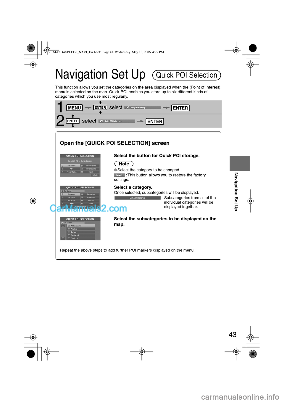
This function allows you set the categories on the area displayed when the (Point of Interest)
menu is selected on the map. Quick POI enables you store up to six different kinds of
categories which you use most regularly.
1 select
2 select
Quick POI Selection
MENUENTERENTER
ENTERENTER
Open the [QUICK POI SELECTION] screen
Select the button for Quick POI storage.
Note
lSelect the category to be changed
: This button allows you to restore the factory
settings.
Select a category.
Once selected, subcategories will be displayed.
: Subcategories from all of the
individual categories will be
displayed together.
Select the subcategories to be displayed on the
map.
Repeat the above steps to add further POI markers displayed on the menu.
MAZDASPEED6_NAVI_EA.book Page 43 Wednesday, May 10, 2006 4:29 PM
Page 401 of 413
44
Before
UseGetting
startedRoutingAddress
Book
Navigation Set Up
Navigation Set Up
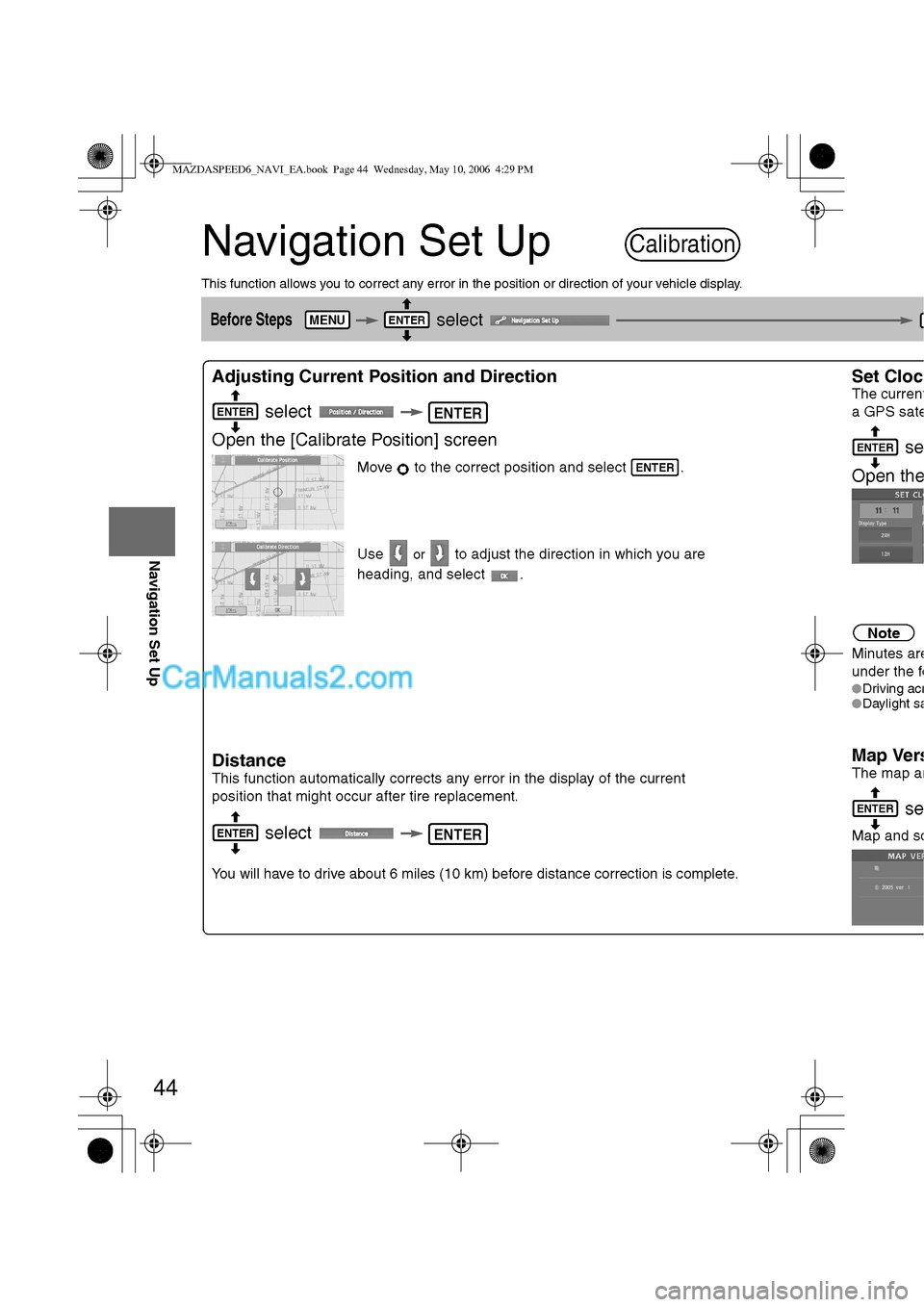
This function allows you to correct any error in the position or direction of your vehicle display.
Before Steps select
Adjusting Current Position and Direction
select
Open the [Calibrate Position] screen
Move to the correct position and select .
Use
or to adjust the direction in which you are
heading, and select .
Distance
This function automatically corrects any error in the display of the current
position that might occur after tire replacement.
select
You will have to drive about 6 miles (10 km) before distance correction is complete.
Set Cloc
The current
a GPS sate
se
Open th
e
Note
Minutes are
under the fo
lDriving acrlDaylight sa
Map Vers
The map an
se
Map and so
Calibration
MENUENTER
ENTERENTER
ENTER
ENTERENTER
ENTER
ENTER
MAZDASPEED6_NAVI_EA.book Page 44 Wednesday, May 10, 2006 4:29 PM
Page 402 of 413
45
Before
UseGetting
startedRoutingAddress
Book
Navigation Set Up
select
.
h you are
urrent
n is complete.
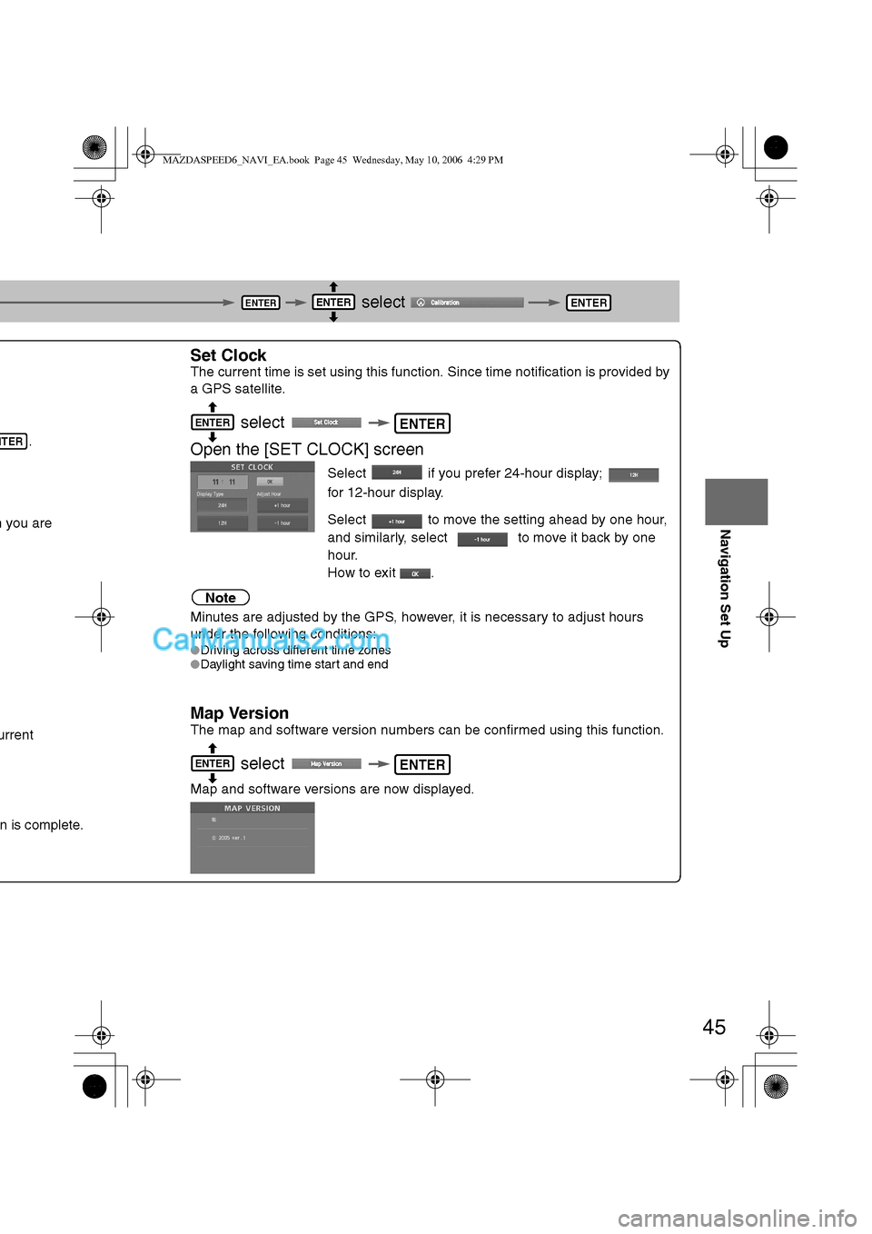
Set Clock
The current time is set using this function. Since time notification is provided by
a GPS satellite.
select
Open the [SET CLOCK] screen
Select if you prefer 24-hour display;
for 12-hour display.
Select to move the setting ahead by one hour,
and similarly, select to move it back by one
hour.
How to exit .
Note
Minutes are adjusted by the GPS, however, it is necessary to adjust hours
under the following conditions:
lDriving across different time zones
lDaylight saving time start and end
Map Version
The map and software version numbers can be confirmed using this function.
select
Map and software versions are now displayed.
ENTERENTERENTER
NTER
ENTERENTER
ENTERENTER
MAZDASPEED6_NAVI_EA.book Page 45 Wednesday, May 10, 2006 4:29 PM
Page 403 of 413
46
Before
UseGetting
startedRoutingAddress
Book
Navigation Set Up
Navigation Set Up
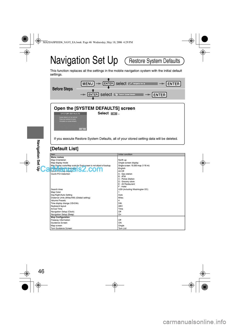
This function replaces all the settings in the mobile navigation system with the initial default
settings.
[Default List]
Before Steps
select
select
ItemInitial condition
Menu names
Map Orientation North up
Map display mode Single-screen display
Map Display scale/Map scale for Dual-screen is not object of backup.Single-screen: 10,000 map (1/16 mi)Display guidance language English
Quick-POI map display All Off
Quick-POI Selection A : Gas station
B : ATM
C : Police Station
D : Grocery store
E : All Restaurant
F : Hotel
Search Area US9 (including Washington DC)
Map Color 1
Day/Night/Auto Setting Auto
Distance Units (Miles/KM) (Global setting) Miles
Volume Presets 4
Time display change (12h/24h)24h
Keyboard layout ABC
Arrival Time Time
Navigation Setup (Clock) Off
Navigation Setup (Beep) On
Map Configuration
Freeway Infor m ati on O ff
Guidance Screen ON
Map screen Single
Turn Guidance Screen Turn List
Restore System Defaults
MENUENTERENTER
ENTERENTER
Open the [SYSTEM DEFAULTS] screen
Select .
If you execute Restore System Defaults, all of your stored setting data will be deleted.
MAZDASPEED6_NAVI_EA.book Page 46 Wednesday, May 10, 2006 4:29 PM
Page 405 of 413
![MAZDA MODEL MAZDASPEED 6 2007 (in English) Workshop Manual 48
Before
UseGetting
startedRoutingAddress
Book
Navigation Set Up
Navigation Set Up
Before Steps
select
select
Map Configuration
MENUENTERENTER
ENTERENTER
Open the
[MAP
CONFIGURATION]
s MAZDA MODEL MAZDASPEED 6 2007 (in English) Workshop Manual 48
Before
UseGetting
startedRoutingAddress
Book
Navigation Set Up
Navigation Set Up
Before Steps
select
select
Map Configuration
MENUENTERENTER
ENTERENTER
Open the
[MAP
CONFIGURATION]
s](/img/28/15594/w960_15594-404.png)
48
Before
UseGetting
startedRoutingAddress
Book
Navigation Set Up
Navigation Set Up
Before Steps
select
select
Map Configuration
MENUENTERENTER
ENTERENTER
Open the
[MAP
CONFIGURATION]
screen
nMap Screen
Select single or dual map display.
nTurn Guidance
Enlarged Junction Diagram
Before a fork in the road, an enlarged diagram of the junction automatically
appears in a second screen.This is to make route guidance even clearer.
Tu r n L i s t
While using route guidance, the
directions for the next junction where
you have to turn are shown as Turn
List.
Tu r n A r r o w
While using route guidance, the
directions for the next junction where
you have to turn are shown as Turn
Arrow.
nJunction Detail
Select whether the Enlarged Junction diagram screen is displayed automatically.
nFreeway Information
Allows selection of whether the guidance screen is to be displayed while driving on a freeway.
Single mapDual map
During route guidance, an enlarged
diagram of an approaching fork or junction
appears. When you drive past the junction,
the enlarged diagram disappears.During route guidance, an enlarged diagram of
the freeway automatically appears in a second
screen as you approach a fork on the freeway.
This is to make route guidance even clearer.
MAZDASPEED6_NAVI_EA.book Page 48 Wednesday, May 10, 2006 4:29 PM
Page 407 of 413
50
Before
UseGetting
startedRoutingAddress
Book
Vo i c e Recognition
If necessary
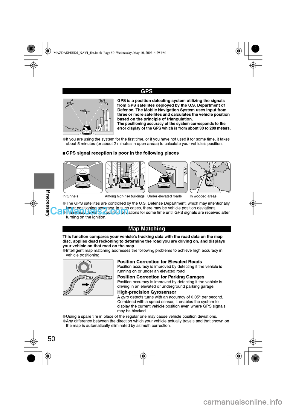
GPS is a position detecting system utilizing the signals
from GPS satellites deployed by the U.S. Department of
Defense. The Mobile Navigation System uses input from
three or more satellites and calculates the vehicle position
based on the principle of triangulation.
The positioning accuracy of the system corresponds to the
error display of the GPS which is from about 30 to 200 meters.
lIf you are using the system for the first time, or if you have not used it for some time, it takes
about 5 minutes (or about 2 minutes in open areas) to calculate your vehicle’s position.
nGPS signal reception is poor in the following places
lThe GPS satellites are controlled by the U.S. Defense Department, which may intentionally
lower positioning accuracy. In such cases, there may be vehicle position deviations.
lThere may be vehicle position deviations for some time until GPS signals are received after
turning on the ignition.
This function compares your vehicle’s tracking data with the road data on the map
disc, applies dead reckoning to determine the road you are driving on, and displays
your vehicle on that road on the map.
lIntelligent map matching addresses the following problems to achieve high accuracy in
vehicle positioning.
Position Correction for Elevated RoadsPosition accuracy is improved by detecting if the vehicle is
running on or under an elevated road.
Position Correction for Parking GaragesPosition accuracy is improved by detecting if the vehicle is
driving in an elevated or underground parking garage.
High-precision GyrosensorA gyro detects turns with an accuracy of 0.05° per second.
Combined with a speed sensor, it enables the system to
display the current vehicle position even where GPS signals
may be blocked.
lUsing a spare tire in place of the regular one may cause vehicle position deviations.
lAny difference between the direction which your vehicle actually travels and that shown on
the map is automatically eliminated by azimuth correction.
GPS
In tunnelsAmong high-rise buildingsUnder elevated roads In wooded areas
Map Matching
MAZDASPEED6_NAVI_EA.book Page 50 Wednesday, May 10, 2006 4:29 PM