navigation system MERCEDES-BENZ CL-Class 2002 C215 Comand Manual
[x] Cancel search | Manufacturer: MERCEDES-BENZ, Model Year: 2002, Model line: CL-Class, Model: MERCEDES-BENZ CL-Class 2002 C215Pages: 251
Page 173 of 251
171 Destination input
Introduction
Audio
Telephone
Navigation
Index Info Services and
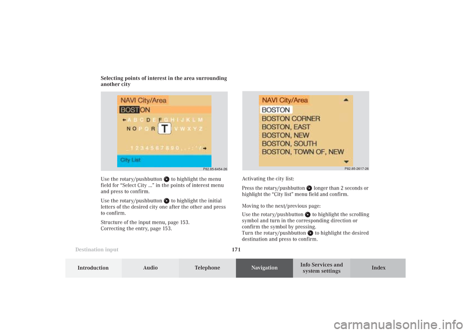
system settings Selecting points of interest in the area surrounding
another city
Use the rotary/pushbutton
to highlight the menu
field for “Select City ...” in the points of interest menu
and press to confirm.
Use the rotary/pushbutton to highlight the initial
letters of the desired city one after the other and press
to confirm.
Structure of the input menu, page 153.
Correcting the entry, page 153.
P82.85-2617-26
Activating the city list:
Press the rotary/pushbutton
longer than 2 seconds or
highlight the “City list” menu field and confirm.
Moving to the next/previous page:
Use the rotary/pushbutton to highlight the scrolling
symbol and turn in the corresponding direction or
confirm the symbol by pressing.
Turn the rotary/pushbutton to highlight the desired
destination and press to confirm.
P82.85-6454-26
09-NAVI1-25-US.pm509.07.2004, 14:27 Uhr 171
Page 174 of 251
172
Destination input
Audio TelephoneNavigation
Index Info Services and
system settings Introduction
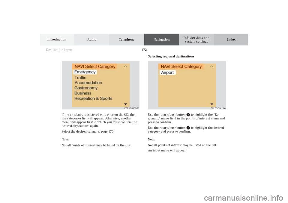
Selecting regional destinations
Use the rotary/pushbutton
to highlight the “Re-
gional...” menu field in the points of interest menu and
press to confirm.
Use the rotary/pushbutton to highlight the desired
category and press to confirm.
Note:
Not all points of interest may be listed on the CD.
An input menu will appear. If the city/suburb is stored only once on the CD, then
the categories list will appear. Otherwise, another
menu will appear first in which you must confirm the
desired city/suburb again.
Select the desired category, page 170.
Note:
Not all points of interest may be listed on the CD.
P82.85-6100-26
P82.85-6101-26
09-NAVI1-25-US.pm509.07.2004, 14:28 Uhr 172
Page 175 of 251
173 Destination input
Introduction
Audio
Telephone
Navigation
Index Info Services and
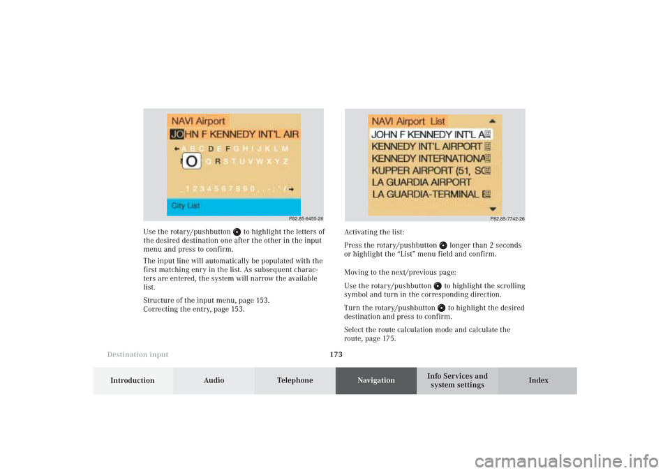
system settings Use the rotary/pushbutton
to highlight the letters of
the desired destination one after the other in the input
menu and press to confirm.
The input line will automatically be populated with the
first matching enry in the list. As subsequent charac-
ters are entered, the system will narrow the available
list.
Structure of the input menu, page 153.
Correcting the entry, page 153.Activating the list:
Press the rotary/pushbutton
longer than 2 seconds
or highlight the “List” menu field and confirm.
Moving to the next/previous page:
Use the rotary/pushbutton to highlight the scrolling
symbol and turn in the corresponding direction.
Turn the rotary/pushbutton to highlight the desired
destination and press to confirm.
Select the route calculation mode and calculate the
route, page 175.
P82.85-6455-26
P82.85-7742-26
09-NAVI1-25-US.pm509.07.2004, 14:28 Uhr 173
Page 176 of 251
174
Destination input
Audio TelephoneNavigation
Index Info Services and
system settings Introduction
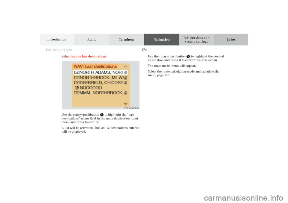
Selecting the last destinations
Use the rotary/pushbutton
to highlight the “Last
destinations” menu field in the main destination input
menu and press to confirm.
A list will be activated. The last 12 destinations entered
will be displayed.Use the rotary/pushbutton
to highlight the desired
destination and press it to confirm your selection.
The route mode menu will appear.
Select the route calculation mode and calculate the
route, page 175.
P82.85-6102-26
09-NAVI1-25-US.pm509.07.2004, 14:28 Uhr 174
Page 177 of 251
175 Destination input
Introduction
Audio
Telephone
Navigation
Index Info Services and
system settings
Calculate the routeSelecting the route calculation mode and
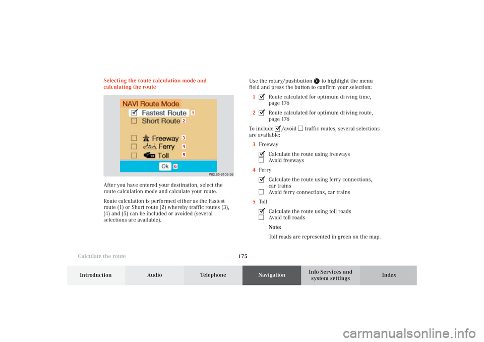
calculating the route
After you have entered your destination, select the
route calculation mode and calculate your route.
Route calculation is performed either as the Fastest
route (1) or Short route (2) whereby traffic routes (3),
(4) and (5) can be included or avoided (several
selections are available).Use the rotary/pushbutton
to highlight the menu
field and press the button to confirm your selection:
1
Route calculated for optimum driving time,
page 176
2Route calculated for optimum driving route,
page 176
To include
/avoid
traffic routes, several selections
are available:
3Freeway
Calculate the route using freewaysAvoid freeways
4FerryCalculate the route using ferry connections,
car trainsAvoid ferry connections, car trains
5TollCalculate the route using toll roadsAvoid toll roads
Note:
Toll roads are represented in green on the map.
P82.85-6103-26
1
6
3452
09-NAVI1-25-US.pm509.07.2004, 14:28 Uhr 175
Page 178 of 251
176
Destination input
Audio TelephoneNavigation
Index Info Services and
system settings Introduction
Calculate the route
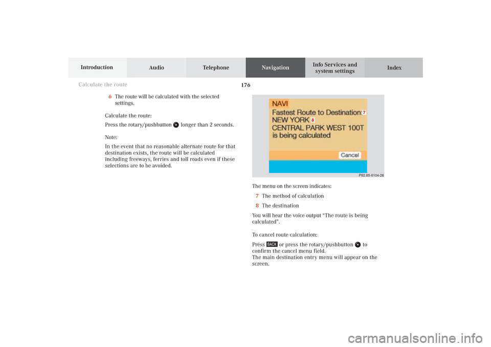
The menu on the screen indicates:
7The method of calculation
8The destination
You will hear the voice output “The route is being
calculated”.
To cancel route calculation:
Press
or press the rotary/pushbutton
to
confirm the cancel menu field.
The main destination entry menu will appear on the
screen.P82.85-6104-26
8
7
6The route will be calculated with the selected
settings.
Calculate the route:
Press the rotary/pushbutton
longer than 2 seconds.
Note:
In the event that no reasonable alternate route for that
destination exists, the route will be calculated
including freeways, ferries and toll roads even if these
selections are to be avoided.
09-NAVI1-25-US.pm509.07.2004, 14:28 Uhr 176
Page 179 of 251
177 Destination input
Introduction
Audio
Telephone
Navigation
Index Info Services and
system settings
Calculate the route
P82.85-2604-26
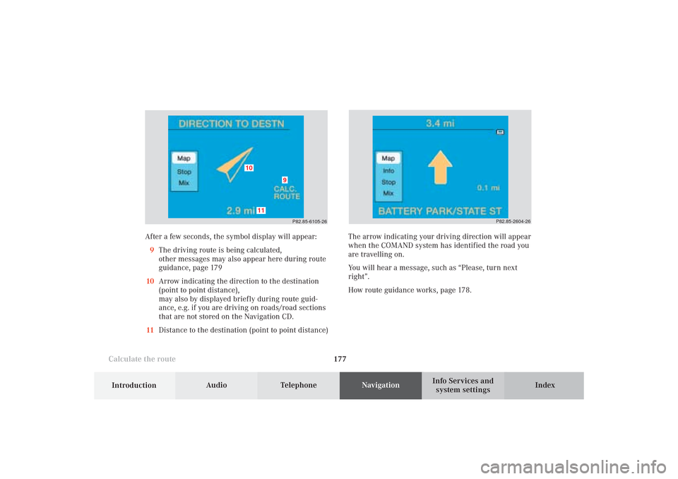
After a few seconds, the symbol display will appear:
9The driving route is being calculated,
other messages may also appear here during route
guidance, page 179
10Arrow indicating the direction to the destination
(point to point distance),
may also by displayed briefly during route guid-
ance, e.g. if you are driving on roads/road sections
that are not stored on the Navigation CD.
11Distance to the destination (point to point distance)
P82.85-6105-26
10
11
9
The arrow indicating your driving direction will appear
when the COMAND system has identified the road you
are travelling on.
You will hear a message, such as “Please, turn next
right”.
How route guidance works, page 178.
09-NAVI1-25-US.pm509.07.2004, 14:28 Uhr 177
Page 180 of 251
Audio TelephoneNavigation
Index Info Services and
system settings Introduction
Route guidance
178
P82.85-4812-29
1
875
4
3
2
1
6
12
1110679
13
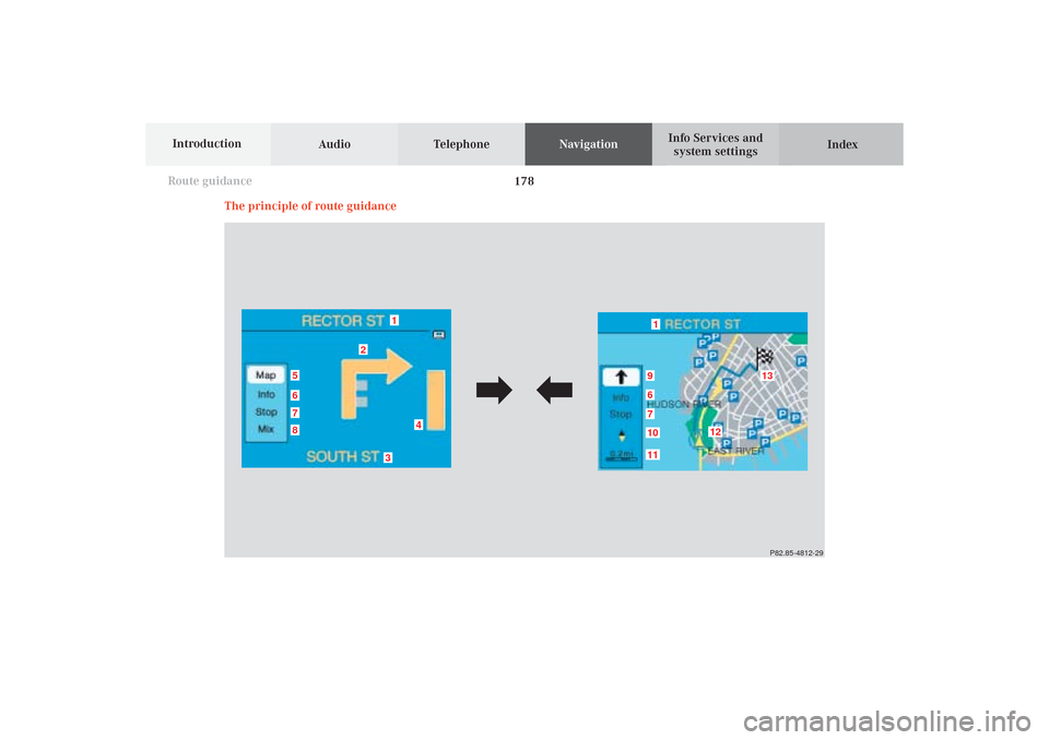
The principle of route guidance
10-NAVI2-25-US.pm517.10.2001, 10:42 Uhr 178
Page 181 of 251
179
Route guidance
Introduction
Audio Telephone
Navigation
Index Info Services and
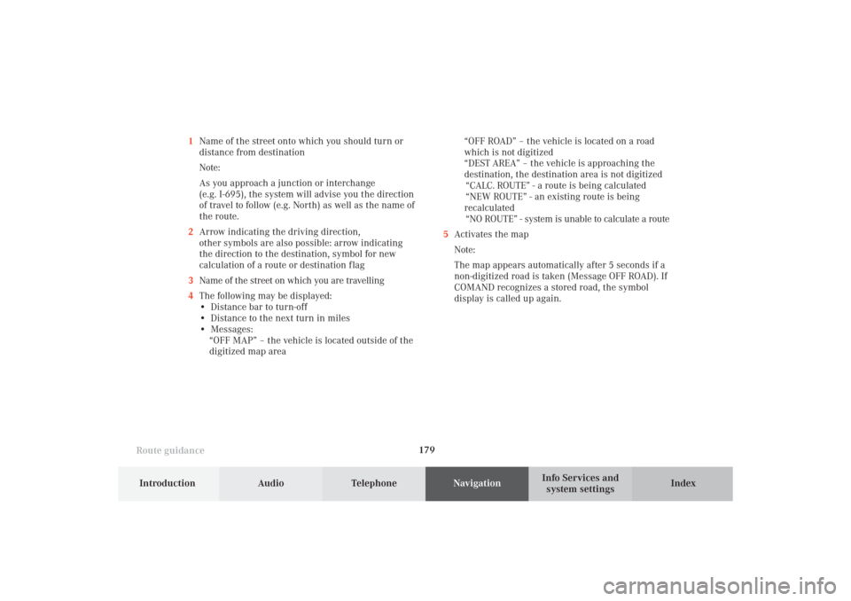
system settings 1Name of the street onto which you should turn or
distance from destination
Note:
As you approach a junction or interchange
(e.g. I-695), the system will advise you the direction
of travel to follow (e.g. North) as well as the name of
the route.
2Arrow indicating the driving direction,
other symbols are also possible: arrow indicating
the direction to the destination, symbol for new
calculation of a route or destination f lag
3Name of the street on which you are travelling
4The following may be displayed:
• Distance bar to turn-off
• Distance to the next turn in miles
• Messages:
“OFF MAP” – the vehicle is located outside of the
digitized map area“OFF ROAD” – the vehicle is located on a road
which is not digitized
“DEST AREA” – the vehicle is approaching the
destination, the destination area is not digitized
“CALC. ROUTE” - a route is being calculated
“NEW ROUTE” - an existing route is being
recalculated
“NO ROUTE” - system is unable to calculate a route
5Activates the map
Note:
The map appears automatically after 5 seconds if a
non-digitized road is taken (Message OFF ROAD). If
COMAND recognizes a stored road, the symbol
display is called up again.
10-NAVI2-25-US.pm517.10.2001, 10:42 Uhr 179
Page 182 of 251
Audio TelephoneNavigation
Index Info Services and
system settings Introduction
Route guidance
180
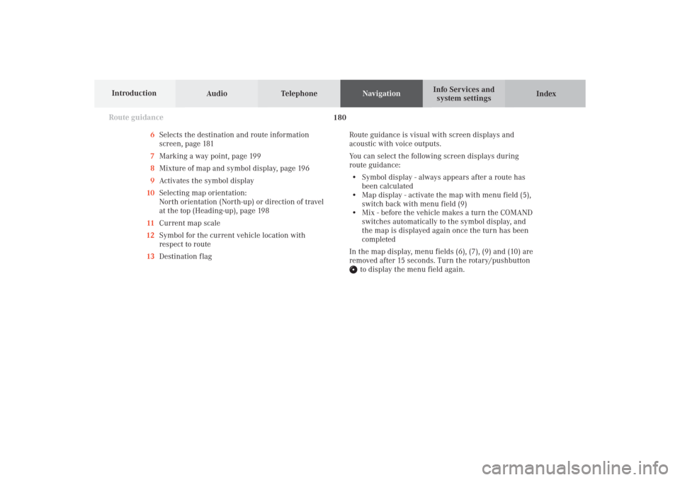
6Selects the destination and route information
screen, page 181
7Marking a way point, page 199
8Mixture of map and symbol display, page 196
9Activates the symbol display
10Selecting map orientation:
North orientation (North-up) or direction of travel
at the top (Heading-up), page 198
11Current map scale
12Symbol for the current vehicle location with
respect to route
13Destination flagRoute guidance is visual with screen displays and
acoustic with voice outputs.
You can select the following screen displays during
route guidance:
• Symbol display - always appears after a route has
been calculated
• Map display - activate the map with menu field (5),
switch back with menu field (9)
• Mix - before the vehicle makes a turn the COMAND
switches automatically to the symbol display, and
the map is displayed again once the turn has been
completed
In the map display, menu fields (6), (7), (9) and (10) are
removed after 15 seconds. Turn the rotary/pushbutton
to display the menu field again.
10-NAVI2-25-US.pm517.10.2001, 10:42 Uhr 180