navigation system MERCEDES-BENZ E-Class WAGON 2011 S212 Comand Manual
[x] Cancel search | Manufacturer: MERCEDES-BENZ, Model Year: 2011, Model line: E-Class WAGON, Model: MERCEDES-BENZ E-Class WAGON 2011 S212Pages: 234, PDF Size: 8.64 MB
Page 84 of 234

Reduc
ingv olume durin ganavigation
anno uncemen t The
volu meofan active audio orvide osource
can beautomatica llyredu cedduring a
navig ationannou ncement.
X Sele ctNavi in
the mainfunction barby
sli ding ZVandturning cVdtheCOM AND
controll erand pres sW toconfirm.
X Sele ctAudio Fadeout and
pres sW to
confirm.
Depend ingonthe previ ousstatus ,the
function isswi tched onO oroff ª.
Settin gthe volume manuall y X
Adjust thevolu meusing the qcontrol
knob during anavig ationannou ncement.
or
X Sele ctRPT on
the map displa yw hent he
menu isshown, andsetthe volume withthe
q cont rolknob. Avoiding
asection ofther oute
blocked byatraffic jam
This function bloc ksasectio no fthe route
ahead ofyou. Youcansetthe length ofthe
blocked routesection. Ifpossible, COMAND
calculates adetour around theblocked
section ofthe route.
X To switch onnavigation mode:pressthe
Ø functionbutton.
X To show themenu: pressWthe COMAND
cont roller.
X Select Route in
the navigation system
menu barbyturning cVdtheCOMAND
cont roller andpress Wtoconfirm .
X Select Detour and
press Wtoconfirm .
X To block asection ofthe route: select
Longer or
Shorter repeatedly
andconfirm
using Wuntil thedesired sectionhasbeen
selected. i
The total length ofthe section thatcanbe
blocked isdefined bythe digital map.The
menu itemsareavaila bleaccordingly.
X To star troute calculation: selectStart and
press Wtoconfirm .
X To delete theblocke dsection: select
Del ete while
them essage isshown and
pres sW tocon firm.
COMA NDcalc ulates ther out ew itho utthe
block . Selecting
analterna tiveroute
Intr odu ction With
the"Alternativ erout e"func tion,rout es
oth erthan theorigin alone canbecalc ulated.
Opt ion 1 X
To switch onnavigat ionmod e:press the
Ø function button.
X To show them enu :press Wthe COMA ND
con troller.
X Selec tRout e in
the navig ation system
men ubarby turnin gcVd theCOMA ND
con troller andpress Wtocon firm .
X Selec tAlte rnativeRoute and
press W
to con firm .
On the right -handside, youwillsee
inf orm ation onthe curr entlyselec ted
alter native rout e,e.g. distance,est imat ed
remain ingdrivin gtimea nd estimat edtim e
of arriv al.Route sections used (e.g.
fre eways, tunnels )are displayed as
symbols . 82
Rou
teguid anceNavigat
ion
Page 85 of 234
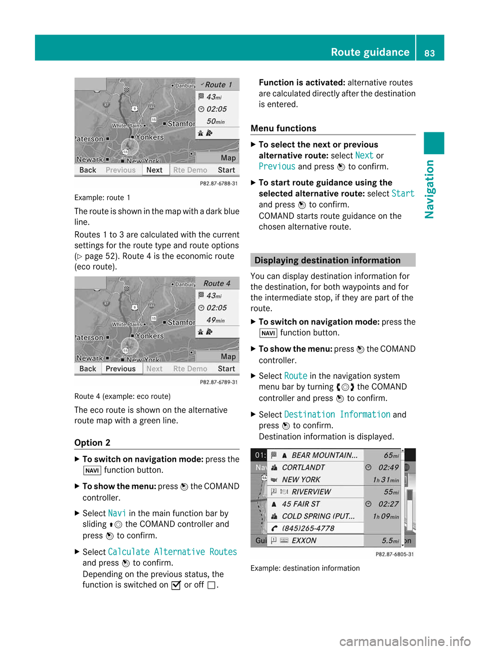
Exam
ple: rou te1
The routeissho wninthe mapw ithad arkb lue
li ne.
Ro ute s1t o3a recalcu lated withthecurrent
settings forthe route typeandroute options
(Y pag e52). Rou te4isthe economic route
(eco route) . Rou
te4( example: ecoroute)
The eco route isshown onthe alternat ive
route mapwithagreen line.
Opt ion 2 X
To switch onnavigat ionmode: pressthe
Ø function button .
X To show themenu: pressWthe COMAND
con troller.
X Select Navi in
the main function barby
sliding ZVtheCOMAND controller and
press Wtocon firm.
X Select Calculat eAlternat iveRoutes and
press Wtocon firm.
Depen dingonthe previous status,the
func tion isswitched onO oroff ª. Function
isactivat ed:alternat iveroutes
are calculated directlyafter thedestin ation
is ent ered.
Menu functions X
To select thenext orprevious
alter native route:select Next or
Previous and
press Wtocon firm.
X To star trout eguidance usingthe
selected alternative route:select Start and
press Wtocon firm.
COMAND startsroute guidance onthe
chosen alternativeroute. Displaying
destinationinform ation
You candisplay destinationinformation for
the destin ation, forboth waypoints andfor
the inter mediate stop,ifthey arepart ofthe
route.
X To switch onnavigat ionmode: pressthe
Ø function button .
X To show themenu: pressWthe COMAND
con troller.
X Select Route in
the navigation system
menu barbyturn ingcVd theCOMAND
con troller andpress Wtocon firm.
X Select Destinat ionInformat ion and
press Wtocon firm.
Dest ination information isdisplayed. Ex
ample: destinationinform ation Rout
eguidance
83Navigation Z
Page 86 of 234
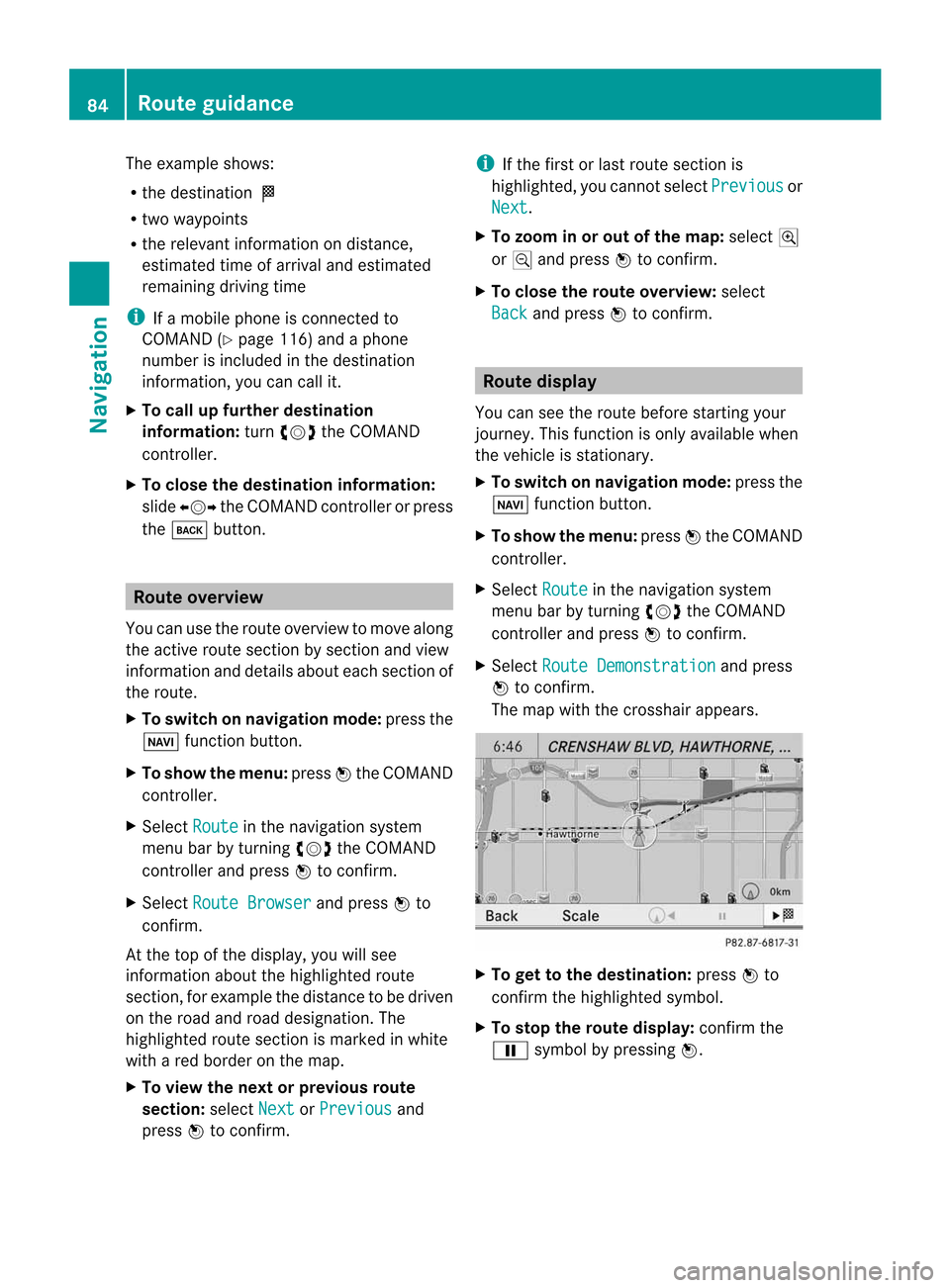
The
example shows:
R the destinat ionO
R two waypoi nts
R the relevant informationondistanc e,
estimated timeofarrival andestimated
remaining drivingtime
i Ifam obile phone isconn ected to
COMAND (Ypage 116)andaphone
number isincluded inthe destinat ion
inform ation,youcan callit.
X To call upfurther destinat ion
informa tion:turncVd theCOMAND
cont roller.
X To close thedestinat ioninforma tion:
slide XVY theCOMAND controller orpress
the k button . Route
overview
You canusetheroute overview tomove along
the active routesectionbysect ionand view
inform ationanddetails abouteachsectionof
the route.
X To switch onnavigation mode:pressthe
Ø functionbutton .
X To show themenu: pressWthe COMAND
cont roller.
X Select Route in
the navigation system
menu barbyturnin gcVd theCOMAND
cont roller andpress Wtoconf irm.
X Select Route Browser and
press Wto
conf irm.
At the top ofthe display ,you will see
inform ationabout thehighlighted route
sect ion,forexample thedistanc etob edriven
on the road androad designation. The
highlighted routesectionismarked inwhite
with ared border onthe map.
X To view thenext orprevious route
section: selectNext or
Previous and
press Wtoconf irm. i
Ifthe first orlast route sectionis
highlighted, youcann otselect Previous or
Next .
X To zoom inor out ofthe map :select N
or M and press Wtoconf irm.
X To close therout eoverview: select
Back and
press Wtoconf irm. Route
display
You canseetheroute before startingyour
journey. Thisfunct ionisonly availab lewhen
the vehicle isstation ary.
X To switch onnavigation mode:pressthe
Ø functionbutton .
X To show themenu: pressWthe COMAND
cont roller.
X Select Route in
the navigation system
menu barbyturnin gcVd theCOMAND
cont roller andpress Wtoconf irm.
X Select Route Demonstrat ion and
press
W toconf irm.
The map withthecrosshair appears. X
To get tothe destinat ion:press Wto
conf irmthehighlighted symbol.
X To stop therout edisplay: confirmthe
Ë symbol bypressing W. 84
Rout
eguidanceNavigation
Page 87 of 234
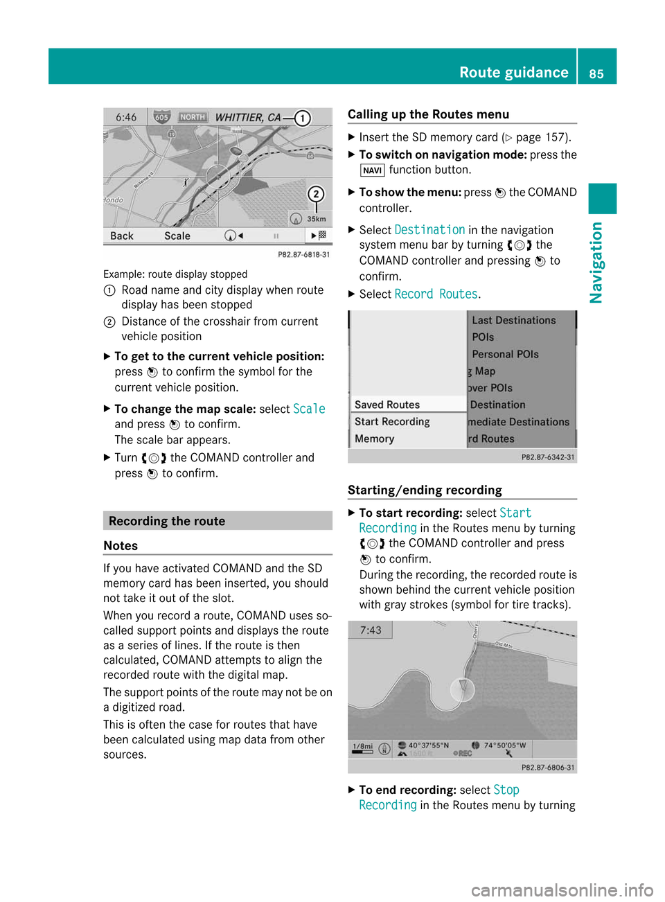
Exam
ple: rou tedispl aystop ped
: Road nam eand city displ aywhen rou te
di spl ayhasb eens top ped
; Distance ofthe cros shairfrom current
veh iclep ositio n
X To gettot he cur rent vehicle position:
pres sW tocon firmt hesymbo lfor the
cur ren tvehicle position .
X To change themap scale: selectScale and
press Wtocon firm.
The scale barappears.
X Turn cVd theCOMAND controller and
press Wtocon firm. Recording
therout e
Notes If
you have activated COMAND andtheSD
memory cardhasbeen insert ed,you should
not take itout ofthe slot.
When yourecor daroute, COMAND usesso-
called support pointsand displays theroute
as as eries oflines. Ifthe route isthen
calculated, COMANDattemptstoalign the
recor dedroute withthedigital map.
The support pointsofthe route maynotbeon
ad igitized road.
This isoften thecase forroutes thathave
been calculated usingmapdata from other
sources. Calling
upthe Rout esmenu X
Inser tthe SD memory card(Ypage 157).
X To switch onnavigat ionmode: pressthe
Ø function button .
X To show themenu: pressWthe COMAND
con troller .
X Select Destina tion in
the navigation
system menubarbyturn ingcVd the
COMAND controller andpressing Wto
con firm.
X Select Record Routes .
Sta
rting/ending recording X
To star trecord ing:select Start Recordi
ng in
the Routes menubyturn ing
cVd theCOMAND controller andpress
W tocon firm.
Durin gthe recor ding, therecor dedroute is
shown behind thecurren tvehicle position
with gray strokes (symbol fortire tracks). X
To end record ing:select Stop Recordi
ng in
the Routes menubyturn ing Rout
eguida nce
85Navigation Z
Page 89 of 234

X
Sel ect Swap in
the menu byturni ngcVd
the COMAND controllera nd pre ssW to
confi rm.
De letin gthe route
X Sel ect Delete in
the menu byturning
cVd theCOMAND controller and press
W toconfi rm.
Ap rompt appears asking whethe rthe route
should bedeleted.
X Select Yes or
No and
press Wtoconfirm .
If you select Yes ,t
he route willbedeleted.
If you select No ,t
he process willbe
canceled.
Scanning thememory The
SDmemory cardisinserted.
X Select Memory in
the Routes menu
(Y page 85)byturning cVdtheCOMAND
cont roller andpress Wtoconfirm .
The route memory isdispla yed. Off-r
oadand off-ma p
Import antsafety note G
WARNING
The COMAND navigation systemmaydirect
you tooff-road routesthatyour vehicle may
not becapable oftraversing throughwithout
damaging yourtires, wheels orvehicle. Itis
the driver's soleresponsibility todetermine
the suitabili tyof the route. Off-roadroutes
may beofvarying conditions andtheir appropriateness
foruse may beaffected by
various factorssuchastime ofday, time of
year andimmediate weatherconditions that
cannot bejudged ortaken intoconsideration
by the COMAND system.
Route guidance toad estination thatis
not onadigitized road COMAND
canguide youtodestinations
which arewithin thearea covered bythe
digital map,butwhich arenot themselves
recorded onthe map.
These destinations areknown asoff-r oad
destinations, whichyoucan enter using the
map, forexample. Inthese cases, COMAND
guides youforaslong aspossible with
navigation announcemen tsand displa yson
roads known tothe system. Example:
routeguidance toan off-road destination
: Off-r oaddestination
; Off-r oadroute section (dashed blue)
= Current vehicleposition (thetipofthe
triangle indicates thevehicle’s direction
of travel)
? Off-r oad(ifavaila ble)
If the vehicle reaches anarea which isnot part
of the digital map,thedispla yappea rsas a
split-screen view.Onthe right-hand side,an
arrow appearswhich points tooff-r oad
destination :.Youwill hear the
announc ement:"Please followthearrow on
the display" .Asthe vehicle approachesthe
destination, theArea ofdestination reached message
appears. Route
guidance
87Navigation Z
Page 90 of 234
Route
guidanc efrom anoff-road
lo cati ontoad esti nation If
th ev ehicle posit ioniswith inthea rea
cov ered bythed igit almap, butthem apdoes
no tc ontain anyinform ationabout that
locat ion,the veh icle isin an off-road locat ion.
COMA NDisalso able toguide youtoa
dest inationeven from anoff-road locat ion.
At thes tart of ther out eguidan ce,you willsee
th eOff Mapped Road mes
sage, anarro w
and thed istanc etot he destina tion .The arrow
shows thecompass headingtothe actual
destin ation.
The route ishighlighted blue,startingfrom
the last recogn izedstreet the vehicle wason
before itleft themap.
As soon asthe vehicle isback onaroad
kn own tothe system, routeguidance
con tinues inthe usual way.
Rout eguida ncefrom anoff-m ap
location toad esti nation If
th ev ehicle posit ionisouts idethea rea
cov ered bythed igitalmap, then thev ehicle
is in an off-map locat ion.COMAND isalso
able toguide youtoad estination evenfrom
an off-map location.
At the start ofthe route guidance,youwillsee
the Off Mapped Road message,
anarrow
and thedistance tothe destination. The
direction arrowshows thecompass heading
to the destination.
The route ishighlig htedbluefrom thenearest
road known tothe system.
As soon asthe vehicle isback onaroad
known tothe system, routeguidance
cont inues inthe usua lway.
Off-road duringrouteguidance Due
toroadworks, forexample, theremaybe
differences betweenthedata onthe digital
map andtheactual course ofthe road.
In such cases, thesystem willtemporarily be
unable tolocate thevehicle position onthe digital
mapandthus considers thevehicle to
be inan off-road position.
In the displa y,you willsee theOff Mapped Road message,
anarrow andthedistance to
the destination. Thedirection arrowshows
the compass headingtothe destination.
As soon asthe system canassign thevehicle
position tothe map again,route guidance
cont inues inthe usua lway. Tra
ffic reports Condition
s
To receive real-time trafficreports via
satellite radio,yourequire:
R optionally available satellite radio
equi pment
R as ubscription toSIRIUS XMSatellite Radio
Traffic Message Service
Further information onsatellite radiois
avail able inthe "Satellite radio"section
(Y page 148).
COMAND canreceive trafficreports via
satellite radioandtake account ofthese for
route guidanceinthe navigation system.
Received trafficreports aredispla yedinthe
map either astext oras icons. Real-time
traffic report sint he map
COMAND canshow certain trafficincidents
on the map. Traffic reports areshown onthe
map atscales of0.05 mito20 mi.
X To hide themenu: slideZVtheCOMAND
cont roller and,when theFull Screen menu
itemisshown, pressWtoconfirm.
The map canbeseen inthe full-screen
displa y.
X Turn cVd theCOMAND controller untilthe
desired mapscale isset. 88
Tr
affic report sNavigation
Page 96 of 234

X
To acc ept the suggeste droute :pre ss
W the COMAND controller.
X To conti nue along the original route :
sel ect Reject by
turning cVd the
CO MAND controller and pressW to
confi rm. De
stinati onmemo ry Home
addres s(My addres s)
En teri ngthe home addres sviaaddres s
en try X
Initi ally pro cee dasdescri bedint he
"Adopting anaddress bookentryasah ome
address" andconfirm MyAddress by
pressing W.
X To enter thehome addressforthe first
time: confirm NewEntry by
pressing W.
X To change thehome address: select
Change in
the menu showing thehome
address byturning cVdtheCOMAND
cont roller andpress Wtoconfirm .
X Confirm NewEntry by
pressing W.
X In both cases, enterthehome address asa
destination, e.g.asac ity, street andhouse
number (Ypage 54).Then, savethehome
address (Ypage 57).
Adopting anadd ress book entry asa
home address X
To switch onnavigation mode:pressthe
Ø functionbutton. X
To show themenu: pressWthe COMAND
cont roller.
X Select Dest. in
the navigation system
menu barbyturning cVdtheCOMAND
cont roller andpressing Wtoconfirm .
X Select FromMemory and
press Wto
confirm .
You willsee thedestination memorylist
either withthecharacter bar(option 1)or
as as election list(option 2).
Option 1:destination memorylistwith
character bar X
Slide ZVtheCOMAND controller
repeatedly untilthedestination memory
list appea rsas as election list.
Option 2:destination memorylistas
selec tionlist The
MyAddress entr
yisl isted asthe first
entr yint he destination memory.
X Select MyAddress by
turning cVdthe
COMAND controller andpress Wto
confirm . 94
Des
tination memoryNavigation
Page 100 of 234

Storing
thevehicle position inthe list
of previous destinations
X To switch onnavigation mode:pressthe
Ø functionbutton.
X To show themenu: pressWthe COMAND
cont roller.
X Select Position in
the navigation system
menu barbyturnin gcVd theCOMAND
cont roller andpress Wtoconf irm.
X Select Save vehicle position and
press
W toconf irm.
COMAND storesthecurrent vehicle
position asad estination inthe listof
previous destinations . Storing
thecrosshair positioninthe
list ofprevious destinations
Ac rossha irapp ears onthe map ifyou have
moved themap manua lly.Y ou can store the
crosshair positionasad estinat ioninthe list
of previous destinations.
X To show themenu: pressWthe COMAND
cont roller.
X Select Position in
the navigation system
menu barbyturnin gcVd theCOMAND
cont roller andpress Wtoconf irm.
X Select Savecrosshair position and
press Wtoconf irm. Dele
ting oneofthe previous
destinat ions
X To switch onnavigation mode:pressthe
Ø functionbutton .
X To show themenu: pressWthe COMAND
cont roller.
X Select Destination in
the navigation
system menubarbyturnin gcVd the
COMAND controller andpressing Wto
conf irm. X
Select Fromlast destinations and
press Wtoconf irm.
The listoflast destination sappears.
X Select thedesired destinationandpress
W tocon firm.
The destin ationaddress appears.
X Select Delete and
press Wtocon firm.
Ap rompt appears asking whethe rthe entr y
should bedeleted.
X Select Yes or
No and
press Wtoconfirm .
If you select Yes ,t
he entr yisd eleted.
If you select No ,t
he process willbeaborted. Map
operation andsettings Note
Company logosdisplayedonthe map are
trademarks ofthe respective companies and
used solely forthe purpose ofindicating the
location ofthese companies. Theuseofsuch
logos onthe map does notindicate approval
of, support ofor advertising bythese
companies forthe navigation systemitself. Setting
themap scale
X To hide themenu: slideZVtheCOMAND
cont roller and,when theFull Screen menu
itemisshown, pressW.
X To call upthe scale bar:assoon asyou
turn cVd theCOMAND controller, scale
bar =appea rs.
X Turn cVd untilthedesired scaleisset. 98
Map
operat ionand settingsNavigation
Page 101 of 234

:
Set map scaleas an umb erwith uni t
; Currentl ysetmap scaleas ind icated by
the need leon the scaleba r
= Mapscale
Unit ofmea sureme nt: inthe COMAND
di spl aydepe nds onthe selecti onmad efor the
instr umentclu ster (seethe veh icle
Ope rator'sManua l). Mov
ingt he map
Sho wing the crossh air X
To hide themen u:slide ZV theCOMAND
control lera nd, when the FullScreen menu
itemi sshown, pressW.
X To scroll themap: slideXVY, ZVÆor
aVb theCOMAND controller.
Ac rossha irapp ears onthe map. Ifyou slide
it aga in,the map moves inthe
correspo ndingdirection under the
crossha ir. Map
withcrossha ir
: Current vehicl eposition
; Cross hair
= Detail softhe crossha irposi tion
? Map scale selected Displ
ay= may bethe name ofas treet, for
exampl e,provid edthe digitalmap contains
the necessary data.Alter natively, itmay show
the geo- coor dinat eposit ion ofthe crosshair
if the Geo- coordinates display
isswitc hed
on (Ypage 102).
Hid ing thec rossh airand center ingthe
ma ponthe vehicle position or
destina tion X
Press the% backbutton twice.
The cross hairdisappears andthemap is
set tothe vehicle position .
or
X Set themap tothe vehicle position ;see the
explanat ionbelow. Centering
themap onthe vehicle or
destina tionposition
Centering themap onthe vehicle
position X
To show themenu: pressWthe COMAND
con troller.
X Select Positio n in
the navigation system
menu barbysliding VÆandturningcVd
the COMAND controller andpress Wto
con firm.
X Select Vehicle PositionMap and
press
W tocon firm or,ifthe cross hairisshown,
press the% backbutton .
This hides thecross hair.
Centering onthe destina tion This
function requires thataroute toa
destin ationhasbeen calculated. Ifthe route
includes waypoints andanintermediate stop,
the map canalso beset tothese position s.
X To show themenu: pressWthe COMAND
con troller.
X Select Positio n in
the navigation system
menu barbysliding VÆandturningcVd Map
opera tionandsettings
99Navigation Z
Page 104 of 234
Map
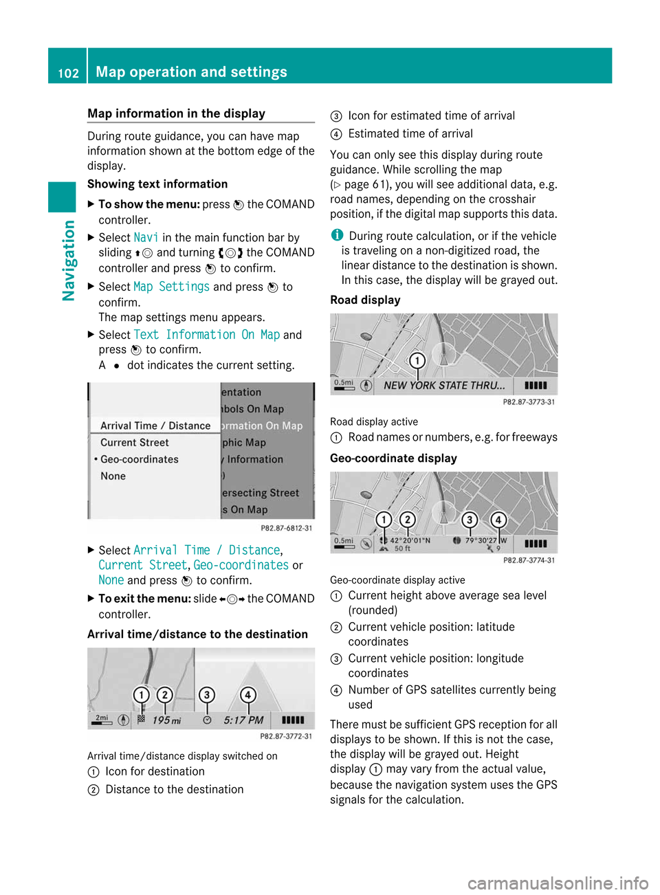
information inthe display During
routeguidance, youcan have map
informati onshow natthe bottom edgeofthe
displa y.
Showing textinformat ion
X To show themenu: pressWthe COMAND
cont roller.
X Select Navi in
the main functionbar by
sliding ZVandturning cVdtheCOMAND
cont roller andpress Wtoconfirm .
X Select MapSettings and
press Wto
confirm .
The map settin gsmenu appears.
X Select TextInformation OnMap and
press Wtoconfirm .
A # dot indicates thecurrent setting. X
Select Arrival Time/Distance ,
Current Street ,
Geo-coordinates or
None and
press Wtoconfirm .
X To exit themenu: slideXVY theCOMAND
cont roller.
Arrival time/distance tothe destination Arrival
time/distanc edisplay switched on
: Icon fordestination
; Distanc etot he destination =
Icon forestimated timeofarrival
? Estimated timeofarrival
You canonly seethis displa yduring route
guida nce.While scrolling themap
(Y page 61),youwillsee additional data,e.g.
road names, depending onthe crosshair
position, ifthe digital mapsupports thisdata.
i During routecalculation, orifthe vehicle
is traveling onanon- digitized road,the
linear distance tothe destination isshown.
In this case, thedispla ywillbe grayed out.
Road display Road
display active
: Road names ornumbers, e.g.forfreeways
Geo-coo rdinatedisplay Geo-coordinate
displayactive
: Current heightaboveaverage sealevel
(rounded)
; Current vehicleposition: latitude
coordinates
= Current vehicleposition: longitude
coordinates
? Number ofGPS satellites currentlybeing
used
There mustbesufficient GPSreception forall
displa ystobe shown. Ifthis isnot thecase,
the displa ywillbe grayed out.Height
displa y: may varyfrom theactual value,
because thenavigation systemusestheGPS
signals forthe calculation. 102
Map
operat ionand settingsNavigation