display NISSAN ARMADA 2015 2.G 08IT Navigation Manual
[x] Cancel search | Manufacturer: NISSAN, Model Year: 2015, Model line: ARMADA, Model: NISSAN ARMADA 2015 2.GPages: 241, PDF Size: 4.22 MB
Page 204 of 241
10-8General system information
.There may be cases that carpool lanes are
included on a suggested route when the
automatic rerouting function is activated,
even if the “Use Time Restricted Roads” is
turned off.
“Setting conditions for route calcula-
tion” (page 5-23)
. The navigation system does not provide
route guidance for roads displayed in dark
green.
. If the destination is set on a dark green road,
the enlarged map display will switch to the
ordinary map screen at some point and
suggest a route that is near the destination.
The distance and direction to the endpoint
of the suggested route will be displayed in
the lower right corner of the screen. Also, at
this time, voice guidance will announce,
“The route to the destination includes roads
through incomplete map areas. Voice gui-
dance will not be provided in these areas”.
When approaching the endpoint of the
suggested route, voice guidance will an-
nounce, “Entering the road with incomplete
map data. Use the direction arrow and
distance information to proceed to your
destination.”
To reach the destination, refer to the map
screen. Always follow actual roads and regulations and drive safely.
. The suggested route may not be the short-
est, nor are other circumstances such as
traffic jams considered.
. Because of the inevitable difference in road
conditions and circumstances between the
time you use this system and the time the
information was produced for the map data,
there may be discrepancies in roads and
regulations. In such cases, follow the actual
information available.
. During route calculation, the map will not
scroll, however the vehicle icon will move
with the actual vehicle’s movement.
. During route calculation, buttons such as
Page 205 of 241
— If it is impossible to reach the destinationor waypoints because of traffic regula-
tions, etc.
— If the only route to reach the destination or waypoints is extremely complicated.
— If the destination, current vehicle position or waypoint is within the “Avoid Area”.
— If a part of the route is included in the “Avoid Area”.
. The following may occur when the route is
displayed.
— If you calculate a route on a main road, the starting point of the route may not
exactly match the current vehicle loca-
tion.
— The endpoint of the route may not exactly match the destination.
— If you calculate a route on a main road, the system may display a route from
another main road. This may be because
the position of the vehicle icon is not
accurate. In this case, park the vehicle in
a safe location and reset the vehicle icon,
or continue driving to see if the position
of the vehicle icon is automatically
adjusted before recalculating the route. — There are cases in which the system
shows an indirect route to reach the
destination or waypoints, if you set them
from stored or facility information. In
order to correct this, you must be careful
about the traffic direction, especially
when lanes with different travel directions
are shown separately, such as inter-
changes and service areas.
— This system makes no distinction be- tween limited traffic control and total
control (blockage) . It may show an
indirect route even if the road is usable.
— Even if the freeway preference is set to OFF, a route that uses the freeway may
be suggested.
— Even if the ferry preference is set to OFF, a route that uses a ferry line may be
suggested.
— Ferry lines, excluding those that are only for pedestrians, bicycles and motor-
cycles, are stored in this system. Take
into consideration the travel time required
and operational condition before decid-
ing whether to use them or not.INFO:
The system will only announce street names
when the system language is set to English.
Street names are not announced when the
system is set to Franc¸ ais (French) .
BASICS OF VOICE GUIDANCE
Voice guidance announces which direction to
turn when approaching an intersection in which
a turn is necessary.
NOTE:
. There may be some cases in which
voice guidance and actual road condi-
tions do not correspond. This may
occur because of discrepancies be-
tween the actual road and the informa-
tion on the map data, or it is due to the
vehicle’s speed.
. In case voice guidance does not corre-
spond to the actual road conditions,
follow the information obtained from
traffic signs or notices on the road.
. Route guidance provided by the navi-
gation system does not take carpool
lane driving into consideration, espe-
cially when carpool lanes are separated
from other road lanes.
General system information10-9
ROUTE GUIDANCE
Page 208 of 241
10-12General system information
INFO:
. If
deviating from the suggested route and
when the automatic reroute function is off,
voice guidance will announce, “Proceed to
the highlighted route.”
. If
going in the wrong direction, voice guidance
will announce: “Please make a legal U-turn if
possible.”
NOTES ON VOICE GUIDANCE
. Voice guidance in this system should be
regarded as a supplementary function.
When driving the vehicle, check the route
on the map and follow the actual roads and
traffic regulations.
. Voice guidance is activated only for inter-
sections with certain conditions. There may
be cases that the vehicle has to turn, but
voice guidance is not provided.
. Voice guidance contents may vary, depend-
ing on the direction of the turn and the type
of intersection.
. The voice guidance timing will vary depend-
ing on the situation. .
When the vehicle has deviated from the
suggested route, voice guidance is not
available. The system will not announce this.
Refer to the map and recalculate the route.
“Recalculating route” (page 5-21)
. Voice guidance may not accurately corre-
spond with road numbers and directions at
freeway junctions.
. Voice guidance may not accurately corre-
spond to street names at freeway exits.
. The displayed street names may sometimes
differ from the actual names, or “UN-
KNOWN STREET NAME” may be dis-
played.
. Voice guidance is not available when the
[Guidance Voice] is turned off.
“Turning voice guidance ON/OFF”
(page 2-22)
. Voice guidance will start when the vehicle
enters the suggested route. Refer to the
map for directions to the starting point of the
route.
. When approaching a waypoint, voice gui-
dance will announce, “You have arrived at
waypoint 1 (2, 3, 4,...) .” Voice guidance will
switch to the next section of the route. When
voice guidance is not available, refer to the
map for directions. .
In some cases, voice guidance ends before
arrival at the destination. Refer to the
destination icon on the map to reach the
destination.
. If the system recognizes on which side the
destination (waypoint) is located, voice
guidance will announce “on the right/left”
after announcing the arrival at the destina-
tion.
. Voice guidance may be partially operational
or inoperative due to the angle of roads at an
intersection.
. Because freeway lane information is avail-
able only for approximately 7,000 major
freeways in North America, it is not possible
to display information for all junctions and
exits.
. Freeway exit information may differ from the
information on the actual exit signs.
. Because it is not possible to consider data
concerning roads that are seasonally avail-
able or unavailable, a route may be displayed
that does not match the actual traffic
restrictions. Be sure to follow the actual
traffic restrictions while driving.
. Canada and Alaska contain many roads with
incomplete map data. As a result, when
searching for a route, the route may include
Page 209 of 241
roads with incomplete data. In regions
where road data is not complete, voice
guidance may stop for long periods of time.
Be sure to follow the actual traffic restric-
tions while driving..
The NavTraffic information service is not
provided for some cities. In addition, the
cities for which the traffic information service
is provided may be changed.
. In some cases, infrastructure problems may
prevent the complete display of the traffic
information. This is not a malfunction.
. Due to infrastructure problems, or due to the
time when the traffic information service
broadcast is received, the displayed infor-
mation may differ from the actual traffic
conditions.
. Depending on the traffic information, a
detour route may be slower than the original
route.
. NavTraffic is a service of SiriusXM Satellite
Radio. NavTraffic is only available in select
markets and is subject to data availability.
Reception of the SiriusXM signal may vary
depending on location. It requires a monthly
premium subscription. The service provider
is solely responsible for the quality and
accuracy of the information provided. All
fees and programming are subject to
change. For more details on the NavTraffic
service, terms and conditions, please visit
www.siriusxm.com/navtraffic.
You can also contact SiriusXM Satellite Radio at
1-866-635-2349.
. As of January 31, 2009, the NavTraffic
service covers 80 major metropolitan mar-
kets. For the most current list of markets
covered, please refer to
www.siriusxm.com/navtraffic, or call Sir-
iusXM Satellite Radio customer support at
1-866-635-2349.
. Due to road maintenance, infrastructure
problems (e.g. malfunction of road sensors,
outage of central computer of infrastructure)
or natural disasters, there are times when
some or all traffic information may not be
available.
. Incident information is based on human
collection. Not all incidents that have hap-
pened are collected and provided.
. Due to infrastructure problems, or transmis-
sion delay, there are times when the
information may differ from the actual con-
dition. Always observe safe driving practices
and follow all traffic regulations.
. Due to the coverage and quality of traffic
information and road conditions, it is not
always possible for the system to provide
the shortest time route even when traffic
information is considered.
General system information10-13
NOTES ON NavTraffic
INFORMATION
Page 210 of 241
10-14General system information
.Traffic information that is displayed may
differ from information from other media
(e.g., radio) , as other media may use
different information sources. .
The NavWeatherXM information service is
not provided for some cities. In addition, the
cities for which the weather information
service is provided may be changed.
. In some cases, infrastructure problems may
prevent the complete display of the weather
information. This is not a malfunction.
. Due to infrastructure problems, or due to the
time when the weather information service
broadcast is received, the displayed infor-
mation may differ from the actual weather
conditions.
. NavWeatherXM is a service of SiriusXM
Satellite Radio. NavWeatherXM is only
available in select markets and is subject
to data availability. Reception of the Sir-
iusXM signal may vary depending on loca-
tion. It requires a monthly premium
subscription. The service provider is solely
responsible for the quality and accuracy of
the information provided. All fees and
programming are subject to change. For
more details on the NavWeatherXM service,
terms and conditions, please visit www.
siriusxm.com/navweather. You can also con-
tact SiriusXM Satellite Radio at 1-866-635-
2349. .
NavWeatherXM is designed to provide real-
time weather and forecasting information in
your general vicinity. Discrepancies may be
encountered between the system and your
actual location. Road system and weather
changes may affect the accuracy of the
information provided. Rely on your common
sense to decide whether to follow a
specified route. Detailed coverage is not
available in every city or roadway.
NOTES ON NavWeatherXM
INFORMATION
Page 211 of 241
HOW TO ORDER MAP DATA UP-
DATES
To order updated map data, contact the
NISSAN NAVIGATION SYSTEM HELPDESK.
See the contact information on the inside front
cover of this manual.
ABOUT MAP ICONS
The marks of companies displayed by this
product to indicate business locations are the
marks of their respective owners. The use of
such marks in this product does not imply any
sponsorship, approval, or endorsement by such
companies of this product.
ABOUT MAP DATA
1. This map data has been prepared byHITACHI, LTD. under licence from ZENRIN
CO., LTD. and HERE. ZENRIN CO., LTD.
has added, processed and digitized data
based on the digital road map data of
Navigation Technologies Corporation. Due
to the production timing of the map data,
some new roads may not be included in this
map data or some of the names or roads
may be different from those at the time you
use this map data.
2. Traffic control and regulation data used in this map data may be different from those at
the time you use this map data due to the data production timing. When driving your
vehicle, follow the actual traffic control signs
and notices on the roads.
3. Reproducing or copying this map software is strictly prohibited by law.
Published by Nissan North America, Inc.
*
C2006 Navigation Technologies. All rights
reserved.
Certain business data provided by infoUSA, Inc.,
Omaha, NE, Copyright
*
C1993-2008 HERE. All Rights Reserved.
*
C2008, All Rights Reserved.
*
CZENRIN CO., LTD. 2009. All rights reserved.
*
CZENRIN USA, INC. 2008. All rights reserved.
*
C2008 Zagat Survey, LLC.
WARNING
. This navigation system should not
be used to replace your own judge-
ment. No itinerary suggested by this
navigation system should ever over-
ride any highway regulations, your
own judgement, or a knowledge of
safe driving practices. Do not follow
the navigation system’s suggested
itinerary if it would cause you to perform a dangerous or illegal act,
place you in a dangerous situation,
or take you into an area you con-
sider unsafe.
. The advice provided by the naviga-
tion system is to be regarded as a
suggestion only. There may be
times when the navigation system
displays the vehicle’s location in-
correctly, fails to suggest the short-
est route, or fails to direct you to the
your desired destination. In such
instances, rely on your own driving
judgement, taking into account the
driving conditions at the time.
. Do not use the navigation system to
locate emergency services. The da-
tabase does not contain a complete
listing of emergency services such
as police stations, fire halls, hospi-
tals and walk-in clinics. Please
show discretion and ask for direc-
tions in such instances.
. As the driver, you alone are respon-
sible for your driving safety.
— In order to avoid a traffic accident, do not operate the system while
driving.
General system information10-15
MAP DATA
Page 212 of 241
10-16General system information
— In order to avoid a traffic accident,operate the system only when the
vehicle is stopped at a safe place
and the parking brake is on.
— In order to avoid a traffic accident or traffic offence, remember that
actual road conditions and traffic
regulations take precedence over
the information contained on the
navigation system.
— The Software may contain inaccu- rate or incomplete information
due to the passage of time, chan-
ging circumstances, and the
sources of information used.
Please respect current traffic con-
ditions and regulations at all
times while driving.
— Where actual road conditions and highway regulations differ from
the information contained on the
navigation system, abide by the
highway regulations.
— Keep the amount of time spent viewing the screen while driving
to a strict minimum. The navigation system does not provide,
nor represent in any way information on:
traffic and highway regulations; technical
aspects of the vehicle including weight,
height, width, load and speed limits; road
conditions including grade, percentage of
incline and surface conditions; obstacles
such as the height and width of bridges
and tunnels; and other current driving or
road conditions. Always rely on your own
judgement when driving a car, taking into
account current driving conditions.
The marks of companies displayed by this
product to indicate business locations are the
marks of their respective owners. The use of
such marks in this product does not imply any
sponsorship, approval, or endorsement by such
companies of this product.
END-USER TERMS
The data (“Data”) is provided for your personal,
internal use only and not for resale. It is
protected by copyright, and is subject to the
following terms and conditions which are agreed
to by you, on the one hand, and HITACHI
(“HITACHI”) and its licensors (including their
licensors and suppliers) on the other hand.
*
C2008 HERE. All rights reserved.
The Data for areas of Canada includes informa- tion taken with permission from Canadian
authorities, including:
*
CHer Majesty the Queen
in Right of Canada, *CQueen’s Printer for
Ontario, *CCanada Post Corporation, Geo-
Base�Š.
HERE holds a non-exclusive license from the
United States Postal Service
�Što publish and
sell ZIP+4�Šinformation.
*
CUnited States Postal Service�Š2008. Prices
are not established, controlled or approved by
the United States Postal Service
�Š. The following
trademarks and registrations are owned by the
USPS: United States Postal Service, USPS, and
ZIP+4.
The Data may include or reflect data of licensors,
including Her Majesty the Queen in the Right of
Canada (“Her Majesty”) , Canada Post Corpora-
tion (“Canada Post”) and the Department of
Natural Resources Canada (“NRCan”) . Such
data is licensed on an “as is” basis. The
licensors, including Her Majesty, Canada Post
and NRCan, make no guarantees, representa-
tions or warranties respecting such data, either
express or implied, arising by law or otherwise,
including but not limited to, effectiveness,
completeness, accuracy or fitness for a parti-
cular purpose.
The licensors, including Her Majesty, Canada
Post and NRCan, shall not be liable in respect of
Page 215 of 241
The display is a liquid crystal display and should
be handled with care.
WARNING
Never disassemble the display. Some
parts utilize extremely high voltage.
Touching them may result in serious
personal injury.
CHARACTERISTICS OF LIQUID
CRYSTAL DISPLAY
.If the temperature inside the vehicle is
especially low, the display will stay relatively
dim or the movement of the images may be
slow. These conditions are normal. The
display will function normally when the
interior of the vehicle has warmed up.
. Some pixels in the display are darker or
brighter than others. This condition is an
inherent characteristic of liquid crystal dis-
plays, and it is not a malfunction.
. A remnant of the previous display image may
remain on the screen. This screen burn is
inherent in displays, and it is not a malfunc-
tion.
INFO:
The screen may become distorted by strong
magnetic fields.
MAINTENANCE OF DISPLAY
CAUTION
. To clean the display, never use a
rough cloth, alcohol, benzine, thin-
ner and any kind of solvent or paper
towel with a chemical cleaning
agent. They will scratch or deterio-
rate the panel.
. Do not splash any liquid such as
water or car fragrance on the dis-
play. Contact with liquid will cause
the system to malfunction.
To clean the display screen, use a dry, soft cloth.
If additional cleaning is necessary, use a small
amount of neutral detergent with a soft cloth.
Never spray the screen with water or detergent.
Dampen the cloth first, then wipe the screen.
General system information10-19
HOW TO HANDLE DISPLAY
Page 219 of 241
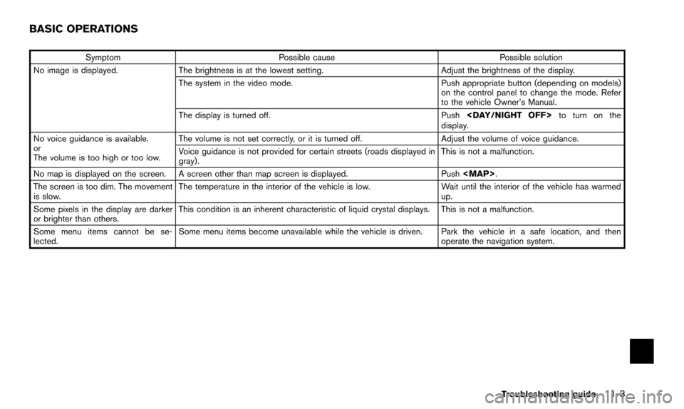
SymptomPossible cause Possible solution
No image is displayed. The brightness is at the lowest setting. Adjust the brightness of the display.
The system in the video mode. Push appropriate button (depending on models)
on the control panel to change the mode. Refer
to the vehicle Owner’s Manual.
The display is turned off. Push
display.
No voice guidance is available.
or
The volume is too high or too low. The volume is not set correctly, or it is turned off.
Adjust the volume of voice guidance.
Voice guidance is not provided for certain streets (roads displayed in
gray). This is not a malfunction.
No map is displayed on the screen. A screen other than map screen is displayed. Push
Page 220 of 241
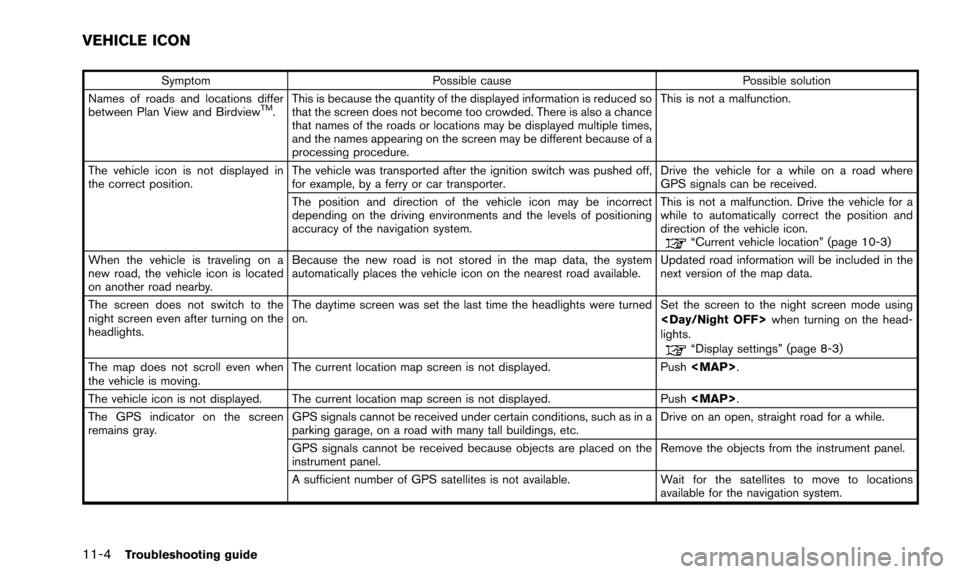
11-4Troubleshooting guide
SymptomPossible cause Possible solution
Names of roads and locations differ
between Plan View and Birdview
TM. This is because the quantity of the displayed information is reduced so
that the screen does not become too crowded. There is also a chance
that names of the roads or locations may be displayed multiple times,
and the names appearing on the screen may be different because of a
processing procedure. This is not a malfunction.
The vehicle icon is not displayed in
the correct position. The vehicle was transported after the ignition switch was pushed off,
for example, by a ferry or car transporter. Drive the vehicle for a while on a road where
GPS signals can be received.
The position and direction of the vehicle icon may be incorrect
depending on the driving environments and the levels of positioning
accuracy of the navigation system. This is not a malfunction. Drive the vehicle for a
while to automatically correct the position and
direction of the vehicle icon.
“Current vehicle location” (page 10-3)
When the vehicle is traveling on a
new road, the vehicle icon is located
on another road nearby. Because the new road is not stored in the map data, the system
automatically places the vehicle icon on the nearest road available.
Updated road information will be included in the
next version of the map data.
The screen does not switch to the
night screen even after turning on the
headlights. The daytime screen was set the last time the headlights were turned
on.
Set the screen to the night screen mode using
when turning on the head-
lights.
“Display settings” (page 8-3)
The map does not scroll even when
the vehicle is moving. The current location map screen is not displayed. Push