ESP NISSAN LEAF 2013 1.G Navigation Manual
[x] Cancel search | Manufacturer: NISSAN, Model Year: 2013, Model line: LEAF, Model: NISSAN LEAF 2013 1.GPages: 275, PDF Size: 6.66 MB
Page 232 of 275

10-6Troubleshooting guide/General system information
Energy information display
SymptomPossible cause Possible solution
The instant value shown on the energy economy
information continues to show the maximum value. This is due to power stored by the cooperative
regenerative brake being used.Battery power is stored by the cooperative regenerative
brake while driving. While this occurs, the instant value
will be displayed as the maximum. The maximum value
will be displayed until the regenerated power is
consumed.
The driving range increase/decrease when the air
conditioner/heater is ON/OFF that is displayed in the
energy usage information screen is displayed as +0
mile (+0 km) or -0 mile (-0 km). The power used for the air conditioner/heater will
decrease in response to the power used by the traction
motor and the increase/decrease difference of the
driving range will be under ±1 mile (±1 km). Also, when
the Li-ion battery available charge is low, the increase/
decrease of the driving range will also become smaller.This is not a malfunction.
Page 239 of 275

SymptomPossible cause Possible solution
An indirect route is suggested. If there are restrictions (such as one-way streets) on roads close to the starting point or destination, the system may suggest an indirect route. Adjust the location of the starting point or destination.
The system may suggest an indirect route because route calculation
does not take into consideration some areas such as narrow streets
(gray roads) . Reset the destination to a main or ordinary road, and
recalculate the route.
The landmark information does not
correspond to the actual information. This may be caused by insufficient or incorrect map data.
Updated information will be included in the next version
of the map data.
The suggested route does not exactly
connect to the starting point, waypoints,
or destination. There is no data for route calculation closer to these locations. Set the starting point, waypoints and destination on a
main road, and perform route calculation.
Troubleshooting guide/General system information10-13
Page 240 of 275
10-14Troubleshooting guide/General system information
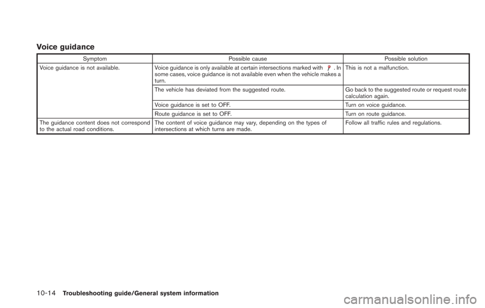
Voice guidance
SymptomPossible cause Possible solution
Voice guidance is not available. Voice guidance is only available at certain intersections marked with
.In
some cases, voice guidance is not available even when the vehicle makes a
turn. This is not a malfunction.
The vehicle has deviated from the suggested route. Go back to the suggested route or request route calculation again.
Voice guidance is set to OFF. Turn on voice guidance.
Route guidance is set to OFF. Turn on route guidance.
The guidance content does not correspond
to the actual road conditions. The content of voice guidance may vary, depending on the types of
intersections at which turns are made. Follow all traffic rules and regulations.
Page 242 of 275

10-16Troubleshooting guide/General system information
CARWINGSTM
SymptomPossible cause Possible solution
The system cannot connect to the
NISSAN CARWINGS Data Center. A subscription for the CARWINGSTMservice has not been
established. Sign up for a subscription to the CARWINGSTMservice. For details
about subscriptions, contact a NISSAN certified LEAF dealer.
The user ID and password are not entered. Enter the user ID and password.
“Inputting user ID and password” (page 1-11)
The communication line is busy. Try again after a short period of time.
The vehicle is in a location where it is difficult to receive radio
waves. When the vehicle moves to an area where radio waves can be
transmitted sufficiently, communication will be restored. When the
icon on the display shows that the vehicle is inside the
communication area, the system can be used.
TCU is not turned on. If the icon does not show that the vehicle is inside the communication area despite the fact that the vehicle is in that
location, contact a NISSAN certified LEAF dealer.
Radio wave reception is not sufficient for TCU operation. When the vehicle moves to an area where radio waves can be transmitted sufficiently, communication will be restored. When the
icon on the display shows that the vehicle is inside the
communication area, the system can be used.
Communication may sometimes not be possible even when
the network status is good. Signing in again may restore the connection.
Some of the items that are displayed
on the menu screen cannot be se-
lected. The vehicle is being driven and some menu items are
disabled.
The vehicle is being driven. Stop the vehicle in a safe location and
apply the parking brake before operating the functions.
“Functions disabled while driving” (page 1-6)
Some parts of the screen are not
displayed. The vehicle is being driven and some menu items are
disabled. Operate the system after stopping the vehicle in a safe location and
applying the parking brake.
“Functions disabled while driving” (page 1-6)
The system does not announce in-
formation. The volume level is set to the minimum.
Adjust the volume level by operating theVOLbuttons located on
the control panel or on the steering wheel switch while the system
is announcing information.
Page 245 of 275

iPod®player
SymptomPossible cause Possible solution
The system does not recognize an iPod®. A connector cable is not correctly connected, or the
iPod®does not correctly operate. Connect the connector cable again. If the system does
not recognize the iPod®after performing this procedure
above, reset the iPod®.
The iPod®that is to be connected is not compatible
with the system. Check the iPod®model and firmware versions available
for the system.
A USB extension cable is not correctly connected. Do not use a USB extension cable.
The cable is rapidly connected to or disconnected from
the USB connector. Slowly connect or disconnect the USB cable.
An iPod
®cannot be operated. The iPod®is connected to the in-vehicle audio system
while headsets, etc. are connected to the iPod®. Remove all equipment from the iPod
®after discon-
necting the iPod®from the system, and then connect it
to the system again.
The iPod
®is not operating normally. Disconnect the iPod®from the in-vehicle audio system,
and then connect it to the system again.
The system plays back an album/track that includes a
particular album art. Disconnect the iPod
®from the in-vehicle audio system,
and then reset the iPod®. Disable the album art, and
then connect the iPod®to the system.
An iPod®does not respond. There are too many tracks in a category. Decrease the number of tracks in a category (less than
3,000 tracks).
The shuffle function is turned on. Turn off the shuffle function if many tracks are stored on
the iPod
®.
Music cannot be played back. A connector is not connected to the iPod®. Firmly connect the connector until it clicks.
Playback cuts out. The sound cuts due to vibration resulting from unstable
location of the iPod
®. Place the iPod
®on a stable location where it does not
roll over.
Distorted sound occurs. The EQ (equalizer) function of the iPod
®is turned on. Turn off the EQ (equalizer) function.
Battery charge of an iPod®takes longer. Battery charge of the iPod®may take longer while an
iPod®is playing back. If the iPod
®is requires charging, it is recommended to
stop play back.
Battery charge of an iPod
®is unavailable. The cable that is connected to the iPod®may
deteriorate (cable disconnection, etc.). Check the cable currently in use.
Troubleshooting guide/General system information10-19
Page 249 of 275
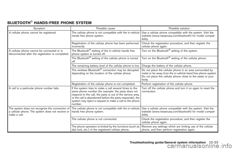
BLUETOOTH®HANDS-FREE PHONE SYSTEM
SymptomPossible cause Possible solution
A cellular phone cannot be registered. The cellular phone is not compatible with the in-vehicle
hands free phone system. Use a cellular phone compatible with the system. Visit the
website (www.nissanusa.com/bluetooth) for model compat-
ibility.
Registration of the cellular phone has been performed
incorrectly. Check the registration procedure, and then register the
cellular phone again.
A cellular phone cannot be connected or is
disconnected after the registration is completed. The Bluetooth
®setting of the in-vehicle hands free
phone system is turned off. Turn on the Bluetooth®setting of the system.
The Bluetooth
®setting of the cellular phone is turned
off. Turn on the Bluetooth®setting of the cellular phone.
The remaining battery level of the cellular phone is low. Charge the battery of the cellular phone.
The wireless Bluetooth
®connection may be disrupted
depending on the location of the cellular phone. Do not place the cellular phone in an area surrounded by
metal or far away from the in-vehicle hand free phone system.
Do not place the cellular phone close to the seats or your
body.
Registration of the cellular phone is not completed. Perform registration of the cellular phone.
A call to a particular phone number fails. If the system tries to make a call several times to the same phone number (for example: the party does not
respond to the call, the party is out of the service area,
or the call is abandoned before the party responds) , the
system may reject a request to make a call to the phone
number. Turn off the cellular phone and turn it on again to reset the
connection.
The system does not recognize the connection of
a cellular phone. The system does not receive or
make a call. The cellular phone is not compatible with the in-vehicle
hands free phone system.
Use a cellular phone compatible with the system. Visit the
website (www.nissanusa.com/bluetooth) for model compat-
ibility.
The cellular phone is not connected. Check the registration procedure, and then register the
cellular phone again.
The phone operation is limited by the functions (such as
dial lock, etc.) of the registered cellular phone. Remove any settings which are limiting use of the cellular
phone, and then perform registration again.
Troubleshooting guide/General system information10-23
Page 255 of 275
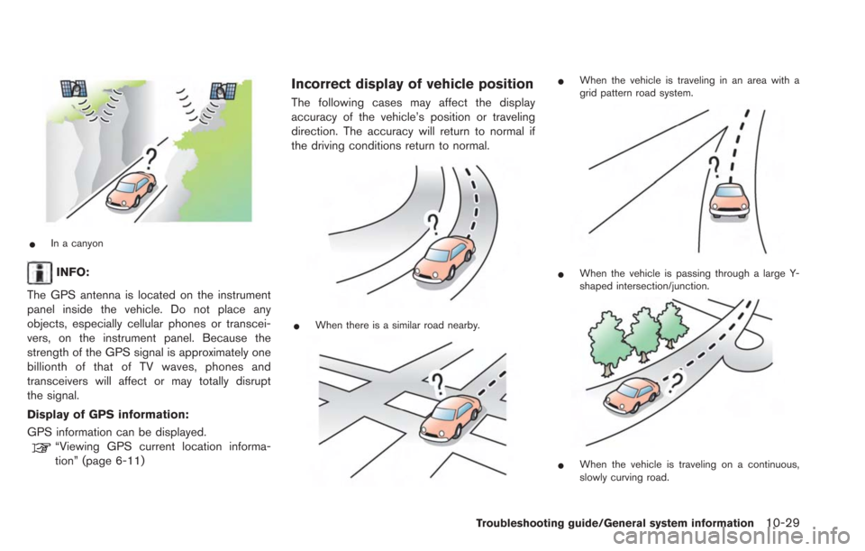
*In a canyon
INFO:
The GPS antenna is located on the instrument
panel inside the vehicle. Do not place any
objects, especially cellular phones or transcei-
vers, on the instrument panel. Because the
strength of the GPS signal is approximately one
billionth of that of TV waves, phones and
transceivers will affect or may totally disrupt
the signal.
Display of GPS information:
GPS information can be displayed.
“Viewing GPS current location informa-
tion” (page 6-11)
Incorrect display of vehicle position
The following cases may affect the display
accuracy of the vehicle’s position or traveling
direction. The accuracy will return to normal if
the driving conditions return to normal.
*When there is a similar road nearby.
*When the vehicle is traveling in an area with a
grid pattern road system.
*When the vehicle is passing through a large Y-
shaped intersection/junction.
*When the vehicle is traveling on a continuous,
slowly curving road.
Troubleshooting guide/General system information10-29
Page 259 of 275
of the vehicle icon is automatically
adjusted before recalculating the route.
— There are cases in which the system shows an indirect route to reach the
destination or waypoints, if you set them
from stored or facility information. In
order to correct this, you must be careful
about the traffic direction, especially
when lanes with different travel directions
are shown separately, such as inter-
changes and service areas.
— This system makes no distinction be- tween limited traffic control and total
control (blockage) . It may show an
indirect route even if the road is usable.
— Even if the freeway preference is set to OFF, a route that uses the freeway may
be suggested.
— Even if the ferry preference is set to OFF, a route that uses a ferry line may be
suggested.
— Ferry lines, excluding those that are only for pedestrians, bicycles and motor-
cycles, are stored in this system. Take
into consideration the travel time required
and operational condition before decid-
ing whether to use them or not.ROUTE GUIDANCE
INFO:
The system will only announce street names
when the system language is set to English.
Street names are not announced when the
system is set to Franc¸ ais (French).
Basics of voice guidance
Voice guidance announces which direction to
turn when approaching an intersection in which
a turn is necessary.
INFO:
. There may be some cases in which voice
guidance and actual road conditions do not
correspond. This may occur because of
discrepancies between the actual road and
the information on the map data, or it is due
to the vehicle’s speed.
. In case voice guidance does not correspond
to the actual road conditions, follow the
information obtained from traffic signs or
notices on the road.
. Route guidance provided by the navigation
system does not take carpool lane driving
into consideration, especially when carpool
lanes are separated from other road lanes.
Directions provided and distances
to guide points
Directions will differ, depending on the road
type.
INFO:
Distances may vary, depending on the vehicle
speed.
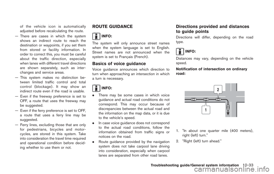
Notification of intersection on ordinary
road:
1. "In about one quarter mile (400 meters) , right (left) turn."
2. "Right (left) turn ahead."
Troubleshooting guide/General system information10-33
Page 263 of 275
where road data is not complete, voice
guidance may stop for long periods of time.
Be sure to follow the actual traffic restric-
tions while driving.
NOTES ON NAV TRAFFIC INFOR-
MATION
.The NavTraffic information service is not
provided for some cities. In addition, the
cities for which the traffic information service
is provided may be changed.
. In some cases, infrastructure problems may
prevent the complete display of the traffic
information. This is not a malfunction.
. Due to infrastructure problems, or due to the
time when the traffic information service
broadcast is received, the displayed infor-
mation may differ from the actual traffic
conditions.
. Depending on the traffic information, a
detour route may be slower than the original
route.
. NavTraffic is a service of SiriusXM Satellite
Radio. NavTraffic is only available in select
markets and is subject to data availability.
Reception of the XM
®signal may vary
depending on location. It requires a monthly
premium subscription. The service provider
is solely responsible for the quality and accuracy of the information provided. All
fees and programming are subject to
change. For more details on the NavTraffic
service, terms and conditions, please visit
www.siriusxm.com/navtraffic.
You can also contact SiriusXM Satellite
Radio at
1-866-635-2349.
. As of January 31, 2009, the NavTraffic
service covers 80 major metropolitan mar-
kets. For the most current list of markets
covered, please refer to
www.siriusxm.com/navtraffic, or call Sir-
iusXM Satellite Radio customer support at
1-866-635-2349.
. Due to road maintenance, infrastructure
problems (e.g. malfunction of road sensors,
outage of central computer of infrastructure)
or natural disasters, there are times when
some or all traffic information may not be
available.
. Incident information is based on human
collection. Not all incidents that have hap-
pened are collected and provided.
. Due to infrastructure problems, or transmis-
sion delay, there are times when the
information may differ from the actual con-
dition. Always observe safe driving practices
and follow all traffic regulations. .
Due to the coverage and quality of traffic
information and road conditions, it is not
always possible for the system to provide
the shortest time route even when traffic
information is considered.
. Traffic information that is displayed may
differ from information from other media
(e.g., radio) , as other media may use
different information sources.
MAP DATA
How to handle the Map SD card
In the right side slot, an SD card that includes
the map data is inserted. When handling the
Map SD card, please be careful and adhere to
the following instructions:
.An SD card is inserted in the slot on the
right side. This is the SDHC card that is
exclusively used for this device. This card
includes the map data. The SDHC card is
necessary to operate the device. Do not
remove this card except when update of the
map data is required.
. The device does not work even if the SDHC
card with the map data is inserted in the slot
on the left side.
. Never analyze, modify, delete or format the
map data. Doing so may cause an improper
operation of the device.
Troubleshooting guide/General system information10-37
Page 265 of 275
listing of emergency services such
as police stations, fire halls, hospi-
tals and walk-in clinics. Please
show discretion and ask for direc-
tions in such instances.
. As the driver, you alone are respon-
sible for your driving safety.
— In order to avoid a traffic acci-
dent, do not operate the system
while driving.
— In order to avoid a traffic acci- dent, operate the system only
when the vehicle is stopped at a
safe place and the parking
brake is on.
— In order to avoid a traffic acci- dent or traffic offence, remem-
ber that actual road conditions
and traffic regulations take pre-
cedence over the information
contained on the navigation sys-
tem.
— The Software may contain inac- curate or incomplete informa-
tion due to the passage of
time, changing circumstances,
and the sources of information
used. Please respect current traffic conditions and regula-
tions at all times while driving.
— Where actual road conditions and highway regulations differ
from the information contained
on the navigation system, abide
by the highway regulations.
— Keep the amount of time spent viewing the screen while driving
to a strict minimum.
The navigation system does not provide,
nor represent in any way information on:
traffic and highway regulations; technical
aspects of the vehicle including weight,
height, width, load and speed limits; road
conditions including grade, percentage of
incline and surface conditions; obstacles
such as the height and width of bridges
and tunnels; and other current driving or
road conditions. Always rely on your own
judgement when driving a car, taking into
account current driving conditions.
The marks of companies displayed by this
product to indicate business locations are the
marks of their respective owners. The use of
such marks in this product does not imply any
sponsorship, approval, or endorsement by such companies of this product.
End-user terms
The data (“Data”) is provided for your personal,
internal use only and not for resale. It is
protected by copyright, and is subject to the
following terms and conditions which are agreed
to by you, on the one hand, and HITACHI
AUTOMOTIVE SYSTEMS, LTD. (“HITACHI”)
and its licensors (including their licensors and
suppliers) on the other hand.
*C2010 NAVTEQ. All rights reserved.
The Data for areas of Canada includes informa-
tion taken with permission from Canadian
authorities, including:
*CHer Majesty the Queen
in Right of Canada,*CQueen’s Printer for
Ontario,*CCanada Post Corporation, Geo-
Base®,*CDepartment of Natural Resources
Canada.
NAVTEQ holds a non-exclusive license from the
United States Postal Service
®to publish and
sell ZIP+4®information.
*CUnited States Postal Service®2010. Prices
are not established, controlled or approved by
the United States Postal Service
®. The following
trademarks and registrations are owned by the
USPS: United States Postal Service, USPS, and
ZIP+4.
Troubleshooting guide/General system information10-39