light NISSAN MAXIMA 2004 A34 / 6.G Navigation Manual
[x] Cancel search | Manufacturer: NISSAN, Model Year: 2004, Model line: MAXIMA, Model: NISSAN MAXIMA 2004 A34 / 6.GPages: 186, PDF Size: 4.27 MB
Page 73 of 186
![NISSAN MAXIMA 2004 A34 / 6.G Navigation Manual The [EDIT ROUTE] screen will be displayed.
2. Select a waypoint destination using one of
the destination selection procedures out-
lined earlier in the chapter.Select the conditions with high prioriti NISSAN MAXIMA 2004 A34 / 6.G Navigation Manual The [EDIT ROUTE] screen will be displayed.
2. Select a waypoint destination using one of
the destination selection procedures out-
lined earlier in the chapter.Select the conditions with high prioriti](/img/5/674/w960_674-72.png)
The [EDIT ROUTE] screen will be displayed.
2. Select a waypoint destination using one of
the destination selection procedures out-
lined earlier in the chapter.Select the conditions with high priorities.
If you want to get to your destination in the short-
est time, select the
Shortest Time key.
Selecting the key will turn the indicator light in
the key ON; selecting it again will turn it OFF.
INFO:
cWhen you select the
OK key at this point,
route calculation will start without any addi-
tional waypoints.
cPress the PREV button to display the [EDIT
ROUTE] screen.cIt is also possible to set a waypoint by select-
ing the
Waypoint key in the [DEST. SET-
TING] screen.
Setting the priorities for route calcula-
tion
After the setting of destinations and waypoints is
completed, set the calculation conditions such
as route type with high priorities.
INV1859INV1857
How do I program a destination?5-33
ZREVIEW COPYÐ2004 Maxima(max)
Navigation System OM(navi)ÐUSA_English(nna)
04/27/04Ðtbrooks
X
Page 74 of 186
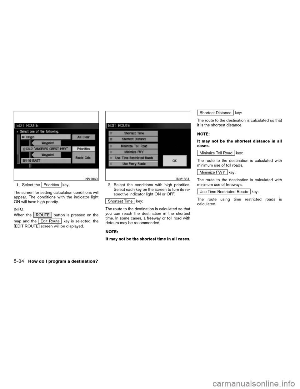
1. Select thePriorities key.
The screen for setting calculation conditions will
appear. The conditions with the indicator light
ON will have high priority.
INFO:
When the ROUTE button is pressed on the
map and the
Edit Route key is selected, the
[EDIT ROUTE] screen will be displayed.2. Select the conditions with high priorities.
Select each key on the screen to turn its re-
spective indicator light ON or OFF.
Shortest Time key:
The route to the destination is calculated so that
you can reach the destination in the shortest
time. In some cases, a freeway or toll road with
detours may be recommended.
NOTE:
It may not be the shortest time in all cases.
Shortest Distance key:
The route to the destination is calculated so that
it is the shortest distance.
NOTE:
It may not be the shortest distance in all
cases.
Minimize Toll Road key:
The route to the destination is calculated with
minimum use of toll roads.
Minimize FWY key:
The route to the destination is calculated with
minimum use of freeways.
Use Time Restricted Roads key:
The route using time restricted roads is
calculated.
INV1860INV1861
5-34How do I program a destination?
ZREVIEW COPYÐ2004 Maxima(max)
Navigation System OM(navi)ÐUSA_English(nna)
04/27/04Ðtbrooks
X
Page 103 of 186
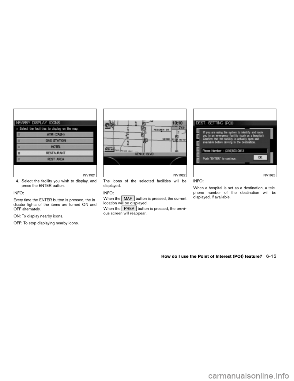
4. Select the facility you wish to display, and
press the ENTER button.
INFO:
Every time the ENTER button is pressed, the in-
dicator lights of the items are turned ON and
OFF alternately.
ON: To display nearby icons.
OFF: To stop displaying nearby icons.The icons of the selected facilities will be
displayed.
INFO:
When the MAP button is pressed, the current
location will be displayed.
When the PREV button is pressed, the previ-
ous screen will reappear.INFO:
When a hospital is set as a destination, a tele-
phone number of the destination will be
displayed, if available.
INV1921INV1922INV1923
How do I use the Point of Interest (POI) feature?6-15
ZREVIEW COPYÐ2004 Maxima(max)
Navigation System OM(navi)ÐUSA_English(nna)
04/27/04Ðtbrooks
X
Page 111 of 186
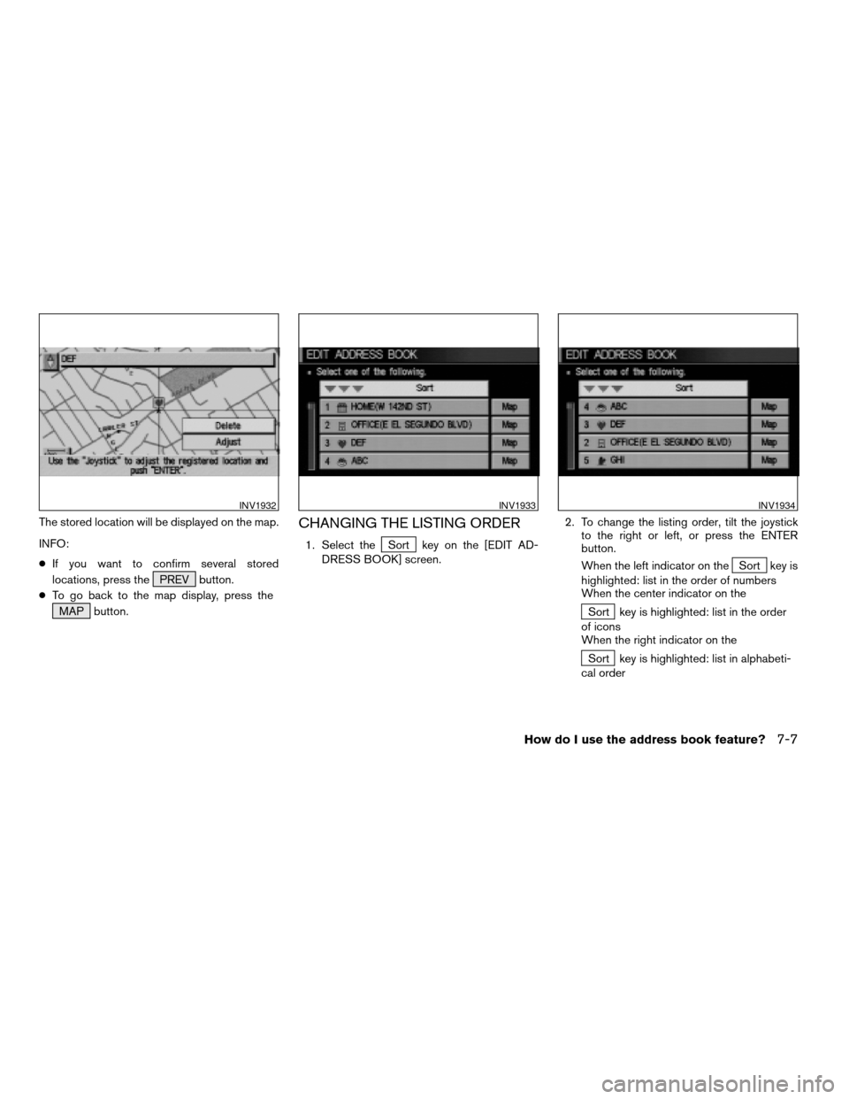
The stored location will be displayed on the map.
INFO:
cIf you want to confirm several stored
locations, press the PREV button.
cTo go back to the map display, press the
MAP button.CHANGING THE LISTING ORDER
1. Select theSort key on the [EDIT AD-
DRESS BOOK] screen.2. To change the listing order, tilt the joystick
to the right or left, or press the ENTER
button.
When the left indicator on the
Sort key is
highlighted: list in the order of numbers
When the center indicator on the
Sort key is highlighted: list in the order
of icons
When the right indicator on the
Sort key is highlighted: list in alphabeti-
cal order
INV1932INV1933INV1934
How do I use the address book feature?7-7
ZREVIEW COPYÐ2004 Maxima(max)
Navigation System OM(navi)ÐUSA_English(nna)
04/27/04Ðtbrooks
X
Page 139 of 186
DIRECTIONS GIVEN AND THE DIS-
TANCE TO THE ROAD POINTS
Directions will differ depending on road type.
INFO:
Distances may vary depending on vehicle speed.
NOTIFICATION OF AN INTERSEC-
TION ON AN ORDINARY ROAD
“In a quarter mile (400 meters) , right (left) turn.”
“Right (left) turn ahead.”
NOTIFICATION OF CONSECUTIVE
INTERSECTIONS ON AN ORDINARY
ROAD
“In a quarter mile (400 meters) , right (left) turn,
then left (right) turn.”
“Right (left) turn ahead, then left (right) turn.”
NOTIFICATION OF AN ENTRANCE
TO A FREEWAY
“In a quarter mile (400 meters) freeway entrance
on your right onto (road number and direction) .”
“Freeway entrance on your right onto (road num-
ber and direction) .”
NOTIFICATION OF A FREEWAY
JUNCTION
“In about one mile (1.6 kilometers) , keep to the
right (left) onto (road number and direction) ,
then in a quarter mile keep to the left (right) .”
“Keep to the right (left) onto (road number and
direction) , then in a quarter mile (400 meters)
keep to the left (right) onto (road number and
direction) .”
“Keep to the left (right) onto (road number and
direction) .”
NOTIFICATION OF AN EXIT FROM A
FREEWAY
“In about one mile (1.6 kilometers) , exit on your
right.”
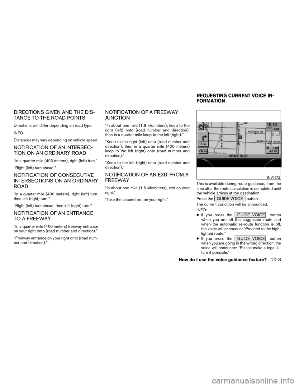
“Take the second exit on your right.”This is available during route guidance, from the
time after the route calculation is completed until
the vehicle arrives at the destination.
Press the GUIDE VOICE button.
The current condition will be announced.
INFO:
cIf you press the GUIDE VOICE button
when you are off the suggested route and
when the automatic re-route function is off,
the voice will announce: “Proceed to the high-
lighted route.”
cIf you press the GUIDE VOICE button
when you are going in the wrong direction, the
voice will announce: “Please make a legal U-
turn if possible.”
INV1972
REQUESTING CURRENT VOICE IN-
FORMATION
How do I use the voice guidance feature?10-3
ZREVIEW COPYÐ2004 Maxima(max)
Navigation System OM(navi)ÐUSA_English(nna)
04/27/04Ðtbrooks
X
Page 149 of 186
![NISSAN MAXIMA 2004 A34 / 6.G Navigation Manual INFO:
cWhen the key is selected, the amber indicator
light will light up.
cWhen the MAP button is pressed after the
display setting, the [CURRENT LOCATION]
screen will appear.
When the PREV button is NISSAN MAXIMA 2004 A34 / 6.G Navigation Manual INFO:
cWhen the key is selected, the amber indicator
light will light up.
cWhen the MAP button is pressed after the
display setting, the [CURRENT LOCATION]
screen will appear.
When the PREV button is](/img/5/674/w960_674-148.png)
INFO:
cWhen the key is selected, the amber indicator
light will light up.
cWhen the MAP button is pressed after the
display setting, the [CURRENT LOCATION]
screen will appear.
When the PREV button is pressed, the
previous screen will reappear.You can manually scroll the map to check the lo-
cation of your choice.
1. Operating the joystick.
The map scrolls in the same direction as the joy-
stick movement.
INFO:
While the vehicle is traveling, a single operation
will move within the displayed area of the screen.
2. Press the MAP button to go back and
show the current vehicle position.
INFO:
You can also select the PREV button to go
back.
Display with the forward direction up
INV1984INV1985
SCROLLING THE MAP
How do I adjust the display?11-9
ZREVIEW COPYÐ2004 Maxima(max)
Navigation System OM(navi)ÐUSA_English(nna)
04/27/04Ðtbrooks
X
Page 152 of 186
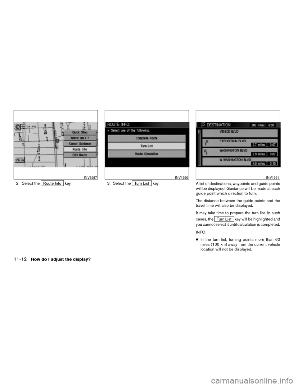
2. Select theRoute Info key. 3. Select theTurn List key.
A list of destinations, waypoints and guide points
will be displayed. Guidance will be made at each
guide point which direction to turn.
The distance between the guide points and the
travel time will also be displayed.
It may take time to prepare the turn list. In such
cases, the
Turn List key will be highlighted and
you cannot select it until calculation is completed.
INFO:
cIn the turn list, turning points more than 60
miles (100 km) away from the current vehicle
location will not be displayed.
INV1987INV1990INV1991
11-12How do I adjust the display?
ZREVIEW COPYÐ2004 Maxima(max)
Navigation System OM(navi)ÐUSA_English(nna)
04/27/04Ðtbrooks
X
Page 166 of 186
To order updated mapping DVD-ROMs or addi-
tional DVD-ROMs, please contact the NISSAN
Navigation System help desk at:
cADDRESS: P .O. Box 2082, Burlingame, CA
94011
cE-MAIL: [email protected]
cWEB SITE: www.zenrin.com
cPHONE: 1-888-661-9995
cHOURS: 6:00 AM to 5:00 PM (Pacific Time)
CAUTION
cHandle a DVD-ROM by its edges.
Never touch the surface of the disc.
cTo clean a disc, wipe the surface
from the center to the outer edge us-
ing a clean, soft cloth. Do not wipe
the disc using a circular motion.
Do not use a conventional record
cleaner, benzine, thinner or alcohol
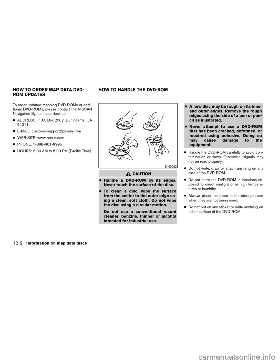
intended for industrial use.cA new disc may be rough on its inner
and outer edges. Remove the rough
edges using the side of a pen or pen-
cil as illustrated.
cNever attempt to use a DVD-ROM
that has been cracked, deformed, or
repaired using adhesive. Doing so
may cause damage to the
equipment.
cHandle the DVD-ROM carefully to avoid con-
tamination or flaws. Otherwise, signals may
not be read properly.
cDo not write, draw or attach anything on any
side of the DVD-ROM.
cDo not store the DVD-ROM in locations ex-
posed to direct sunlight or in high tempera-
tures or humidity.
cAlways place the discs in the storage case
when they are not being used.
cDo not put on any sticker or write anything on
either surface of the DVD-ROM.
SIH0082
HOW TO ORDER MAP DATA DVD-
ROM UPDATESHOW TO HANDLE THE DVD-ROM
12-2Information on map data discs
ZREVIEW COPYÐ2004 Maxima(max)
Navigation System OM(navi)ÐUSA_English(nna)
04/27/04Ðtbrooks
X
Page 176 of 186
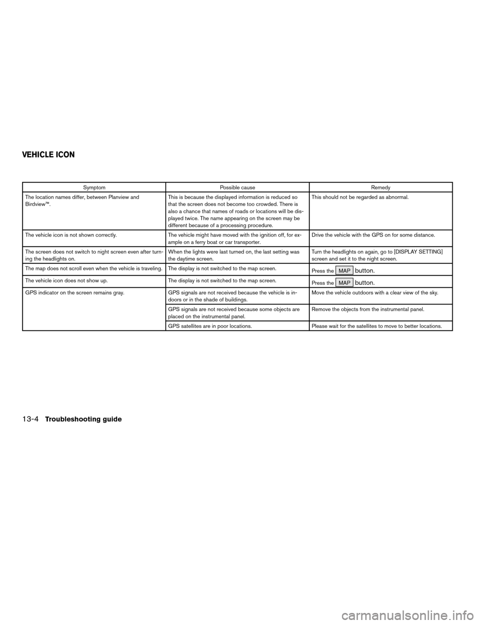
Symptom Possible cause Remedy
The location names differ, between Planview and
Birdview™.This is because the displayed information is reduced so
that the screen does not become too crowded. There is
also a chance that names of roads or locations will be dis-
played twice. The name appearing on the screen may be
different because of a processing procedure.This should not be regarded as abnormal.
The vehicle icon is not shown correctly. The vehicle might have moved with the ignition off, for ex-
ample on a ferry boat or car transporter.Drive the vehicle with the GPS on for some distance.
The screen does not switch to night screen even after turn-
ing the headlights on.When the lights were last turned on, the last setting was
the daytime screen.Turn the headlights on again, go to [DISPLAY SETTING]
screen and set it to the night screen.
The map does not scroll even when the vehicle is traveling. The display is not switched to the map screen.
Press the MAP
button.
The vehicle icon does not show up. The display is not switched to the map screen.
Press the MAPbutton.
GPS indicator on the screen remains gray. GPS signals are not received because the vehicle is in-
doors or in the shade of buildings.Move the vehicle outdoors with a clear view of the sky.
GPS signals are not received because some objects are
placed on the instrumental panel.Remove the objects from the instrumental panel.
GPS satellites are in poor locations. Please wait for the satellites to move to better locations.
VEHICLE ICON
13-4Troubleshooting guide
ZREVIEW COPYÐ2004 Maxima(max)
Navigation System OM(navi)ÐUSA_English(nna)
04/27/04Ðtbrooks
X
Page 181 of 186
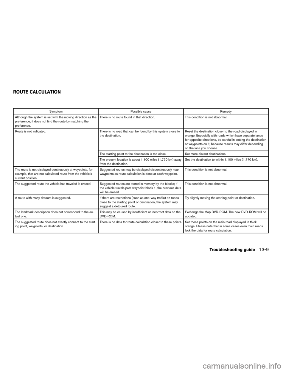
Symptom Possible cause Remedy
Although the system is set with the moving direction as the
preference, it does not find the route by matching the
preference.There is no route found in that direction. This condition is not abnormal.
Route is not indicated. There is no road that can be found by this system close to
the destination.Reset the destination closer to the road displayed in
orange. Especially with roads which have separate lanes
for opposite directions, be careful in setting the destination
or waypoints on it, because results may differ depending
on the lane you choose.
The starting point to the destination is too close. Set more distant destinations.
The present location is about 1,100 miles (1,770 km) away
from the destination.Set the destination to within 1,100 miles (1,770 km) .
The route is not displayed continuously at waypoints, for
example, that are not calculated route from the vehicle’s
current position.Suggested routes may be displayed discontinuously near
waypoints as route calculation is done at each waypoint.This condition is not abnormal.
The suggested route the vehicle has traveled is erased. Suggested routes are stored in memory by the blocks; if
the vehicle travels past waypoint block 1, the previous data
will be erased.This condition is not abnormal.
A route with many detours is suggested. If there are restrictions (such as one-way traffic) on roads
close to the starting point or destination, the system may
suggest a detoured route.Try slightly moving the starting point or destination.
The landmark description does not correspond to the ac-
tual one.This may be caused by insufficient or incorrect data on the
DVD-ROM.Exchange the Map DVD-ROM. The new DVD-ROM will be
updated.
The suggested route does not exactly connect to the start-
ing point, waypoints, or destination.There is no data for route calculation closer to these points. Set these points on the main road displayed in thick
orange. Please note that in some cases even main roads
lack the data for route calculation.
ROUTE CALCULATION
Troubleshooting guide13-9
ZREVIEW COPYÐ2004 Maxima(max)
Navigation System OM(navi)ÐUSA_English(nna)
04/27/04Ðtbrooks
X