reset NISSAN MAXIMA 2004 A34 / 6.G Navigation Manual
[x] Cancel search | Manufacturer: NISSAN, Model Year: 2004, Model line: MAXIMA, Model: NISSAN MAXIMA 2004 A34 / 6.GPages: 186, PDF Size: 4.27 MB
Page 27 of 186
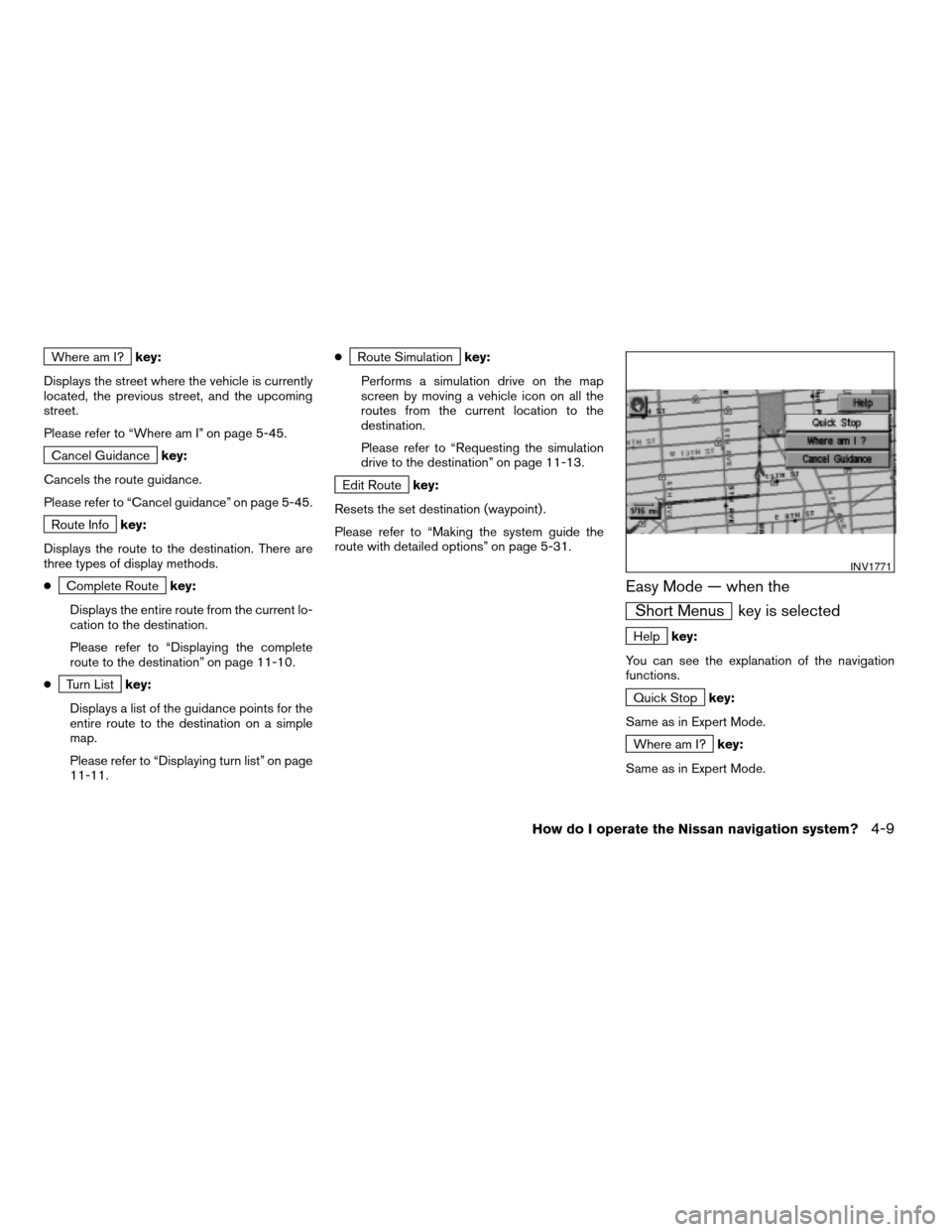
Where am I?key:
Displays the street where the vehicle is currently
located, the previous street, and the upcoming
street.
Please refer to “Where am I” on page 5-45.
Cancel Guidancekey:
Cancels the route guidance.
Please refer to “Cancel guidance” on page 5-45.
Route Infokey:
Displays the route to the destination. There are
three types of display methods.
c
Complete Routekey:
Displays the entire route from the current lo-
cation to the destination.
Please refer to “Displaying the complete
route to the destination” on page 11-10.
c
Turn Listkey:
Displays a list of the guidance points for the
entire route to the destination on a simple
map.
Please refer to “Displaying turn list” on page
11-11.c
Route Simulationkey:
Performs a simulation drive on the map
screen by moving a vehicle icon on all the
routes from the current location to the
destination.
Please refer to “Requesting the simulation
drive to the destination” on page 11-13.
Edit Routekey:
Resets the set destination (waypoint) .
Please refer to “Making the system guide the
route with detailed options” on page 5-31.
Easy Mode — when the
Short Menus key is selected
Helpkey:
You can see the explanation of the navigation
functions.
Quick Stopkey:
Same as in Expert Mode.
Where am I?key:
Same as in Expert Mode.
INV1771
How do I operate the Nissan navigation system?4-9
ZREVIEW COPYÐ2004 Maxima(max)
Navigation System OM(navi)ÐUSA_English(nna)
04/27/04Ðtbrooks
X
Page 38 of 186
regulations. In such cases, follow the actual
information available.
cDuring route calculation, the map will not
scroll, however the vehicle icon will move with
the actual vehicle’s movement.
cDuring route calculation, buttons such as
MAP , DEST ,
( ZOOM OUT )
and
( ZOOM IN ) and the joystick will
be disabled.
cIn some cases, after the calculation is
complete, it may take some time to get the
calculated route on the display.
cWaypoints that have been passed will not be
covered by the re-routing calculation.
cIf you scroll the map while the suggested
route is being drawn, it may take more time to
finish drawing.
cIf waypoints are set, the system is calculating
multiple routes between waypoints
simultaneously, and the following may result:
– If one section (or more) of the routes be-
tween the waypoints is not found, none
of the route will be displayed.
– The route may not connect completely at
some waypoints.– The route may require a U-turn close to
some waypoints.
cRoute calculation may not be completed in
the following cases:
– If there is no main road within 3.1 miles
(5 km) from the vehicle, a message say-
ing so will appear on the screen. Try re-
questing route calculation when the ve-
hicle is closer to the main road.
– If there is no main road within 3.1 miles
(5 km) from the destination or waypoint,
a message saying so will appear on the
screen. Try setting the location closer to
the main road.
– If the vehicle is too close to the destina-
tion or if there are no branches of the
roads to the destination. A message say-
ing so will appear on the screen.
– If it is deemed impossible to reach the
destination or waypoints because of traf-
fic regulations, etc.
– If the only route to reach the destination
or waypoints is extremely complicated.
– If the destination, current vehicle position
or waypoint is within the avoid area.– If the setting of avoid areas covers the
routes to the destination, route calcula-
tion may not be possible.
cThe following may occur when the route is be-
ing displayed:
– If you are requesting a calculation from
the main road, the origin of the route may
not exactly match the current vehicle
position.
– If you are requesting a calculation to a
destination on the main road, the end of
the route may not exactly match the
destination.
– If you are requesting a calculation from
the main road, the system may show a
route from another main road. This may
be because the icon to show the current
vehicle position (vehicle icon) is not set
accurately. In that case, park the car in a
safe place and reset the vehicle icon, or
continue driving to see if the vehicle icon
appears on the main road before re-
questing route calculation again.
– There are cases in which the system
shows a detoured route to reach the
destination or waypoints, if you set them
from memory or facility information. In or-
der to correct this, you will have to be
4-20How do I operate the Nissan navigation system?
ZREVIEW COPYÐ2004 Maxima(max)
Navigation System OM(navi)ÐUSA_English(nna)
04/27/04Ðtbrooks
X
Page 76 of 186
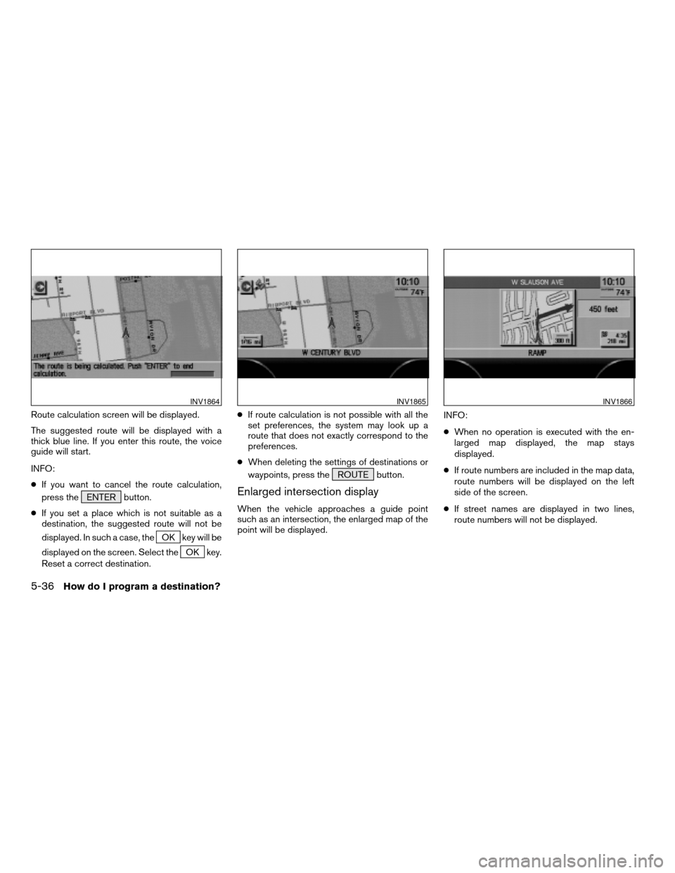
Route calculation screen will be displayed.
The suggested route will be displayed with a
thick blue line. If you enter this route, the voice
guide will start.
INFO:
cIf you want to cancel the route calculation,
press the ENTER button.
cIf you set a place which is not suitable as a
destination, the suggested route will not be
displayed. In such a case, the
OK key will be
displayed on the screen. Select the
OK key.
Reset a correct destination.cIf route calculation is not possible with all the
set preferences, the system may look up a
route that does not exactly correspond to the
preferences.
cWhen deleting the settings of destinations or
waypoints, press the ROUTE button.
Enlarged intersection display
When the vehicle approaches a guide point
such as an intersection, the enlarged map of the
point will be displayed.INFO:
cWhen no operation is executed with the en-
larged map displayed, the map stays
displayed.
cIf route numbers are included in the map data,
route numbers will be displayed on the left
side of the screen.
cIf street names are displayed in two lines,
route numbers will not be displayed.
INV1864INV1865INV1866
5-36How do I program a destination?
ZREVIEW COPYÐ2004 Maxima(max)
Navigation System OM(navi)ÐUSA_English(nna)
04/27/04Ðtbrooks
X
Page 80 of 186
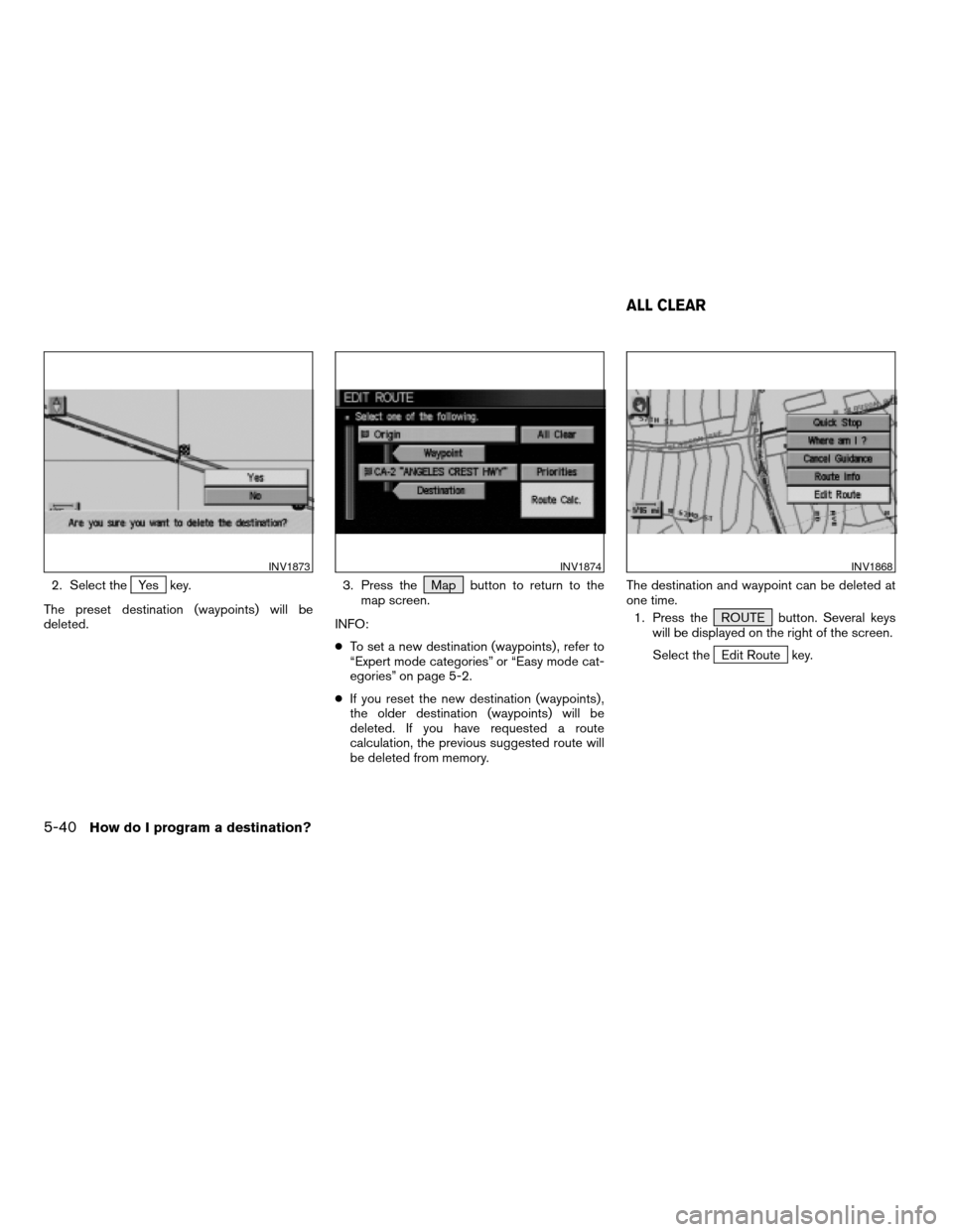
2. Select theYes key.
The preset destination (waypoints) will be
deleted.3. Press the Map button to return to the
map screen.
INFO:
cTo set a new destination (waypoints) , refer to
“Expert mode categories” or “Easy mode cat-
egories” on page 5-2.
cIf you reset the new destination (waypoints) ,
the older destination (waypoints) will be
deleted. If you have requested a route
calculation, the previous suggested route will
be deleted from memory.The destination and waypoint can be deleted at
one time.
1. Press the ROUTE button. Several keys
will be displayed on the right of the screen.
Select the
Edit Route key.
INV1873INV1874INV1868
ALL CLEAR
5-40How do I program a destination?
ZREVIEW COPYÐ2004 Maxima(max)
Navigation System OM(navi)ÐUSA_English(nna)
04/27/04Ðtbrooks
X
Page 156 of 186
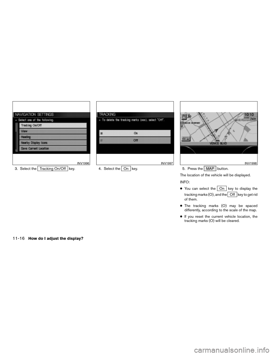
3. Select theTracking On/Off key. 4. Select theOn key. 5. Press the MAP button.
The location of the vehicle will be displayed.
INFO:
cYou can select the
On key to display the
tracking marks (O) , and the
Off key to get rid
of them.
cThe tracking marks (O) may be spaced
differently, according to the scale of the map.
cIf you reset the current vehicle location, the
tracking marks (O) will be cleared.
INV1996INV1997INV1998
11-16How do I adjust the display?
ZREVIEW COPYÐ2004 Maxima(max)
Navigation System OM(navi)ÐUSA_English(nna)
04/27/04Ðtbrooks
X
Page 181 of 186
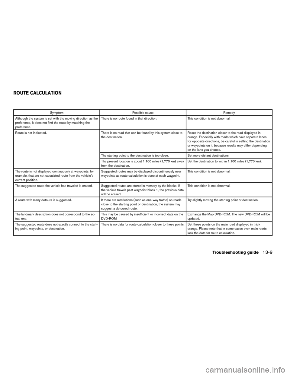
Symptom Possible cause Remedy
Although the system is set with the moving direction as the
preference, it does not find the route by matching the
preference.There is no route found in that direction. This condition is not abnormal.
Route is not indicated. There is no road that can be found by this system close to
the destination.Reset the destination closer to the road displayed in
orange. Especially with roads which have separate lanes
for opposite directions, be careful in setting the destination
or waypoints on it, because results may differ depending
on the lane you choose.
The starting point to the destination is too close. Set more distant destinations.
The present location is about 1,100 miles (1,770 km) away
from the destination.Set the destination to within 1,100 miles (1,770 km) .
The route is not displayed continuously at waypoints, for
example, that are not calculated route from the vehicle’s
current position.Suggested routes may be displayed discontinuously near
waypoints as route calculation is done at each waypoint.This condition is not abnormal.
The suggested route the vehicle has traveled is erased. Suggested routes are stored in memory by the blocks; if
the vehicle travels past waypoint block 1, the previous data
will be erased.This condition is not abnormal.
A route with many detours is suggested. If there are restrictions (such as one-way traffic) on roads
close to the starting point or destination, the system may
suggest a detoured route.Try slightly moving the starting point or destination.
The landmark description does not correspond to the ac-
tual one.This may be caused by insufficient or incorrect data on the
DVD-ROM.Exchange the Map DVD-ROM. The new DVD-ROM will be
updated.
The suggested route does not exactly connect to the start-
ing point, waypoints, or destination.There is no data for route calculation closer to these points. Set these points on the main road displayed in thick
orange. Please note that in some cases even main roads
lack the data for route calculation.
ROUTE CALCULATION
Troubleshooting guide13-9
ZREVIEW COPYÐ2004 Maxima(max)
Navigation System OM(navi)ÐUSA_English(nna)
04/27/04Ðtbrooks
X