navigation system NISSAN MAXIMA 2008 A34 / 6.G 04IT Navigation Manual
[x] Cancel search | Manufacturer: NISSAN, Model Year: 2008, Model line: MAXIMA, Model: NISSAN MAXIMA 2008 A34 / 6.GPages: 270, PDF Size: 5.97 MB
Page 4 of 270
Black plate (4,1)
Model "NISSAN_NAVI" EDITED: 2007/ 2/ 26
This manual uses special words, symbols and
icons, organized by function.
Please refer to the following items and familiarize
yourself with them.
Basic operations of the navigation system can
be performed in a similar manner for all vehicle
models. However, the map screen and setting
screen may be different for each model. Set the
navigation system as appropriate for your
vehicle.WARNING
This is used to indicate the presence of a
hazard that could cause death or serious
personal injury. To avoid or reduce the
risk, the procedures must be followed
precisely.
CAUTION
This is used to indicate the presence of a
hazard that could cause minor or mod-
erate personal injury or damage to your
vehicle. To avoid or reduce the risk, the
procedures must be followed carefully.
NOTE:
This indicates an item to help you under-
stand and maximize the performance of
your vehicle. If ignored, it may lead to a
malfunction or poor performance.
REFERENCE SYMBOLS
INFO:
This indicates information that is necessary for
efficient use of your vehicle or accessories.
Reference page:
This indicates the title and page that you should
refer to.
<>:
This indicates a button on the control panel.
[]:
This indicates a key/item displayed on the
screen.
HOW TO USE THIS MANUAL FOR SAFE OPERATION
1-2Introduction
Page 5 of 270
Black plate (5,1)
Model "NISSAN_NAVI" EDITED: 2007/ 2/ 26
This system is primarily designed to help you
reach your destination, and it also performs
other functions as outlined in this manual.
However, you, the driver, must use the system
safely and properly. Information concerning road
conditions, traffic signs and the availability of
services may not always be up-to-date. The
system is not a substitute for safe, proper and
legal driving.
Before using the navigation system, please read
the following safety information. Always use the
system as outlined in this manual.
WARNING
.When the driver wants to operate the
navigation system, first park the vehi-
cle in a safe location and set the
parking brake. Operating the system
while driving can distract the driver
and may result in a serious accident.
.Do not rely on route guidance alone.
Always be sure that all driving man-
euvers are legal and safe in order to
avoid accidents.
.Do not disassemble or modify this
system. If you do, it may result in
accidents, fire or electrical shock..Do not use this system if you notice
any malfunctions such as a frozen
screen or the lack of sound. Continued
use of the system may result in
accidents, fire or electrical shock.
.If you notice any foreign objects in the
system hardware, spill liquid on the
system or notice smoke or a smell
coming from it, stop using the system
immediately and contact a NISSAN
dealer. Ignoring such conditions may
lead to accidents, fire or electrical
shock.
CAUTION
.Do not keep the navigation system
running with the engine stopped.
Doing so may discharge the vehicle
battery. When you use the navigation
system, always keep the engine run-
ning.
.Some states/provinces may have laws
limiting the use of video screens while
driving. Use this system only where it
is legal to do so.
SAFETY INFORMATION
Introduction1-3
Page 6 of 270
Black plate (6,1)
Model "NISSAN_NAVI" EDITED: 2007/ 2/ 26
This navigation system is certified as a Class 1
laser product.
The navigation system complies with DHHS
Rules 21 CFR Chapter 1, Subchapter J.
WARNING
.Do not disassemble or modify this
system. There are no user serviceable
parts in this navigation system.
.If maintenance, adjustments and op-
erations other than those specified in
this manual are attempted, injury due
to laser radiation and exposure could
occur.
LASER PRODUCT
1-4Introduction
Page 10 of 270

Black plate (10,1)
Model "NISSAN_NAVI" EDITED: 2007/ 2/ 26
NAI0403
350Z
&1
Page 12 of 270
Black plate (12,1)
Model "NISSAN_NAVI" EDITED: 2007/ 2/ 26
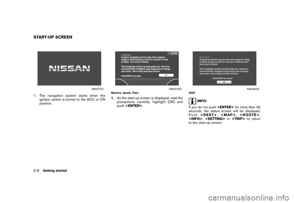
NAV2701
1. The navigation system starts when the
ignition switch is turned to the ACC or ON
position.
NAV2702Maxima, Quest, Titan
2. As the start-up screen is displayed, read the
precautions carefully, highlight [OK] and
push
NAV3022350Z
INFO:
If you do not push
seconds, the status screen will be displayed.
Push
Page 19 of 270
Black plate (19,1)
Model "NISSAN_NAVI" EDITED: 2007/ 2/ 26
NAV2707
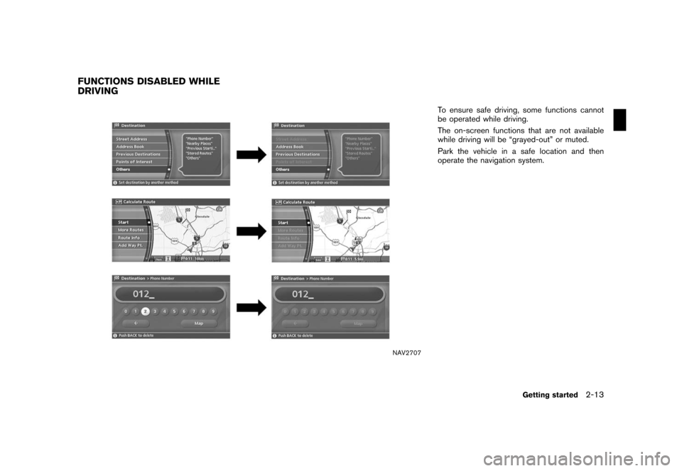
To ensure safe driving, some functions cannot
be operated while driving.
The on-screen functions that are not available
while driving will be “grayed-out” or muted.
Park the vehicle in a safe location and then
operate the navigation system.
FUNCTIONS DISABLED WHILE
DRIVING
Getting started2-13
Page 20 of 270
Black plate (20,1)
Model "NISSAN_NAVI" EDITED: 2007/ 2/ 26
NAV2708
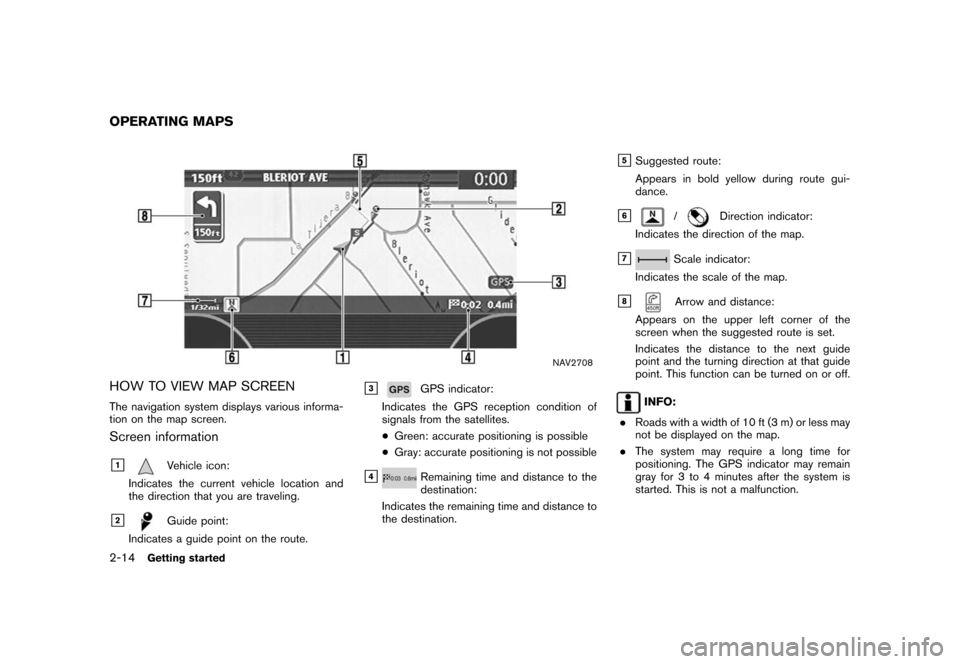
HOW TO VIEW MAP SCREEN
The navigation system displays various informa-
tion on the map screen.
Screen information
&1Vehicle icon:
Indicates the current vehicle location and
the direction that you are traveling.
&2Guide point:
Indicates a guide point on the route.
&3GPS indicator:
Indicates the GPS reception condition of
signals from the satellites.
*Green: accurate positioning is possible
*Gray: accurate positioning is not possible
&4Remaining time and distance to the
destination:
Indicates the remaining time and distance to
the destination.
&5Suggested route:
Appears in bold yellow during route gui-
dance.
&6/Direction indicator:
Indicates the direction of the map.
&7Scale indicator:
Indicates the scale of the map.
&8Arrow and distance:
Appears on the upper left corner of the
screen when the suggested route is set.
Indicates the distance to the next guide
point and the turning direction at that guide
point. This function can be turned on or off.
INFO:
.Roads with a width of 10 ft (3 m) or less may
not be displayed on the map.
.The system may require a long time for
positioning. The GPS indicator may remain
gray for 3 to 4 minutes after the system is
started. This is not a malfunction.
OPERATING MAPS
2-14Getting started
Page 70 of 270
Black plate (70,1)
Model "NISSAN_NAVI" EDITED: 2007/ 2/ 26
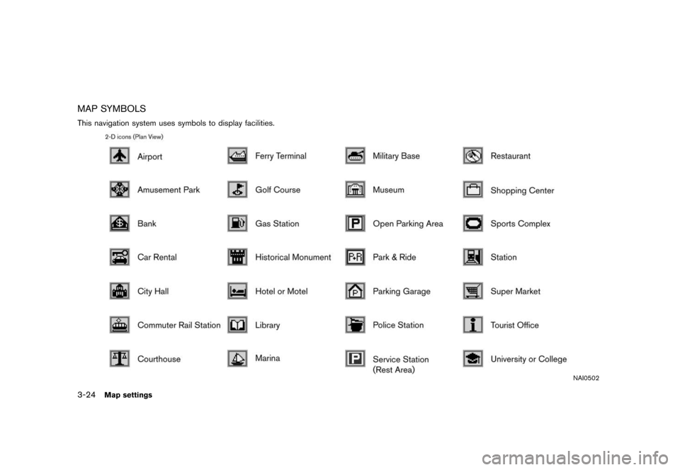
MAP SYMBOLS
This navigation system uses symbols to display facilities.
NAI0502
3-24Map settings
Page 131 of 270
![NISSAN MAXIMA 2008 A34 / 6.G 04IT Navigation Manual Black plate (133,1)
Model "NISSAN_NAVI" EDITED: 2007/ 2/ 26
After setting the route, select [Start] to begin
route guidance.
Throughout route guidance, the system navi-
gates you through the guide poi NISSAN MAXIMA 2008 A34 / 6.G 04IT Navigation Manual Black plate (133,1)
Model "NISSAN_NAVI" EDITED: 2007/ 2/ 26
After setting the route, select [Start] to begin
route guidance.
Throughout route guidance, the system navi-
gates you through the guide poi](/img/5/794/w960_794-130.png)
Black plate (133,1)
Model "NISSAN_NAVI" EDITED: 2007/ 2/ 26
After setting the route, select [Start] to begin
route guidance.
Throughout route guidance, the system navi-
gates you through the guide points using visual
and voice guidance.
CAUTION
The navigation system’s visual and voice
guidance is for reference purposes only.
The contents of the guidance may be
inappropriate depending on the situa-
tion.
When driving along the suggested route,
follow all traffic regulations (e.g., one-
way traffic) .
“ROUTE GUIDANCE” (page 9-11)
VOICE GUIDANCE DURING ROUTE
GUIDANCE
When approaching a guide point (intersection or
corner) , destination, etc. during route guidance,
voice guidance announces the remaining dis-
tance and/or turning direction.
Push
voice guidance.
NAI0418
Example of voice guidance
&1“In about one quarter mile (400 meters) ,
right (left) turn.”
“Right (left) turn ahead.”
&2“In about one quarter mile (400 meters)
freeway entrance on your right onto (road
number and direction) .”
“Freeway entrance on your right onto (road
number and direction) .”
&3“In about one mile (1.6 kilometers) , exit on
your right.”
“Take the second exit on your right.”
&4“You have arrived at your destination. Ending
route guidance.”
ABOUT ROUTE GUIDANCE
Route guidance5-7
Page 167 of 270
Black plate (169,1)
Model "NISSAN_NAVI" EDITED: 2007/ 2/ 26
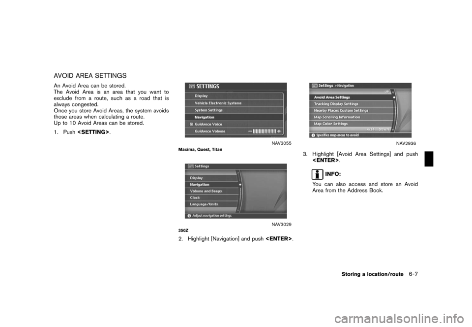
AVOID AREA SETTINGS
An Avoid Area can be stored.
The Avoid Area is an area that you want to
exclude from a route, such as a road that is
always congested.
Once you store Avoid Areas, the system avoids
those areas when calculating a route.
Up to 10 Avoid Areas can be stored.
1. Push
NAV3055Maxima, Quest, Titan
NAV3029350Z
2. Highlight [Navigation] and push
NAV2936
3. Highlight [Avoid Area Settings] and push
INFO:
You can also access and store an Avoid
Area from the Address Book.
Storing a location/route6-7