service NISSAN MAXIMA 2008 A34 / 6.G 06IT Navigation Manual
[x] Cancel search | Manufacturer: NISSAN, Model Year: 2008, Model line: MAXIMA, Model: NISSAN MAXIMA 2008 A34 / 6.GPages: 217, PDF Size: 6.62 MB
Page 4 of 217
Black plate (5,1)
Model "NAV2-N" EDITED: 2007/ 3/ 9
This system is primarily designed to help you
reach your destination, and it also performs
other functions as outlined in this manual.
However, you, the driver, must use the system
safely and properly. Information concerning road
conditions, traffic signs and the availability of
services may not always be up-to-date. The
system is not a substitute for safe, proper and
legal driving.
Before using the navigation system, please read
the following safety information. Always use the
system as outlined in this manual.
WARNING
.When the driver wants to operate
the navigation system or use the
multi-function controller, first park
the vehicle in a safe location and
set the parking brake. Operating
the system while driving can dis-
tract the driver and may result in a
serious accident.
.Do not rely on route guidance
alone. Always be sure that all
driving maneuvers are legal and
safe in order to avoid accidents.
.Do not disassemble or modify thissystem. If you do, it may result in
accidents, fire or electrical shock.
.If you notice any foreign objects in
the system hardware, spill liquid on
the system or notice smoke or a
smell coming from it, stop using the
system immediately and contact a
NISSAN dealer. Ignoring such con-
ditions may lead to accidents, fire
or electrical shock.
CAUTION
.Do not use this system if you notice
any malfunctions such as a frozen
screen or the lack of sound. Con-
tinued use of the system may result
in accidents, fire or electrical shock.
.Some states/provinces may have
laws limiting the use of video
screens while driving. Use this
system only where it is legal to do
so.
.Extreme temperature conditions
[below−48F(−208C) and above
1588F (708C)] could affect the per-
formance of the system.
NOTE:
Do not keep the navigation system running
with the engine stopped. Doing so may
discharge the vehicle battery. When you
use the navigation system, always keep
the engine running.
SAFETY INFORMATION
Introduction1-3
Page 5 of 217
Black plate (6,1)
Model "NAV2-N" EDITED: 2007/ 3/ 9
This navigation system is certified as a Class 1
laser product.
The navigation system complies with DHHS
Rules 21 CFR Chapter 1, Subchapter J.
WARNING
.Do not disassemble or modify this
system. There are no user service-
able parts in this navigation sys-
tem.
.If maintenance, adjustments and
operations other than those speci-
fied in this manual are attempted,
injury due to laser radiation and
exposure could occur.
LASER PRODUCT
1-4Introduction
Page 36 of 217
Black plate (39,1)
Model "NAV2-N" EDITED: 2007/ 3/ 9
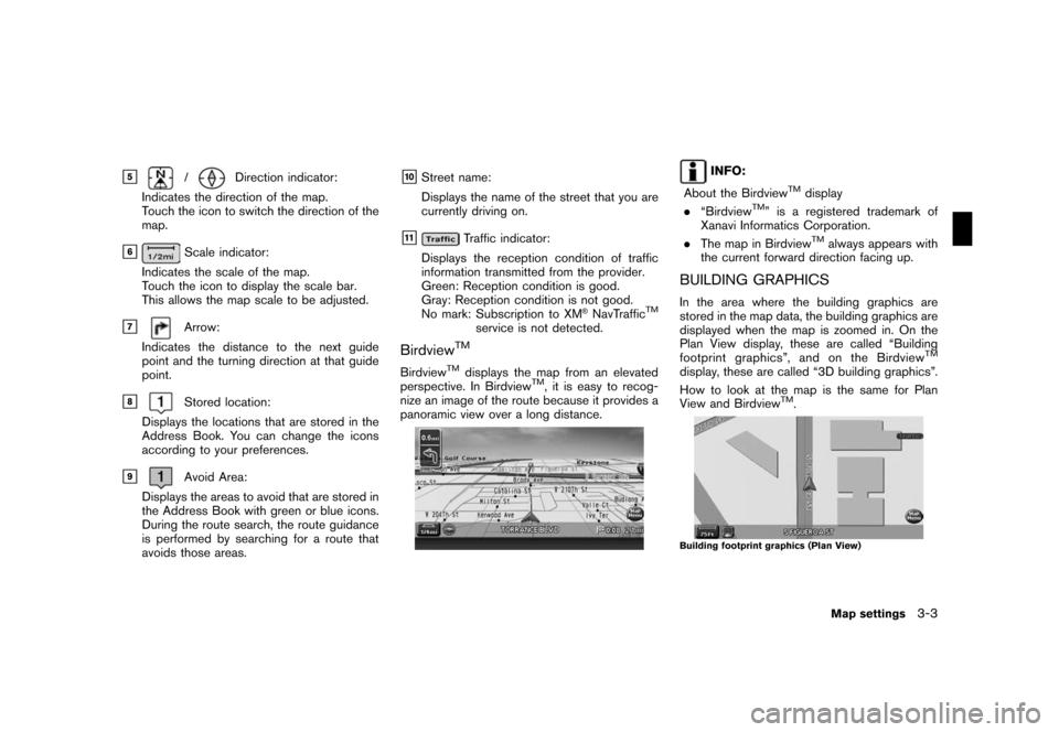
&5/Direction indicator:
Indicates the direction of the map.
Touch the icon to switch the direction of the
map.
&6Scale indicator:
Indicates the scale of the map.
Touch the icon to display the scale bar.
This allows the map scale to be adjusted.
&7Arrow:
Indicates the distance to the next guide
point and the turning direction at that guide
point.
&8Stored location:
Displays the locations that are stored in the
Address Book. You can change the icons
according to your preferences.
&9Avoid Area:
Displays the areas to avoid that are stored in
the Address Book with green or blue icons.
During the route search, the route guidance
is performed by searching for a route that
avoids those areas.
&10Street name:
Displays the name of the street that you are
currently driving on.
&11Traffic indicator:
Displays the reception condition of traffic
information transmitted from the provider.
Green: Reception condition is good.
Gray: Reception condition is not good.
No mark: Subscription to XM
®NavTrafficTM
service is not detected.
BirdviewTM
BirdviewTMdisplays the map from an elevated
perspective. In BirdviewTM, it is easy to recog-
nize an image of the route because it provides a
panoramic view over a long distance.
INFO:
About the Birdview
TMdisplay
.“BirdviewTM” is a registered trademark of
Xanavi Informatics Corporation.
.The map in Birdview
TMalways appears with
the current forward direction facing up.
BUILDING GRAPHICS
In the area where the building graphics are
stored in the map data, the building graphics are
displayed when the map is zoomed in. On the
Plan View display, these are called “Building
footprint graphics”, and on the Birdview
TM
display, these are called “3D building graphics”.
How to look at the map is the same for Plan
View and Birdview
TM.
Building footprint graphics (Plan View)
Map settings3-3
Page 57 of 217
Black plate (60,1)
Model "NAV2-N" EDITED: 2007/ 3/ 9
Road color
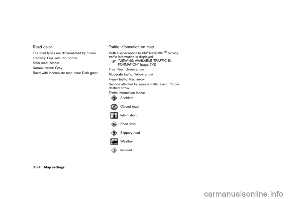
The road types are differentiated by colors.
Freeway: Pink with red border
Main road: Amber
Narrow street: Gray
Road with incomplete map data: Dark green
Traffic information on map
With a subscription to XM®NavTrafficTMservice,
traffic information is displayed.
“VIEWING AVAILABLE TRAFFIC IN-
FORMATION” (page 7-3)
Free Flow: Green arrow
Moderate traffic: Yellow arrow
Heavy traffic: Red arrow
Section affected by serious traffic event: Purple
dashed arrow
Traffic information icons:
Accident
Closed road
Information
Road work
Slippery road
Weather
Incident
3-24Map settings
Page 67 of 217
Black plate (70,1)
Model "NAV2-N" EDITED: 2007/ 3/ 9
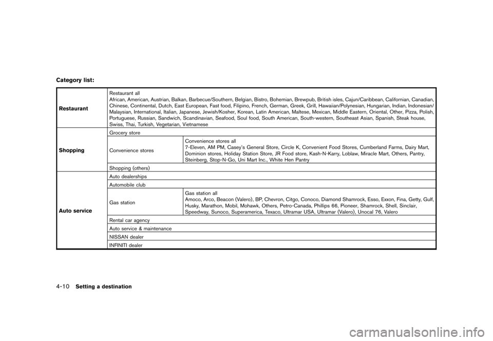
Category list:
Restaurant
Restaurant all
African, American, Austrian, Balkan, Barbecue/Southern, Belgian, Bistro, Bohemian, Brewpub, British isles, Cajun/Caribbean, Californian, Canadian,
Chinese, Continental, Dutch, East European, Fast food, Filipino, French, German, Greek, Grill, Hawaiian/Polynesian, Hungarian, Indian, Indonesian/
Malaysian, International, Italian, Japanese, Jewish/Kosher, Korean, Latin American, Maltese, Mexican, Middle Eastern, Oriental, Other, Pizza,Polish,
Portuguese, Russian, Sandwich, Scandinavian, Seafood, Soul food, South American, South-western, Southeast Asian, Spanish, Steak house,
Swiss, Thai, Turkish, Vegetarian, Vietnamese
Shopping
Grocery store
Convenience storesConvenience stores all
7-Eleven, AM PM, Casey’s General Store, Circle K, Convenient Food Stores, Cumberland Farms, Dairy Mart,
Dominion stores, Holiday Station Store, JR Food store, Kash-N-Karry, Loblaw, Miracle Mart, Others, Pantry,
Steinberg, Stop-N-Go, Uni Mart Inc., White Hen Pantry
Shopping (others)
Auto service
Auto dealerships
Automobile club
Gas stationGas station all
Amoco, Arco, Beacon (Valero) , BP, Chevron, Citgo, Conoco, Diamond Shamrock, Esso, Exxon, Fina, Getty, Gulf,
Husky, Marathon, Mobil, Mohawk, Others, Petro-Canada, Phillips 66, Pioneer, Shamrock, Shell, Sinclair,
Speedway, Sunoco, Superamerica, Texaco, Ultramar USA, Ultramar (Valero) , Unocal 76, Valero
Rental car agency
Auto service & maintenance
NISSAN dealer
INFINITI dealer
4-10Setting a destination
Page 68 of 217
Black plate (71,1)
Model "NAV2-N" EDITED: 2007/ 3/ 9
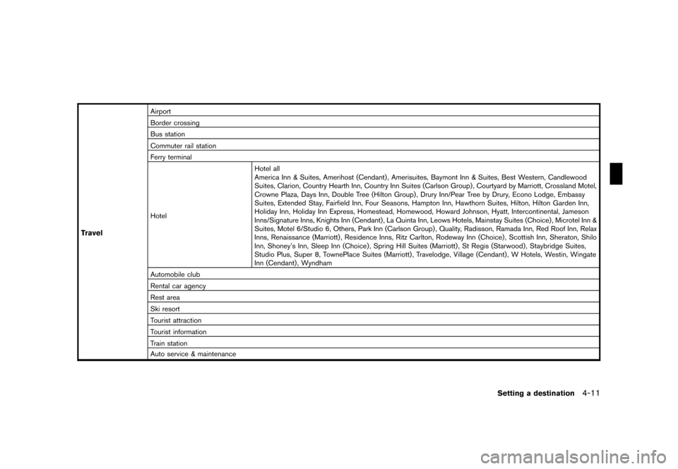
Travel
Airport
Border crossing
Bus station
Commuter rail station
Ferry terminal
HotelHotel all
America Inn & Suites, Amerihost (Cendant) , Amerisuites, Baymont Inn & Suites, Best Western, Candlewood
Suites, Clarion, Country Hearth Inn, Country Inn Suites (Carlson Group) , Courtyard by Marriott, Crossland Motel,
Crowne Plaza, Days Inn, Double Tree (Hilton Group) , Drury Inn/Pear Tree by Drury, Econo Lodge, Embassy
Suites, Extended Stay, Fairfield Inn, Four Seasons, Hampton Inn, Hawthorn Suites, Hilton, Hilton Garden Inn,
Holiday Inn, Holiday Inn Express, Homestead, Homewood, Howard Johnson, Hyatt, Intercontinental, Jameson
Inns/Signature Inns, Knights Inn (Cendant) , La Quinta Inn, Leows Hotels, Mainstay Suites (Choice) , Microtel Inn &
Suites, Motel 6/Studio 6, Others, Park Inn (Carlson Group) , Quality, Radisson, Ramada Inn, Red Roof Inn, Relax
Inns, Renaissance (Marriott) , Residence Inns, Ritz Carlton, Rodeway Inn (Choice) , Scottish Inn, Sheraton, Shilo
Inn, Shoney’s Inn, Sleep Inn (Choice), Spring Hill Suites (Marriott) , St Regis (Starwood), Staybridge Suites,
Studio Plus, Super 8, TownePlace Suites (Marriott) , Travelodge, Village (Cendant) , W Hotels, Westin, Wingate
Inn (Cendant) , Wyndham
Automobile club
Rental car agency
Rest area
Ski resort
Tourist attraction
Tourist information
Train station
Auto service & maintenance
Setting a destination4-11
Page 138 of 217
Black plate (141,1)
Model "NAV2-N" EDITED: 2007/ 3/ 9
XM®NavTrafficTMinformation is a subscription
service offered by XM®Satellite Radio.
This service providesreal-time information
regarding traffic flow, accidents, road construc-
tion and other incidents, where available.
XM
®NavTrafficTMcombines information from
commercial and public traffic data providers
including government departments of transpor-
tation, police, emergency services, road sen-
sors, cameras and aircraft reports. The traffic
information is broadcast to the vehicle by the
XM
®satellites. Available traffic information on
the route the driver selected is shown on the
navigation screen so traffic conditions between
you and the destination are known. Three types
of real-time traffic information for major road-
ways are shown on the navigation system:
* Unscheduled traffic data for example, acci-
dents and disabled vehicles.
* Scheduled traffic data, for example road
construction and road closures.
* Traffic flow information (rate of speed data) .
WARNING
XM®NavTrafficTMinformation is not a
substitute for attentive driving. Traffic
conditions change constantly andemergency situations can arise with-
out warning. Relying only on XM
®
NavTrafficTMinformation may lead to
a collision and could result in serious
personal injury.
NOTE:
Flow information is provided only for
roads equipped with traffic sensors and
is not available in all markets covered by
the service. Flow data may not be available
on portions of a road that is under
construction.
XM
®NavTrafficTMinformation is available in
limited markets. To subscribe or to check if this
service is available in your area:
call 1-800-XM-RADIO (1-800-967-2346) or
see www.xmradio.com/xmnavtraffic/
INFO:
If you do not have a contract for XM
®
NavTrafficTMtraffic information service, a mes-
sage appears, and it will not be possible to
check the information on the traffic information
system.
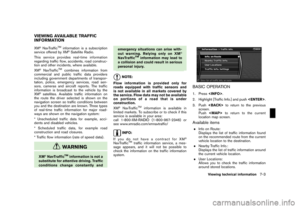
BASIC OPERATION
1. Press
2. Highlight [Traffic Info.] and push
3. Push
screen.
Push
Page 141 of 217
Black plate (144,1)
Model "NAV2-N" EDITED: 2007/ 3/ 9
DISPLAY URGENT TRAFFIC INFOR-
MATION
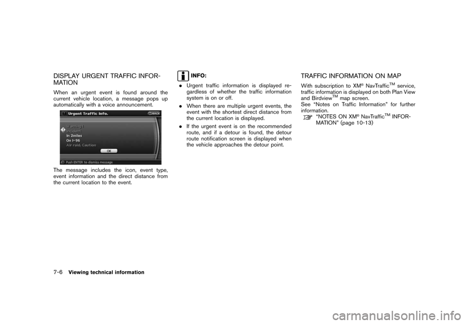
When an urgent event is found around the
current vehicle location, a message pops up
automatically with a voice announcement.
The message includes the icon, event type,
event information and the direct distance from
the current location to the event.
INFO:
.Urgent traffic information is displayed re-
gardless of whether the traffic information
system is on or off.
.When there are multiple urgent events, the
event with the shortest direct distance from
the current location is displayed.
.If the urgent event is on the recommended
route, and if a detour is found, the detour
route notification screen is displayed when
the vehicle approaches the detour point.TRAFFIC INFORMATION ON MAP
With subscription to XM®NavTrafficTMservice,
traffic information is displayed on both Plan View
and Birdview
TMmap screen.
See “Notes on Traffic Information” for further
information.
“NOTES ON XM®NavTrafficTMINFOR-
MATION” (page 10-13)
7-6Viewing technical information
Page 142 of 217
Black plate (145,1)
Model "NAV2-N" EDITED: 2007/ 3/ 9
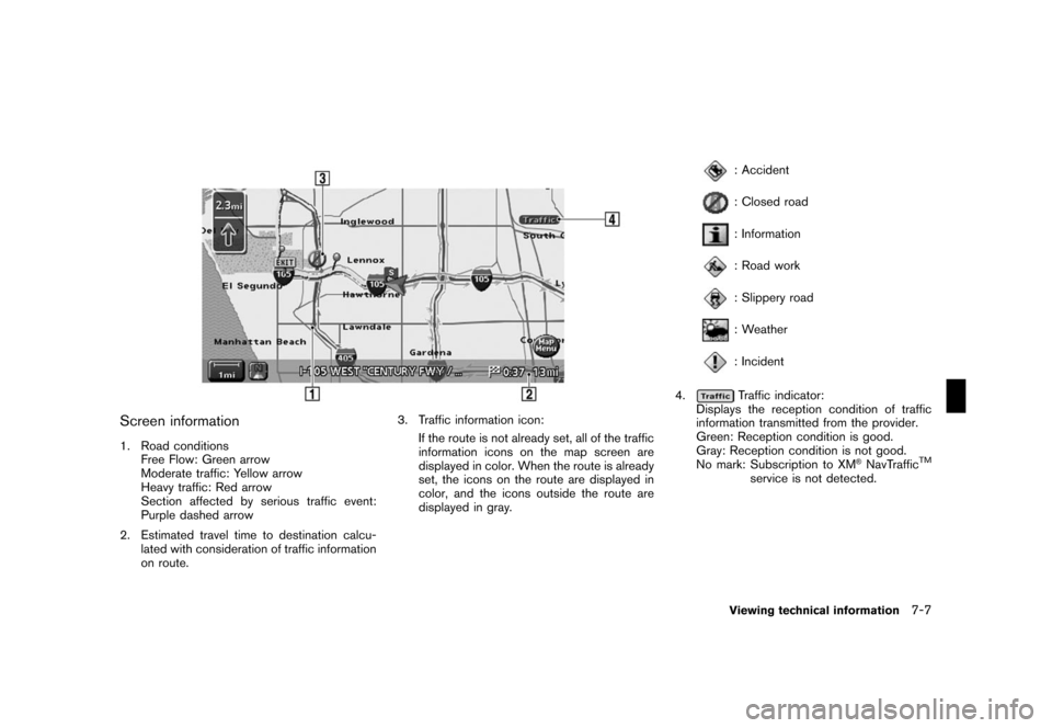
Screen information
1. Road conditions
Free Flow: Green arrow
Moderate traffic: Yellow arrow
Heavy traffic: Red arrow
Section affected by serious traffic event:
Purple dashed arrow
2. Estimated travel time to destination calcu-
lated with consideration of traffic information
on route.3. Traffic information icon:
If the route is not already set, all of the traffic
information icons on the map screen are
displayed in color. When the route is already
set, the icons on the route are displayed in
color, and the icons outside the route are
displayed in gray.
: Accident
: Closed road
: Information
: Road work
: Slippery road
: Weather
: Incident
4.
Traffic indicator:
Displays the reception condition of traffic
information transmitted from the provider.
Green: Reception condition is good.
Gray: Reception condition is not good.
No mark: Subscription to XM
®NavTrafficTM
service is not detected.
Viewing technical information7-7
Page 182 of 217
Black plate (189,1)
Model "NAV2-N" EDITED: 2007/ 3/ 9
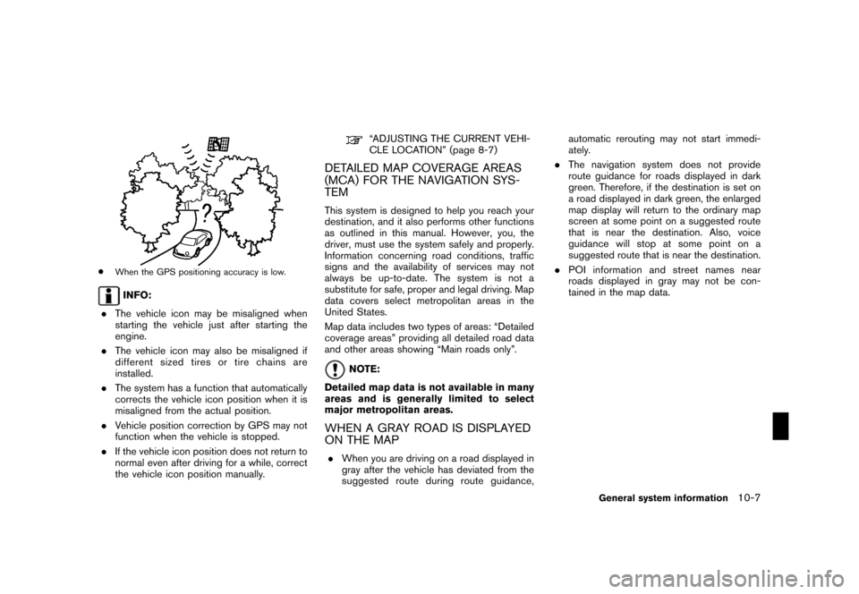
*When the GPS positioning accuracy is low.
INFO:
.The vehicle icon may be misaligned when
starting the vehicle just after starting the
engine.
.The vehicle icon may also be misaligned if
different sized tires or tire chains are
installed.
.The system has a function that automatically
corrects the vehicle icon position when it is
misaligned from the actual position.
.Vehicle position correction by GPS may not
function when the vehicle is stopped.
.If the vehicle icon position does not return to
normal even after driving for a while, correct
the vehicle icon position manually.
“ADJUSTING THE CURRENT VEHI-
CLE LOCATION” (page 8-7)
DETAILED MAP COVERAGE AREAS
(MCA) FOR THE NAVIGATION SYS-
TEM
This system is designed to help you reach your
destination, and it also performs other functions
as outlined in this manual. However, you, the
driver, must use the system safely and properly.
Information concerning road conditions, traffic
signs and the availability of services may not
always be up-to-date. The system is not a
substitute for safe, proper and legal driving. Map
data covers select metropolitan areas in the
United States.
Map data includes two types of areas: “Detailed
coverage areas” providing all detailed road data
and other areas showing “Main roads only”.
NOTE:
Detailed map data is not available in many
areas and is generally limited to select
major metropolitan areas.
WHEN A GRAY ROAD IS DISPLAYED
ON THE MAP
.When you are driving on a road displayed in
gray after the vehicle has deviated from the
suggested route during route guidance,automatic rerouting may not start immedi-
ately.
.The navigation system does not provide
route guidance for roads displayed in dark
green. Therefore, if the destination is set on
a road displayed in dark green, the enlarged
map display will return to the ordinary map
screen at some point on a suggested route
that is near the destination. Also, voice
guidance will stop at some point on a
suggested route that is near the destination.
.POI information and street names near
roads displayed in gray may not be con-
tained in the map data.
General system information10-7