Hose NISSAN PATHFINDER 2005 R51 / 3.G Owners Manual
[x] Cancel search | Manufacturer: NISSAN, Model Year: 2005, Model line: PATHFINDER, Model: NISSAN PATHFINDER 2005 R51 / 3.GPages: 192, PDF Size: 4.45 MB
Page 1 of 192

Thank you for purchasing a NISSAN automobile.
This user’s manual is for the navigation system
only.
This manual contains operating instructions for
the NISSAN navigation system offered in the fol-
lowing models:
cAltima
cArmada
cMaxima
cPathfinder
cQuest
cTitan
Please read this manual carefully to ensure safe
operation of the navigation system. This manual
contains operating instructions for the NISSAN
Navigation System offered in your NISSAN ve-
hicle
cPlease read your vehicle’s owner’s manual
first.
cDo not remove this manual from the vehicle
when selling this vehicle. The next user of this
navigation system may need the manual.
cBecause of possible specification changes,
sections of this manual may not apply to your
vehicle.cAll information, specifications and illustrations
in this manual are those in effect at the time of
printing. NISSAN reserves the right to change
specifications or design at any time without
notice.
FOREWORD
ZREVIEW COPYÐ2005(nav)
Navigation System OMÐUSA_English(nna)
07/10/04Ðdebbie
X
Page 7 of 192

cDo not disassemble or modify this
system. If you do, it may result in
accidents, fire, or electrical shock.
cDo not use this system if you notice
any malfunction such as a frozen
screen or lack of sound. Continued
use of the system may result in
accident, fire, or electrical shock.
cIf you notice any foreign object in the
system hardware or spilled liquid, or
notice smoke or a smell coming from
it, stop using the system immediately
and contact your nearest NISSAN
dealer. Ignoring such conditions may
lead to accidents, fire, or electrical
shock.
NOTE:
Some states/provinces may have laws lim-
iting the use of video screens while
driving. Use this system only where legal.
LASER PRODUCT
This navigation system is certified as a Class 1
laser product.
The navigation system complies with DHHS
Laser-Radiation Standards, 21 CFR Chapter 1,
subchapter J.
WARNING
cDo not disassemble or modify this
system. There are no user service-
able parts in this navigation system.
cIf maintenance, adjustments and op-
erations other than those specified
in this manual are attempted, injury
due to laser radiation and exposure
could occur.
Introduction
1-3
ZREVIEW COPYÐ2005(nav)
Navigation System OMÐUSA_English(nna)
07/10/04Ðdebbie
X
Page 46 of 192

– Even if the freeway preference is set to
OFF, the route may be set on them. To
avoid this, set a waypoint on another
road type and request calculation.
– Even if the preference is set as OFF for a
ferry line, the route may be set on it. To
avoid this, set a waypoint on a road and
request calculation.
– Ferry lines, except those which accept
only pedestrians, bicycles and
motorcycles, are stored in this system.
When using them, take into consider-
ation the travel time required and opera-
tional condition to decide whether to use
them or not.
ABOUT THE DISPLAY ERROR
The following cases may affect the display accu-
racy of the vehicle’s position or travel direction.
The accuracy will return to normal if the driving
conditions return to normal:
– When there is a similar road nearby.
– When the vehicle is traveling on a long stretch
of straight road or series of curves with a large
radius.
– When the vehicle is traveling in an area with a
checkerboard road system.– When the vehicle is making consecutive S
curves.
– When the vehicle is at a large Y-shaped
junction.
– When the vehicle is on a loop bridge.
– When the vehicle is on a snow-covered or un-
paved road.
– When the vehicle has made several consecu-
tive turns or zigzags.
– When the vehicle is rotated on a parking lot
turntable while the ignition switch is OFF.
– Immediately after the vehicle is driven out of a
parking garage or underground parking lot.
– When the vehicle has different sizes of tires or
tire chains.
– When the vehicle is moved immediately after
the engine is started.
4-28How do I operate the Nissan navigation system?
ZREVIEW COPYÐ2005(nav)
Navigation System OMÐUSA_English(nna)
07/10/04Ðdebbie
X
Page 51 of 192

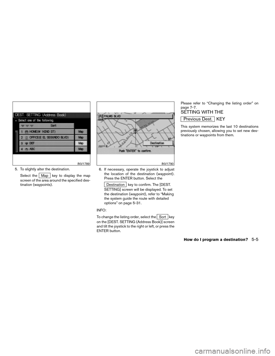
5. To slightly alter the destination.
Select the
Map key to display the map
screen of the area around the specified des-
tination (waypoints) .6. If necessary, operate the joystick to adjust
the location of the destination (waypoint) .
Press the ENTER button. Select the
Destination key to confirm. The [DEST.
SETTING] screen will be displayed. To set
the destination (waypoint) , refer to “Making
the system guide the route with detailed
options” on page 5-31.
INFO:
To change the listing order, select the
Sort key
on the [DEST. SETTING (Address Book)] screen
and tilt the joystick to the right or left, or press the
ENTER button.Please refer to “Changing the listing order” on
page 7-7.
SETTING WITH THE
Previous Dest. KEY
This system memorizes the last 10 destinations
previously chosen, allowing you to set new des-
tinations or waypoints from them.
INV1789INV1790
How do I program a destination?5-5
ZREVIEW COPYÐ2005(nav)
Navigation System OMÐUSA_English(nna)
07/10/04Ðdebbie
X
Page 91 of 192

This key is used to find the name of the street on
which the vehicle is currently located.
1. Press the ROUTE button.
Several keys appear on the right of the screen.
Select the
Where am I? key.2. The display shows the [WHERE AM I ?]
screen, which includes the next, current,
and previous streets. Each one shows the
streets which the vehicle is approaching,
currently traveling on, and those streets the
vehicle was previously traveling on. Press
the MAP or PREV button to return to
the map.1. Press the ROUTE button.
2. Several keys appear on the right of the
screen. Select the
Cancel Guidance key.
INV1887INV1888INV1889
WHERE AM I?CANCEL GUIDANCE
How do I program a destination?5-45
ZREVIEW COPYÐ2005(nav)
Navigation System OMÐUSA_English(nna)
07/10/04Ðdebbie
X
Page 152 of 192

cWhen the system is re-drawing the display in
Birdview™ display, the distance the vehicle
travels becomes longer, and/or the degree
the vehicle turns becomes larger than in the
Planview display in order to complete
re-drawing.
cThe names of the roads and locations may
differ, depending on where the names appear
on the screen.
cIn order to avoid having too much detail on the
map, all road names are not always shown on
the screen. When the display re-draws the
map, a road name which is shown on the pre-
vious screen may not appear on the new
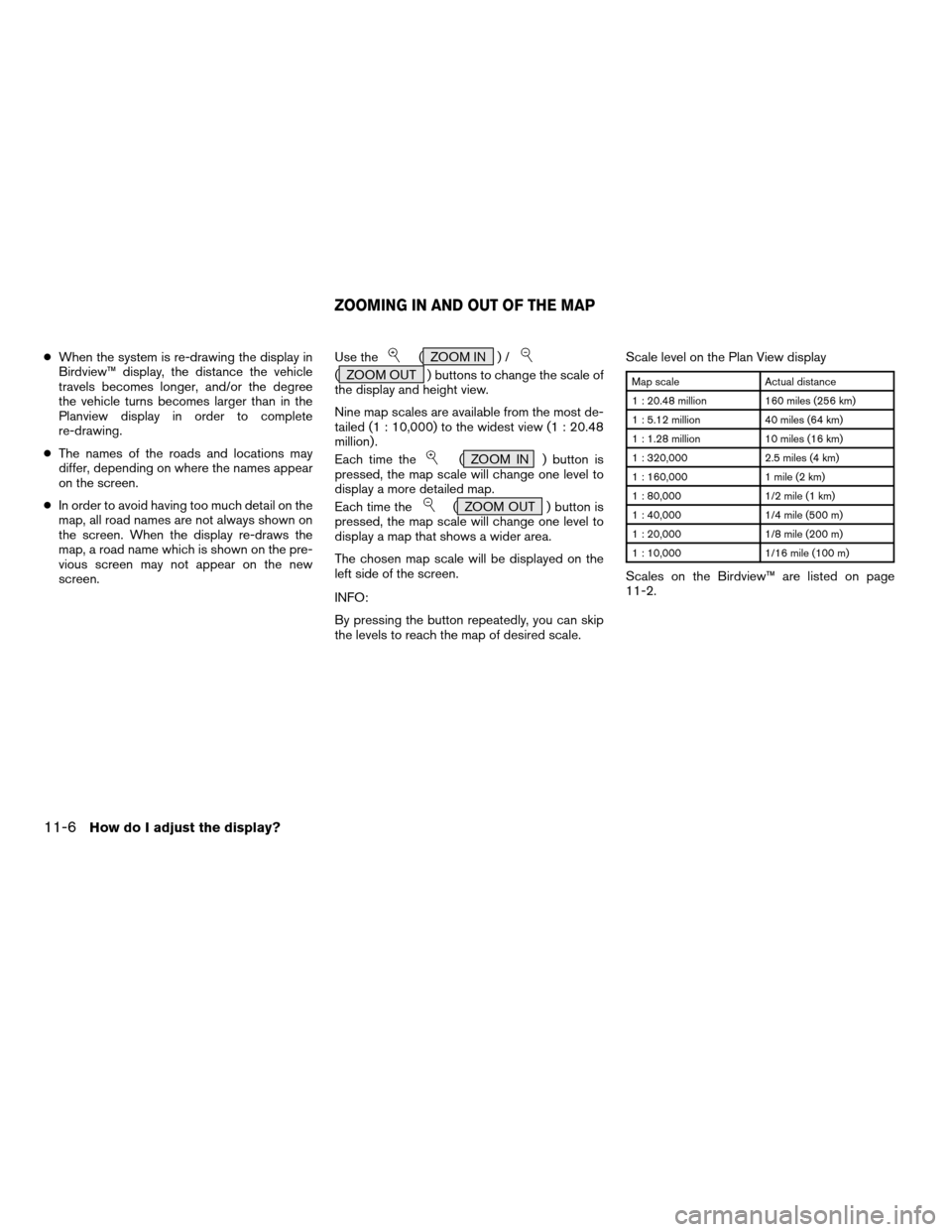
screen.Use the( ZOOM IN ) /
( ZOOM OUT ) buttons to change the scale of
the display and height view.
Nine map scales are available from the most de-
tailed (1 : 10,000) to the widest view (1 : 20.48
million) .
Each time the
( ZOOM IN ) button is
pressed, the map scale will change one level to
display a more detailed map.
Each time the
( ZOOM OUT ) button is
pressed, the map scale will change one level to
display a map that shows a wider area.
The chosen map scale will be displayed on the
left side of the screen.
INFO:
By pressing the button repeatedly, you can skip
the levels to reach the map of desired scale.Scale level on the Plan View display
Map scale Actual distance
1 : 20.48 million 160 miles (256 km)
1 : 5.12 million 40 miles (64 km)
1 : 1.28 million 10 miles (16 km)
1 : 320,000 2.5 miles (4 km)
1 : 160,000 1 mile (2 km)
1 : 80,000 1/2 mile (1 km)
1 : 40,000 1/4 mile (500 m)
1 : 20,000 1/8 mile (200 m)
1 : 10,000 1/16 mile (100 m)
Scales on the Birdview™ are listed on page
11-2.
ZOOMING IN AND OUT OF THE MAP
11-6How do I adjust the display?
ZREVIEW COPYÐ2005(nav)
Navigation System OMÐUSA_English(nna)
07/10/04Ðdebbie
X
Page 173 of 192

ABOUT THE NAVIGATION MAP
DVD-ROM
1. This navigation map DVD-ROM has been
prepared by ZENRIN CO., LTD. under li-
cense from Navigation Technologies
Corporation. ZENRIN CO., LTD. has added,
processed and digitized data based on the
digital road map data of Navigation Tech-
nologies Corporation. Due to the produc-
tion timing of the map data, some new roads
may not be included in this map data or
some of the names or roads may be differ-
ent from those at the time you use this
DVD-ROM.
2. Traffic control and regulation data used in
this DVD-ROM may be different from those
at the time you use this DVD-ROM due to
the data production timing. When driving
your vehicle, follow the actual traffic control
signs and notices on the roads.
3. Reproducing or copying this map software
is strictly prohibited by law.
Published by NISSAN North America, Inc.
© 2002 Navigation Technologies. All rights
reserved. “Certain business data provided by
infoUSA.com, Inc. Copyright 2002, All rights
reserved”.
ICONS
Icon legend follows:
Information on map data discs12-3
ZREVIEW COPYÐ2005(nav)
Navigation System OMÐUSA_English(nna)
07/10/04Ðdebbie
X
Page 179 of 192

13 Troubleshooting guide
Customer assistance.............................13-2
Basic operations.................................13-3
Vehicle icon......................................13-4
Map DVD-ROM..................................13-6Destination, waypoints or menu contents cannot be
chosen or set....................................13-7
Voice guidance...................................13-8
Route calculation.................................13-9
ZREVIEW COPYÐ2005(nav)
Navigation System OMÐUSA_English(nna)
07/10/04Ðdebbie
X
Page 185 of 192

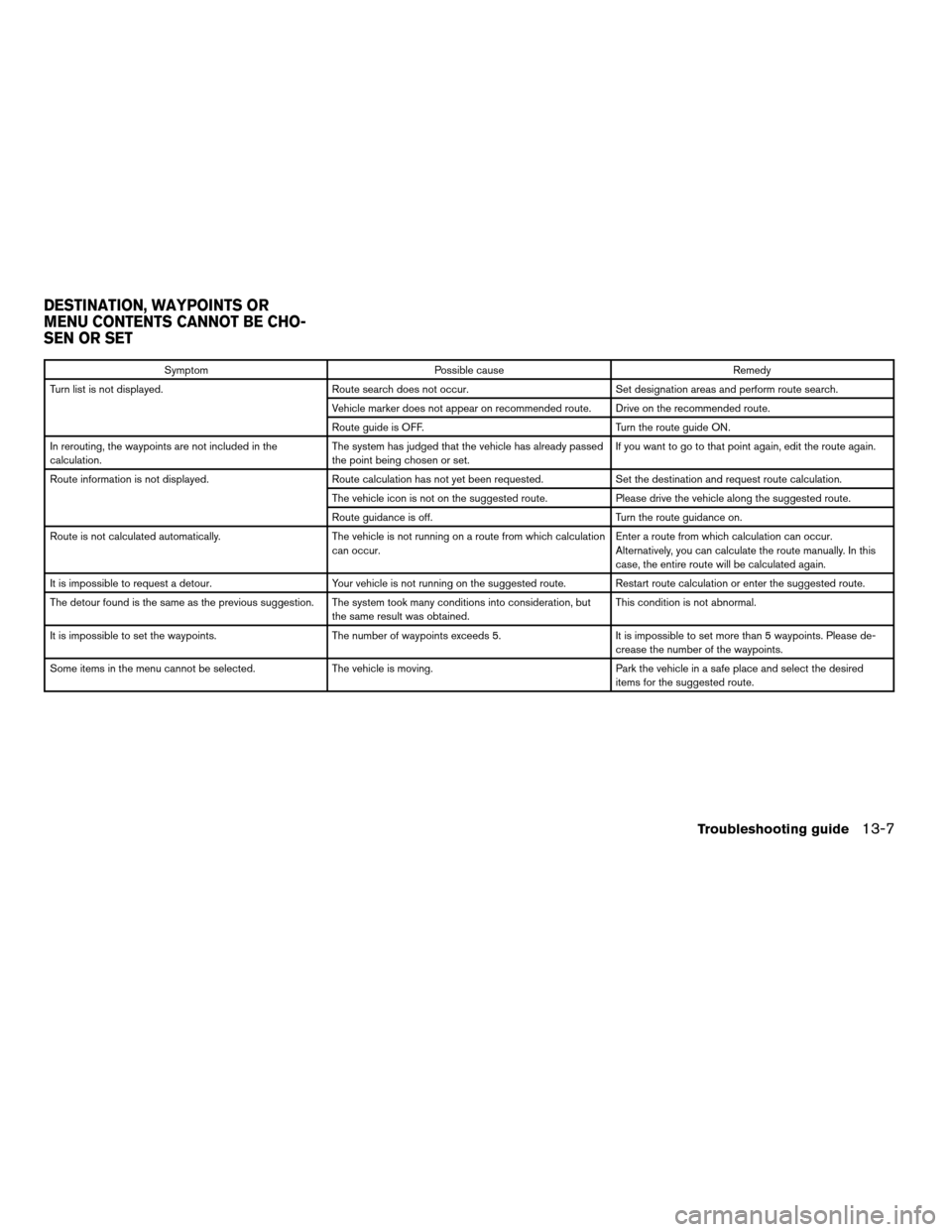
Symptom Possible cause Remedy
Turn list is not displayed. Route search does not occur. Set designation areas and perform route search.
Vehicle marker does not appear on recommended route. Drive on the recommended route.
Route guide is OFF. Turn the route guide ON.
In rerouting, the waypoints are not included in the
calculation.The system has judged that the vehicle has already passed
the point being chosen or set.If you want to go to that point again, edit the route again.
Route information is not displayed. Route calculation has not yet been requested. Set the destination and request route calculation.
The vehicle icon is not on the suggested route. Please drive the vehicle along the suggested route.
Route guidance is off. Turn the route guidance on.
Route is not calculated automatically. The vehicle is not running on a route from which calculation
can occur.Enter a route from which calculation can occur.
Alternatively, you can calculate the route manually. In this
case, the entire route will be calculated again.
It is impossible to request a detour. Your vehicle is not running on the suggested route. Restart route calculation or enter the suggested route.
The detour found is the same as the previous suggestion. The system took many conditions into consideration, but
the same result was obtained.This condition is not abnormal.
It is impossible to set the waypoints. The number of waypoints exceeds 5. It is impossible to set more than 5 waypoints. Please de-
crease the number of the waypoints.
Some items in the menu cannot be selected. The vehicle is moving. Park the vehicle in a safe place and select the desired
items for the suggested route.
DESTINATION, WAYPOINTS OR
MENU CONTENTS CANNOT BE CHO-
SEN OR SET
Troubleshooting guide13-7
ZREVIEW COPYÐ2005(nav)
Navigation System OMÐUSA_English(nna)
07/10/04Ðdebbie
X