display NISSAN TITAN 2017 1.G LC2F Kai Navigation Manual
[x] Cancel search | Manufacturer: NISSAN, Model Year: 2017, Model line: TITAN, Model: NISSAN TITAN 2017 1.GPages: 88, PDF Size: 0.84 MB
Page 65 of 88
This system is primarily designed to help you
reach your destination, and it performs other
functions as outlined in this manual. However the
driver must use the system safely and properly.
Information concerning road conditions, traffic
signs and the availability of services may not al-
ways be up-to-date. The system is not a substi-
tute for safe, proper and legal driving.
Before using the navigation system, please read
the following safety information. Always use the
system as outlined in this manual.
mWARNING
●When the driver wants to operate the
navigation system, first park the ve-
hicle in a safe location and set the
parking brake. Operating the system
while driving can distract the driver
and may result in a serious accident.
● Do not rely on route guidance alone.
Always be sure that all driving ma-
neuvers are legal and safe in order to
avoid accidents.
● Do not disassemble or modify this
system. If you do, it may result in
accidents, fire or electrical shock. ●
Do not use this system if you notice
any malfunctions such as a frozen
screen or lack of sound. Continued
use of the system may result in
accidents, fire or electrical shock.
● If you notice any foreign objects in
the system hardware, spill liquid on
the system or notice smoke or a
smell, stop using the system immedi-
ately and contact a NISSAN dealer.
Ignoring such conditions may lead to
accidents, fire or electrical shock.CAUTION
●Some states or provinces may have
laws limiting the use of video
screens while driving. Use this sys-
tem only where it is legal to do so.
NOTE:
Do not keep the navigation system running
with the engine stopped. Doing so may
discharge the vehicle battery. When you
use the navigation system, always keep
the engine running.
ROUTE GUIDANCE
The main features of the NISSAN Navigation
System are visual guidance and voice guidance
in selected map coverage areas. Utilizing a net-
work of GPS (Global Positioning System)
satellites, the NISSAN Navigation System tracks
the location on the map and navigates to a pre-
ferred location.
Once you set the destination in a map coverage
area, the NISSAN Navigation System will calcu-
late a route from your current location to your
destination. The real-time map display and turn-
by-turn voice guidance leads the driver along the
route. These features can be especially helpful
when driving to unfamiliar locations.
The system may be unable to set a destination
and/or calculate a route when the destination is
outside the map coverage area. Additionally,
voice guidance may not be available if the desti-
nation is outside the map coverage area. For
more information on how to set a destination, re-
fer to Section 4.
SAFETY INFORMATION FEATURES OF THIS NAVIGATION
SYSTEM
6-2General system information
Page 66 of 88
POINTS OF INTEREST DIRECTORY
The NISSAN Navigation System offers an exten-
sive Points of Interest directory in map coverage
areas. This directory includes a wide variety of
destinations. By accessing the Points of Interest
directory, you can search for addresses for a
destination, and just by pushing a button, the
NISSAN Navigation System will calculate a
route to the destination.
The Points of Interest directory has many uses.
For example, the directory can be sorted by the
various types of restaurants near your current
location. If you need a bank or a gas station, the
NISSAN Navigation System can navigate you to
the closest preferred location using the Points of
Interest entered in the system.
“SETTING A DESTINATION FROM
POINTS OF INTEREST” (page 4-9)
ADDRESS BOOK
The address book can store up to 50 locations
from map coverage areas into a personal
directory. This is especially useful for frequently
visited locations, such as clients, relatives and
friends. The address book function allows easy
access to frequently visited locations when set-
ting them as your destination.
“SETTING A DESTINATION FROM
THE ADDRESS BOOK” (page 4-17)
SIRIUSXM TRAFFIC INFORMATION
When available, the SiriusXM Traffic Information
broadcast may help to avoid delays due to traffic
incidents. Traffic jams, roadwork, closed roads
around the current location, etc. are represented
graphically on the map by icons depicting the
nature of the event. Incidents on the route are
automatically displayed when they are
approached.
The SiriusXM Traffic Information feature, via the
guidance mode, may help to detour around traf-
fic problems. For more information on the
SiriusXM Traffic Information feature, refer to
section 4.
VOICE GUIDANCE
Route guidance is provided through voice and
visual instructions. Voice guidance announces
the appropriate directions when approaching an
intersection at which you need to turn. To repeat
the voice guidance, touch the “Voice” key.
The voice guidance can be alternately enabled
or disabled by touching and holding the “Voice”
key on the screen for about two seconds. When
the voice guidance is disabled, the “Voice” key
on the screen will appear grayed out.
LNV2026
General system information6-3
Page 73 of 88
GoogleTMSend-To-Car
Use your favorite connected device to send an
address to your NissanConnectSMsystem via
the Send-To-Car website. When you start your
vehicle, select the ’Sent To Car’ button. The ad-
dress will be delivered and loaded into the
system. Obtain the specific address for your ve-
hicle by registering here:
For U.S. customers
www.nissanusa.com/connect
For Canadian customers
www.nissan.ca/nissanconnect (English)
www.nissan.ca/nissanconnect/fr (French)
Destination Send-To-Car
Use the NissanConnectSMwebsite to search
and send destinations directly to your vehicle.
Obtain the specific address for your vehicle by
registering here:
For U.S. customers
www.nissanusa.com/connect
For Canadian customers
www.nissan.ca/nissanconnect (English)
www.nissan.ca/nissanconnect/fr (French)
Journey Planner
Before you travel, use the NissanConnectSM
Services Web Portal to help you plan your itiner- ary and simplify your trip. Just enter your starting
point and end destination plus locations you’d
like to stop at along the way. Journey Planner will
determine your route, calculate driving distance
and time, and send your journey plan to your
vehicle. Learn more about this feature here:
For U.S. customers
www.nissanusa.com/connect
For Canadian customers
www.nissan.ca/nissanconnect (English)
www.nissan.ca/nissanconnect/fr (French)
Connected Search
Use GoogleTMto search for a destination with-
out knowing the specific name or category. Sim-
ply type in the name of a destination and a list of
options will be presented. Choose an item from
the list to view details such as its address and
phone number. Options to save the item, plot the
navigation or calling the location are also
available.
Message History
This option displays in-vehicle messaging notify-
ing customers about scheduled maintenance
appointments and important information about
their vehicle like warranty alerts. Vehicle owners
can also opt-in to receive promotional offers in
their vehicle.
EMERGENCY SUPPORT INFORMA-
TION (if so equipped)
NissanConnectSMServices provides various
services to support dealing with emergencies of
the subscribed vehicle and the driver.
For example, in case of an illness or serious
injury, you can seek support by pressing the in-
vehicle SOS button and connecting to Nissan-
Connect
SMServices. NissanConnectSMSer-
vices can specify the location of the vehicle via
GPS, and the information will be sent to the po-
lice or other agencies as needed.
For information about other NissanConnect
SM
Services emergency support related services,
refer to the NissanConnectSMServices website
or contact the NissanConnectSMServices sup-
port line.
NissanConnect
SMServices website:
For U.S. customers
www.nissanusa.com/connect
For Canadian customers
www.nissan.ca/nissanconnect (English)
www.nissan.ca/nissanconnect/fr (French)
NissanConnect
SMServices support line:
1-855-426-6628
6-10General system information
Page 75 of 88
DISPLAY OF CURRENT VEHICLE
LOCATION
This navigation system combines the data ob-
tained from the vehicle (by gyro sensor) and from
GPS (Global Positioning System) satellites to
calculate the current location of the vehicle. This
position is then displayed throughout route guid-
ance to a destination.
WHAT IS GPS (Global Positioning
System)?
GPS is a position detecting system that uses
satellites deployed by the U.S. government. This
navigation system receives radio signals from
three or more different satellites that orbit
13,049 miles (21,000 km) above the earth in
space, and detects the position of the vehicle by
utilizing the principle of triangulation.
DETAILED MAP COVERAGE (MCA)
FOR THE NAVIGATION SYSTEM
This system is designed to help you reach your
destination, and also performs other functions as
outlined in this manual. However, you, the driver,
must use the system safely and properly. Infor-
mation concerning road conditions, traffic signs
and the availability of services may not always be
up-to-date. The system is not a substitute for
safe, proper, and legal driving.Map data is available on the provided SD-card.
For information about the map SD-card, contact
a NISSAN dealer or call the NISSAN NAVIGA-
TION SYSTEM HELPDESK. See the contact in-
formation on the inside front cover of this
manual.
Map data includes 2 types of areas: “Detailed
coverage areas” providing all detailed road data
and other areas showing “Main roads only”.
NOTE:
Detailed map data is not available in many
areas and is generally limited to select ma-
jor metropolitan areas.
WHEN A GRAY ROAD IS DIS-
PLAYED ON THE MAP
● Route calculation may not be possible when a
destination or the current vehicle location is
near a gray road.
● Route guidance (enlarged view and voice
guidance) may not be available at the inter-
section where the road your vehicle is driving
on and a gray road intersect.
● Places information and street names near
gray roads are not contained in the map data. ●
The NISSAN Navigation System may not cal-
culate a route if the current vehicle location is
too far away from the destination. In this case,
please divide your trip by selecting one or two
intermediate destinations.
● To reach your destination, refer to the map
screen. Always follow actual roads and regu-
lations and drive safely.
● The suggested route may not be the shortest,
nor are other circumstances such as traffic
jams considered unless the SiriusXM Traffic is
active.
● Because of the inevitable difference in road
conditions and circumstances between the
time you use this system and the time the in-
formation was produced for the map data,
there may be discrepancies in roads and
regulations. In such cases, follow the actual
information available.
● During route calculation, the map will not
scroll, however the vehicle icon will move with
the actual vehicle’s movement.
● In some cases, after the calculation is
complete, the calculated route may not be im-
mediately displayed.
● If you scroll the map while the suggested
route is being drawn, it may take more time to
finish drawing.
CURRENT VEHICLE LOCATION ROUTE CALCULATION
6-12General system information
Page 76 of 88
●If waypoints are set, the system calculates
multiple routes between waypoints
simultaneously, and the following may result.
– If one section between waypoints cannot be calculated, none of the route will be
displayed.
– The route may not connect completely at some waypoints.
– The route may require a U-turn close to some waypoints.
● Route calculation may not be completed in
the following cases.
– If there is no main road within a range of 1.5 miles (2.5 km) from the vehicle, a
message will then appear on the screen.
Try recalculating when the vehicle is
closer to a main road.
– If the vehicle is too close to the destina- tion or if there are no roads to the
destination, a message will then appear
on the screen.
– If it is impossible to reach the destination or waypoints because of traffic
regulations, etc.
– If the only target route to the destination or waypoints is extremely complicated. ●
The following may occur when the route is
displayed.
– If you calculate a route on a main road, the starting point of the route may not ex-
actly match the current vehicle location.
– The endpoint of the route may not exactly match the destination.
– If you calculate a route on a main road, the system may display a route from an-
other main road. This may be because
the position of the vehicle icon is not
accurate. In this case, park the vehicle in
a safe location and reset the vehicle icon,
or continue driving to see if the position
of the vehicle icon is automatically ad-
justed before recalculating the route.
“VEHICLE ICON” (page 7-3)
– In some cases, the system shows an in- direct route to the destination or way-
points if you set them from stored or
places information. In order to correct,
you must be careful about the traffic
direction, especially when lanes with dif-
ferent travel directions are shown
separately, such as interchanges and
service areas. – Even if the freeway preference is set to
OFF, a route that uses the freeway may
be suggested.
– Even if the preference is set to OFF, a route that uses a ferry line may be
suggested.
– Ferry lines, excluding those that are only for pedestrians, bicycles and
motorcycles, are stored in this system.
Take into consideration the travel time re-
quired and operational condition before
deciding whether to use the route.
General system information6-13
Page 78 of 88
●When the vehicle has deviated from the sug-
gested route, voice guidance is not available.
The system will not announce this to you. Re-
fer to the map and recalculate the route.
● Voice guidance may not accurately corre-
spond with road numbers and directions at
freeway junctions.
● Voice guidance may not accurately corre-
spond to street names at freeway exits.
● The displayed street names may sometimes
differ from the actual names, or “UNKNOWN
STREET NAME” may be displayed.
● Voice guidance is not available when the fea-
ture is disabled in the SETTINGS menu.
● Voice guidance will start when the vehicle en-
ters the suggested route. Refer to the map for
directions to the starting point of the route.
● When approaching a waypoint, voice guid-
ance will announce, “You have reached your
intermediate destination on the (left/right)
side.” Voice guidance will switch to the next
section of the route. When voice guidance is
not available, refer to the map for directions.
● In some cases, voice guidance ends before
arrival at the destination. Refer to the destina-
tion icon on the map to reach the destination. ●
If the system recognizes on which side the
destination (waypoint) is located, voice guid-
ance will announce “on the right/left” after an-
nouncing the arrival at the destination.
● Voice guidance may be partially operational or
inoperative due to the angle of roads at an
intersection.
● Because it is not possible to consider data
concerning roads that are seasonally available
or unavailable, a route may be displayed that
does not match the actual traffic restrictions.
Be sure to follow the actual traffic restrictions
while driving.
● Canada and Alaska contain many roads with
incomplete map data. As a result, when
searching for a route, the route may include
roads with incomplete data. In regions where
road data is not complete, voice guidance
may stop for long periods of time. Be sure to
follow the actual traffic restrictions while
driving. The display is a liquid crystal display and should
be handled with care.
mWARNING
Never disassemble the display. Some
parts utilize extremely high voltage.
Touching them may result in serious
personal injury.
CHARACTERISTICS OF A LIQUID
CRYSTAL DISPLAY
●
If the temperature inside the vehicle is espe-
cially low, the display will stay relatively dim or
the movement of the images may be slow.
These conditions are normal. The display will
function normally when the interior of the ve-
hicle has warmed up.
● Some pixels in the display are darker or
brighter than others. This condition is an in-
herent characteristic of liquid crystal displays,
and it is not a malfunction.
● A remnant of the previous display image may
remain on the screen. This screen burn is in-
herent in displays, and it is not a malfunction.
INFO:
The screen may become distorted by strong
magnetic fields.
HOW TO HANDLE THE DISPLAY
General system information6-15
Page 79 of 88
MAINTENANCE OF THE DISPLAY
CAUTION
●To clean the display, never use a
rough cloth, alcohol, benzine,
thinner, any kind of solvent, or paper
tissues with chemical cleaning agent.
They would scratch or deteriorate the
panel.
● Do not splash any liquid such as wa-
ter or car fragrance on the display.
Contact with liquid will cause the
system to malfunction and damage
the hardware.
For cleaning, use a dry soft cloth. If additional
cleaning is necessary, use a small amount of
neutral detergent with a soft cloth. Never spray
the screen with water or detergent. Dampen the
cloth first, then wipe the screen.
6-16General system information
Page 81 of 88
SymptomPossible cause Possible solution
No image is displayed. The brightness is at the lowest setting. Adjust the brightness of the display.
The display is turned off. Press the
button to turn on the display.
The system is in overheat mode due to excessive
high temperature. Wait until the system cools down.
No voice guidance is available.
or
The volume is too high or too low. The volume is not set correctly, or it is turned off. Adjust the volume of voice guidance or turn voice guidance on.
No map is displayed on the screen. The map SD-card is not inserted. Insert the map SD-card correctly.
A screen other than map screen is displayed. Press MAP.
The screen is too dim. The movement is slow. The temperature in the interior of the vehicle is low. Wait until the interior of the vehicle has warmed up.
Some pixels in the display are darker or
brighter than others. This condition is an inherent characteristic of liquid
crystal displays. This is not a malfunction.
Some menu items cannot be selected. Some menu items become unavailable while the vehicle is driven. Park the vehicle in a safe location, and then operate the navigation system.
NOTE:
Locations stored in the Address Book and other memory functions may be lost if the vehicle’s battery is disconnected or is discharged.
If this occurs, service the vehicle’s battery as necessary and re-enter the information in the Address Book.
BASIC OPERATIONS
7-2Troubleshooting guide
Page 82 of 88
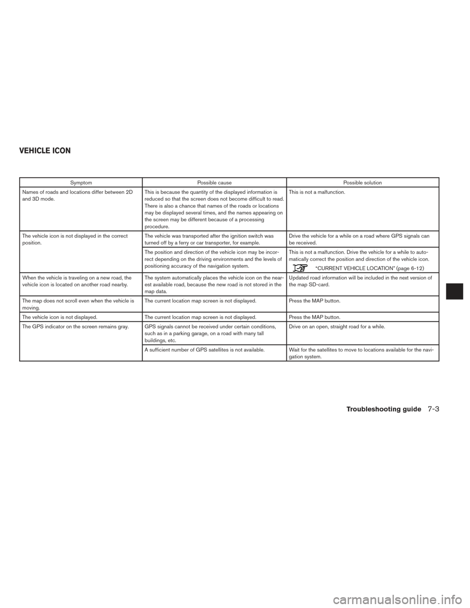
SymptomPossible cause Possible solution
Names of roads and locations differ between 2D
and 3D mode. This is because the quantity of the displayed information is
reduced so that the screen does not become difficult to read.
There is also a chance that names of the roads or locations
may be displayed several times, and the names appearing on
the screen may be different because of a processing
procedure. This is not a malfunction.
The vehicle icon is not displayed in the correct
position. The vehicle was transported after the ignition switch was
turned off by a ferry or car transporter, for example. Drive the vehicle for a while on a road where GPS signals can
be received.
The position and direction of the vehicle icon may be incor-
rect depending on the driving environments and the levels of
positioning accuracy of the navigation system. This is not a malfunction. Drive the vehicle for a while to auto-
matically correct the position and direction of the vehicle icon.
“CURRENT VEHICLE LOCATION” (page 6-12)
When the vehicle is traveling on a new road, the
vehicle icon is located on another road nearby. The system automatically places the vehicle icon on the near-
est available road, because the new road is not stored in the
map data. Updated road information will be included in the next version of
the map SD-card.
The map does not scroll even when the vehicle is
moving. The current location map screen is not displayed.
Press the MAP button.
The vehicle icon is not displayed. The current location map screen is not displayed. Press the MAP button.
The GPS indicator on the screen remains gray. GPS signals cannot be received under certain conditions, such as in a parking garage, on a road with many tall
buildings, etc. Drive on an open, straight road for a while.
A sufficient number of GPS satellites is not available. Wait for the satellites to move to locations available for the navi- gation system.
VEHICLE ICON
Troubleshooting guide7-3
Page 84 of 88
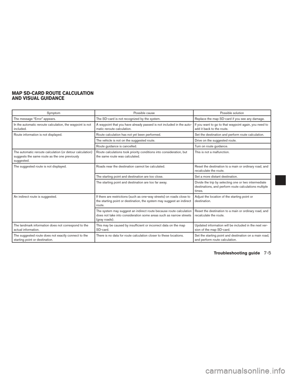
SymptomPossible cause Possible solution
The message “Error” appears. The SD-card is not recognized by the system. Replace the map SD-card if you see any damage.
In the automatic reroute calculation, the waypoint is not
included. A waypoint that you have already passed is not included in the auto-
matic reroute calculation. If you want to go to that waypoint again, you need to
add it back to the route.
Route information is not displayed. Route calculation has not yet been performed. Set the destination and perform route calculation.
The vehicle is not on the suggested route. Drive on the suggested route.
Route guidance is cancelled. Turn on route guidance.
The automatic reroute calculation (or detour calculation)
suggests the same route as the one previously
suggested. Route calculations took priority conditions into consideration, but
the same route was calculated.
This is not a malfunction.
The suggested route is not displayed. Roads near the destination cannot be calculated. Reset the destination to a main or ordinary road, and
recalculate the route.
The starting point and destination are too close. Set a more distant destination.
The starting point and destination are too far away. Divide the trip by selecting one or two intermediate
destinations, and perform route calculations multiple
times.
An indirect route is suggested. If there are restrictions (such as one-way streets) on roads close to
the starting point or destination, the system may suggest an indirect
route. Adjust the location of the starting point or
destination.
The system may suggest an indirect route because route calculation
does not take into consideration some areas such as narrow streets
(gray roads) . Reset the destination to a main or ordinary road, and
recalculate the route.
The landmark information does not correspond to the
actual information. This may be caused by insufficient or incorrect data on the map
SD-card. Updated information will be included in the next ver-
sion of the map SD-card.
The suggested route does not exactly connect to the
starting point or destination. There is no data for route calculation closer to these locations. Set the starting point and destination on a main road,
and perform route calculation.
MAP SD-CARD ROUTE CALCULATION
AND VISUAL GUIDANCE
Troubleshooting guide7-5