navigation update NISSAN XTERRA 2005 N50 / 2.G Owners Manual
[x] Cancel search | Manufacturer: NISSAN, Model Year: 2005, Model line: XTERRA, Model: NISSAN XTERRA 2005 N50 / 2.GPages: 192, PDF Size: 4.45 MB
Page 11 of 192

POSITIONING ADJUSTMENT
When the system judges that the vehicle posi-
tion information is not accurate based on vehicle
speed and gyro sensor data calculations, the
system will adjust the vehicle position informa-
tion using GPS signals.
RECEIVING SIGNALS FROM GPS
SATELLITES
Sometimes, satellite reception is weak. The fol-
lowing are places where signals tend to be
weak:
cInside tunnels and parking lots in buildings
cAreas with numerous tall buildings
cUnder multi-layered highways
cIn a dense forest
cNear military bases and certain government
facilities
Vehicles in these areas may not receive GPS
signals (Indicator color: gray) .INFO:
The antenna for GPS is located behind the in-
strument panel inside the vehicle.Do not place
any objects, especially mobile phones or
transceivers, on the instrument panel.Be-
cause the strength of the GPS signals are ap-
proximately one billionth of that of TV waves;
phones and transceivers will decrease the
strength or may totally disrupt the signals.DISPLAY OF GPS INFORMATION
This system displays GPS information.
Please refer to “GPS information display” on
page 11-17.This system is designed to help you reach your
destination, and also performs other functions as
outlined in this manual. However, you, the driver,
must use the system safely and properly. Infor-
mation concerning road conditions, traffic signs
and the availability of services may not always be
up-to-date. The system is not a substitute for
safe, proper, and legal driving.
Map data covers select metropolitan areas in the
United States.
Map data is available on map DVD-ROM. For in-
formation about map DVD-ROMs, contact a
NISSAN dealer or call the NISSAN Navigation
System help desk at 1-800-661–9995.
Map data includes 2 types of areas: “Detailed
coverage areas” providing all detailed road data
and other areas showing “Main roads only”.
NOTE:
Detailed map data is not available in many
areas and is generally limited to select ma-
jor metropolitan areas.
For information on which metropolitan areas are
in detailed coverage areas, please refer to the
NISSAN Navigation System Software Booklet
(included) . When you purchase an updated map
DVD-ROM, a new software booklet will be
provided.
DETAILED MAP COVERAGE AREAS
(MCA) FOR THE NAVIGATION SYS-
TEM
How does the Nissan navigation system work?2-3
ZREVIEW COPYÐ2005(nav)
Navigation System OMÐUSA_English(nna)
07/10/04Ðdebbie
X
Page 124 of 192

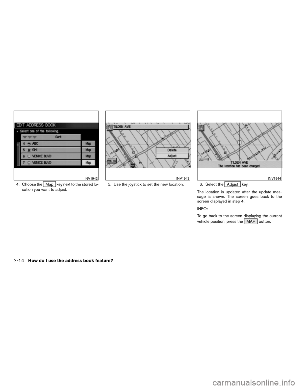
4. Choose theMap key next to the stored lo-
cation you want to adjust.5. Use the joystick to set the new location. 6. Select theAdjust key.
The location is updated after the update mes-
sage is shown. The screen goes back to the
screen displayed in step 4.
INFO:
To go back to the screen displaying the current
vehicle position, press the MAP button.
INV1942INV1943INV1944
7-14How do I use the address book feature?
ZREVIEW COPYÐ2005(nav)
Navigation System OMÐUSA_English(nna)
07/10/04Ðdebbie
X
Page 166 of 192

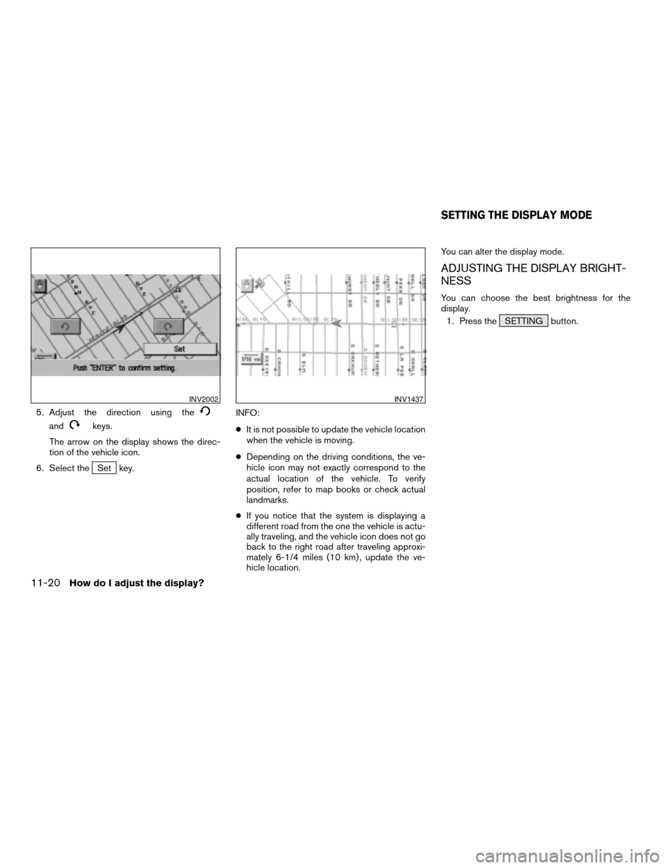
5. Adjust the direction using the
andkeys.
The arrow on the display shows the direc-
tion of the vehicle icon.
6. Select the
Set key.INFO:
cIt is not possible to update the vehicle location
when the vehicle is moving.
cDepending on the driving conditions, the ve-
hicle icon may not exactly correspond to the
actual location of the vehicle. To verify
position, refer to map books or check actual
landmarks.
cIf you notice that the system is displaying a
different road from the one the vehicle is actu-
ally traveling, and the vehicle icon does not go
back to the right road after traveling approxi-
mately 6-1/4 miles (10 km) , update the ve-
hicle location.You can alter the display mode.
ADJUSTING THE DISPLAY BRIGHT-
NESS
You can choose the best brightness for the
display.
1. Press the SETTING button.
INV2002INV1437
SETTING THE DISPLAY MODE
11-20How do I adjust the display?
ZREVIEW COPYÐ2005(nav)
Navigation System OMÐUSA_English(nna)
07/10/04Ðdebbie
X
Page 171 of 192

12 Information on map data discs
How to order map data DVD-ROM updates.........12-2
How to handle the DVD-ROM.....................12-2
About the navigation map DVD-ROM............12-3Icons.........................................12-3
Abbreviations definition list........................12-6
ZREVIEW COPYÐ2005(nav)
Navigation System OMÐUSA_English(nna)
07/10/04Ðdebbie
X
Page 172 of 192

To order updated mapping DVD-ROMs or addi-
tional DVD-ROMs, please contact the NISSAN
Navigation System help desk at:
cADDRESS: P .O. Box 2082, Burlingame, CA
94011
cE-MAIL: [email protected]
cWEB SITE: www.zenrin.com
cPHONE: 1-888-661-9995
cHOURS: 6:00 AM to 5:00 PM (Pacific Time)
CAUTION
cHandle a DVD-ROM by its edges.
Never touch the surface of the disc.
cTo clean a disc, wipe the surface
from the center to the outer edge us-
ing a clean, soft cloth. Do not wipe
the disc using a circular motion.
Do not use a conventional record
cleaner, benzine, thinner or alcohol
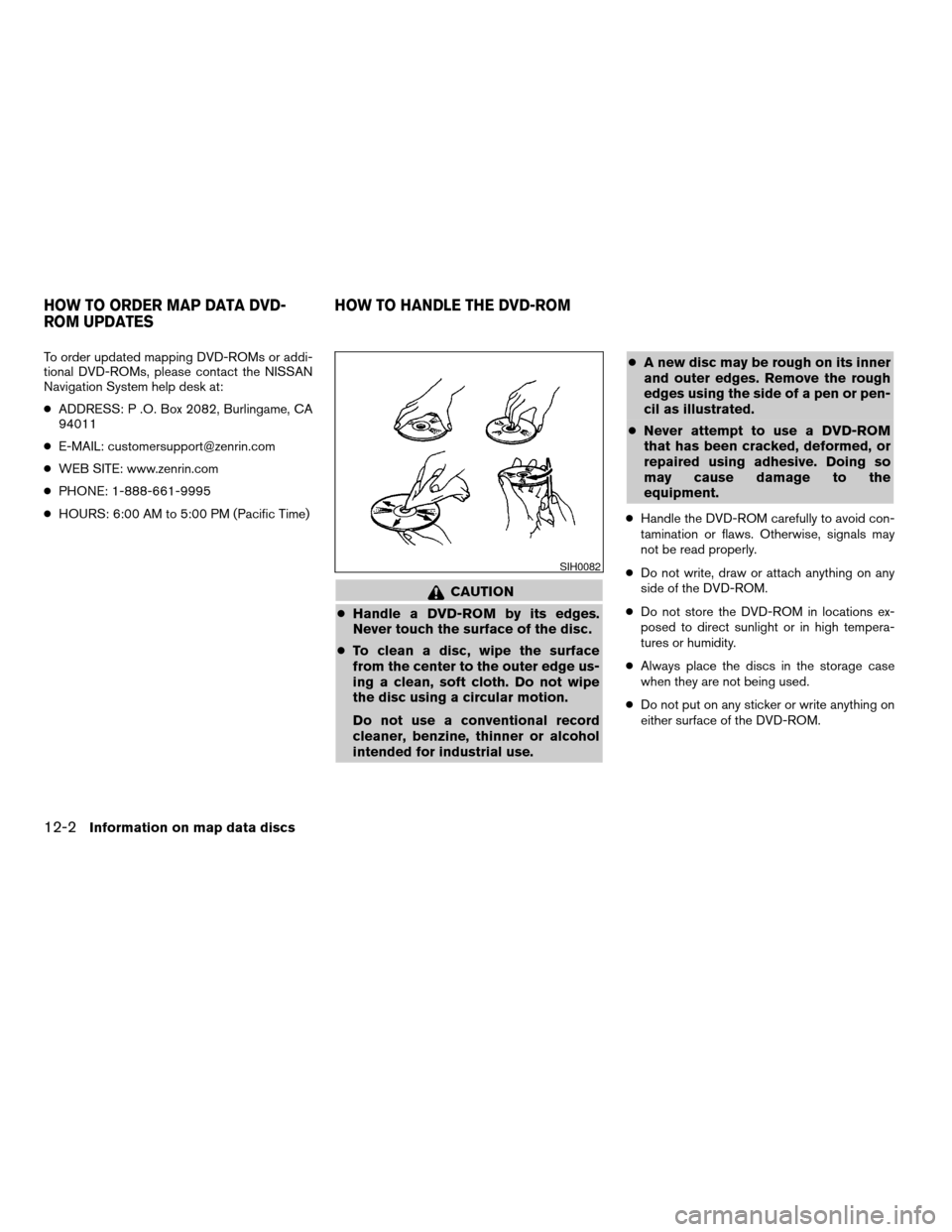
intended for industrial use.cA new disc may be rough on its inner
and outer edges. Remove the rough
edges using the side of a pen or pen-
cil as illustrated.
cNever attempt to use a DVD-ROM
that has been cracked, deformed, or
repaired using adhesive. Doing so
may cause damage to the
equipment.
cHandle the DVD-ROM carefully to avoid con-
tamination or flaws. Otherwise, signals may
not be read properly.
cDo not write, draw or attach anything on any
side of the DVD-ROM.
cDo not store the DVD-ROM in locations ex-
posed to direct sunlight or in high tempera-
tures or humidity.
cAlways place the discs in the storage case
when they are not being used.
cDo not put on any sticker or write anything on
either surface of the DVD-ROM.
SIH0082
HOW TO ORDER MAP DATA DVD-
ROM UPDATESHOW TO HANDLE THE DVD-ROM
12-2Information on map data discs
ZREVIEW COPYÐ2005(nav)
Navigation System OMÐUSA_English(nna)
07/10/04Ðdebbie
X
Page 183 of 192

Symptom Possible cause Remedy
The location of vehicle icon does not match the actual
position.Driving on slippery road surface. If the position marker does not move to the correct position
even after the vehicle has been driven approximately 6
miles (10 km) , adjust the current location. If necessary,
adjust the moving speed of the vehicle. If the symptom still
exists, contact your NISSAN dealer. Driving on slanted area.
Rough or violent driving. If the position marker does not move to the correct position
even after the vehicle has been driven approximately 6
miles (10 km) , adjust the current location.
GPS indicator remains gray. Please check the GPS indicator on the screen to see if it
remains gray. If it remains gray, drive the vehicle to a place
where the GPS can be received.
Because the vehicle has tire chains on, or the system was
transferred to a different vehicle, errors (gain or loss) result
in calculating the speed from the speed pulse.The location of the vehicle icon will move by driving the
vehicle for 30 minutes (in case it is running at 18-3/4
miles/hour (30 km/h)) . If you still notice errors, adjust mov-
ing speed. If the symptom still exists, contact your NISSAN
dealer.
The map data has an error or is incomplete (if the location
error always happens in the same area) .Please wait for the update of the Map DVD-ROM.
Troubleshooting guide13-5
ZREVIEW COPYÐ2005(nav)
Navigation System OMÐUSA_English(nna)
07/10/04Ðdebbie
X
Page 187 of 192

Symptom Possible cause Remedy
Although the system is set with the moving direction as the
preference, it does not find the route by matching the
preference.There is no route found in that direction. This condition is not abnormal.
Route is not indicated. There is no road that can be found by this system close to
the destination.Reset the destination closer to the road displayed in
orange. Especially with roads which have separate lanes
for opposite directions, be careful in setting the destination
or waypoints on it, because results may differ depending
on the lane you choose.
The starting point to the destination is too close. Set more distant destinations.
The present location is about 1,100 miles (1,770 km) away
from the destination.Set the destination to within 1,100 miles (1,770 km) .
The route is not displayed continuously at waypoints, for
example, that are not calculated route from the vehicle’s
current position.Suggested routes may be displayed discontinuously near
waypoints as route calculation is done at each waypoint.This condition is not abnormal.
The suggested route the vehicle has traveled is erased. Suggested routes are stored in memory by the blocks; if
the vehicle travels past waypoint block 1, the previous data
will be erased.This condition is not abnormal.
A route with many detours is suggested. If there are restrictions (such as one-way traffic) on roads
close to the starting point or destination, the system may
suggest a detoured route.Try slightly moving the starting point or destination.
The landmark description does not correspond to the ac-
tual one.This may be caused by insufficient or incorrect data on the
DVD-ROM.Exchange the Map DVD-ROM. The new DVD-ROM will be
updated.
The suggested route does not exactly connect to the start-
ing point, waypoints, or destination.There is no data for route calculation closer to these points. Set these points on the main road displayed in thick
orange. Please note that in some cases even main roads
lack the data for route calculation.
ROUTE CALCULATION
Troubleshooting guide13-9
ZREVIEW COPYÐ2005(nav)
Navigation System OMÐUSA_English(nna)
07/10/04Ðdebbie
X