navigation system NISSAN XTERRA 2013 N50 / 2.G LC2 Navigation Manual
[x] Cancel search | Manufacturer: NISSAN, Model Year: 2013, Model line: XTERRA, Model: NISSAN XTERRA 2013 N50 / 2.GPages: 104, PDF Size: 1.27 MB
Page 99 of 104

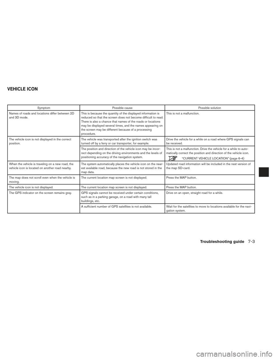
SymptomPossible cause Possible solution
Names of roads and locations differ between 2D
and 3D mode. This is because the quantity of the displayed information is
reduced so that the screen does not become difficult to read.
There is also a chance that names of the roads or locations
may be displayed several times, and the names appearing on
the screen may be different because of a processing
procedure. This is not a malfunction.
The vehicle icon is not displayed in the correct
position. The vehicle was transported after the ignition switch was
turned off by a ferry or car transporter, for example. Drive the vehicle for a while on a road where GPS signals can
be received.
The position and direction of the vehicle icon may be incor-
rect depending on the driving environments and the levels of
positioning accuracy of the navigation system. This is not a malfunction. Drive the vehicle for a while to auto-
matically correct the position and direction of the vehicle icon.
“CURRENT VEHICLE LOCATION” (page 6-4)
When the vehicle is traveling on a new road, the
vehicle icon is located on another road nearby. The system automatically places the vehicle icon on the near-
est available road, because the new road is not stored in the
map data. Updated road information will be included in the next version of
the map SD-card.
The map does not scroll even when the vehicle is
moving. The current location map screen is not displayed.
Press the MAP button.
The vehicle icon is not displayed. The current location map screen is not displayed. Press the MAP button.
The GPS indicator on the screen remains gray. GPS signals cannot be received under certain conditions, such as in a parking garage, on a road with many tall
buildings, etc. Drive on an open, straight road for a while.
A sufficient number of GPS satellites is not available. Wait for the satellites to move to locations available for the navi- gation system.
VEHICLE ICON
Troubleshooting guide7-3
Page 103 of 104

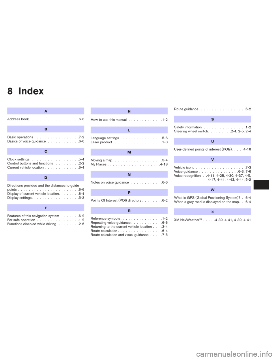
8 Index
A
Address book...................6-3
B
Basic operations .................7-2
Basicsofvoiceguidance ............6-6
C
Clocksettings ..................5-4
Controlbuttonsandfunctions..........2-2
Current vehicle location .............6-4
D
Directions provided and the distances to guide
points.......................6-6
Display of current vehicle location ........6-4
Displaysettings..................5-3
F
Features of this navigation system .......6-2
For safe operation ................1-2
Functions disabled while driving ........2-6
H
Howtousethismanual .............1-2
L
Language settings................5-6
Laser product ...................1-3
M
Movingamap...................3-4
MyPlaces....................4-18
N
Notesonvoiceguidance ............6-6
P
PointsOfInterest(POI)directory........6-2
R
Reference symbols ................1-2
Repeating voice guidance ............6-6
Returning to the current vehicle location ....3-4
Route calculation .................6-4
Route calculation and visual guidance .....7-5Routeguidance..................6-2
S
Safety information
................1-2
Steering wheel switch .........2-4,2-5,2-4
U
User-defined points of interest (POIs).....4-18
V
Vehicleicon....................7-3
Voiceguidance...............6-3,7-6
Voice recognition . .4-11, 4-28, 4-30, 4-37, 4-5,
4-17, 4-41, 4-43, 4-44, 5-2
W
What is GPS (Global Positioning System)? . .6-4
When a gray road is displayed on the map . . .6-4
X
XMNavWeather™.....4-39,4-41,4-39,4-41
Page 104 of 104

®
For your safety, read carefully and keep in this vehicle.
2013 NISSAN NAVIGATION SYSTEM LC2
Printing : December 2012 (04)
Publication No.:
Printed in U.S.A.
LC 2
2013 NAVIGATIONSYSTEM
OWNER’S MANUAL
N13E LC2UX1