PEUGEOT 2008 2013.5 Owners Manual
Manufacturer: PEUGEOT, Model Year: 2013.5, Model line: 2008, Model: PEUGEOT 2008 2013.5Pages: 336, PDF Size: 9.23 MB
Page 221 of 336
04
219
PEUGEOT CONNECT APPS
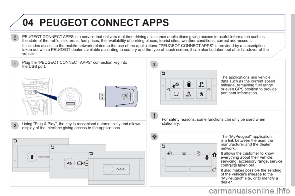
The applications use vehicle data such as the current speed, mileage, remaining fuel range or even GPS position to provide pertinent information.
Plug the "PEUGEOT CONNECT APPS" connection key into the USB port.
The "MyPeugeot" application is a link between the user, the manufacturer and the dealer network.
It allows the customer to know everything about their vehicle: servicing, accessory range, service contracts taken out.
It also makes possible the sending of the vehicle's mileage to the "MyPeugeot" site, or to identify a dealer.
PEUGEOT CONNECT APPS is a service that delivers real-time driving assistance application\
s giving access to useful information such as the state of the traffi c, risk areas, fuel prices, the availability of parking places, tourist sites, weather conditions, correct addresses…
It includes access to the mobile network related to the use of the appli\
cations. "PEUGEOT CONNECT APPS" is provided by a subscription taken out with a PEUGEOT dealer, available according to country and the type of touch screen; it can al\
so be taken out after handover of the vehicle.
For safety reasons, some functions can only be used when stationary. Using "Plug & Play", the key is recognised automatically and allows display of the interface giving access to the applications.
Page 222 of 336
05
220
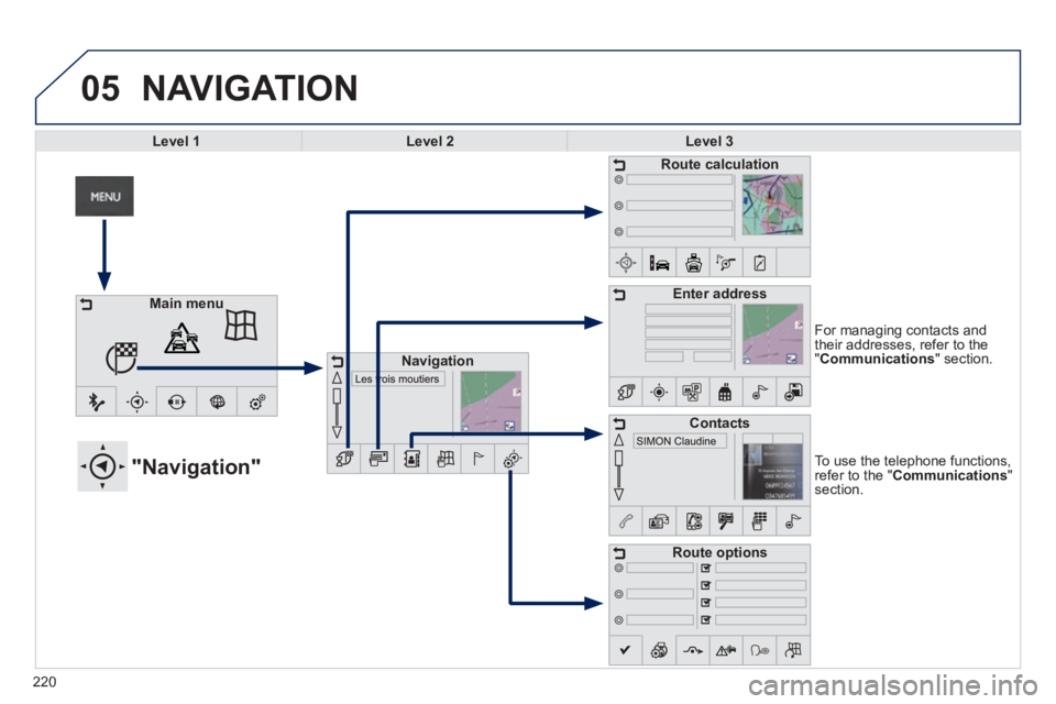
To use the telephone functions, refer to the " Communications " section.
"Navigation"
For managing contacts and their addresses, refer to the " Communications " section.
NAVIGATION
Main menu
Navigation
Route calculation
Enter address
Contacts
Route options
Level 1Level 2Level 3
Page 223 of 336
221
Level 1Level 2Level 3Comments
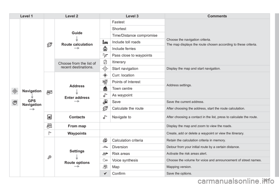
Navigation
GPS Navigation
Guide
Route calculation
Fastest
Choose the navigation criteria.
The map displays the route chosen according to these criteria.
Shortest
Time/Distance compromise
Include toll roads
Include ferries
Pass close to waypoints
Choose from the list of recent destinations.
Itinerary
Start navigation Display the map and start navigation.
Address
Enter address
Curr. location
Address settings. Points of Interest
Town centre
As waypoint
Save Save the current address.
Calculate the route After choosing the address, start the route calculation.
Contacts Navigate to After choosing a contact in the list, press to calculate the route.
From map Display the map and zoom to view the roads.
Waypoints Create, add or delete a waypoint or view the itinerary.
Settings
Route options
Calculation criteria Retain the calculation criteria in memory.
Diversion Detour from your initial route by a certain distance.
Risk areas Activate the risk areas alert.
Voice synthesis Choose the volume for voice and announcement of street names.
Map Mapping version.
Confi rm Save the options.
Page 224 of 336
05
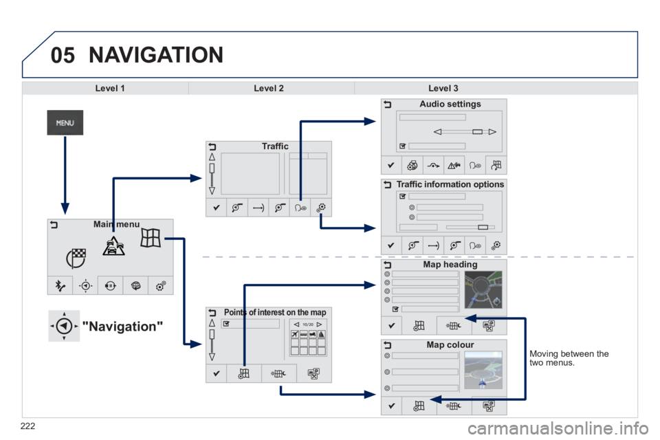
Moving between the two menus.
NAVIGATION
Level 1Level 2Level 3
"Navigation"
Traffi c
Points of interest on the mapPoints of interest on the map
Audio settings
Traffi c information options
Map heading
Map colour
Main menuMain menu
222
Page 225 of 336
223223223
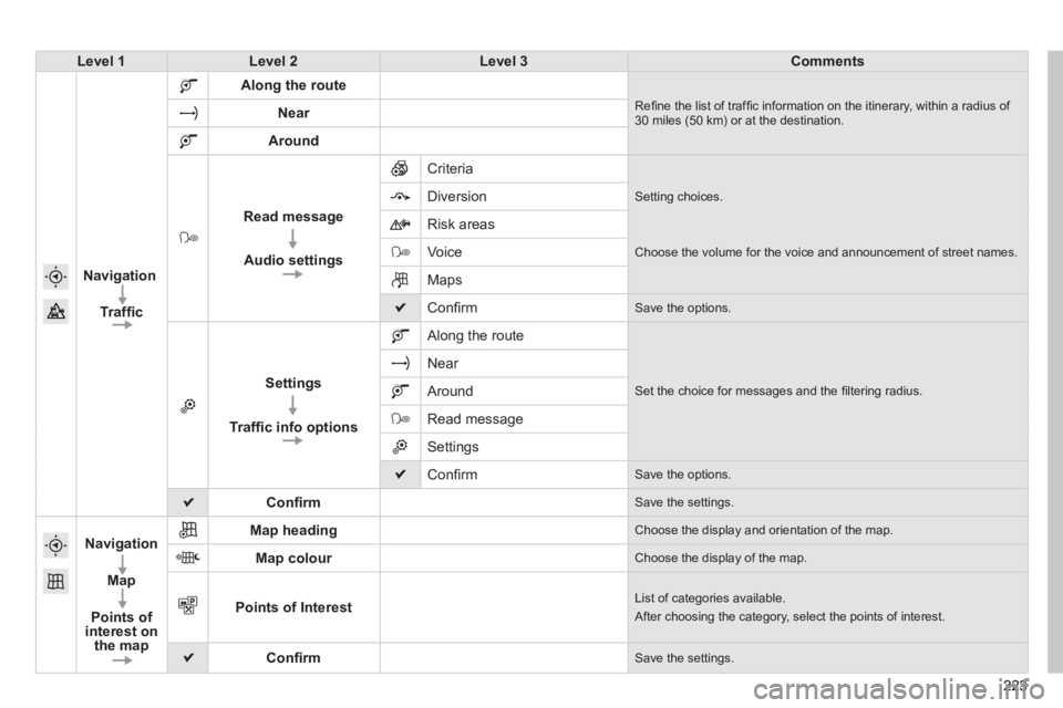
Level 1Level 2Level 3Comments
Navigation
Traffi c
Along the route
Refi ne the list of traffi c information on the itinerary, within a radius of 30 miles (50 km) or at the destination. Near
Around
Read message
Audio settings
Criteria
Setting choices. Diversion
Risk areas
Voice Choose the volume for the voice and announcement of street names.
Maps
Confi rm Save the options.
Settings
Traffi c info options
Along the route
Set the choice for messages and the fi ltering radius.
Near
Around
Read message
Settings
Confi rm Save the options.
Confi rm Save the settings.
Navigation
Map
Points of interest on the map
Map heading Choose the display and orientation of the map.
Map colour Choose the display of the map.
Points of Interest List of categories available.
After choosing the category, select the points of interest.
Confi rm Save the settings.
Page 226 of 336
05
224
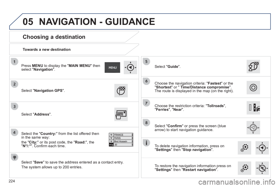
Towards a new destination
Choosing a destination
Select " Navigation GPS ".
Select " Save " to save the address entered as a contact entry.
The system allows up to 200 entries.
Select " Confi rm " or press the screen (blue arrow) to start navigation guidance.
Select " Address ".
Select the " Country: " from the list offered then in the same way:
the " City: " or its post code, the " Road: ", the " N°/:° ". Confi rm each time.
Select " Guide ".
Choose the restriction criteria: " Tollroads ", " Ferries ", " Near ". Near ". Near
Choose the navigation criteria: " Fastest " or the " Shortest " or " Time/Distance compromise ". The route is displayed in the map (on the right).
To delete navigation information, press on " Settings " then " Stop navigation ".
To restore the navigation information press on " Settings " then " Restart navigation ".
Press MENU to display the " MAIN MENU " then select " Navigation ".
NAVIGATION - GUIDANCE
Page 227 of 336
05
225
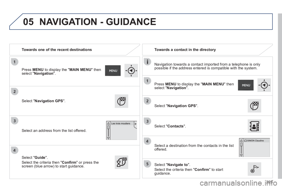
Towards one of the recent destinations Towards a contact in the directory
Navigation towards a contact imported from a telephone is only possible if the address entered is compatible with the system.
Select " Navigation GPS ".
Select an address from the list offered.
Select " Navigation GPS ".
Select " Contacts ".
Select a destination from the contacts in the list offered.
Select " Navigate to ".
Select the criteria then " Confi rm " to start guidance.
Select " Guide ".
Select the criteria then " Confi rm " or press the screen (blue arrow) to start guidance.
Press MENU to display the " MAIN MENU " then select " Navigation ".
Press MENU to display the " MAIN MENU " then select " Navigation ".
NAVIGATION - GUIDANCE
Page 228 of 336
05
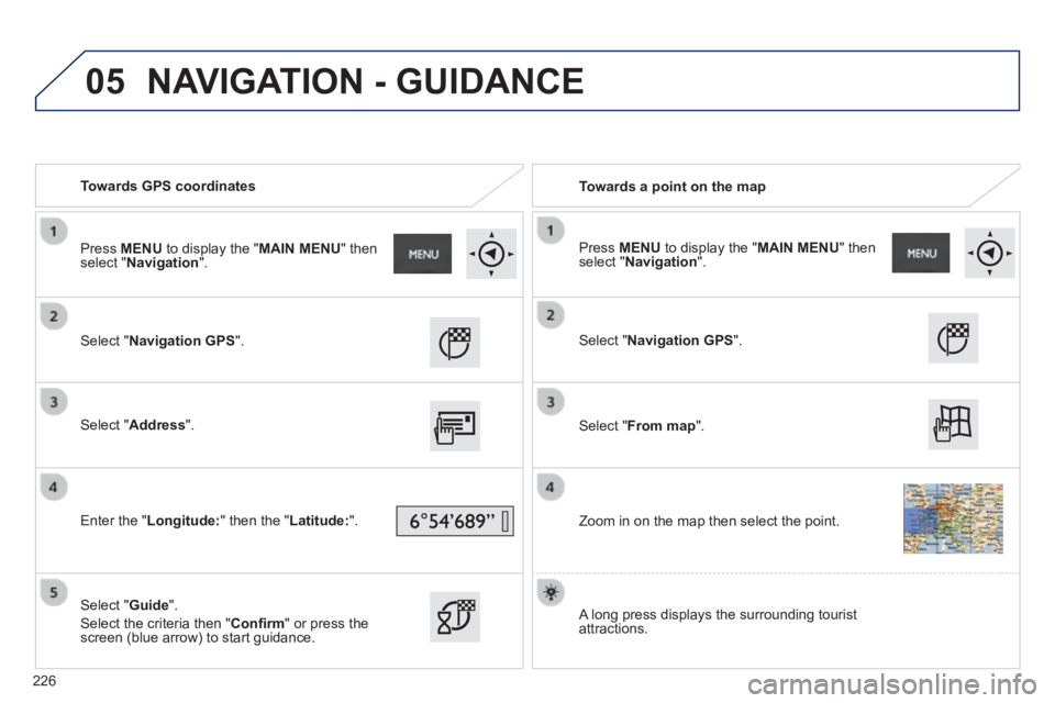
Towards GPS coordinates Towards a point on the map
Select " Navigation GPS ".
Select " Address ".
Enter the " Longitude: " then the " Latitude: ".
Select " Guide ".
Select the criteria then " Confi rm " or press the screen (blue arrow) to start guidance.
Select " Navigation GPS ".
Select " From map ".
Zoom in on the map then select the point.
Press MENU to display the " MAIN MENU " then select " Navigation ". Press MENU to display the " MAIN MENU " then select " Navigation ".
A long press displays the surrounding tourist attractions.
NAVIGATION - GUIDANCE
226
Page 229 of 336
05
227
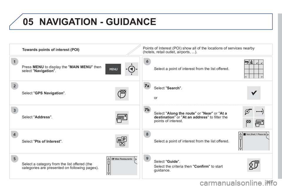
Towards points of interest (POI) Points of Interest (POI) show all of the locations of services nearby \
(hotels, retail outlet, airports, ...).
Select " GPS Navigation ".
Select " Address ".
Select " Pts of Interest ".
Select a category from the list offered (the categories are presented on following pages).
Select " Along the route " or " Near " or " Near " or " NearAt a destination " or " At an address " to fi lter the points of interest.
Select a point of interest from the list offered.
Select " Guide ".
Select the criteria then " Confi rm " to start guidance.
Select " Search ".
or
Select a point of interest from the list offered.
Press MENU to display the " MAIN MENU " then select " Navigation ".
NAVIGATION - GUIDANCE
Page 230 of 336
05
228
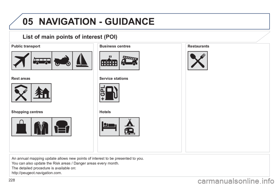
List of main points of interest (POI)
An annual mapping update allows new points of interest to be presented t\
o you.
You can also update the Risk areas / Danger areas every month.
The detailed procedure is available on:
http://peugeot.navigation.com.
Public transport
Rest areas
Shopping centres
Business centres
Service stations
Hotels
Restaurants
NAVIGATION - GUIDANCE