navigation PEUGEOT 308 2016 Owner's Manual
[x] Cancel search | Manufacturer: PEUGEOT, Model Year: 2016, Model line: 308, Model: Peugeot 308 2016Pages: 344, PDF Size: 12.23 MB
Page 268 of 344

04
266
3008_en_Chap12b_RT6-2-8_ed01-2015
NAVIGATION - GUIDANCE
This icon appears when several POIs are grouped
together in the same area. Zooming in on this icon
shows details of the POIs.
Service station
Garage
PEUGEOT
Covered car park
Car park
Rest area
Hotel
Restaurant
Cafeteria
Bed and breakfast Railway station
Bus station
Port
Industrial estate
Supermarket
Vending machine
Sports complex, sports centre,
sports ground
Swimming pool
Winter sports resort Airport
Theme parks
Hospital, Chemist,
Ve t
Police station
Town hall
Post office
Museum, Culture, Theatre,
Historic monument
Tourist information, Tourist
attraction
Risk areas / Danger
areas*
List of principal points of interest (POI)
* According to availability in the country.
School
An annual mapping update allows new points of interest to be presented t\
o you.
You can also update the Risk areas / Danger areas every month.
The detailed procedure is available on:
http://peugeot.navigation.com. Cinema
Page 269 of 344

04
267
3008_en_Chap12b_RT6-2-8_ed01-2015
NAVIGATION - GUIDANCE
Select:
-
"V
isual alert"
-
"Audible alert"
-
"Alert only in guidance"
-
"Overspeed alarm only".
The choice of time of notification defines
how long in advance that Risk area
warnings are given.
Select "
OK" to confirm the screen.
Select "Guidance options
" and confirm,
then select "Set parameters for risk
areas " and confirm. These functions are only available if risk areas have been
downloaded and installed on the system.
The detailed procedure for updating risk area POIs can be found at
http://peugeot.navigation.com.
Press N AV
to display the "Navigation -
guidance" menu.
Settings for risk area / danger area alerts
Page 270 of 344
04
268
3008_en_Chap12b_RT6-2-8_ed01-2015
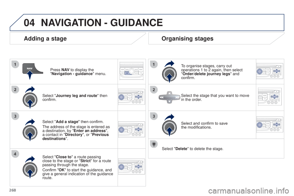
Adding a stage
Press N AV to display the
"Navigation - guidance " menu.
Select "Journey leg and route " then
confirm.
Select "Close to" a route passing
close to the stage or "Strict" for a route
passing through the stage.
Confirm "OK" to start the guidance, and
give a general indication of the guidance
route. Select "Add a stage" then confirm.
The address of the stage is entered as
a destination, by "Enter an address",
a contact in "Directory ", or "Previous
destinations".
Organising stages
To organise stages, carry out
operations 1 to 2 again, then select
"Order/delete journey legs" and
confirm.
Select and confirm to save
the
modifications.
Select the stage that you want to move
in the order.
Select "Delete" to delete the stage.
NAVIGATION - GUIDANCE
Page 271 of 344

04
269
3008_en_Chap12b_RT6-2-8_ed01-2015
Route options
Calculation criteriaSelect "Guidance options " and confirm.
Select "OK" and confirm to save
the
modifications.
Select "Define calculation criteria" and
confirm.
This function allows modification of:
-
the guidance criteria: ("Fastest
route
", "Shortest route",
"Distance/Time"),
-
the exclusion criteria: ("W
ith tolls"
or "With Ferry"),
-
traffic avoidance: ("
Traffic info").
Press N AV
to display the
"Navigation - guidance " menu.
If traffic avoidance (Traffic info) is selected, the system suggests
an alternative route if there is a delay on the guidance route.
NAVIGATION - GUIDANCE
Page 272 of 344

04
270
3008_en_Chap12b_RT6-2-8_ed01-2015
Press N AV to display the
"Navigation - guidance " menu.
Map management
Selecting the points of interest displayed on the map
Select "Map management" and confirm. Select from the various categories the
ones that you want to display on the
screen.
Select "Map details" and confirm. Select "Default" to have only "Filling stations, garages
" and
"Risk areas " appear on the map (if installed in the system).
Select "OK" then confirm and
select
"OK" again then confirm to save
the modifications.
NAVIGATION - GUIDANCE
Page 273 of 344

04
271
3008_en_Chap12b_RT6-2-8_ed01-2015
Select "Map management" and confirm.Select:
-
"Vehicle direction
" to have the map
follow the direction of travel,
- "North direction
" to keep the map
always North up,
- "Perspective view" to display a
perspective view.
Select "Map orientation " and confirm. The colour of the map, different from the day and night mode, is
configured in the "
SETUP" menu.
Map orientation
Press N AV to display the
"Navigation - guidance " menu.
Street names are visible on the map from the 100 m scale.
NAVIGATION - GUIDANCE
Page 274 of 344

04
272
3008_en_Chap12b_RT6-2-8_ed01-2015
Press N AV to display the
"Navigation - guidance " menu.
Navigation voice synthesis
Select "Guidance options " and confirm.
Adjusting the volume / Deactivation
Select "Set speech synthesis" and
confirm. Select the volume graph and confirm.
Select "Deactivate " to deactivate voice messages.
Select "OK" and press the dial
to
confirm.
Adjust the volume to the desired level
and confirm.
The volume of messages can be adjusted during the transmission
of the message using the volume adjustment control.
The volume setting of guidance messages is also accessible via
the "SETUP" / "
Voice synthesis" menu.
NAVIGATION - GUIDANCE
Page 275 of 344

04
273
3008_en_Chap12b_RT6-2-8_ed01-2015
Male voice / Female voicePress SETUP to display the
configuration menu.
Select "Select male voice" or "Select
female voice" then confirm "Ye s " to
activate a male or female voice. The
system restarts. Select "Voice synthesis" and confirm.
NAVIGATION - GUIDANCE
Page 277 of 344
 messages with GPS Navigation provide traffic information in real time.Press t")
05
275
3008_en_Chap12b_RT6-2-8_ed01-2015
Configure the filtering and display of TMC messages
TMC (Traffic Message Channel) messages with GPS Navigation provide traffic information in real time.Press the TRAFFIC button to display the
"Traffic information" menu.
Select the "Geographic filter" function
and confirm. The system offers a choice of:
-
"Retain all the messages",
or
-
"Retain the messages"
●
"
Around the vehicle", (confirm
the mileage to modify and select
the distance),
●
"
On the route".
Confirm "OK" to save the modifications.
We recommend:
-
a filter on the route and
-
a filter around the vehicle of:
-
12 miles (20 km) in urban areas,
-
30 miles (50 km) on motorways.
TRAFFIC INFORMATION
Page 302 of 344

\"Navigation - guidance\"
MENU
Enter an address
Select destination
Directory
GPS coordinates
Journey leg and route
Add a stageEnter a")
11
300
3008_en_Chap12b_RT6-2-8_ed01-2015
SCREEN MENU MAP(S)
"Navigation - guidance"
MENU
Enter an address
Select destination
Directory
GPS coordinates
Journey leg and route
Add a stageEnter an address
Directory Previous destinations
Order/delete journey legs
Divert route
Chosen destination
Guidance options
Define calculation criteria
Delete last destinations
Map management
Map orientation
MAIN FUNCTION
Option A1
Option A11
Option A
Option B...
Map details
Move the map
Mapping and updating
Description of risk areas database
Stop / Restore guidance
1
2
3
1
3
3
2
2
2
2
1
3
1
1
2
2
2
2
2
2
2
2
2
2
1
1
Set parameters for risk areas2
Fastest route2
Shortest route
Distance/Time
With tolls2
2
2
With Ferry2
Traffic info2
Set speech synthesis Fastest route
Shortest route
3
3
2
Distance/Time
With tolls3
3
With Ferry
Traffic info3
3
3
3
3
North direction
Vehicle direction
Perspective view