remote start RENAULT CAPTUR 2013 1.G Carminat Tomtom Navigation Owners Manual
[x] Cancel search | Manufacturer: RENAULT, Model Year: 2013, Model line: CAPTUR, Model: RENAULT CAPTUR 2013 1.GPages: 60, PDF Size: 5.7 MB
Page 9 of 60

Downloaded from www.Manualslib.com manuals search engine JauneNoirNoir texte
7
ENG_UD20965_5
NFA_Présentation commande (XNX - NFA - Renault)
ENG_NW_947-4_TTY_Renault_0
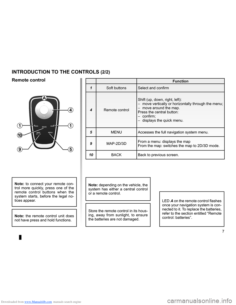
introduction to tHe controLs (2/2)
Function
1 Soft buttons Select and confirm
4 Remote control Shift (up, down, right, left):
–
move vertically or horizontally through the menu;
– move around the map .
Press the central button:
– confirm;
– displays the quick menu .
5 MENU Accesses the full navigation system menu .
9 MAP-2D/3D From a menu: displays the map
From the map: switches the map to 2D/3D mode .
10 BACK Back to previous screen .
LED A on the remote control flashes
once your navigation system is con-
nected to it . To replace the batteries,
refer to the section entitled “Remote
control: batteries” .
note: to connect your remote con -
trol more quickly, press one of the
remote control buttons when the
system starts, before the legal no -
tices appear .
note: the remote control unit does
not have press and hold functions .
remote control
Store the remote control in its hous-
ing, away from sunlight, to ensure
the batteries are not damaged .
a
4
1
5
1
10
9
note: depending on the vehicle, the
system has either a central control
or a remote control .
Page 23 of 60

Downloaded from www.Manualslib.com manuals search engine JauneNoirNoir texte
21
ENG_UD31424_2
NFA/Entrer une destination (XNX - NFA - Renault)
ENG_NW_947-4_TTY_Renault_0
GOVIROFLA Y
CHAVILL ELE CHESNAY
SEVRES
VIROFLA Y
CHA
VILL E
LE CHESNAY SEVRES
L I V E
0:13 \f
9.4 \bm
IQ Routes
20 mai, 9:50
Avenue Roger-Salengr\
o
Chaville
entering a destination (4/4)
“Latitude Longitude ”
This function allows you to define a
destination using latitude and longitude
values .
confirming the destination
Once the destination information has
been entered, the system calculates
the route . By default, it is calculated
using the fastest route .
n ote: the calculation criteria can be
modified in the parameters .
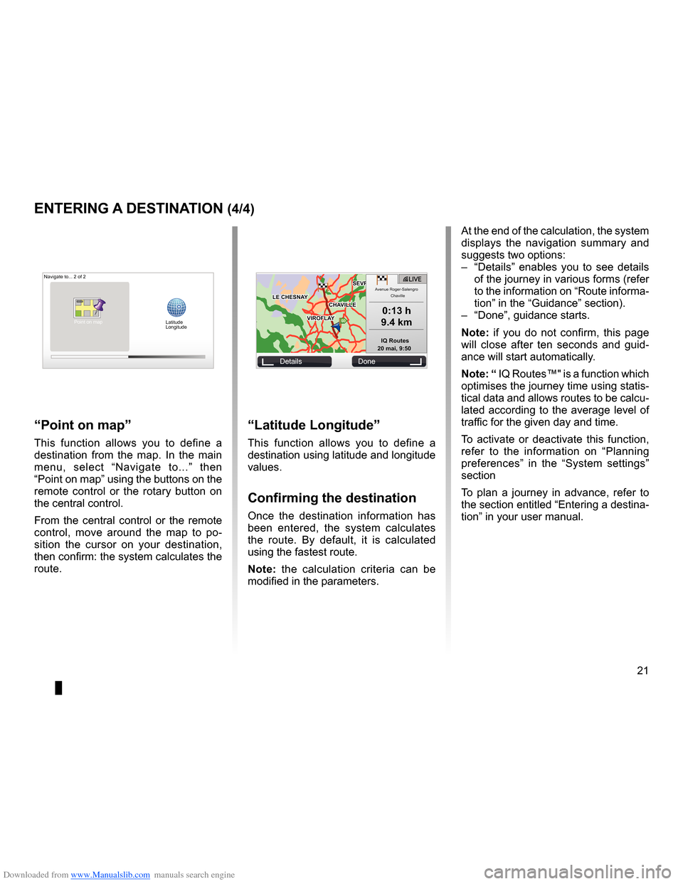
“Point on map ”
This function allows you to define a
destination from the map . In the main
menu, select “ Navigate to . . .” then
“Point on map” using the buttons on the
remote control or the rotary button on
the central control .
From the central control or the remote
control, move around the map to po -
sition the cursor on your destination,
then confirm: the system calculates the
route .
Navigate to . . . 2 of 2
Details Done
Latitude
Longitude
At the end of the calculation, the system
displays the navigation summary and
suggests two options:
– “Details ” enables you to see details
of the journey in various forms (refer
to the information on “Route informa-
tion” in the “Guidance” section) .
– “Done”, guidance starts .
n ote: if you do not confirm, this page
will close after ten seconds and guid -
ance will start automatically .
note: “ IQ Routes™" is a function which
optimises the journey time using statis-
tical data and allows routes to be calcu-
lated according to the average level of
traffic for the given day and time .
To activate or deactivate this function,
refer to the information on “ Planning
preferences ” in the “System settings”
section
To plan a journey in advance, refer to
the section entitled “Entering a destina-
tion” in your user manual .
Point on map