window Seat Leon SC 2017 MEDIA SYSTEM PLUS - NAVI SYSTEM - NAVI SYSTEM PLUS
[x] Cancel search | Manufacturer: SEAT, Model Year: 2017, Model line: Leon SC, Model: Seat Leon SC 2017Pages: 104, PDF Size: 2.7 MB
Page 61 of 104
Navigation
search for points of interest by names or cat-
e g
orie
s. When necessary, enter the name of
the city to refine the search.
››› Fig. 43
APress to open the cursor buttons (, ), which
allow you to move within the text. Address
Aft
er ent
ering a country and a town, you can
start navigating towards the centre of the se-
lected town.
When narrowing down the destination ad-
dress, please note that every entry restricts
the available range of subsequent selections.
For instance, if the street you are looking for
is not in the postcode area you have selected
in a previous window, you will not be able to
find the street at the street selection stage.
Function button: function
Country: To select the desired country.
City: To enter the desired city or postcode.
Street: To enter the desired street name.
House number: To enter the desired house number.
Junction: To select the desired intersection.
Last destinations: Open the My destinations menu
››› page 60.
Start: Start route guidance to the selected address. Using the
● Select the destination on the map or enter
it u
s
ing GPS coordinates and confirm with
OK .
Function button: function
Save: To save the selected point of interest in the desti-
nation memory ››› page 60.
Edit: To edit a destination or to enter another destina-
tion.
Route options: To adjust route options, see Navigation
Setup ››› page 67.
Start: Starts guided navigation to the selected point of
interest. After starting route guidance
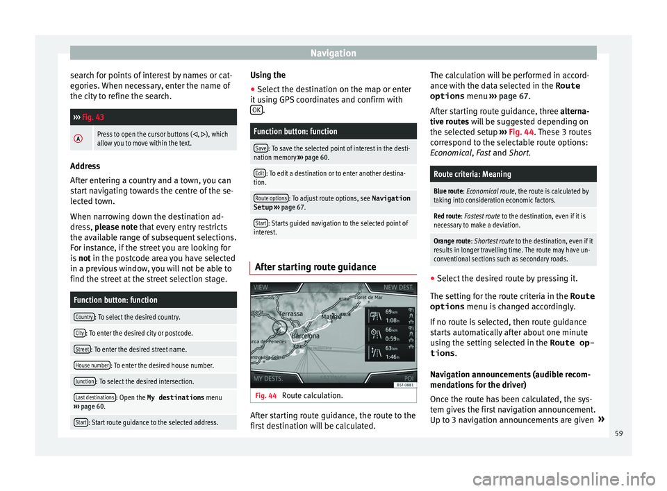
Fig. 44
Route calculation. After starting route guidance, the route to the
fir
s
t
destination will be calculated. The calculation will be performed in accord-
ance with the d
ata selected in the Route
options menu ››› page 67.
After starting route guidance, three alterna-
tive routes will be suggested depending on
the selected setup ››› Fig. 44. These 3 routes
correspond to the selectable route options:
Economical, Fast and Short.
Route criteria: Meaning
Blue route: Economical route, the route is calculated by taking into consideration economic factors.
Red route: Fastest route to the destination, even if it is
necessary to make a deviation.
Orange route: Shortest route to the destination, even if it
results in longer travelling time. The route may have un-
conventional sections such as secondary roads. ●
Select the desired route by pressing it.
The settin g f
or the r
oute criteria in the Route
options menu is changed accordingly.
If no route is selected, then route guidance
starts automatically after about one minute
using the setting selected in the Route op- tions .
Navigation announcements (audible recom-
mendations for the driver)
Once the route has been calculated, the sys-
tem gives the first navigation announcement.
Up to 3 navigation announcements are given »
59
Page 63 of 104
Navigation
● Pr e
s
s the My dests. function button in the
m ain
Na
vigation menu.
● Select the desired function button.
Store po
sition ,
R
out
e s ,
D
e
s tinations ,
La s
t
destinations or
Home a
d
dr ess .
St or
e po
sition
● By pressing the Store po
sition function but-
t on, the
v
ehicle's current position is stored
as a Flagged destination in the destina-
tion memory.
To permanently store the saved position as a
Flagged destination , it must be re-
named in the destination memory. Otherwise
the stored position will be overwritten the
next time a flagged destination is stored.
● Mark the Flagged destination in the
destin
ation memory.
● Press the Store function button.
The n ame c
an be c
hanged in the following in-
put window. Press the function button to
s t
or
e the destination.
Routes
In the Route mode, you can define various
destinations (final destination and stop-
overs).
The starting point of a route is always the
current vehicle position determined by the In-
fotainment system. The destination is the end point of a route.
Stopov
er destinations
are driven to before the destination.
● In the Navigation main menu, press the
My
Dests. function button.
● Press the R
out
e
s function button. The
r out
e
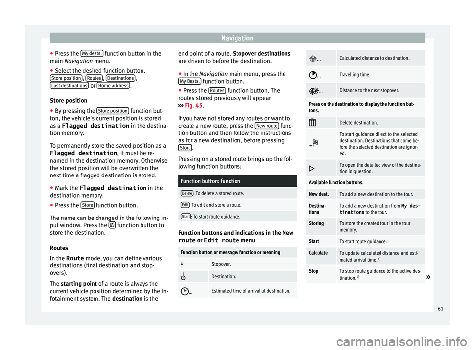
s stored previously will appear
››› Fig. 45.
If you have not stored any routes or want to
create a new route, press the New route func-
tion b utt
on and then f
ollow the instructions
as for a new destination, before pressing Store .
Pr e
s
sing on a stored route brings up the fol-
lowing function buttons:
Function button: function
Delete: To delete a stored route.
Edit: To edit and store a route.
Start: To start route guidance. Function buttons and indications in the
New
route or Edit route menu
Function button or message: function or meaning
Stopover.
Destination.
...Estimated time of arrival at destination.
...Calculated distance to destination.
...Travelling time.
...Distance to the next stopover.
Press on the destination to display the function but-
tons.
Delete destination.
To start guidance direct to the selected
destination. Destinations that come be-
fore the selected destination are ignor-
ed.
To open the detailed view of the destina-
tion in question.
Available function buttons.
New dest.To add a new destination to the tour.
Destina-
tionsTo add a new destination from My des-
tinations
to the tour.
StoringTo store the created tour in the tour
memory.
StartTo start route guidance.
CalculateTo update calculated distance and esti-
mated arrival time. a)
StopTo stop route guidance to the active des-
tination.b)» 61
Page 67 of 104
Navigation
Dynamic route guidance
In or der f
or dy
namic route guidance to func-
tion, Dynamic route must be activated in
the route options ››› page 67.
If during route guidance a traffic report is re-
ceived that affects the route being travelled,
an alternative route will be searched for if the
Infotainment system calculates that time can
be saved.
If it calculates that time will not be saved us-
ing the alternative route, it will continue on
the route with the traffic congestion. An an-
nouncement will be made in each case.
Shortly before arriving at the announced con-
gested traffic, it will be announced once
again.
Avoiding congestion by following the instruc-
tions of a traffic report does not always save
time as the alternate roads may be at a
standstill. The quality of the dynamic route
guidance depends on the information con-
tained in the traffic reports.
The remainder of the route to be travelled
may be manually excluded to cause a new
route calculation ››› page 60.
Traffic reports on map (selection)
Symbol: Meaning
: Traffic congestion
Symbol: Meaning
: Traffic jam
: Accident
: Slippery road surface (ice or snow)
: Slippery road surface
: Danger
: Road works
: Strong wind
: Road closed to traffic
During route guidance, traffic congestion that
doe
s
not
affect the route calculated is dis-
played in grey.
The extent of the traffic congestion along the
route calculated is shown by a red line.
Any incidents that affect the route calculated
and have caused the route to be recalculated
are displayed in orange.
The position of a symbol indicates the start
of the traffic congestion if it is clearly defined
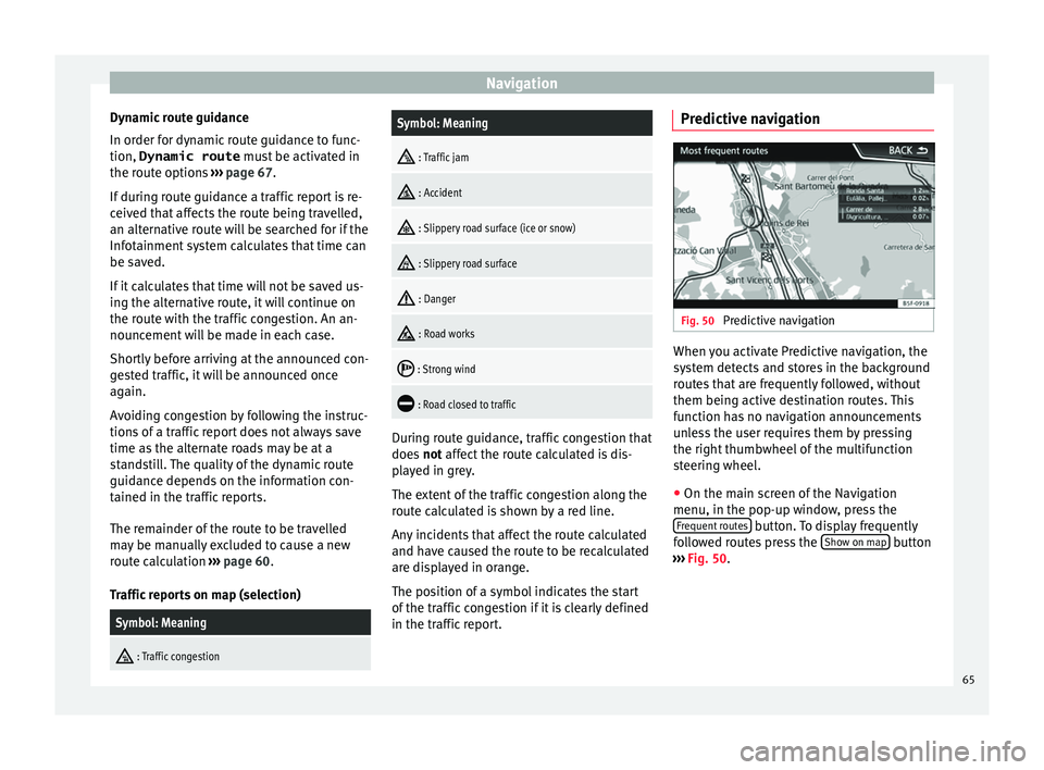
in the traffic report. Predictive navigation
Fig. 50
Predictive navigation When you activate Predictive navigation, the
sy s
t
em detects and stores in the background
routes that are frequently followed, without
them being active destination routes. This
function has no navigation announcements
unless the user requires them by pressing
the right thumbwheel of the multifunction
steering wheel.
● On the main screen of the Navigation
menu, in the pop-up window
, press the
Frequent routes button. To display frequently
f o
l
lowed routes press the Show on map button
› ›
›
Fig. 50.
65
Page 69 of 104
Navigation
Road sign indicators The road sign indicators must be active in the
Navigation Setup menu ›››
page 67.
If road signs for the road being travelled are
stored in the navigation data, the system can
show them on the map display (e.g. a speed
restriction).
Please bear in mind how recent the naviga-
tion data is and the limitations of the system
››› page 56 !
Traffic sign recognition Some vehicles are also equipped with a cam-
er
a f
or tr
affic sign recognition. If traffic sign
recognition is installed in the vehicle and ac-
tivated, the recognised traffic signs and addi-
tional information are displayed in the map
view.
Read and take note of the information and in-
dications provided by the traffic sign recogni-
tion system in the vehicle ›››
Booklet Instruc-
tion Manual.
Route guidance in demo mode If demo mode is activated in the
Naviga-
tion Settings menu ››
›
page 67, an ad-
ditional pop-up window opens when you
start route guidance. ●
Pres
sing the Demo mode function button
s t
ar
ts a “virtual route guidance” to the desti-
nation you have entered.
● If you press the Normal function button, a
“r e
al
route guidance” starts.
The sequence of events and the operations in
virtual route guidance are similar to those in
real route guidance.
Virtual route guidance is repeated when you
reach the fictitious destination and always
starts again from the starting point if not
aborted beforehand.
If the starting point for demo mode has been
defined manually in the Navigation Set-
tings menu, virtual route guidance will start
from the position set.
A manually entered starting point is overwrit-
ten with the current vehicle location if the ve-
hicle moves off. Note
Disable demo mode after use, otherwise you
wi l
l be prompted to choose between virtual
and normal route guidance each time you
start route guidance. Navigation settings
Settin g
s ●
Press the SET
TINGS function button in the
main Na
vigation menu.
Function button: function
Route options: To make adjustments to route calculation.
Suggest 3 alternative routes: After starting route guid-
ance, 3 alternative routes are suggested ››› page 59.
Route: Select the route type.
Economical: The route is calculated by taking into
consideration economic factors.
Fast: The fastest route to the destination.
Short: shortest route to the destination, even if it
results in a longer travelling time.
Most frequent routes: Information on the user's most
frequent routes.
Dynamic route: Dynamic route guidance is activated
when a TMC is received ››› page 64.
Avoid motorways and highways: Motorways will be ex-
cluded from the calculation whenever possible.
Avoid ferries and motorail trains: Ferries and motorail
trains will not be considered in the calculation of the
route whenever possible.
Avoid toll roads: Toll roads will be excluded from the
calculation whenever possible.
Avoid tunnels: Tunnels will be excluded from the cal-
culation whenever possible.» 67
Page 71 of 104
NavigationFunction button: function
Define demo mode starting point: if demo mode is acti-
vated, a fictitious starting point for virtual route
guidance can be defined when the vehicle is sta-
tionary.
Waypoint modeb) : To start Offroad navigation.
a) This function depends on the country.
b) Only available for the model: “Navi System Plus”.
Navigation in Offroad mode*
Introduction 3 Only
available for the model: Navi System Plus
O
ffroad* navigation is a function for offroad
driving that provides directions in “non-digi-
tised areas” at low speeds.
Non-digitised areas are areas about which
the system does not have information for the
streets or terrain. It does not detect streets,
buildings or natural limits such as mountains
or rivers, although they may be shown on the
map.
Offroad* navigation is not suitable for driving
on conventional roads as it does not detect
one-way streets, motorway entries or similar. Offroad Navigation Menu 3 Only available for the model: Navi System Plus
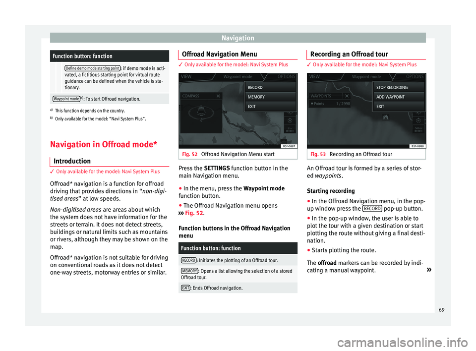
Fig. 52
Offroad Navigation Menu start Press the
SETTINGS function button in the
m ain Nav
igation menu.
● In the menu, press the Way
point mode
function button.
● The Offroad Navigation menu opens
›››
Fig. 52.
Function buttons in the Offroad Navigation
menu
Function button: function
RECORD: Initiates the plotting of an Offroad tour.
MEMORY: Opens a list allowing the selection of a stored
Offroad tour.
EXIT: Ends Offroad navigation. Recording an Offroad tour
3 Only available for the model: Navi System Plus
Fig. 53
Recording an Offroad tour An Offroad tour is formed by a series of stor-
ed wa
ypoin
t
s.
Starting recording
● In the Offroad Navigation menu, in the pop-
up window pr
ess the RECORD pop-up button.
● In the pop-up window, the user is able to
p lot
the t
our with a given destination or start
plotting the route without giving a final desti-
nation.
● Starts plotting the route.
The offroa
d markers can be recorded by indi-
cating a manual waypoint. »
69
Page 73 of 104
Navigation
●
The gener a
l direction of travel is indicated
straight ahead by direction arrows in the In-
fotainment System pop-up window ››› Fig. 55
A .
Note
If an Offroad tour is being recorded, this is
aut omatic
ally stored if Offroad navigation is
discontinued. 71
Page 86 of 104
Telephone management system (PHONE)
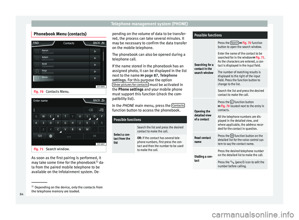
Phonebook Menu (contacts) Fig. 70
Contacts Menu. Fig. 71
Search window. As soon as the first pairing is performed, it
m
a
y
take some time for the phonebook 1)
da-
ta from the paired mobile telephone to be
available on the Infotainment system. De- pending on the volume of data to be transfer-
red, the proc
ess can take several minutes. It
may be necessary to confirm the data transfer
on the mobile telephone.
The phonebook can also be opened during a
telephone call.
If the name stored in the phonebook has an
assigned photo, it can be displayed in the list
next to the name ››› page 87, Telephone
settings. For this purpose the option Show pictures for contacts must be activated in
the Phone settin g
s
and your mobile phone
must support this function (check the com-
patibility list).
In the PHONE main menu, press the Contacts function button to access the phonebook.
Possible functions
Select a con-
tact from the
list
Search the list and press the desired
contact to make the call.
OR: If the contact has several tele-
phone numbers, first press the con-
tact and then the number to be used
to make the call.
Possible functions
Searching for a
contact in the
search window
Press the
Search
››› Fig. 70 function
button to open the search window.
Enter the name of the contact to be
searched for in the window ››› Fig. 71.
As the characters are entered, a con-
tact is displayed in the input field.
The number of matching results is
displayed to the right of the input
field. Press the function button to
change to the list.
Search the list and press the desired
contact to make the call.
Opening the
detailed view
of a contact
Press the function button
››› Fig. 70 located next to the entry in
contacts.
All the telephone numbers are dis-
played in the detailed view, and
where applicable, the address recor-
ded for the contact in question.
Read contact
namePress the function button on the
detailed list for the voice control sys-
tem to say the contact name.
Dialling a con-
tact
Press the desired telephone number
on the detailed list to make the call.
Press the (pencil) icon to edit the
number before calling. 1)
Depending on the device, only the contacts from
the tel ephone memor
y are loaded.
84
Page 100 of 104
Index
short messages (SMS) . . . . . . . . . . . . . . . . . . . . 85
t el
ephone m
anagement system . . . . . . . . . 77, 80
user profile settings . . . . . . . . . . . . . . . . . . . . . . 87
voice control . . . . . . . . . . . . . . . . . . . . . . . . . . . . 13
Physical buttons see: Infotainment system buttons . . . . . . . . . . . . 9
Play CD . . . . . . . . . . . . . . . . . . . . . . . . . . . . . . . . . . . . 46
DVD . . . . . . . . . . . . . . . . . . . . . . . . . . . . . . . . . . . 46
external data storage device (USB) . . . . . . . . . . 47
MEDIA . . . . . . . . . . . . . . . . . . . . . . . . . . . . . . . . . 41
RADIO . . . . . . . . . . . . . . . . . . . . . . . . . . . . . . . . . 29
SD card . . . . . . . . . . . . . . . . . . . . . . . . . . . . . . . . 41
Playback AUX-IN . . . . . . . . . . . . . . . . . . . . . . . . . . . . . . . . . 48
Playing track . . . . . . . . . . . . . . . . . . . . . . . . . . . . . . . . . . . 44
POI importing . . . . . . . . . . . . . . . . . . . . . . . . . . . . . . 66
Points of interest . . . . . . . . . . . . . . . . . . . . . . . . . . 62
Pop-up windows . . . . . . . . . . . . . . . . . . . . . . . . . . . 10
Predictive navigation . . . . . . . . . . . . . . . . . . . . . . . 65
Q Quick reference guide . . . . . . . . . . . . . . . . . . . . . . . 7
R
RADIO . . . . . . . . . . . . . . . . . . . . . . . . . . . . . . . . . . . 29 additional DAB services . . . . . . . . . . . . . . . . . . . 31
additional DAB stations . . . . . . . . . . . . . . . . . . . 31
AM setup . . . . . . . . . . . . . . . . . . . . . . . . . . . . . . . 35
change frequency . . . . . . . . . . . . . . . . . . . . . . . . 29
DAB display . . . . . . . . . . . . . . . . . . . . . . . . . . . . . 31
DAB operation . . . . . . . . . . . . . . . . . . . . . . . . . . . 31
DAB preset list . . . . . . . . . . . . . . . . . . . . . . . . . . 31
DAB Radio Text . . . . . . . . . . . . . . . . . . . . . . . . . . 31
DAB settings . . . . . . . . . . . . . . . . . . . . . . . . . . . . 36 DAB station information . . . . . . . . . . . . . . . . . . . 31
DAB st
ation tracking in FM . . . . . . . . . . . . . . . . . 31
DAB transmission standards . . . . . . . . . . . . . . . 31
EON . . . . . . . . . . . . . . . . . . . . . . . . . . . . . . . . . . . 34
FM setup . . . . . . . . . . . . . . . . . . . . . . . . . . . . . . . 35
information and icons . . . . . . . . . . . . . . . . . . . . 29
main menu . . . . . . . . . . . . . . . . . . . . . . . . . . . . . 29
memory buttons . . . . . . . . . . . . . . . . . . . . . . . . . 32
radio mode . . . . . . . . . . . . . . . . . . . . . . . . . . . . . 29
radio text (RDS) . . . . . . . . . . . . . . . . . . . . . . . . . . 30
RDS . . . . . . . . . . . . . . . . . . . . . . . . . . . . . . . . . . . 30
SCAN function . . . . . . . . . . . . . . . . . . . . . . . . . . . 34
select stations . . . . . . . . . . . . . . . . . . . . . . . . . . 33
setting a station name . . . . . . . . . . . . . . . . . . . . 30
settings . . . . . . . . . . . . . . . . . . . . . . . . . . . . . . . . 35
station list . . . . . . . . . . . . . . . . . . . . . . . . . . . . . . 33
station names display . . . . . . . . . . . . . . . . . . . . 30
station tracking by RDS . . . . . . . . . . . . . . . . . . . 30
store station logos . . . . . . . . . . . . . . . . . . . . . . . 32
store stations . . . . . . . . . . . . . . . . . . . . . . . . . . . 33
TP (traffic news) . . . . . . . . . . . . . . . . . . . . . . . . . 34
traffic announcement (INFO) . . . . . . . . . . . . . . . 34
traffic news (TP) . . . . . . . . . . . . . . . . . . . . . . . . . 34
tune stations . . . . . . . . . . . . . . . . . . . . . . . . . . . . 33
tune the frequency of the stations . . . . . . . . . . 33
Radio text (RDS) . . . . . . . . . . . . . . . . . . . . . . . . . . . 30
Random play (Mix) . . . . . . . . . . . . . . . . . . . . . . . . . 41
RDS . . . . . . . . . . . . . . . . . . . . . . . . . . . . . . . . . . . . . 30 automatic station tracking . . . . . . . . . . . . . . . . . 30
regional RDS . . . . . . . . . . . . . . . . . . . . . . . . . . . . 30
TP (traffic news) . . . . . . . . . . . . . . . . . . . . . . . . . 34
Repeat . . . . . . . . . . . . . . . . . . . . . . . . . . . . . . . . . . . 41
Repeat function (Repeat) . . . . . . . . . . . . . . . . . . . . 41
Requirements for data storage devices and files . . . . . . . . . . . . . . 37
Reset factory settings . . . . . . . . . . . . . . . . . . . . . . 90
Road sign indicators . . . . . . . . . . . . . . . . . . . . . . . 67 Rotary knobs . . . . . . . . . . . . . . . . . . . . . . . . . . . . . . . 9
Route guid
ance
demo mode . . . . . . . . . . . . . . . . . . . . . . . . . . . . . 67
dynamic . . . . . . . . . . . . . . . . . . . . . . . . . . . . . . . . 65
S Safety Instructions Infotainment system . . . . . . . . . . . . . . . . . . . . . . 7
SCAN MEDIA . . . . . . . . . . . . . . . . . . . . . . . . . . . . . . . . . 41
radio . . . . . . . . . . . . . . . . . . . . . . . . . . . . . . . . . . 34
SCAN function RADIO . . . . . . . . . . . . . . . . . . . . . . . . . . . . . . . . . 34
Scan (SCAN) MEDIA . . . . . . . . . . . . . . . . . . . . . . . . . . . . . . . . . 41
SD Card see: memory card . . . . . . . . . . . . . . . . . . . . . . . . 46
Search . . . . . . . . . . . . . . . . . . . . . . . . . . . . . . . . . . . 58
Search lists . . . . . . . . . . . . . . . . . . . . . . . . . . . . . . . 11
SEAT Media Control . . . . . . . . . . . . . . . . . . . . . . . . 26 data transmission and control functions . . . . . 26
Settings bluetooth . . . . . . . . . . . . . . . . . . . . . . . . . . . . . . 87
DAB . . . . . . . . . . . . . . . . . . . . . . . . . . . . . . . . . . . 36
default setting . . . . . . . . . . . . . . . . . . . . . . . . . . 90
factory settings . . . . . . . . . . . . . . . . . . . . . . . . . . 90
images . . . . . . . . . . . . . . . . . . . . . . . . . . . . . . . . . 54
main menu . . . . . . . . . . . . . . . . . . . . . . . . . . . . . 90
Media . . . . . . . . . . . . . . . . . . . . . . . . . . . . . . . . . 53
menu and system settings . . . . . . . . . . . . . . . . . 90
navigation . . . . . . . . . . . . . . . . . . . . . . . . . . . . . . 67
PHONE . . . . . . . . . . . . . . . . . . . . . . . . . . . . . . . . . 87
radio . . . . . . . . . . . . . . . . . . . . . . . . . . . . . . . . . . 35
sound . . . . . . . . . . . . . . . . . . . . . . . . . . . . . . . . . 91
system . . . . . . . . . . . . . . . . . . . . . . . . . . . . . . . . . 90
user profile settings . . . . . . . . . . . . . . . . . . . . . . 87
video . . . . . . . . . . . . . . . . . . . . . . . . . . . . . . . . . . 53
98