change SKODA RAPID SPACEBACK 2016 1.G Amundsen Bolero Infotainment System Navigation Manual
[x] Cancel search | Manufacturer: SKODA, Model Year: 2016, Model line: RAPID SPACEBACK, Model: SKODA RAPID SPACEBACK 2016 1.GPages: 76, PDF Size: 9.64 MB
Page 48 of 76
Navigation
Introductory information
Navigation - function sequence
Applies to Amundsen.
Route guidance is started as follows.
›
Search for/ enter a new destination or Select one of the stored destinations.
›
Confirm the route calculation in the destination details or if necessary, adjust
the route options.
›
Select the preferred route type, if this is requested by the device.
A route calculation occurs and route guidance starts.
The route guidance is provided by graphical driving recommendations and nav- igation announcements.
The is an option to add additional destinations during route guidance, or to
adapt the route.
If a traffic radio station is available, information concerning traffic delays is
evaluated by the device and, if necessary, an alternative route is offered.
If you deviate from the route, then a new route calculation is carried out.
GPS satellite signal
The unit uses the GPS (Global Positioning System) satellite signal for route
guidance.
Outside the range of the GPS satellite signal (e.g. in dense vegetation, in tun-
nels, parking garages, etc.), the unit navigates only with restrictions using ve-
hicle sensors.
The unit offers the possibility to show in the split screen display the following
Position
» Fig. 50 on page 47 information about the current geographical posi-
tion of the vehicle and the satellite signal.
Geographical longitude
Geographical latitude
Elevation
Number of received/available satellites
If no GPS satellite signal is available, no values are displayed.
Navigation data
Navigation data source
The navigation data is stored on an Original SD Card .
In order to ensure the function of the navigation, the Original SD card, with the
navigation data, must be inserted in the respective slot » page 24, SD card .
If the original SD card should be damaged or lost, a new original SD card can be
purchased from the ŠKODA Original Accessories.
With a Non-original SD Card, the navigation does not work .
Finding out the version of the navigation data›
In the Navigation main menu, tap on the function surface,
Tap
→
versioninformation
.
Update navigation data
We recommend that you update the navigation data on a regular basis (e.g.
Due to newly developed roads and changed traffic signs).
The information on updating the navigation data is to be obtained from a
ŠKODA partner or on the following ŠKODA Internet pages.
http://go.skoda.eu/infotainment
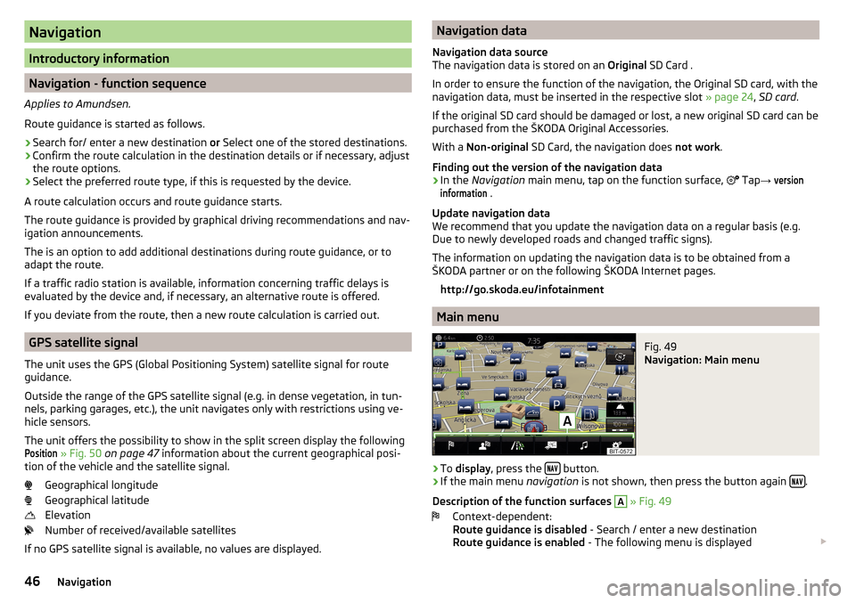
Main menu
Fig. 49
Navigation: Main menu
›
To display , press the button.
›
If the main menu
navigation is not shown, then press the button again .
Description of the function surfaces
A
» Fig. 49
Context-dependent:
Route guidance is disabled - Search / enter a new destination
Route guidance is enabled - The following menu is displayed
46Navigation
Page 51 of 76
If several places were found, then the list can be scrolled through by turning
the controller or sliding the slider.
Note
■
While entering a street name there is an option to enter the centre of a given
place as a destination instead of a street name by tapping the function surfaceCentre
.
■
After entering the street name, the house number or intersection can be en-
tered using the name / number of the intersecting road.
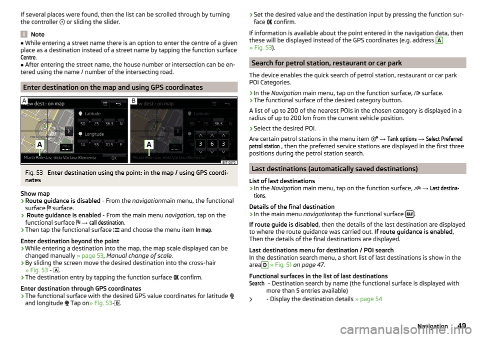
Enter destination on the map and using GPS coordinates
Fig. 53
Enter destination using the point: in the map / using GPS coordi-
nates
Show map
›
Route guidance is disabled - From the navigationmain menu, the functional
surface surface.
›
Route guidance is enabled
- From the main menu navigation, tap on the
functional surface
→
call destination
.
›
Then tap the functional surface
and choose the menu item
In map
.
Enter destination beyond the point
›
While entering a destination into the map, the map scale displayed can be
changed manually » page 53, Manual change of scale .
›
By sliding the screen move the desired destination into the cross-hair
» Fig. 53 -
.
›
The destination entry by tapping the function surface
confirm.
Enter destination through GPS coordinates
›
The functional surface with the desired GPS value coordinates for latitude
and longitude
Tap on » Fig. 53 -
.
›Set the desired value and the destination input by pressing the function sur-
face confirm.
If information is available about the point entered in the navigation data, then
these will be displayed instead of the GPS coordinates (e.g. address A
» Fig. 53 ).
Search for petrol station, restaurant or car park
The device enables the quick search of petrol station, restaurant or car park
POI Categories.
›
In the Navigation main menu, tap on the function surface,
surface.
›
The functional surface of the desired category button.
A list of up to 200 of the nearest POIs in the chosen category is displayed in a
radius of up to 200 km from the current vehicle position.
›
Select the desired POI.
Are certain petrol stations in the menu item
→
Tank options
→
Select Preferredpetrol station
, then the preferred service stations are displayed in the first three
positions during the petrol station search.
Last destinations (automatically saved destinations)
List of last destinations
›
In the Navigation main menu, tap on the function surface,
→
Last destina-tions
.
Details of the final destination
›
In the main menu navigationtap the functional surface .
If route guide is disabled , then the details of the last destination are displayed
to where the route guidance was carried out. If route guidance is enabled,
Then the details of the final destinations are displayed.
Last destinations menu for destination / POI search
In the destination search menu, a short list of last destinations is show in the
area
D
» Fig. 51 on page 47 .
Functional surfaces in the list of last destinations - Destination search by name (the functional surface is displayed with
more than 5 entries available)
- Display the destination details » page 54
Search49Navigation
Page 55 of 76
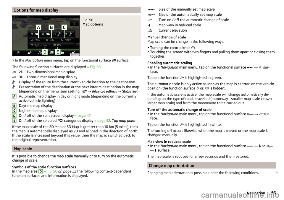
Options for map displayFig. 58
Map options
›
In the Navigation main menu, tap on the functional surface
surface.
The following function surfaces are displayed » Fig. 58.
2D - Two-dimensional map display
3D - Three-dimensional map display
Display of the route from the current vehicle location to the destination
Presentation of the destination or the next interim destination in the map
(depending on the menu item setting )
→
Advanced settings
→
Status line:
)
Automatic map display in day or night mode (depending on the currently
active vehicle lighting)
Daytime map display
Night-time map display
On / off of the split screen display » page 47
On / off of the selected POI categories display » page 52, Tap map point
If the map scale of the 2D Map or 3D Map is greater than 10 km (5 miles), then
the map is automatically displayed as 2D and aligned in the direction of north.
If the scale is increased beyond this value, then the map is switched back to
the original representation.
Map scale
It is possible to change the map scale manually or to turn on the automatic
change of scale.
Symbols of the scale function surfaces
In the map area
D
» Fig. 56 on page 52 the following context-dependent
function surfaces and information is displayed.
ABCDESize of the manually set map scaleSize of the automatically set map scaleTurn on / off the automatic change of scaleMap view in reduced scaleCurrent elevation
Manual change of scale
Map scale can be change in the following ways.
▶ Turning the control knob
.
▶ Touching the screen with two fingers and pulling them apart or closing them
together.
Enabling automatic scaling ▶ In the Navigation main menu, tap on the functional surface
→
sur-
face.
Tap on the function is highlighted in green.
The automatic scale is only active as long as the map is centred on the vehicle
position (the function surface or.
is hidden).
If the automatic scale is active, the map scale will change automatically de-
pending on the type of roads travelled (motorway - smaller map scale / town larger map scale) and from the manoeuvre to be carried out.
Turn off the automatic change of scale
▶ In the Navigation main menu, tap on the functional surface
→
sur-
face.
Tap on the function is highlighted in white.
The turning off occurs likewise when the map is moved or the map scale is
changed manually.
Map view in reduced scale ▶ In the Navigation main menu, tap on the functional surface
→
or.
→ surface.
The map scale is reduced for a few seconds and then restored.
Change map orientation
Changing map orientation is possible under the following conditions.
53Navigation
Page 56 of 76
The map is in the 2D display.
The map is centred (the functional surface
/ is hidden).
The map scale is max. 10 km away.
With a larger map scale than 10 km, the map is automatically oriented towards
north.
A change of map orientation is only possible in the 2D display when the map is
centred on the vehicle position (the function surface
or. is hidden).
With a larger map scale than 10 km, the map is automatically oriented towards
north.›
to Change the map orientation From the main menu navigation the func-
tional surface 1)
Tap on the area
C
» Fig. 56 on page 52 .
The map is oriented to the north
The symbol the vehicle position rotates, the map and the Polar Star Symbol
1)
do not rotate.
Map oriented to the direction of travel
The map and the Polar Star Symbol 1)
rotate, the symbol does not rotate.
Map alignment
The moved map can be centred/aligned to the vehicle, destination or route po-
sition.
In the map area
C
» Fig. 56 on page 52 the following function surfaces are
displayed depending on the map display.
Aligning to the vehicle position (in the 2D or 3D map display)
Alignment to the destination position (in the destination position dis-
play)Centring and displaying the entire route (in the route display)
Road sign display
The device offers the possibility of displaying the traffic signs stored in the
navigation data or detected by the front camera during guidance in the device
screen
F
» Fig. 56 on page 52 .
›
To
switch on/off the road sign display in the main menu Navigation, tap on
the function surface Tap → map
→
Show traffic signs
.
Route guidance
Introduction to the subject
A route is created by starting route guidance to a destination. Additional inter-
mediate destinations can be added to the route.
The route guidance takes place as follows
▶ Through graphical driving instructions in the device display screen and in the
display of the instrument cluster.
▶ With navigation announcements.
The unit tries to allow for continued guidance even if the navigation data is in-
complete or there is no data at all for the given area.
The route is recalculated each time if you ignore driving recommendations or change the route.
CAUTION
The navigation announcements provided may vary from the actual situations,
e.g. due to out-of-date navigation data.
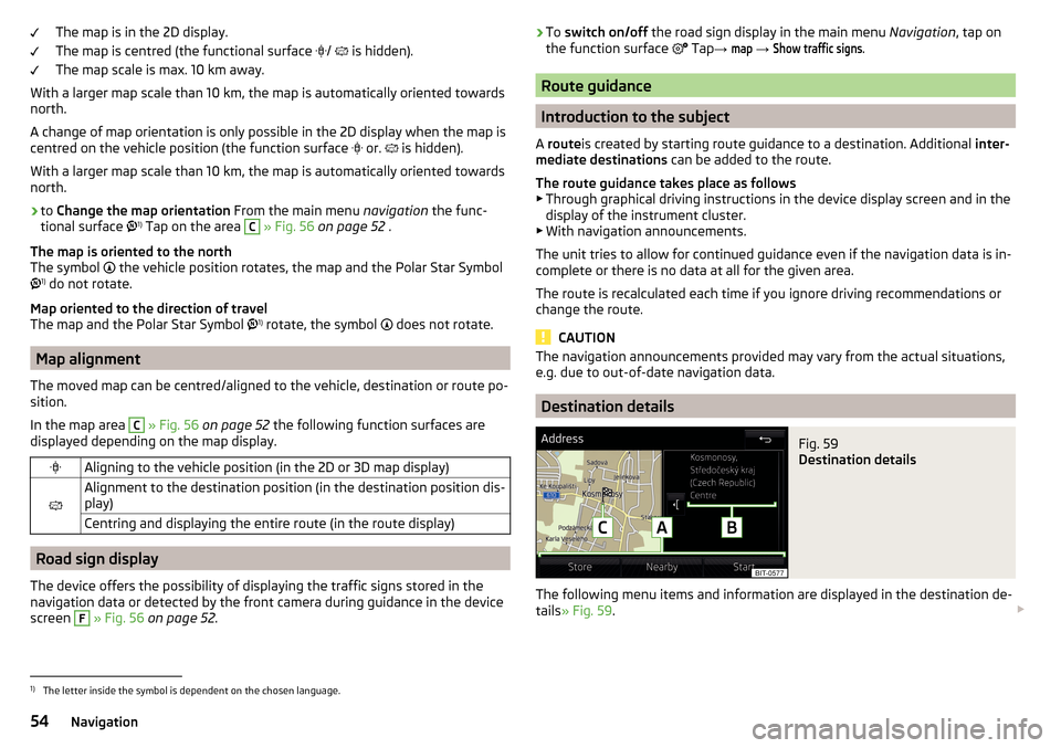
Destination details
Fig. 59
Destination details
The following menu items and information are displayed in the destination de-
tails » Fig. 59 .
1)
The letter inside the symbol is dependent on the chosen language.
54Navigation
Page 59 of 76
▶Within 15 min. - route guidance is continued taking into account the calcula-
ted route.
▶ Between 15 min and 120 min - the screen displays the message Continue routeguidance?
, after you confirm the message, the route guidance continues using
the calculated route.
▶ After 120 min - the route guidance is cancelled.
Route
Route plan
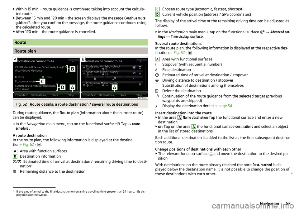
Fig. 62
Route details: a route destination / several route destinations
During route guidance, the Route plan (Information about the current route)
can be displayed.
›
In the Navigation main menu, tap on the functional surface
Tap
→
routeschedule
.
A route destination
In the route plan, the following information is displayed at the destina-
tion » Fig. 62 -
.
Area with function surfaces
Destination information Estimated time of arrival at destination / remaining driving time to desti-
nation 1)
Remaining distance to the destination
AB Chosen route type (economic, fastest, shortest)
Current vehicle position (address / GPS coordinates)
The display of the arrival time or the remaining driving time can be adjusted as
follows.
▶ In the Navigation main menu, tap on the functional surface
→ Advanced set-tings
→
Time display:
surface.
Several route destinations
In the route plan, the following information is displayed at the respective des- tinations » Fig. 62 -
.
Area with functional surfaces
Stopover (with sequential number)
Final destination
Estimated time of arrival at destination / stopover
Driving distance to destination / stopover
Substitution of destinations among themselves
Delete the destination
Continuation of the route guidance from the selected target (previous
waypoints are skipped)
Display the destination details » page 54
Insert destination into the route ▶ In the area
A
Name destination
Tap the functional surface and enter a new
destination.
▶ or: Tap on the area
A
the functional surface
destinations
and select an object
in the list of stored destinations.
Each additional destination is added to the list as the first subsequent destina- tion route.
Change positions of destinations with each other
▶ The relevant function surface and move the destination to the desired po-
sition.
With destinations on the route already reached the note
Dest. reached
is dis-
played below the destination name. It is not possible to change the position of
these destinations with each other.
CDA1)
If the time of arrival to the final destination or remaining travelling time greater than 24 hours,
is dis-
played inside the symbol.
57Navigation
Page 62 of 76
■Suggest 3 alternative routes - Switch on/off the menu for alternative routes (eco-
nomical, fast, short)
■Route:
- Setting the preferred route
■
Most frequent routes
- Show/hide the menu of the most frequent routes in the
split screen
■
Dynamic route
- Switch on/off dynamic route recalculation due to TMC traffic
reports
■
Avoid motorway
Switch on/off the non-use of motorways in the route calcu-
lation
■
Avoid ferries and motorail trains
- Switch on/off the non-use of ferries and mo-
torail trains in the route calculation
■
Avoid toll roads
- Switch on/off use of toll roads for the route calculation
■
Avoid tunnels
- Switch on/off use of tunnels for the route calculation
■
Avoid routes requiring toll stickers
- Switch use of routes requiring toll stickers
on/off for route calculation
■
Available toll stickers
- Selection of countries for which a valid toll sticker is re-
quired (routes requiring toll stickers are used for route calculation)
■
Consider trailer
- Turn on / off the setting to take a trailer into account for
route calculation » page 55
Map
›
In the Navigation main menu, tap on the functional surface
Tap on
→
map
.
■
Show road signs
- Switch on/off the display of traffic signs
■
Lane guidance
- Display of lane guidance on/off
■
Show favourites
- Switch on/off the display of favourites
■
Show POIs
- Switch on/off the display of POIs
■
Select Interest categories
- Selection of the displayed category POIs
■
Show brands for POIs
- Switch on/off the company logos available for the POIs
shown
Manage memory
›
In the Navigation main menu, tap on the functional surface
Tap on
→
Man-age memory
.
■
Sort Contacts:
- Setting the configuration of the phone book
■
Surname
- Sorting by the contact surname
■
By first name
- Sorting by the contact first name
■
Define home address
- Enter the home address
■
Delete My POIs
- Deleting own POI categories (Personal POI)
■Update My POIs (SD / USB) - Import / update your own POI categories (Personal
POI)
■Import objectives (SD / USB)
- Import destinations in vCard format
■
Delete User Data
- Delete user data (by pressing the function surface
Delete
and
confirm the deletion) ■
Last destinations
- Delete the last destinations
■
Dest. memory
- Delete the stored destinations
■
Routes
- Delete saved routes
■
My points of interest (Personal POI)
- Delete the custom POIs
■
Entered cities
- Delete the history of places already entered via the address
■
Home address
- Delete the stored home address
■
Flagged destination
- Delete the flagged destination
■
Most frequent routes
- Deletion of the most travelled routes
Navigation announcements
›
In the Navigation main menu, tap on the functional surface
Tap
→
naviga-tion announcements
.
■
Volume
- Volume control of the navigation announcements
■
Entertainment fading (nav. announce.)
- Setting the fading of the audio volume (e.g.
radio volume.) with navigation announcements
■
Nav. announcements:
Nav. announcements: - Sets the type of navigation an-
nouncements
■
Comprehensive
- All navigation announcements
■
Brief
- Short navigation announcements
■
Only in the event of issues
- Only navigation announcements when a route is
changed
■
No navigation sound during call
- Enable / disable the playback of navigation
prompts during a telephone conversation
Fuel options
›
In the Navigation main menu, tap on the functional surface
Tap
→
tank op-tions
.
■
Select preferred fuel station
- Select your preferred fuel station brand (the selec-
ted station brand will be displayed in the first three positions of the list)
■
Tank warning
-Turn on- / Off the display of a warning message with the option
to visit the nearest petrol station when the fuel level reaches the reserve
area
60Navigation
Page 65 of 76
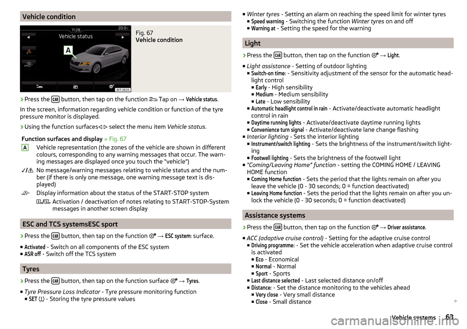
Vehicle conditionFig. 67
Vehicle condition
›
Press the button, then tap on the function
Tap on
→
Vehicle status
.
In the screen, information regarding vehicle condition or function of the tyre
pressure monitor is displayed.
›
Using the function surfaces
select the menu item
Vehicle status.
Function surfaces and display » Fig. 67AVehicle representation (the zones of the vehicle are shown in different
colours, corresponding to any warning messages that occur. The warn-
ing messages are displayed once you touch the “vehicle”) No message/warning messages relating to vehicle status and the num-
ber (if there is only one message, one warning message text is dis-
played)Display information about the status of the START-STOP system Activation / deactivation of notes relating to START-STOP-System
messages in another screen display
ESC and TCS systemsESC sport
›
Press the button, then tap on the function
→
ESC system:
surface.
■
Activated
- Switch on all components of the ESC system
■
ASR off
- Switch off the TCS system
Tyres
›
Press the button, then tap on the function surface
→
Tyres
.
■ Tyre Pressure Loss Indicator - Tyre pressure monitoring function
■
SET
- Storing the tyre pressure values
■
Winter tyres - Setting an alarm on reaching the speed limit for winter tyres
■Speed warning
- Switching the function Winter tyres on and off
■
Warning at
- Setting the speed for the warning
Light
›
Press the button, then tap on the function
→
Light
.
■ Light assistance - Setting of outdoor lighting
■
Switch-on time:
- Sensitivity adjustment of the sensor for the automatic head-
light control ■
Early
- High sensibility
■
Medium
- Medium sensibility
■
Late
- Low sensibility
■
Automatic headlight control in rain
- Activate/deactivate automatic headlight
control in rain
■
Daytime running lights
- Activate/deactivate daytime running lights
■
Convenience turn signal
- Activate/deactivate lane change flashing
■ Interior lighting - Sets the interior lighting
■
Instrument/switch lighting
- Sets the brightness of the instrument/switch light-
ing
■
Footwell lighting
- Sets the brightness of the footwell light
■ “Coming/Leaving Home” function - setting the COMING HOME / LEAVING
HOME function
■
Coming Home function
- Sets the period that the lights remain on after you
leave the vehicle (0 - 30 seconds; 0 = function deactivated)
■
Leaving Home function
- Sets the period that the lights remain on after you un-
lock the vehicle (0 - 30 seconds; 0 = function deactivated)
Assistance systems
›
Press the button, then tap on the function
→
Driver assistance
.
■ ACC (adaptive cruise control) - Setting for the adaptive cruise control
■
Driving programme:
- Set the vehicle acceleration when adaptive cruise control
is activated
■
Eco
- Economical
■
Normal
- Normal
■
Sport
- Sports
■
Last distance selected
- Last selected distance on/off
■
Distance:
- Set the distance monitoring to the vehicles ahead
■
Very close
- Very small distance
■
Close
- Small distance
63Vehicle systems
Page 66 of 76
■Medium - Medium distance
■Far
- Large distance
■
Very far
- Very large distance
■ Front Assist (ambient traffic monitor. sys.) - Set the assistant for distance
monitoring to the vehicles ahead ■
Active
- Activate/deactivate the assistant
■
Advance warning
- Activates/deactivates advance warning function
■
Display distance warning
- Activate/deactivate distance warnings
■ Driver Alert System - Activate/deactivate the driver alert system
Parking and manoeuvring
›
Press the button, then tap on the function
→
Parking and manoeuvring
.
■ ParkPilot - Settings for the parking aid
■
Activate automatically
- Activate/deactivate the compact parking aid display
(when driving forward)
■
Front volume
- Adjust the volume of the beeps for obstacle detection in front
■
Front tone setting
- Setting the pitch of the beeps for obstacle detection in
front
■
Rear volume
- Set the volume level of the beeps for the rear obstacle detec-
tion
■
Rear tone setting
- Setting the pitch of the beeps for the rear obstacle detec-
tion
■
Entertainment fading (parking)
- Lowers the audio volume (e.g. radio volume)
with activated parking aid
Windshield wipers
›
Press the button, then tap on the function
Tap
→
Windscreen wipers
.
■ Wipers - Adjusts the windscreen wipers
■
Automatic wiping in rain
- Activate/deactivate automatic windscreen wiping in
rain
■
Automatic rear wiper
- Activate/deactivate automatic rear window wiping
Open and close
›
Press the button, then tap on the function
→
Opening and closing
.
■
Central locking - Settings for opening and closing of doors
■Door unlocking:
- Set the door unlocking feature
■
All doors
- All doors
■
Single door
- Driver's or passenger's door (when unlocking via the sensor in
the passenger door handle)
■
Vehicle side
- Doors on the driver or passenger side (when unlocking via the
sensor in the passenger door handle)
■
Automatic locking
- Activate/deactivate automatic locking when starting off
Instrument cluster (multifunction display)
›
Press the button, then tap on the functional surface
→
Instrument cluster
.
In this menu it is possible to hide/show the appearance of the menu items in
the instrument cluster multifunction display and reset the trip data.
■
Current consumption
- Display of current fuel consumption on/off
■
Average consumption
- Display of average fuel consumption on/off
■
Travelling time
- Display of travelling time on/off
■
Distance travelled
- Display of distance travelled on/off
■
Average speed
- Display of average speed on/off
■
Digital speed display
- Display of current speed on/off
■
Speed warning
- Winter tyres warning on/off
■
Oil temperature
- Oil temperature on/off
■
Reset "Since start" driving data
- Reset the single-trip memory in the device
screen and in the display of the instrument cluster
■
Reset "Long-term" driving data
- Reset the long-term memory in the device screen
and in the display of the instrument cluster
Time, date and unit setting
›
Press the button, then tap the function surface
Time and date
.
›
Press the button, then tap the function surface
Units
.
Service
›
Press the button, then tap on the function
→
Service
.
■ Vehicle identification number: - Display of the vehicle identification number
(VIN)
■ Inspection in … or … days - number of km/days until the next inspection
■ Oil change service in ... or ... days - number of km/days until the next oil
change
64Vehicle systems
Page 71 of 76
Map60
Map alignment54
Map scale53
Most common routes56
My destinations51
Navigation announcements60
Navigation data46
Nav. announcements56
Options for map display53
Preferred type of route59
Route54
Route display53
Route guidance54
Route information57
Route memory58
Route options59
Route plan57
Settings59
Status line61
Traffic jam ahead59
Traffic reports (TMC)58
Trailer towing55
Voice control13
Navigation announcements60
Navigation data46
Nav. announcements56
Network set to
32
New route58
O
Oil change
64
Open64
Operation Media
22
MirrorLink®44
Radio19
Telephone31
Own POI categories51
P
Pairing process
33
Park Assist64
Parking64
Parking spot49
ParkPilot64
Personal POIs51
Petrol station logo60
Phone Additional phone
31
Adjust text messages32
Clear calls32
Connection types31
Diverting calls32
Import contacts32
Main phone31
Manage Favourites32
Premium32
Settings call32
set to32
User profile32
Voice control13
Phone connection types31
Pictures27
Compatible sources28
File formats28
Requirements and restrictions28
Supported file formats28
Pin code set to
32
Play Media
23
POI51
Choose in the map52
Import51
My POIs51
Speed dial49
Tap in the map52
Preferred contacts35
Principles of device operation11
R
radio Select station
19
Radio19
Broadcasting19
DAB settings21
FM - settings21
L-band22
List of available stations20
Main menu19
Operation19
Preface19
Radio station Logo20
Save station20
Scan19
Search stations19
set to21
Station buttons20
Traffic programme (TP)21
Voice control13
Radio station Logo
20
Radio station logos20
Update18
Radio stations Choose
19
Save station20
Search stations19
Select station19
Station buttons20
Rear window - automatic wiping64
Reset - vehicle settings65
Restart the device10
restaurant49
Road sign54
69Index
Page 74 of 76
Reprinting, duplicating, translating and any other use, either in whole or in
part, is not permitted without the written consent of ŠKODA AUTO a.s.
ŠKODA AUTO a.s. expressly reserves all rights relating to copyright laws.
Subject to change.Issued by: ŠKODA AUTO a.s.
© ŠKODA AUTO a.s. 2016