navigation system SUBARU BRZ 2017 1.G Navigation Manual
[x] Cancel search | Manufacturer: SUBARU, Model Year: 2017, Model line: BRZ, Model: SUBARU BRZ 2017 1.GPages: 334, PDF Size: 10.36 MB
Page 93 of 334
Navigation 91
Read First
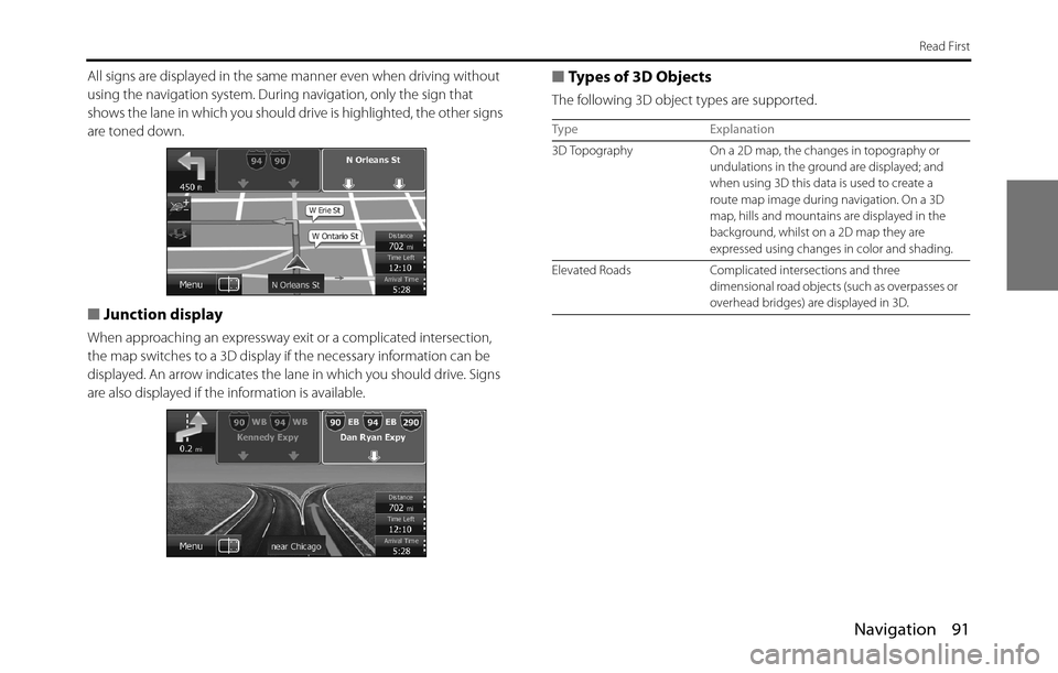
All signs are displayed in the same manner even when driving without
using the navigation system. During navigation, only the sign that
shows the lane in which you should drive is highlighted, the other signs
are toned down.
■Junction display
When approaching an expressway exit or a complicated intersection,
the map switches to a 3D display if the necessary information can be
displayed. An arrow indicates the lane in which you should drive. Signs
are also displayed if the information is available.
■Types of 3D Objects
The following 3D object types are supported.
Type Explanation
3D Topography On a 2D map, the changes in topography or
undulations in the ground are displayed; and
when using 3D this data is used to create a
route map image during navigation. On a 3D
map, hills and mountains are displayed in the
background, whilst on a 2D map they are
expressed using changes in color and shading.
Elevated Roads Complicated intersections and three
dimensional road objects (such as overpasses or
overhead bridges) are displayed in 3D.
Page 102 of 334
100 Navigation
Read First
Check Current Position (Where Am I?)
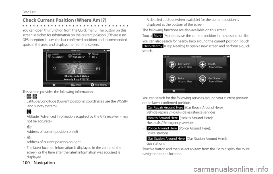
You can open this function from the Quick menu. The button on this
screen searches for information on the current position (if there is no
GPS reception it uses the last confirmed position) and recommended
spots in the area, and displays them on the screen.
This screen provides the following information.
•, :
Latitude/Longitude (Current positional coordinates use the WGS84
land survey system)
•:
Altitude (Advanced information acquired by the GPS receiver - may
not be accurate)
•:
Address of current position on left
•:
Address of current position on right
•The latest location information is displayed in the center of the
screen, or the time after the latest information was acquired is
displayed.•A detailed address (when available) for the current position is
displayed at the bottom of the screen.
The following functions are also available on this screen.
Touch (More) to save the current position in the destination list.
You can also search for nearby help around the current position. Touch
(Help Nearby) to open a new screen and perform a quick
search.
You can search for the following services around your current position
or the latest confirmed position.
• (Car Repair Around Here):
Vehicle repairs / Road-side assistance services
• (Health Around Here):
Hospitals / Emergency services
• (Police Around Here):
Police stations
• (Gas Station Around Here):
Gas stations
Touch a button and then select an item from the list to display the route
navigation to the location.
More
Help Nearby
Car Repair Around Here
Health Around Here
Police Around Here
Gas Station Around Here
Page 133 of 334
Navigation 131
Navigation
Selecting a Frequently Used Destination (Smart
History)
Destinations that have been set previously are displayed in the History
list. The two most recent destinations are displayed on the destination
menu allowing you to select them easily. Smart History uses conditions
such as the current time, date, and position, and displays a position in
response to the user's navigation habits. The more you use the
navigation system, the more accurate the anticipated destination
becomes.
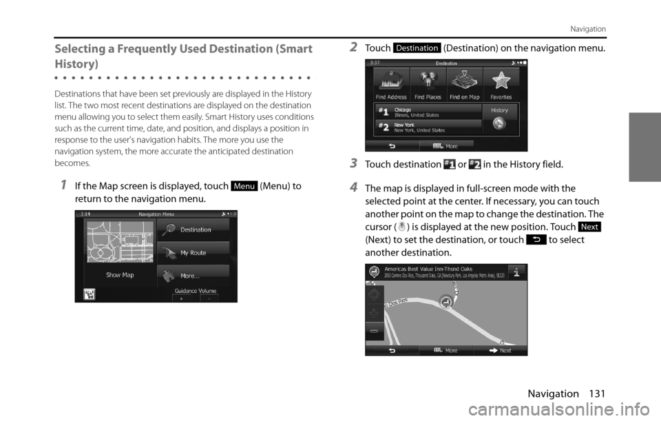
1If the Map screen is displayed, touch (Menu) to
return to the navigation menu.
2Touch (Destination) on the navigation menu.
3Touch destination or in the History field.
4The map is displayed in full-screen mode with the
selected point at the center. If necessary, you can touch
another point on the map to change the destination. The
cursor ( ) is displayed at the new position. Touch
(Next) to set the destination, or touch to select
another destination.Menu
Destination
Next
Page 151 of 334
Navigation 149
Navigation
Voice Control Navigation
By using the voice control system (voice input microphone
and button), you can set the destination by giving voice
commands. This enables you to use functions that are usually
inoperable while driving.
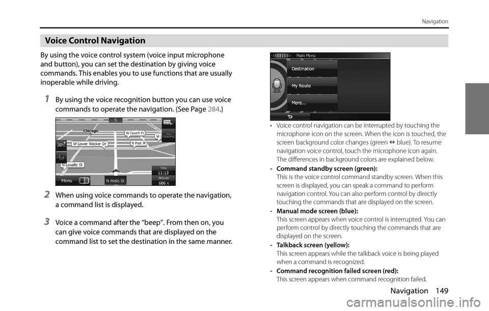
1By using the voice recognition button you can use voice
commands to operate the navigation. (See Page 284.)
2When using voice commands to operate the navigation,
a command list is displayed.
3Voice a command after the “beep”. From then on, you
can give voice commands that are displayed on the
command list to set the destination in the same manner.
• Voice control navigation can be interrupted by touching the
microphone icon on the screen. When the icon is touched, the
screen background color changes (green �Q blue). To resume
navigation voice control, touch the microphone icon again.
The differences in background colors are explained below.
- Command standby screen (green):
This is the voice control command standby screen. When this
screen is displayed, you can speak a command to perform
navigation control. You can also perform control by directly
touching the commands that are displayed on the screen.
- Manual mode screen (blue):
This screen appears when voice control is interrupted. You can
perform control by directly touching the commands that are
displayed on the screen.
- Talkback screen (yellow):
This screen appears while the talkback voice is being played
when a command is recognized.
- Command recognition failed screen (red):
This screen appears when command recognition failed.
Page 169 of 334
Navigation 167
Glossary
Route
The route is an ordered arrangement of the route events (the next
change in the route - right or left turns, roundabouts, and so on),
presenting them as they occur until you reach your destination. If there
is one starting point, there must be at least one destination. On startup,
the start point is the current position (or the last confirmed position). If
you need to check a route that is not currently being driven, you can
move the start point to wherever you want.
Heads-up Map Direction
Heads-up mode rotates the map so that the direction you are currently
traveling is always at the top of the map. This is the default direction in
3D map display mode. Also see “North Up Map Direction”.
Glossary
To enhance your enjoyment of this product, please familiarize yourself
with the following terms.
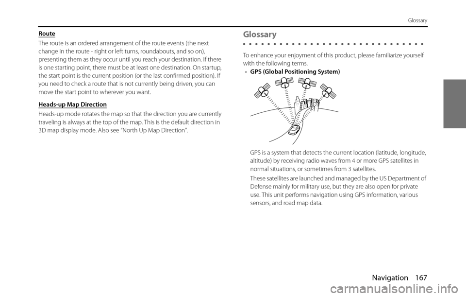
•GPS (Global Positioning System)
GPS is a system that detects the current location (latitude, longitude,
altitude) by receiving radio waves from 4 or more GPS satellites in
normal situations, or sometimes from 3 satellites.
These satellites are launched and managed by the US Department of
Defense mainly for military use, but they are also open for private
use. This unit performs navigation using GPS information, various
sensors, and road map data.
Page 173 of 334
Navigation 171
End-user License Agreement
7 Limitations of use
7.1 The User is not entitled
7.1.1 to duplicate the Software Product (to make a copy thereof );
7.1.2 to lease, rent or lend it or to transfer it to a third person for any reason;
7.1.3 to translate the Software Product (including translation (compilation)
to other programing languages);
7.1.4 to decompile the Software Product;
7.1.5 to evade the protection of the Software Product or to modify,
circumvent or obviate such protection through technological or by
any other means;
7.1.6 to modify, extend, transform the Software Product (in whole or in
part), to separate it into parts, combine it with other products, install it
in other products, utilise it in other products, not even for the purpose
of achieving interoperability with other devices;
7.1.7 apart from using the computer program, to obtain information from
the Database as a part of the Software Product, to decompile the
Database, to use, copy, modify, extend, transform the Database in
whole or in part or the group of data stored therein, or to install it in
other products or otherwise, utilise it in other products or to transfer
it, not even with the aim of achieving interoperability with other
products.
7.2 The User may only use the contents available through the Software
Product and provided by third parties and the data received through
the services provided by third parties (including but not limited to the
traffic data received from the RDS TMC traffic information service) for
his/her own personal benefit and at his/her own risk. It is strictly
prohibited to store, to transfer or to distribute these data or contents
or to disclose them in full or in part to the public in any format or to
download them from the product.8 No warranty, limitation of liability
8.1 The Licensor hereby informs the User that although the greatest care
was taken in producing the Software Product, given the nature of the
Software Product and its technical limitations, the Licensor does not
provide a warranty for the Software Product being completely error-
free, and the Licensor is not bound by any contractual obligation
whereby the Software Product obtained by the User should be
completely error-free.
8.2 The Licensor does not warrant that the Software Product is suitable
for any purpose defined either by the Licensor or the User, and does
not warrant that the Software Product is capable of interoperating
with any other system, device or product (e.g. software or hardware).
8.3 The Licensor does not assume any responsibility for damages
incurred due to an error in the Software Product (including errors of
the computer program, the documentation and the Database).
8.4 The Licensor does not assume any responsibility for damages
incurred due to the Software Product not being applicable for any
defined purpose, or due to the error or incompatibility of the
Software Product with any other system, device or product (e.g.
software or hardware).
8.5 The Licensor also draws the attention of the User to the fact that,
when using the Software Product in any form of vehicle, observing
the traffic regulations and rules (e.g. use of obligatory and/or
reasonable and suitable security measures, proper and generally
expected care and attention in the given situation, and special care
and attention required due to the use of the Software Product) is the
exclusive responsibility of the User. The Licensor shall not assume any
responsibility for any damages occurred in relation to use of the
Software Product in a motor vehicle.
8.6 By concluding the Agreement, the User shall, in particular,
acknowledge the information stated in Section 8 above.
Page 176 of 334
174 Navigation
Further Information
Display Connection Status Information
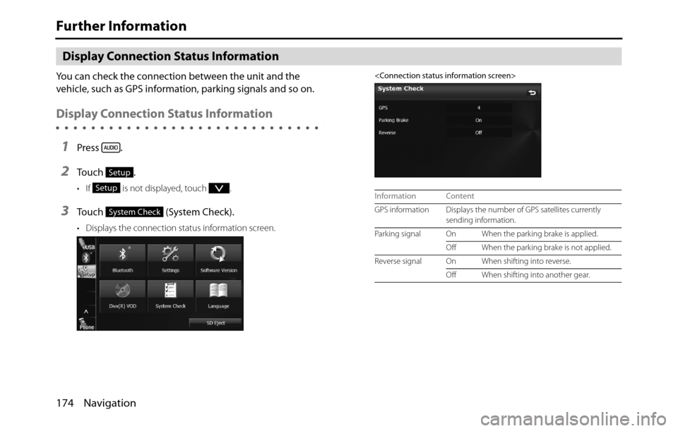
You can check the connection between the unit and the
vehicle, such as GPS information, parking signals and so on.
Display Connection Status Information
1Press .
2To u c h .
• If is not displayed, touch .
3Touch (System Check).
• Displays the connection status information screen.
Setup
Setup
System Check
Information Content
GPS information Displays the number of GPS satellites currently
sending information.
Parking signal On When the parking brake is applied.
Off When the parking brake is not applied.
Reverse signal On When shifting into reverse.
Off When shifting into another gear.
Page 178 of 334
176 Navigation
Further Information
NOTE•Because the GPS satellite is in orbit around the earth, the reception status for
the electromagnetic waves changes depending on their position at that point
in time, even if your vehicle is in the same place. Also, electromagnetic-waves
from satellites near the horizon can be easily influenced by surrounding
obstacles.
•At times, satellites under the control of the US Department of Defence will
intentionally drop positioning accuracy.
Regarding Errors in Current Position Display
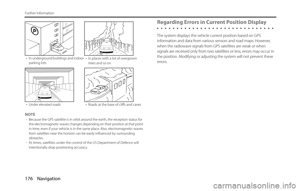
The system displays the vehicle current position based on GPS
information and data from various sensors and road maps. However,
when the radiowave signals from GPS satellites are weak or when
signals are received only from two satellites or less, errors may occur in
the position. Modifying or adjusting the system will not prevent these
errors.
• In underground buildings and indoor
parking lots• In places with a lot of overgrown
trees and so on
• Under elevated roads • Roads at the base of cliffs and caves
Page 181 of 334
Navigation 179
Further Information
Regarding Roads and Place Name Data
Because road and place names may change after the map data has
been created, there may be times when road and place names do not
match.
When no information is available in the map data, function such as
display of road names, searching for facilities, and route guidance
cannot be used.
When maps are created, land surveys are conducted and information
about roads improvement and opening is collected to provide the
most accurate information possible. However, modifications in roads,
place names and facilities may be carried out at any time.
Consequently, we cannot guarantee that map data contains no errors
in road positions, configuration and names, or in facility names.
The navigation system includes a function to read out names of roads,
intersections, and so on during guidance.
Depending on the selected language, names read out by the system
may not be exactly accurate due to missing information in map data.
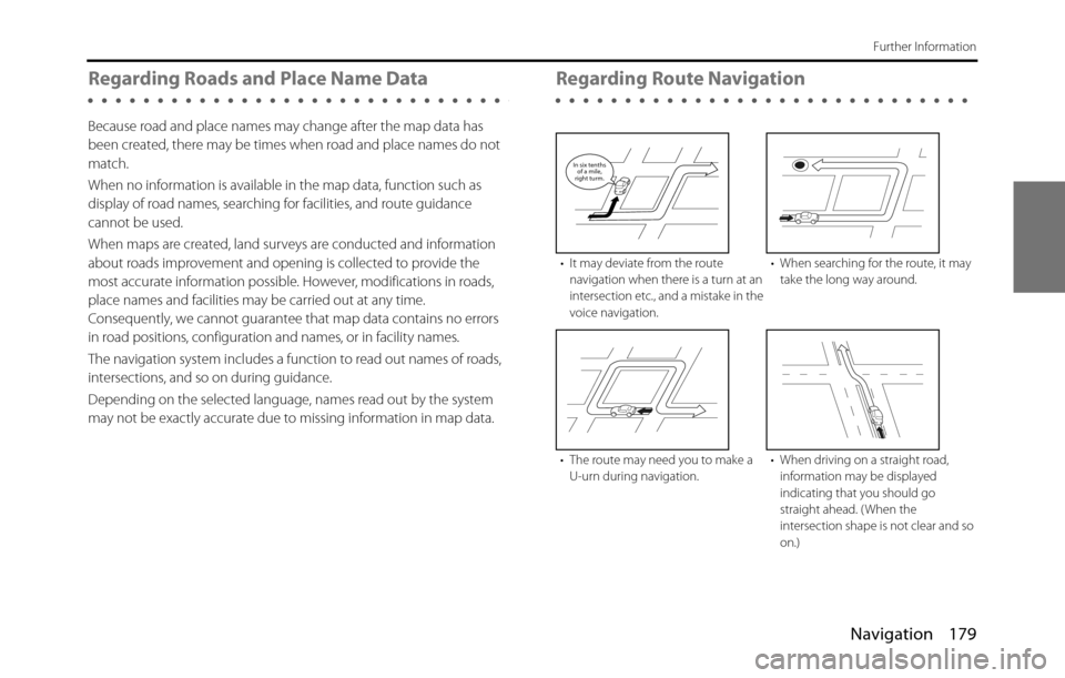
Regarding Route Navigation
• It may deviate from the route
navigation when there is a turn at an
intersection etc., and a mistake in the
voice navigation.• When searching for the route, it may
take the long way around.
• The route may need you to make a
U-urn during navigation.• When driving on a straight road,
information may be displayed
indicating that you should go
straight ahead. ( When the
intersection shape is not clear and so
on.)
In six tenths
of a mile,
right turm.
Page 268 of 334
266 Audio and Visual
How to Operate Portable Audio Devices
Using Aha�¥ by HARMAN
About Aha
Aha is a cloud-based app that connects to your car and gives you
access to your favorite web content safely and easily. There are over
30,000 stations spanning internet radio, personalized music,
audiobooks, Facebook, Twitter, restaurant and hotel searches, weather
and more.
For more about Aha, go to aharadio.com.
When connecting iPhone and iPod touch or Android devices with the
Aha application installed, you can control, view, and hear Aha content
through the navigation system in this vehicle. You may be also display
POI information from the Aha application on the navigation system
map screen and route to these POIs.
The following devices can use this function.
•iPhone and iPod touch
•Android�¥ devices
In this chapter, iPhone and iPod touch or Android devices will be
referred to as a smartphone.
WA R N I N G
•For safety reasons, certain functions are not available while
your vehicle is in motion.
•Do not connect or operate the smartphone while driving.
•Be sure to park the vehicle in a safe location before
connecting or operating the smartphone.
CAUTION
• Certain functions (such as touch panel operation and/or
video image) offered by this unit may not be used while
driving.
•Be careful not to exceed the data usage limits for your
smartphone. Doing so will result in additional data usage
charges from your phone carrier.
•If you lose the data in a smartphone or other device while
using it with this unit, no compensation will be given for the
lost data.
•Do not leave smartphone devices inside the vehicle. The
temperature inside the vehicle can often rise to a very high
level in hot weather and it may result in a malfunction of the
device.
•Do not put your weight on the connected smartphone or
put anything on it. Damage could result.
•Never insert any objects other than iPhone/iPod touch
connection cables into the connection slot on the iPhone/
iPod touch. Damage could result.
•In order to maximize signal reception, performance and
precision of the smartphone, please ensure the smartphone
is placed as close to the navigation unit as possible, while
ensuring it is stowed and secure while driving. Never
attempt to operate your smartphone device directly while
driving.