lock SUBARU FORESTER 2010 SH / 3.G Navigation Manual
[x] Cancel search | Manufacturer: SUBARU, Model Year: 2010, Model line: FORESTER, Model: SUBARU FORESTER 2010 SH / 3.GPages: 84, PDF Size: 2.33 MB
Page 7 of 84

Navigation 17
Starting Up the Navigation System
NOTE
•To make a selection, touch the desired key displayed on the screen.
•The CAUTION screen remains on the display unless you select .
•When you use the navigation system for the first time, Eastern Standard Time
(EST ) will be displayed. Adjust the system's clock to the right time using the
clock setting screen ("SET CLOCK") as described on Page 66.
Page 12 of 84

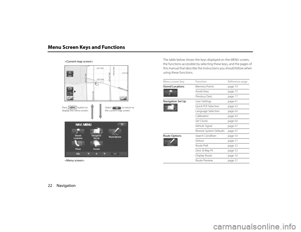
22 NavigationMenu Screen Keys and Functions
The table below shows the keys displayed on the MENU screen,
the functions accessible by selecting these keys, and the pages of
this manual that describe the instructions you should follow when
using these functions.
Select to return to
the current map screen.
Page 51 of 84

Navigation 61
Navigation Setup
(user settings):
This function allows you to change the screen display and sound
settings. (See Page 61.)
(quick POI selection):
This function allows you to set the point of interest categories that
are displayed when you select the menu from the current position
screen. (See Page 63.)
(language):
This function allows you to change the language for the menu
screens and the voice guidance. (See Page 64.)
(calibration):
You can use this function to correct display errors in the vehicle's
position and direction. (See Page 64.)
(set clock):
This function allows you to set the time. (See Page 66.)
(Vehicle Signal):
This function allows you to confirm the vehicle signal, the version
of the DVD-ROM disc. (See Page 67.)
(restore system defaults):
This function allows you to change the system's current settings
back to the default settings (factory settings). (See Page 67.)
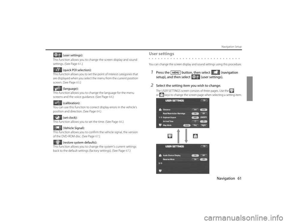
User settingsYou can change the screen display and sound settings using this procedure.1
Press the button, then select (navigation
setup), and then select (user settings).
2
Select the setting item you wish to change.The USER SETTINGS screen consists of three pages. Use the
or keys to change the screen page when selecting a setting item.
Page 52 of 84

62 NavigationNavigation Setup
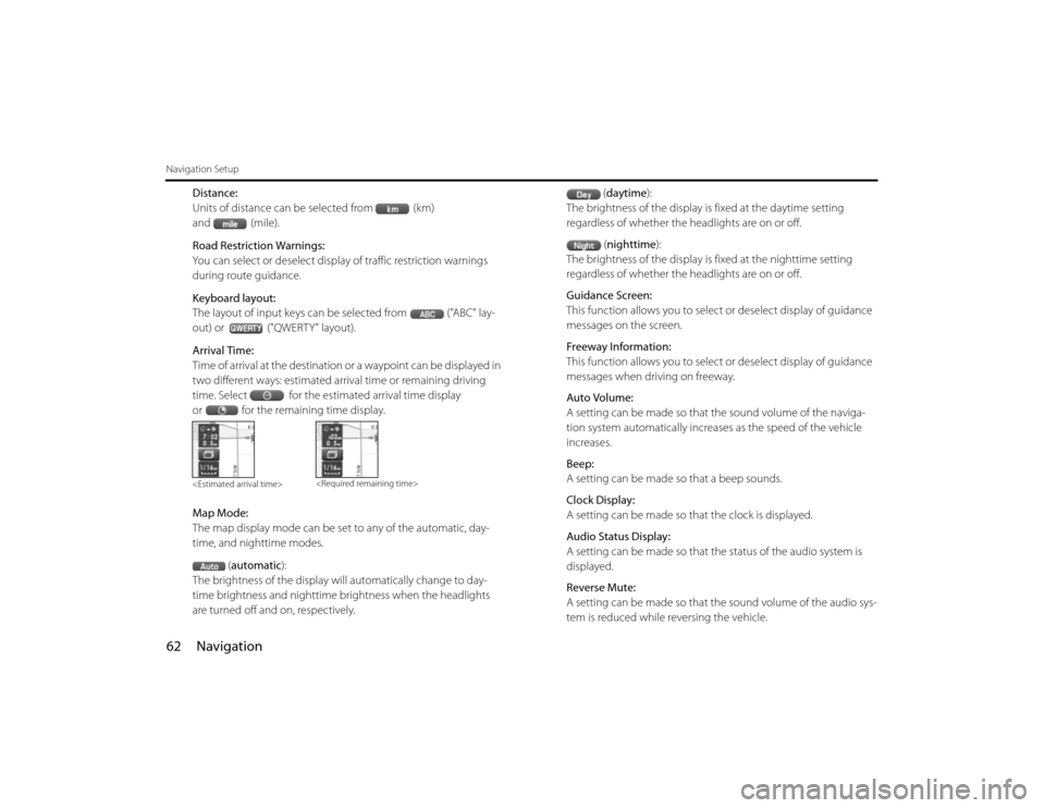
Distance:
Units of distance can be selected from (km)
and (mile).
Road Restriction Warnings:
You can select or deselect display of traffic restriction warnings
during route guidance.
Keyboard layout:
The layout of input keys can be selected from ("ABC" lay-
out) or ("QWERTY" layout).
Arrival Time:
Time of arrival at the destination or a waypoint can be displayed in
two different ways: estimated arrival time or remaining driving
time. Select for the estimated arrival time display
or for the remaining time display.
Map Mode:
The map display mode can be set to any of the automatic, day-
time, and nighttime modes.
(automatic):
The brightness of the display will automatically change to day-
time brightness and nighttime brightness when the headlights
are turned off and on, respectively.(daytime):
The brightness of the display is fixed at the daytime setting
regardless of whether the headlights are on or off.
(nighttime):
The brightness of the display is fixed at the nighttime setting
regardless of whether the headlights are on or off.
Guidance Screen:
This function allows you to select or deselect display of guidance
messages on the screen.
Freeway Information:
This function allows you to select or deselect display of guidance
messages when driving on freeway.
Auto Volume:
A setting can be made so that the sound volume of the naviga-
tion system automatically increases as the speed of the vehicle
increases.
Beep:
A setting can be made so that a beep sounds.
Clock Display:
A setting can be made so that the clock is displayed.
Audio Status Display:
A setting can be made so that the status of the audio system is
displayed.
Reverse Mute:
A setting can be made so that the sound volume of the audio sys-
tem is reduced while reversing the vehicle.
Page 56 of 84

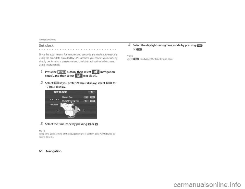
66 NavigationNavigation SetupSet clockSince the adjustments for minutes and seconds are made automatically
using the time data provided by GPS satellites, you can set your clock by
simply performing a time-zone and daylight saving time adjustment
using this function.1
Press the button, then select (navigation
setup), and then select (set clock).
2
Select if you prefer 24-hour display; select for
12-hour display.
3
Select the time-zone by pressing or .
NOTE
Initial time-zone setting of this navigation unit is Eastern (Disc A)/Mid (Disc B)/
Pacific (Disc C).
4
Select the daylight saving time mode by pressing
or .
NOTE
Select to advance the time by one hour.
Page 80 of 84

90 NavigationGeneral Information■Accuracy of vehicle positionArea in which GPS signals cannot be receivedBecause the radiowave signals from the GPS satellites travel primarily
by line of sight, the navigation system might not be able to receive
the signals in the areas described below.(If the GPS mark does not
appear on the map screen, it means that the GPS radiowave signals
are not being properly received.)
(1) Inside a tunnel
(2) Inside a building
(3) Under a three-dimensional road system such as for high speed
roads
(4) On boulevards lined with trees
(5) Between buildings
(6) Under a cliff or in a cave
•If the GPS antenna or its surroundings are blocked by an obstacle
(including cargo), it might not be possible for the system to
receive the GPS radiowave signals.
•If multiple paths are created due to the reflection from buildings,
a large measurement error could occur, causing the vehicle's
mark to deviate from its actual position.
Deviation of the vehicle's position markThe vehicle's position mark could deviate from its actual position
when the vehicle is being driven under the conditions listed below or
due to conditions of the GPS satellites.
If the vehicle travels on a road whose actual shape differs from that in
the map data, the vehicle's mark could deviate from the actual posi-tion. The correct position will eventually appear on the screen
through the correction function. If the screen does not show the cor-
rect position for an excessively long time, correct the current position
or make an automatic correction.
(1) The vehicle's mark could appear on a parallel road.
(2) When the road splits into a narrow Y, the vehicle's mark could
appear on the other fork of the Y.
(3) When the vehicle makes a right or left turn, the vehicle's mark
could appear on one street ahead or behind.
(4) If the vehicle is transported by means other than the vehicle's
own power, such as on a ferryboat, the vehicle's mark will
remain in the position it was before the transport until the sys-
tem can calculate the position through the GPS.
(5) When the vehicle is driven on a steep incline, the vehicle's mark
could deviate from its actual position.
(6) If there are continuous gradual curves in the same direction, the
vehicle's mark could deviate from its actual position.
(7) If the vehicle is driven in a zigzag pattern, such as through fre-
quent lane changes, the vehicle's mark could deviate from its
actual position.
(8) If the vehicle is placed on a turntable, such as in a parking area,
and turned with the ignition OFF, the vehicle's mark could devi-
ate from its actual orientation. The vehicle's mark could also
deviate even after the vehicle has exited the parking area.
(9) The vehicle's mark could deviate from its actual position if the
vehicle is driven using tire chains or snow tires on a snow-cov-
ered road or on a mountainous road.