sat nav SUBARU FORESTER 2014 SJ / 4.G Navigation Manual
[x] Cancel search | Manufacturer: SUBARU, Model Year: 2014, Model line: FORESTER, Model: SUBARU FORESTER 2014 SJ / 4.GPages: 106, PDF Size: 12.48 MB
Page 94 of 106
168 Navigation
Glossary
•Wide area map, detailed map
The wide area map is a map of a la rge area, and the detailed map is a
map of a small area. The scales of the maps are 1/20,480,000,
1/10,240,000, 1/5,120,000, 1/ 2, 560,000, 1/1,280,000, 1/640,000,
1/320,000, 1/160,000, 1/80,000, 1/40,000, 1/20,000, 1/10,000, and
1/5,000.
• Positioning
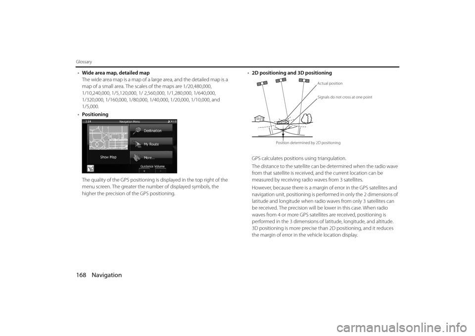
The quality of the GPS positioning is displayed in the top right of the
menu screen. The greater the number of displayed symbols, the
higher the precision of the GPS positioning. •
2D positioning and 3D positioning
GPS calculates positions using triangulation.
The distance to the satellite can be determined when the radio wave
from that satellite is received, and the current location can be
measured by receiving radio waves from 3 satellites.
However, because there is a margin of error in the GPS satellites and
navigation unit, positioning is performed in only the 2 dimensions of
latitude and longitude when radio waves from only 3 satellites can
be received. The precision will be lower in this case. When radio
waves from 4 or more GPS satellites are received, positioning is
performed in the 3 dimensions of la titude, longitude, and altitude.
3D positioning is more precise than 2D positioning, and it reduces
the margin of error in the vehicle location display.
Actual position
Signals do not cross at one point
Position determined by 2D positioning
Page 96 of 106
170 Navigation
End-user License Agreement
5 Rights under copyright
5.1 Unless otherwise provided by law or contractual provisions, the Licensor is the sole and exclusive owner of all material copyrights
vested in the Software Product.
5.2 Copyrights extend to the whole Software Product and to its parts separately as well.
5.3 The owner(s) of the copyrights of the Database forming part of the
Software Product is (are) the natura l person(s) or corporate entity(ies)
listed in the Appendix to this Agr eement or in the “About” menu item
of the operating computer progra m (hereinafter referred to as
Database Owner). The user's manual of the Software Product includes
the name of the menu option wher e all the owners of the Database
items are listed. The Licensor here by states that it has obtained
sufficient usage and representation rights from the Database owners
in order to utilise the Database, to of fer it for utilisation and to transfer
it for utilisation as set forth in this Agreement.
5.4 Pursuant to this Agreement, all ri ghts vested in the Software Product
shall remain in the ownership of the Licensor, except for those to
which the User is entitled under la w or by virtue of this Agreement. 6 Rights of the User
6.1 The User is entitled to install th
e Software Product into one hardware
device (desktop, handheld, portable computer, navigation device),
and to run and use one copy of the Software Product or a preinstalled
copy of the Software Product thereon.
6.2 The User is entitled to make one backup copy of the Software
Product. However, if the Software Pr oduct operates after installation
without the use of the original me dia copy, then the original media
copy shall be deemed to be a backup copy. In all other cases, the User
is only entitled to use the backup copy if the original media copy of
the Software Product has been ascertainably and unequivocally
rendered unsuitable for its lawful and intended use.
Page 98 of 106
172 Navigation
End-user License Agreement
9Sanctions
9.1 The Licensor hereby informs the User that, if the Licensor finds its rights under the Copyright Act to be breached, the Licensor may
9.1.1 seek judicial recogn ition of this breach;
9.1.2 demand that the breach cease and order the person in breach to refrain from continuing such actions;
9.1.3 demand that the person under breach give proper compensation
(even by way of publicity at the expense of the person in breach);
9.1.4 claim the return of the increa se of assets due to the breach;
9.1.5 demand the cease of the wrongful action and, demand restitution to
its state before the breach was committed at the expense of the
person in breach, and may demand the destruction of instruments
and materials used to commit the breach as well as of the products
created by the breach;
9.1.6 claim for damages.
9.2 The Licensor hereby also info rms the User that the breach of
copyrights and related rights is a crime under Act IV of 1978 on the
Hungarian Criminal Code, which ma y be sentenced of two years in
prison in basic cases and up to ei ght years in prison in aggravated
cases. 9.3 Contents and services provided by third parties
The Licensor hereby excludes any li ability of its own for the Database
in the Software Product and for any content or service provided by a
third party by using the Database. The Licensor does not warrant the
quality, suitability, accuracy, fitness for a specific purpose or territorial
coverage of the product or service or the availability of the service,
and it specifically excludes any li ability for the suspension of the
service, and any damage arising in relation to the service or for
complete cancellation of the service.
The User hereby acknowledges that the contents and services
provided by third parties may only be used at the risk of the User and
for the personal benefit of the User.
9.4 The parties hereby agree that the co urts of the Republic of Hungary will
have exclusive jurisdiction to rule on any disputes arising in connection
with this Agreement.
Page 100 of 106
174 Navigation
Further Information
Display Connection Status Information
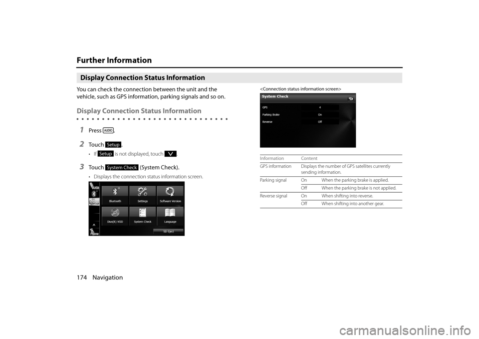
You can check the connection between the unit and the
vehicle, such as GPS information, parking signals and so on.
Display Connection Status Information
1Press .
2To u c h .
• If is not displayed, touch .
3To u c h ( S y s t e m C h e c k ) .
• Displays the connection status information screen.
Setup
Setup
System Check
Information Content
GPS information Displays the number of GPS satellites currently
sending information.
Parking signal On When the parking brake is applied.
Off When the parking brake is not applied.
Reverse signal On When shifting into reverse. Off When shifting into another gear.
Page 101 of 106
Navigation 175
Further Information
Accuracy & error calculation
Regarding Precision Accuracy
Since the GPS satellites are controlled by the US Depar tment of Defense
they do have a very high level of accuracy, however a multipath due to
reflections from buildings and so on could cause errors to occur.
Regarding the Properties of the GPS Electro-
Magnetic Waves and Signal Reception
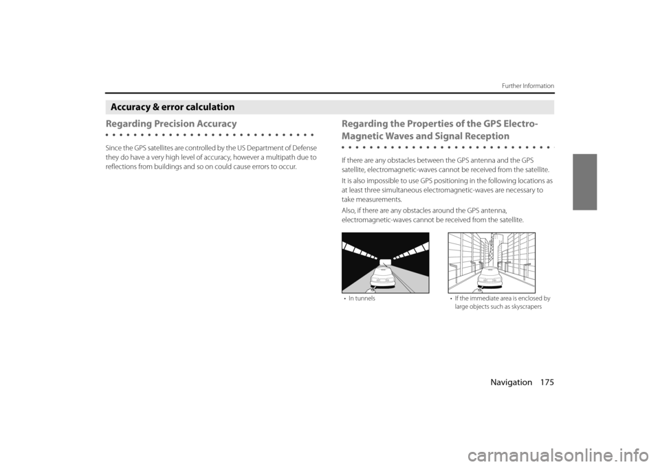
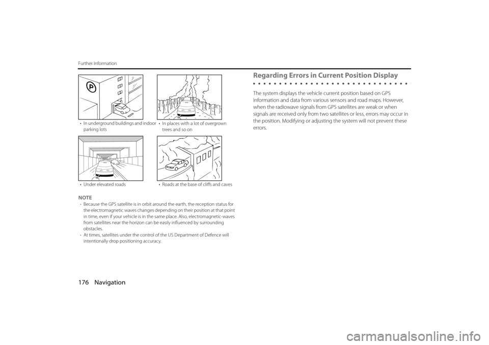
If there are any obstacles between the GPS antenna and the GPS
satellite, electromagnetic-waves cannot be received from the satellite.
It is also impossible to use GPS posi tioning in the following locations as
at least three simultaneous electr omagnetic-waves are necessary to
take measurements.
Also, if there are any obstacles around the GPS antenna,
electromagnetic-waves cannot be received from the satellite.
• In tunnels • If the immediate area is enclosed by
large objects such as skyscrapers
Page 102 of 106
176 Navigation
Further Information
NOTE•Because the GPS satellite is in orbit around the earth, the reception status for
the electromagnetic waves changes depend ing on their position at that point
in time, even if your vehicle is in th e same place. Also, electromagnetic-waves
from satellites near the horizon can be easily influenced by surrounding
obstacles.
• At times, satellites under the control of the US Department of Defence will
intentionally drop positioning accuracy.
Regarding Errors in Current Position Display
The system displays the vehicle current position based on GPS
information and data from various sensors and road maps. However,
when the radiowave signals from GPS satellites are weak or when
signals are received only from two sate llites or less, errors may occur in
the position. Modifying or adjusting the system will not prevent these
errors.
• In underground buil dings and indoor
parking lots • In places with a lot of overgrown
trees and so on
• Under elevated roads • Roads at the base of cliffs and caves
Page 103 of 106
Navigation 177
Further Information
Regarding Vehicle Position Detection
Correction Using Map Matching
Map matching is a method of comparing information on the current
position acquired by GPS and so on, with the road driven up to that
point, and correcting the current po sition based on the most likely
road.
This unit uses information on th e current position combined with
independent navigation and satellite navigation and matches it to the
shape of the road to create the correction.
However, as it cannot avoid the error margins at the current position,
the current position may shift away from the actual position even when
correcting using map matching.
Also, the vehicle marker may shift if the map data and the shape of the
road being driven on differ.
NOTE
Because it takes a short time for operations to stabilize just after turning on the
unit, the vehicle mark may not immediately match the vehicle as it moves. After
driving for a while, operations stabilize, and the marker should match the actual
driving position.
Regarding the Accuracy of the Current Position
and Route Navigation
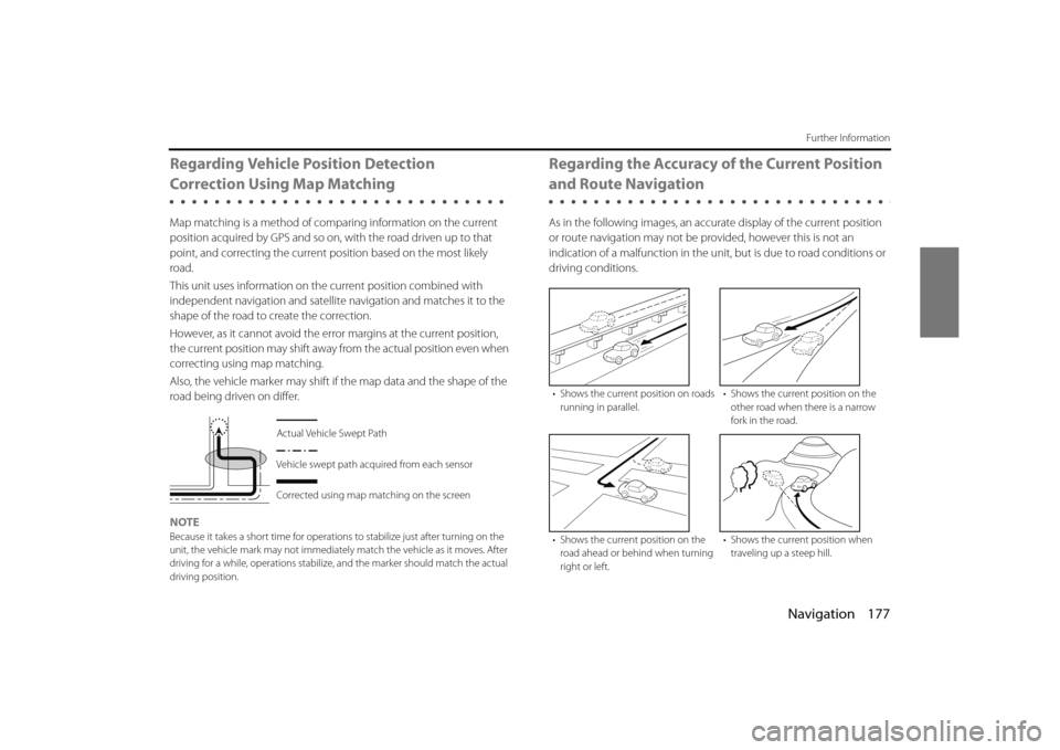
As in the following images, an accura te display of the current position
or route navigation may not be pr ovided, however this is not an
indication of a malfunction in the un it, but is due to road conditions or
driving conditions.
Actual Vehicle Swept Path
Vehicle swept path acquired from each sensor
Corrected using map matching on the screen
• Shows the current position on roads
running in parallel. • Shows the current position on the
other road when there is a narrow
fork in the road.
• Shows the current position on the road ahead or behi nd when turning
right or left. • Shows the current position when
traveling up a steep hill.