change time TOYOTA VENZA 2013 Accessories, Audio & Navigation (in English)
[x] Cancel search | Manufacturer: TOYOTA, Model Year: 2013, Model line: VENZA, Model: TOYOTA VENZA 2013Pages: 228, PDF Size: 3.73 MB
Page 2 of 228

2
1. BASIC INFORMATION BEFORE OPERATION
Introduction
This manual explains the operation of the Display Audio system. Please read
this manual carefully to ensure proper use. Keep this manual in your vehicle at
all times.
The screen shots in this document and the actual screens of the Display Audio
system differ depending on whether the functions and/or a contract existed and
the map data available at the time of producing this document.
The Navigation System is one of the most technologically advanced vehicle ac-
cessories ever developed. The system receives satellite signals from the Global
Positioning System (GPS) operated by the U.S. Department of Defense. Using
these signals and other vehicle sensors, the system indicates your present po-
sition and assists in locating a desired destination.
The navigation system is designed to select efficient routes from your present
starting location to your destination. The system is also designed to direct you
to a destination that is unfamiliar to you in an efficient manner. The system is
developed by “Harman International” us ing “Navteq” maps. The calculated
routes may not be the shortest nor the least traffic congested. Your own person-
al local knowledge or “short cut” may at times be faster than the calculated
routes.
The navigation system’s database includes Point of Interest categories to allow
you to easily select destinations such as restaurants and hotels. If a d\
estination
is not in the database, you can enter the street address or a major intersection
close to it and the system will guide you there.
The system will provide both a visual map and audio instructions. The audio in-
structions will announce the distance remaining and the direction to turn in ap-
proaching an intersection. These voice instructions will help you keep your eyes
on the road and are timed to provide enough time to allow you to maneuver,
change lanes or slow down.
Please be aware that all current vehicle navigation systems have certain limita-
tions that may affect their ability to perform properly. The accuracy of the vehi-
cle’s position depends on the satellite condition, road configuration, vehicle
condition or other circumstances. For more information on the limitations of the
system, refer to page 66.
DISPLAY AUDIO SYSTEM OWNER’S MANUAL
NAVIGATION SYSTEM
Page 15 of 228
15
1. CONTROLS AND FEATURES
1
QUICK GUIDE
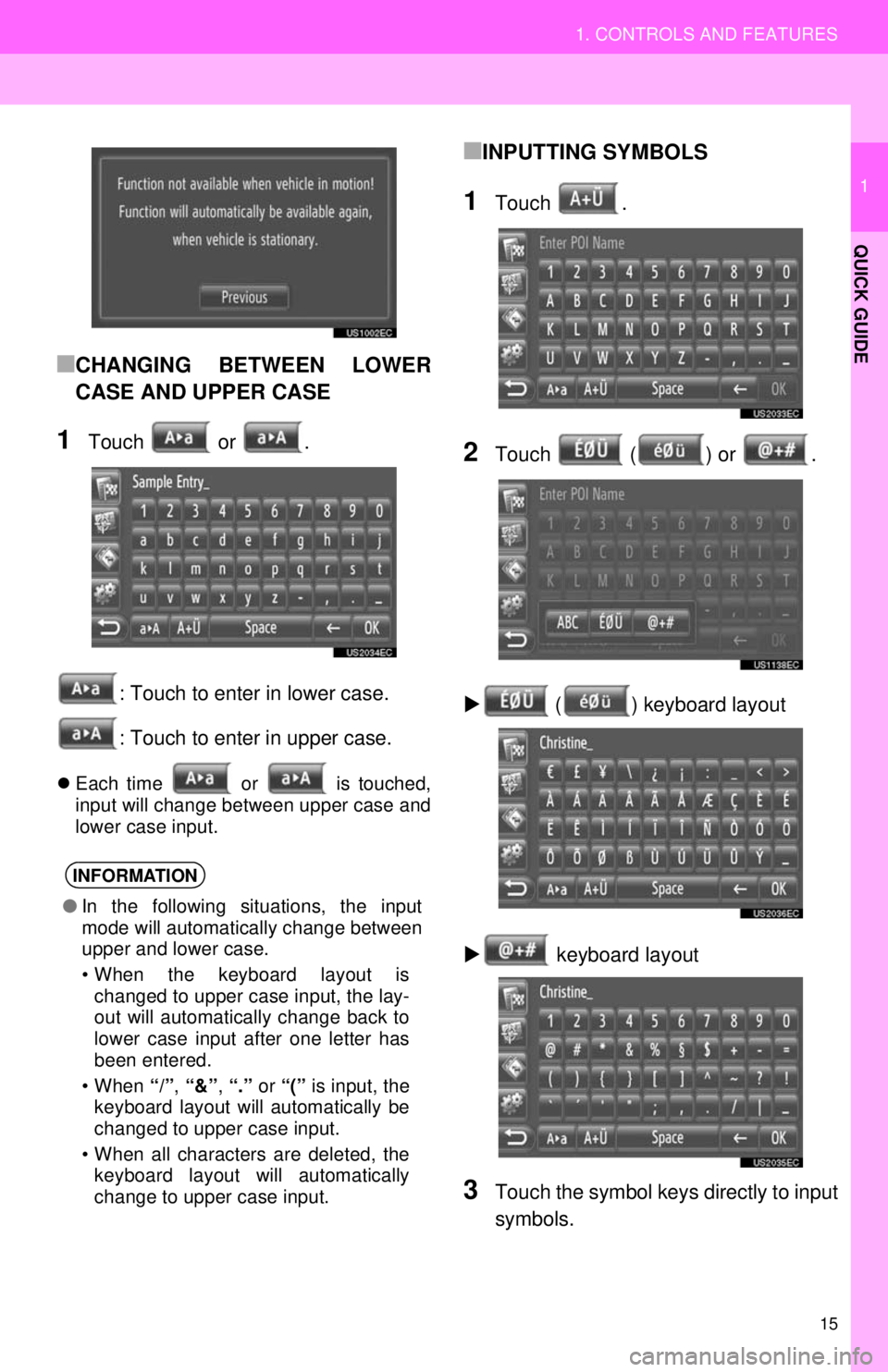
■CHANGING BETWEEN LOWER
CASE AND UPPER CASE
1Touch or .: Touch to enter in lower case.
: Touch to enter in upper case.
Each time or is touched,
input will change between upper case and
lower case input.
■INPUTTING SYMBOLS
1Touch .
2Touch ( ) or .
( ) keyboard layout
keyboard layout
3Touch the symbol keys directly to input
symbols.
INFORMATION
● In the following situations, the input
mode will automatically change between
upper and lower case.
• When the keyboard layout is
changed to upper case input, the lay-
out will automatically change back to
lower case input after one letter has
been entered.
• When “/”, “&” , “.” or “(” is input, the
keyboard layout will automatically be
changed to upper case input.
• When all characters are deleted, the keyboard layout will automatically
change to upper case input.
Page 22 of 228
22
1. NAVIGATION OPERATION
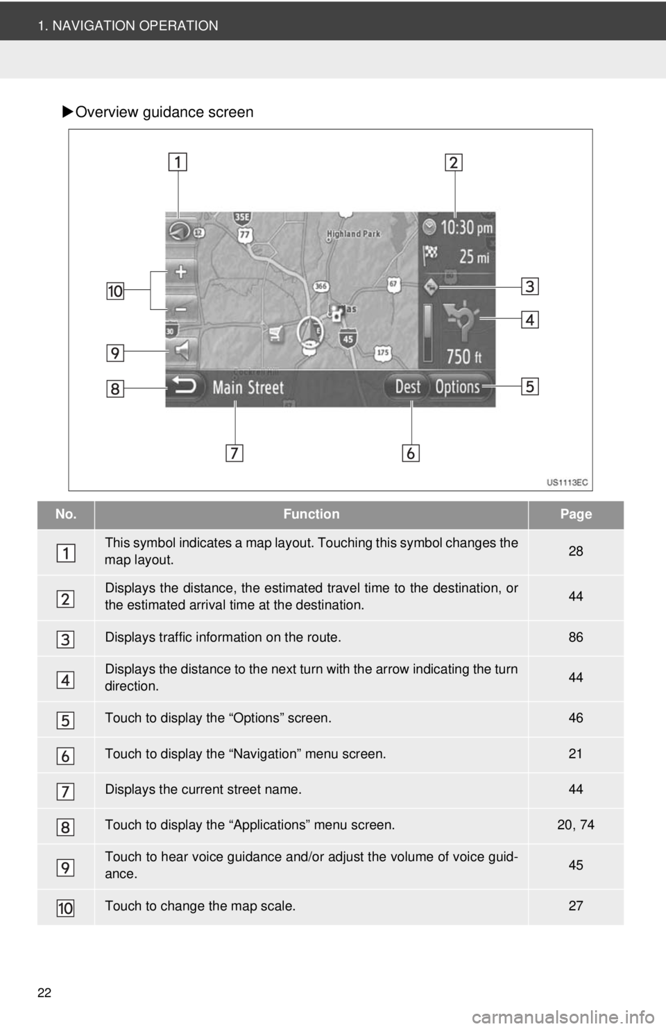
Overview guidance screen
No.FunctionPage
This symbol indicates a map layout. Touching th is symbol changes the
map layout.28
Displays the distance, the estimated travel time to the destination, or
the estimated arrival time at the destination.44
Displays traffic information on the route.86
Displays the distance to the next turn with the arrow indicating the turn
direction.44
Touch to display the “Options” screen.46
Touch to display the “Navigation” menu screen.21
Displays the current street name.44
Touch to display the “Applications” menu screen.20, 74
Touch to hear voice guidance and/or adjust the volume of voice guid-
ance.45
Touch to change the map scale.27
Page 25 of 228
25
2
APPLICATION-“Map”
1. NAVIGATION OPERATION
3. MAP SCREEN OPERATION
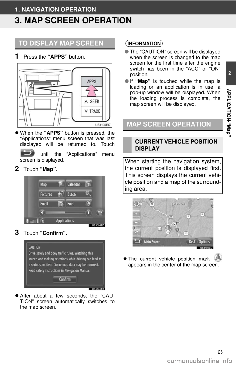
1Press the “APPS” button.
When the “APPS” button is pressed, the
“Applications” menu screen that was last
displayed will be returned to. Touch
until the “Applications” menu
screen is displayed.
2Touch “Map”.
3Touch “Confirm” .
After about a few seconds, the “CAU-
TION” screen automatically switches to
the map screen.
The current vehicle position mark
appears in the center of the map screen.
TO DISPLAY MAP SCREENINFORMATION
● The “CAUTION” screen will be displayed
when the screen is changed to the map
screen for the first time after the engine
switch has been in the “ACC” or “ON”
position.
● If “Map” is touched while the map is
loading or an application is in use, a
pop-up window will be displayed. When
the loading process is complete, the
map screen will be displayed.
MAP SCREEN OPERATION
CURRENT VEHICLE POSITION
DISPLAY
When starting the navigation system,
the current position is displayed first.
This screen displays the current vehi-
cle position and a map of the surround-
ing area.
Page 42 of 228
42
3. ROUTE GUIDANCE
1. STARTING ROUTE GUIDANCE
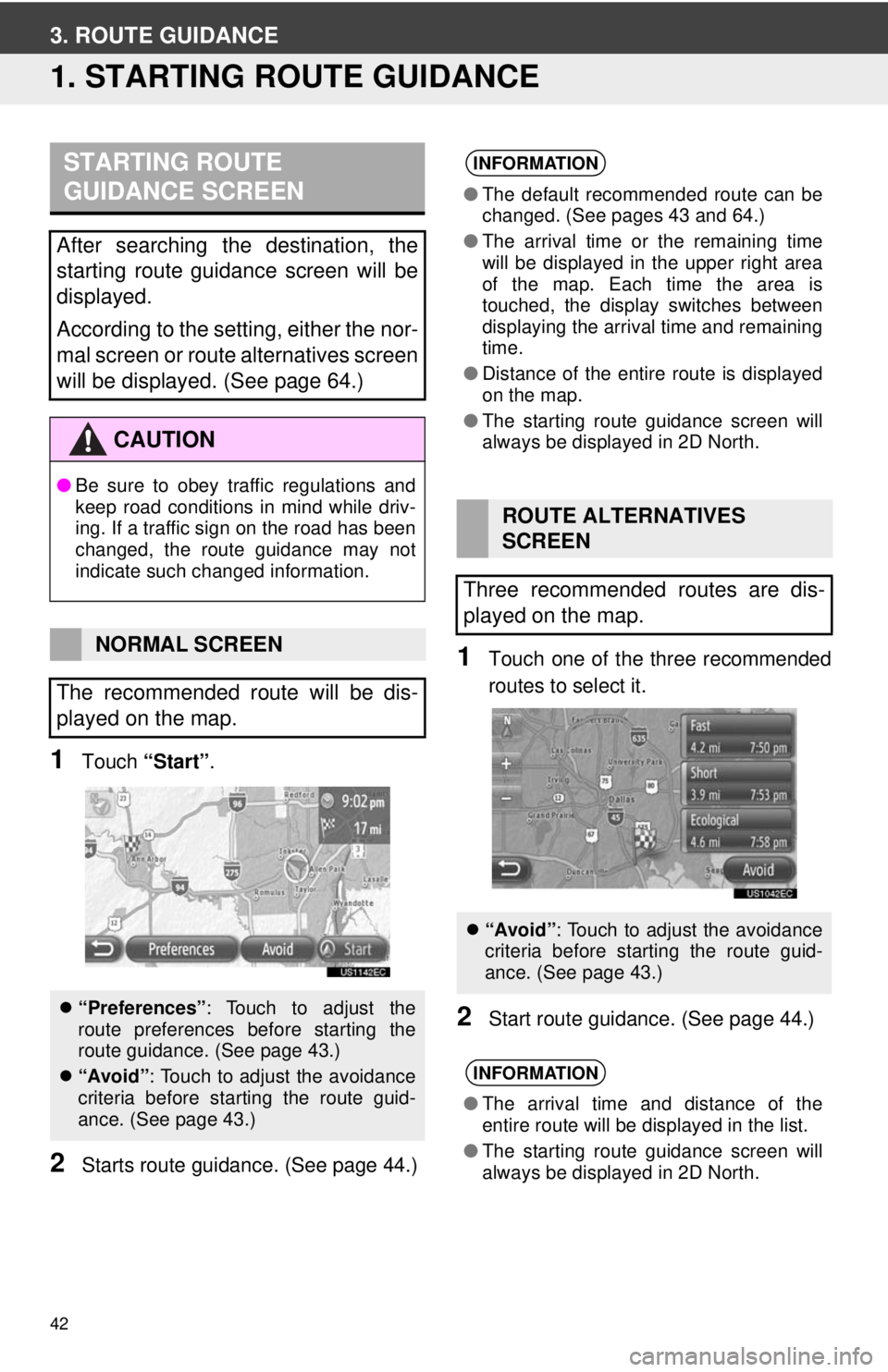
1Touch “Start” .
2Starts route guidan ce. (See page 44.)
1Touch one of the three recommended
routes to select it.
2Start route guidance. (See page 44.)
STARTING ROUTE
GUIDANCE SCREEN
After searching the destination, the
starting route guidance screen will be
displayed.
According to the setting, either the nor-
mal screen or route alternatives screen
will be displayed. (See page 64.)
CAUTION
●Be sure to obey traffic regulations and
keep road conditions in mind while driv-
ing. If a traffic sign on the road has been
changed, the route guidance may not
indicate such changed information.
NORMAL SCREEN
The recommended route will be dis-
played on the map.
“Preferences” : Touch to adjust the
route preferences before starting the
route guidance. (See page 43.)
“Avoid”: Touch to adjust the avoidance
criteria before starting the route guid-
ance. (See page 43.)
INFORMATION
●The default recommended route can be
changed. (See pages 43 and 64.)
● The arrival time or the remaining time
will be displayed in the upper right area
of the map. Each time the area is
touched, the display switches between
displaying the arrival time and remaining
time.
● Distance of the entire route is displayed
on the map.
● The starting route guidance screen will
always be displayed in 2D North.
ROUTE ALTERNATIVES
SCREEN
Three recommended routes are dis-
played on the map.
“Avoid”: Touch to adjust the avoidance
criteria before starting the route guid-
ance. (See page 43.)
INFORMATION
●The arrival time and distance of the
entire route will be displayed in the list.
● The starting route guidance screen will
always be displayed in 2D North.
Page 61 of 228
61
2
APPLICATION-“Map”
5. NAVIGATION SETTING
1. MAP SETTINGS
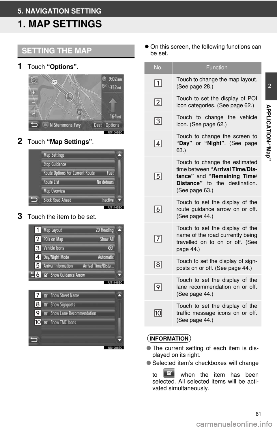
1Touch “Options”.
2Touch “Map Settings” .
3Touch the item to be set.
On this screen, the following functions can
be set.SETTING THE MAP
No.Function
Touch to change the map layout.
(See page 28.)
Touch to set the display of POI
icon categories. (See page 62.)
Touch to change the vehicle
icon. (See page 62.)
Touch to change the screen to
“Day” or “Night”. (See page
63.)
Touch to change the estimated
time between “Arrival Time/Dis-
tance” and “Remaining Time/
Distance” to the destination.
(See page 63.)
Touch to set the display of the
route guidance arrow on or off.
(See page 44.)
Touch to set the display of the
name of the road currently being
travelled on to on or off. (See
page 44.)
Touch to set the display of sign-
posts on or off. (See page 44.)
Touch to set the display of the
lane recommendation on or off.
(See page 44.)
Touch to set the display of the
traffic message icons on or off.
(See page 44.)
INFORMATION
● The current setting of each item is dis-
played on its right.
● Selected item’s checkboxes will change
to when the item has been
se
lected. All selected items will be acti-
vated simultaneously.
Page 63 of 228
63
5. NAVIGATION SETTING
2
APPLICATION-“Map”
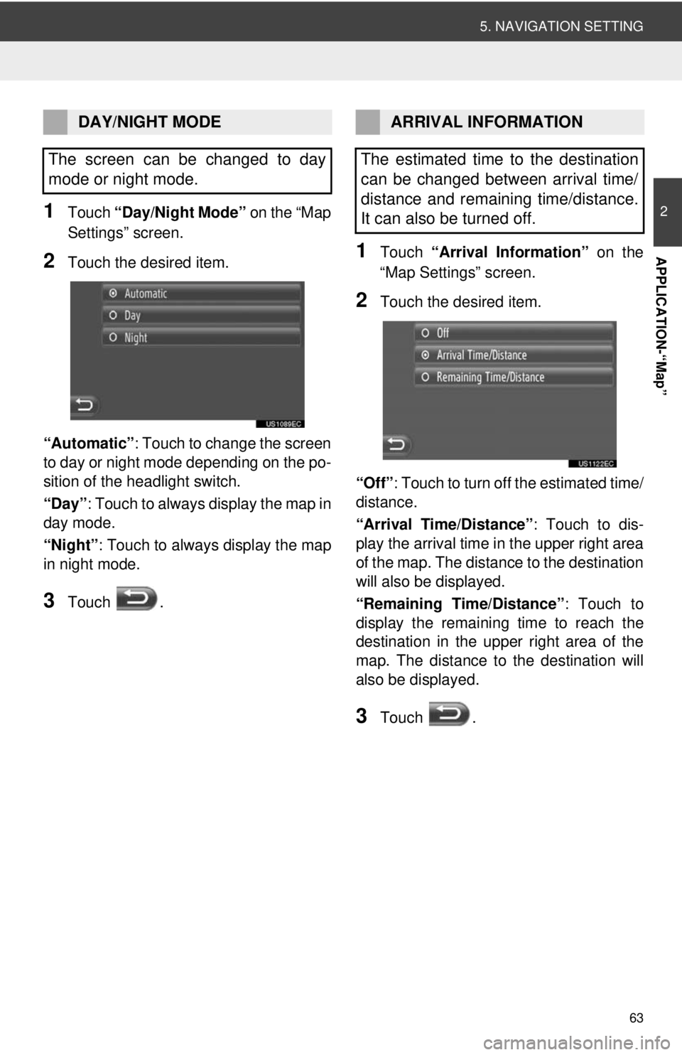
1Touch “Day/Night Mode” on the “Map
Settings” screen.
2Touch the desired item.
“Automatic” : Touch to change the screen
to day or night mode depending on the po-
sition of the headlight switch.
“Day” : Touch to always display the map in
day mode.
“Night”: Touch to always display the map
in night mode.
3Touch .
1Touch “Arrival Information” on the
“Map Settings” screen.
2Touch the desired item.
“Off” : Touch to turn off the estimated time/
distance.
“Arrival Time/Distance” : Touch to dis-
play the arrival time in the upper right area
of the map. The dist ance to the destination
will also be displayed.
“Remaining Time/Distance” : Touch to
display the remaining time to reach the
destination in the upper right area of the
map. The distance to the destination will
also be displayed.
3Touch .
DAY/NIGHT MODE
The screen can be changed to day
mode or night mode.ARRIVAL INFORMATION
The estimated time to the destination
can be changed between arrival time/
distance and remaining time/distance.
It can also be turned off.
Page 66 of 228
66
6. NAVIGATION SYSTEM INFORMATION
1. LIMITATIONS OF THE NAVIGATION SYSTEM
The Global Positioning System (GPS) de-
veloped and operated by the U.S. Depart-
ment of Defense provides an accurate
current vehicle position, normally using 4
or more satellites, and in some case 3 sat-
ellites. The GPS system has a certain level
of inaccuracy. While the navigation system
will compensate for this most of the time,
occasional positioning errors of up to 300
feet (100 m) can and should be expected.
Generally, position errors will be corrected
within a few seconds.
The GPS signal may be physically ob-
structed, leading to inaccurate vehicle po-
sition on the map display. Tunnels, tall
buildings, trucks, or even the placement of
objects on the instrument panel may ob-
struct the GPS signals.
The GPS satellites may not send signals
due to repairs or improvements being
made to them. Even when the navigation system is re-
ceiving clear GPS signals, the vehicle po-
sition may not be shown accurately or
inappropriate route guidance may occur in
some cases.
Accurate current vehicle position may not
be shown in the following cases:
• When driving on a small angled Y-
shaped road.
• When driving on a winding road.
• When driving on a slippery road such as in sand, gravel, snow, etc.
• When driving on a long straight road.
• When motorway and surface streets run in parallel.
• After moving by ferry or vehicle carrier.
• When a long route is searched during high speed driving.
• When driving without setting the current position calibration correctly.
• After repeating a change of direction by
going forward and backward, or turning
on a turntable in the parking lot.
• When leaving a covered parking lot or
parking garage.
• When a roof carrier is installed.
• When driving with tire chains installed.
• When the tires are worn.
• After replacing a tire or tires.
• When using tires that are smaller or
larger than the factory specifications.
• When the tire pressure in any of the four tires is not correct.
This navigation system calculates the
current vehicle position using satellite
signals, various vehicle signals, map
data, etc. However, an accurate posi-
tion may not be shown depending on
satellite condition, road configuration,
vehicle condition or other circumstanc-
es.
NOTICE
● The installation of window tinting may
obstruct the GPS signals. Most window
tinting contains some metallic content
that will interfere with GPS signal recep-
tion of the antenna. We advise against
the use of window tinting on vehicles
equipped with navigation systems.
Page 67 of 228
67
6. NAVIGATION SYSTEM INFORMATION
2
APPLICATION-“Map”
Inappropriate route guidance may occur in
the following cases:
• When turning at an intersection off the
designated route guidance.
• If you set more than one destination but
skip one of them, auto reroute will dis-
play a route returning to the destination
that was skipped.
• When turning at an intersection for which there is no route guidance.
• When passing through an intersection
for which there is no route guidance.
• During auto reroute, the route guidance may not be available for the next turn to
the right or left.
• It may take a long time to operate auto reroute during high speed driving. In
auto reroute, a detour route may be
shown.
• After auto reroute, the route may not be
changed.
• An unnecessary U-turn may be shown or announced.
• A location may have multiple names and the system will announce one or more.
• Some routes may not be searched.
• If the route to your destination includes gravel, unpaved roads or alleys, the
route guidance may not be shown.
• Your destination point might be shown on the opposite side of the street.
• When a portion of the route has regula-
tions prohibiting the entry of the vehicle
that vary by time or season or other rea-
sons.
• The road and map data stored in the navigation system may not be complete
or may not be the latest version.
INFORMATION
● This navigation system uses tire turning
data and is designed to work with fac-
tory-specified tires for the vehicle.
Installing tires that are larger or smaller
than the originally equipped diameter
may cause inaccurate display of the cur-
rent vehicle position. The tire pressure
also affects the diameter of the tires so
make sure the tire pressure of all four
tires is correct.
Page 102 of 228
102
1. AUDIO SYSTEM OPERATION
2. SOME BASICS
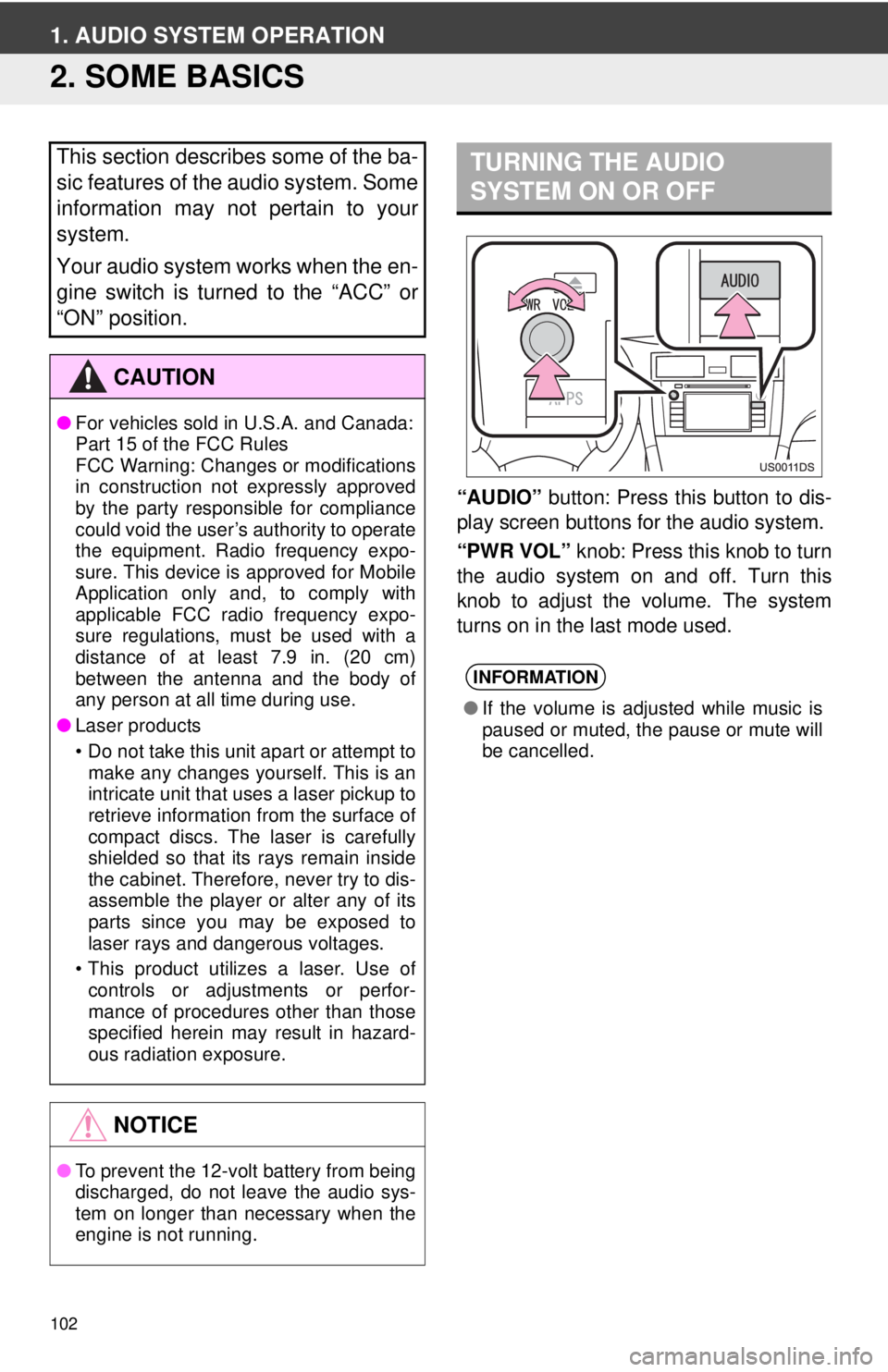
“AUDIO” button: Press this button to dis-
play screen buttons for the audio system.
“PWR VOL” knob: Press this knob to turn
the audio system on and off. Turn this
knob to adjust the volume. The system
turns on in the last mode used.
This section describes some of the ba-
sic features of the audio system. Some
information may not pertain to your
system.
Your audio system works when the en-
gine switch is turned to the “ACC” or
“ON” position.
CAUTION
● For vehicles sold in U.S.A. and Canada:
Part 15 of the FCC Rules
FCC Warning: Changes or modifications
in construction not expressly approved
by the party responsible for compliance
could void the user’s authority to operate
the equipment. Radio frequency expo-
sure. This device is approved for Mobile
Application only and, to comply with
applicable FCC radio frequency expo-
sure regulations, must be used with a
distance of at least 7.9 in. (20 cm)
between the antenna and the body of
any person at all time during use.
● Laser products
• Do not take this unit apart or attempt to
make any changes yourself. This is an
intricate unit that uses a laser pickup to
retrieve information from the surface of
compact discs. The laser is carefully
shielded so that its rays remain inside
the cabinet. Therefore, never try to dis-
assemble the player or alter any of its
parts since you may be exposed to
laser rays and dangerous voltages.
• This product utilizes a laser. Use of controls or adjustments or perfor-
mance of procedures other than those
specified herein may result in hazard-
ous radiation exposure.
NOTICE
● To prevent the 12-volt battery from being
discharged, do not leave the audio sys-
tem on longer than necessary when the
engine is not running.
TURNING THE AUDIO
SYSTEM ON OR OFF
INFORMATION
●If the volume is adjusted while music is
paused or muted, the pause or mute will
be cancelled.