turn signal TOYOTA xB 2011 Accessories, Audio & Navigation (in English)
[x] Cancel search | Manufacturer: TOYOTA, Model Year: 2011, Model line: xB, Model: TOYOTA xB 2011Pages: 284, PDF Size: 32.36 MB
Page 2 of 284

1
V573_E
Introduction
Thank you for your purchase of the Navigation System. Please
read this manual carefully to ensure proper use. Keep this
manual in your vehicle at all times.
The Navigation System is one of the most technologically advanced
vehicle accessories ever developed. The system receives satellite
signals from the Global Positioning System (GPS) operated by the U.S.
Department of Defense. Using these signals and other vehicle sen-
sors, the system indicates your present position and assists in locating
a desired destination.
The navigation system is designed to select efficient routes from your
present starting location to your destination. The system is also de-
signed to direct you to a destination that is unfamiliar to you in an effi-
cient manner. Map database is made based on AISIN AW maps,
whose information source comes from NAVTEQ maps. The calcu-
lated routes may not be the shortest nor the least traffic congested.
Your own personal local knowledge or “short cut” may at times be
faster than the calculated routes.
The navigation system’s database includes about 110 Point of Interest
categories to allow you to easily select destinations such as restau-
rants and hotels. If a destination is not in the database, you can enter
the street address or a major intersection close to it and the system will
guide you there.
The system will provide both a visual map and audio instructions.
The audio instructions will announce the distance remaining and the
direction to turn in approaching a fork or intersection. These voice in-
structions will help you keep your eyes on the road and are timed to
provide enough time to allow you to maneuver, change lanes or slow
down.
Page 28 of 284

BASIC FUNCTION
27
V573_E
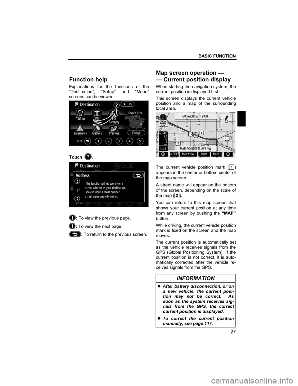
Explanations for the functions of the
“Destination”, “Setup” and “Menu”
screens can be viewed.
Touch .
: To view the previous page.
: To view the next page.
: To return to the previous screen.
When starting the navigation system, the
current position is displayed first.
This screen displays the current vehicle
position and a map of the surrounding
local area.
The current vehicle position mark ()
appears in the center or bottom center of
the map screen.
A street name will appear on the bottom
of the screen, depending on the scale of
the map (
).
You can return to this map screen that
shows your current position at any time
from any screen by pushing the “MAP”
button.
While driving, the current vehicle position
mark is fixed on the screen and the map
moves.
The current position is automatically set
as the vehicle receives signals from the
GPS (Global Positioning System). If the
current position is not correct, it is auto-
matically corrected after the vehicle re-
ceives signals from the GPS.
INFORMATION
�z After battery disconnection, or on
a new vehicle, the current posi-
tion may not be correct. As
soon as the system receives sig-
nals from the GPS, the correct
current position is displayed.
�z To correct the current position
manually, see page 117.
Function hel
p
Map screen operation — —Current position display
Page 63 of 284

DESTINATION SEARCH
62
V573_E
INFORMATION
�z Guidance can be suspended or
resumed. (See “Suspending and
resuming guidance” on page 86.)
�z If “Guide” is touched until a beep
sounds, demo mode will start.
Push the “MAP” button to finish
demo mode.
�z The route for returning may not
be the same as that for going.
�z The route guidance to the desti-
nation may not be the shortest
route nor a route without traffic
congestion.
�z Route guidance may not be avail-
able if there is no road data for
the specified location.
�z When setting the destination on a
map with a scale larger than 0.5
miles (800 m), the map scale
changes to 0.5 miles (800 m)
automatically. Set the destina-
tion again.
�z If a destination is entered, the
road nearest to the point you se-
lected is set as the destination.
CAUTION
Be sure to obey traffic regulations
and keep road conditions in mind
while driving. If a traffic sign on
the road has been changed, the
route guidance may provide wrong
information.
�z To change the route before start-
ing guidance
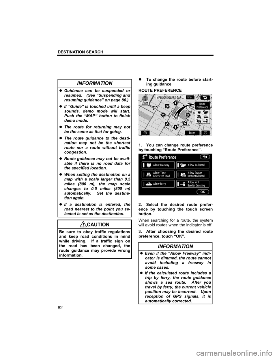
ROUTE PREFERENCE
1. You can change route preference
by touching “Route Preference”.
2. Select the desired route prefer-
ence by touching the touch screen
button.
When searching for a route, the system
will avoid routes when the indicator is off.
3. After choosing the desired route
preference, touch “OK”.
INFORMATION
�z Even if the “Allow Freeway” indi-
cator is dimmed, the route cannot
avoid including a freeway in
some cases.
�z If the calculated route includes a
trip by ferry, the route guidance
shows a sea route. After you
travel by ferry, the current vehicle
position may be incorrect. Upon
reception of GPS signals, it is
automatically corrected.
Page 188 of 284

AUDIO/VIDEO SYSTEM
187
V573_E
�z SSP (SCION Sound Processing)
settings
SSP is a modified DSP (Digital Signal
Processing) system that provides a cus-
tomized sound for your vehicle. You
can select from the modes below.
“Natural”: A subdued sound that does
not interfere with conversations.
“Hear”: A powerful, energetic, “live”
sound.
“Feel”: Player’s sound −> reproduces
the sound on the stage that musicians
hear.
For more details, please visit the SCION
Web site at http://www.scion.com/.
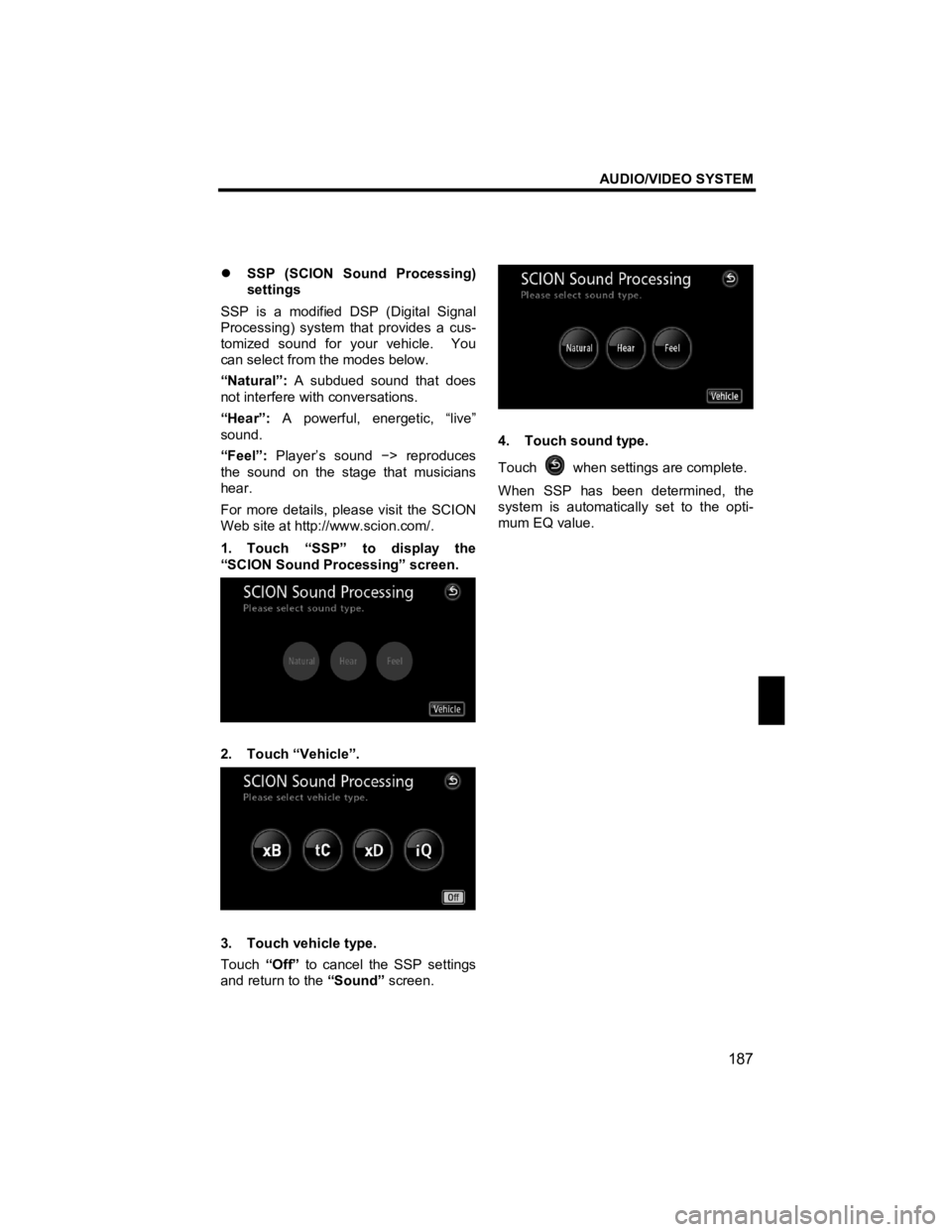
1. Touch “SSP” to display the
“SCION Sound Processing” screen.
2. Touch “Vehicle”.
3. Touch vehicle type.
Touch “Off” to cancel the SSP settings
and return to the “Sound” screen.
4. Touch sound type.
Touch
when settings are complete.
When SSP has been determined, the
system is automatically set to the opti-
mum EQ value.
Page 201 of 284

AUDIO/VIDEO SYSTEM
200
V573_E
�z If the satellite radio tuner malfunctions
When problems occur with the XM® tuner, a message will appear on the display. Re-
ferring to the table below to identify the problem, take the suggested corrective action.
The XM
® antenna is not connected. Check whether the XM® an-
tenna cable is attached securely.
ANTENNA A short circuit occurs in the antenna or the surrounding antenna
cable. See a Toyota certified dealer for assistance.
You have not subscribed to the XM® Satellite Radio. The radio is
being updated with the latest encryption code. Contact the XM®
Satellite Radio for subscription information. When a contract is
canceled, you can choose the “CH000” and all free −to −air chan-
nels.
UPDATING The premium channel you selected is not authorized. Wait for
about 2 seconds until the radio returns to the previous channel or
“CH001”. If it does not change automatically, select another
channel. If you want to listen to the premium channel, contact the
XM
® Satellite Radio.
NO SIGNAL The XM® signal is too weak at the current location. Wait until your
vehicle reaches a location with a stronger signal.
LOADING The unit is acquiring audio or program information. Wait until the
unit has received the information.
OFF AIR The channel you selected is not broadcasting any programming.
Select another channel.
−−−−−
There is no song/program title or artist name/feature associated
with the channel at that time. No action needed.
−−−
The channel you selected is no longer available. Wait for about 2
seconds until the radio returns to the previous channel or
“CH001”. If it does not change automatically, select another
channel.
Contact the XM® Listener Care Center at 1
−800 −967 −2346 (U.S.A.) or
1 − 877 −438 −9677 (Canada).
Page 272 of 284

APPENDIX
271
V573_E
(a) Accurate current vehicle position
may not be shown in the following
cases:
�z When driving on a small angled
Y-shaped road.
�z When driving on a winding road.
�z When driving on a slippery road
such as in sand, gravel, snow, etc.
�z When driving on a long straight road.
�z When freeway and surface streets
run in parallel.
�z After moving by ferry or vehicle car-
rier.
�z When a long route is searched dur-
ing high speed driving.
�z When driving without setting the
current position calibration correctly.
�z After repeating a change of direction
by going forward and backward, or
turning on a turntable in the parking
lot.
�z When leaving a covered parking lot
or parking garage.
�z When a roof carrier is installed.
�z When driving with tire chains in-
stalled.
�z When the tires are worn.
�z After replacing a tire or tires.
�z When using tires that are smaller or
larger than the factory specifications.
�z When the tire pressure in any of the
four tires is not correct.
INFORMATION
If your vehicle cannot receive GPS
signals, you can correct the current
position manually. For information
on setting the current position cali-
bration, see page 117.
(b) Inappropriate route guidance may
occur in the following cases:
�z When turning at an intersection off
the designated route guidance.
�z If you set more than one destination
but skip any of them, auto reroute
will display a route returning to the
destination on the previous route.
�z When turning at an intersection for
which there is no route guidance.
�z When passing through an intersec-
tion for which there is no route
guidance.
�z During auto reroute, the route guid-
ance may not be available for the
next turn to the right or left.
�z It may take a long time to operate
auto reroute during high speed driv-
ing. In auto reroute, a detour route
may be shown.
�z After auto reroute, the route may not
be changed.
�z An unnecessary U-turn may be
shown or announced.
�z A location may have multiple names
and the system will announce one or
more.
�z Some routes may not be searched.
�z If the route to your destination in-
cludes gravel, unpaved roads or al-
leys, the route guidance may not be
shown.
�z Your destination point might be
shown on the opposite side of the
street.
�z When a portion of the route has
regulations prohibiting the entry of
the vehicle that vary by time or sea-
son or other reasons.
�z The road and map data stored in
your navigation system may not be
complete or may not be the latest
version.