display Acura RDX 2011 Navigation Manual
[x] Cancel search | Manufacturer: ACURA, Model Year: 2011, Model line: RDX, Model: Acura RDX 2011Pages: 176, PDF Size: 4.42 MB
Page 15 of 176
14Navigation System
Getting Started
Using the Voice Control System
You should use the voice control system
as much as possible, and consider
manual entry using the Interface Dial
as a backup method of entry.
Most of the system’s functions can be
controlled by voice commands activated
with the NAVI TALK button. To
control the navigation system by voice:
• Press and release the NAVI TALK
button.
• Wait for the beep (the icon is displayed on the top left of the
screen).
• Give a voice command.
Once the microphone picks up your
command, the system changes the
display in response to the command and
prompts you for the next command.
Using the NAVI TALK button, answer
the prompts as required. If the system does not understand a
command or you wait too long to give a
command, it responds with “Pardon,”
“Please repeat,” or “Would you say
again.” If the system cannot perform a
command or the command is not
appropriate for the screen you are on, it
sounds a beep.
Anytime you are unsure of what voice
commands are available on a screen,
you can always say “Help.” The system
will then read the list of available
commands to you.
When you give a command, the system
generally either repeats the command as
a confirmation or asks you for further
information. If you do not wish to hear
this feedback, you can turn it off.
However, hearing the feedback will
familiarize you with the way the system
expects commands to be phrased. See
the
Voice Recognition Feedback
setting in SETUP. If you hear a prompt such as “Please use
the Interface Dial to...” or “Please
choose an area with the Interface Dial,”
the system is asking for input that
cannot be performed using the voice
control system.
Improving Voice Recognition
To achieve optimum voice recognition
when using either the navigation or
Bluetooth
® HandsFreeLink® voice
control system, the following guidelines
should be followed:
NOTE:
Make sure the correct screen is
displayed for the vo ice command that
you are using. See Voice Command
Index on page 158.
• It is best if the windows and sunroof are closed. If you drive with the
windows or sunroof open, speak a
little louder to overcome the wind
noises.
Page 16 of 176
Navigation System15
Getting Started
• Adjust the dashboard and side vents
so air does not blow against the
microphone on the ceiling.
• If more than one person is speaking at the same time, the system may
misinterpret your command.
• After pressing and releasing the NAVI TALK button, wait for the
beep, then give a voice command
while the icon is displayed on the
top left of the screen.
• Give a voice command in a clear, natural speaking voice without
pausing between words.
• If the system cannot recognize your command because of background
noise, speak louder.
• If you are still having trouble with the voice control sy stem, refer to Voice
Command Help on the INFO
screen ( Other) or say “Help” while
the icon is displayed on the top
left of the screen.Selecting an Item (Button)
on the Screen
On most screens, there are items that
can be selected (like buttons with titles
such as OK or Return ). To select an
item on any screen, do one of the
following:
• Use the voice control system and say the name of the desired item. Almost
all selectable items on the screen,
including some listed items, are
recognized by the voice control
system.
• Move the highlighting to the desired item with the Interface Dial or its
knob , then push in on the Interface
Dial .
Tip:
If items are grayed out, this means that
they cannot be selected.
Selecting an Item in a List
To scroll through a list, do one of the
following:
• Rotate the Interface Dial knob to
scroll one item at a time.
• Use the voice control system to scroll page by page. For example, to scroll
up, say “Up” or “Previous.” To scroll
down, say “Next” or “Down.”
• Move the Interface Dial up or down
to scroll through the list page by
page.
If you cannot find the desired name, or
have made an error, return to the
previous screen by pressing the
CANCEL or the NAVI BACK button
on the steering wheel.
To select the desired item in the list, do
one of the following:
• Use the voice control system, and say the item number of the desired item.
• Rotate the Interface Dial knob to
move the highlighting to the item,
then push in on the Interface Dial.
Page 17 of 176
16Navigation System
Getting Started
Entering Information
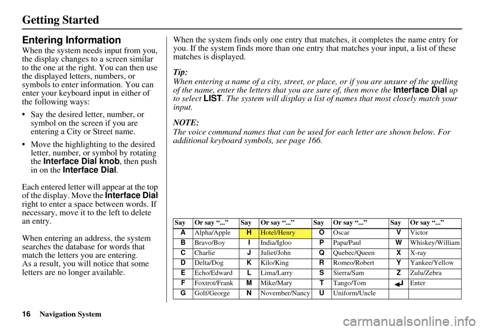
When the system needs input from you,
the display changes to a screen similar
to the one at the right. You can then use
the displayed letters, numbers, or
symbols to enter information. You can
enter your keyboard input in either of
the following ways:
• Say the desired letter, number, or symbol on the screen if you are
entering a City or Street name.
• Move the highlighting to the desired letter, number, or symbol by rotating
the Interface Dial knob , then push
in on the Interface Dial .
Each entered letter will appear at the top
of the display. Move the Interface Dial
right to enter a space between words. If
necessary, move it to the left to delete
an entry.
When entering an address, the system
searches the database for words that
match the letters you are entering.
As a result, you will notice that some
letters are no longer available. When the system find
s only one entry that matches, it completes the name entry for
you. If the system finds more than one entry that matches your input, a list of these
matches is displayed.
Tip:
When entering a name of a city, street, or place, or if you are unsure of the spelling
of the name, enter the letters that you are sure of, then move the Interface Dial up
to select LIST. The system will display a list of names that most closely match your
input.
NOTE:
The voice command names that can be used for each letter are shown below. For
additional keyboard symbols, see page 166.
Say Or say “...” Say Or say “...” Say Or say “...” Say Or say “...”
A Alpha/Apple
HHotel/Henry OOscar VVictor
B Bravo/Boy IIndia/Igloo PPapa/Paul WWhiskey/William
C Charlie JJuliet/John QQuebec/Queen XX-ray
D Delta/Dog KKilo/King RRomeo/Robert YYankee/Yellow
E Echo/Edward LLima/Larry SSierra/Sam ZZulu/Zebra
F Foxtrot/Frank MMike/Mary TTango/Tom Enter
G Golf/George NNovember/Nancy UUniform/Uncle
Page 18 of 176
Navigation System17
Getting Started
System Start-up
When you turn the ignition to ON (II), it
takes several seconds for the navigation
system to boot up.
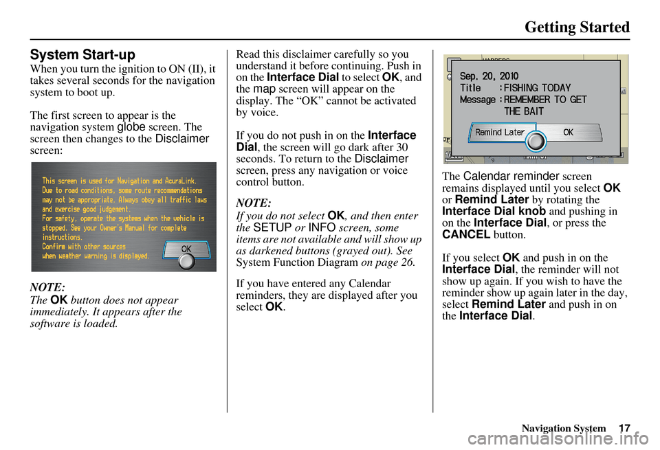
The first screen to appear is the
navigation system globe screen. The
screen then changes to the Disclaimer
screen:
NOTE:
The OK button does not appear
immediately. It appears after the
software is loaded. Read this disclaimer carefully so you
understand it before continuing. Push in
on the Interface Dial
to select OK, and
the map screen will appear on the
display. The “OK” cannot be activated
by voice.
If you do not push in on the Interface
Dial , the screen will go dark after 30
seconds. To return to the Disclaimer
screen, press any navigation or voice
control button.
NOTE:
If you do not select OK, and then enter
the SETUP or INFO screen, some
items are not available and will show up
as darkened buttons (grayed out). See
System Function Diagram on page 26.
If you have entered any Calendar
reminders, they are displayed after you
select OK. The
Calendar reminder screen
remains displayed until you select OK
or Remind Later by rotating the
Interface Dial knob and pushing in
on the Interface Dial , or press the
CANCEL button.
If you select OK and push in on the
Interface Dial , the reminder will not
show up again. If you wish to have the
reminder show up agai n later in the day,
select Remind Later and push in on
the Interface Dial .
Page 19 of 176
18Navigation System
Getting Started
If you press the CANCEL button, the
message will be displayed the next time
you start the vehicle.
NOTE:
The system will display the current
message and any older or previously
unread messages, with the newest
message listed first.Bluetooth® HandsFreeLink®
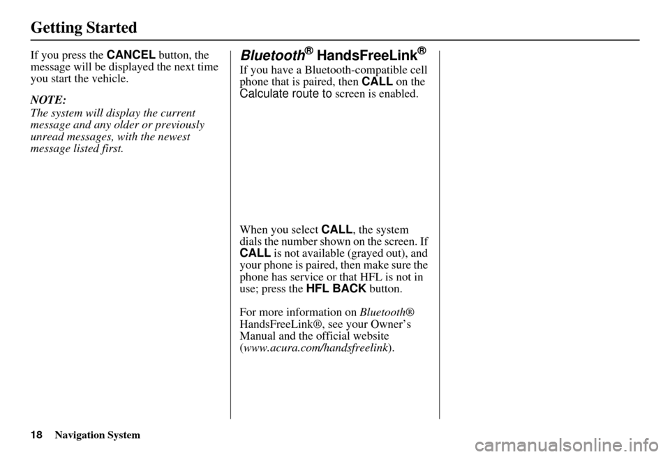
If you have a Bluetooth-compatible cell
phone that is paired, then CALL on the
Calculate route to screen is enabled.
When you select CALL, the system
dials the number shown on the screen. If
CALL is not available (grayed out), and
your phone is paired, then make sure the
phone has service or that HFL is not in
use; press the HFL BACK button.
For more information on Bluetooth®
HandsFreeLink®, see your Owner’s
Manual and the official website
(www.acura.com/handsfreelink ).
Page 20 of 176
Navigation System19
Getting Started
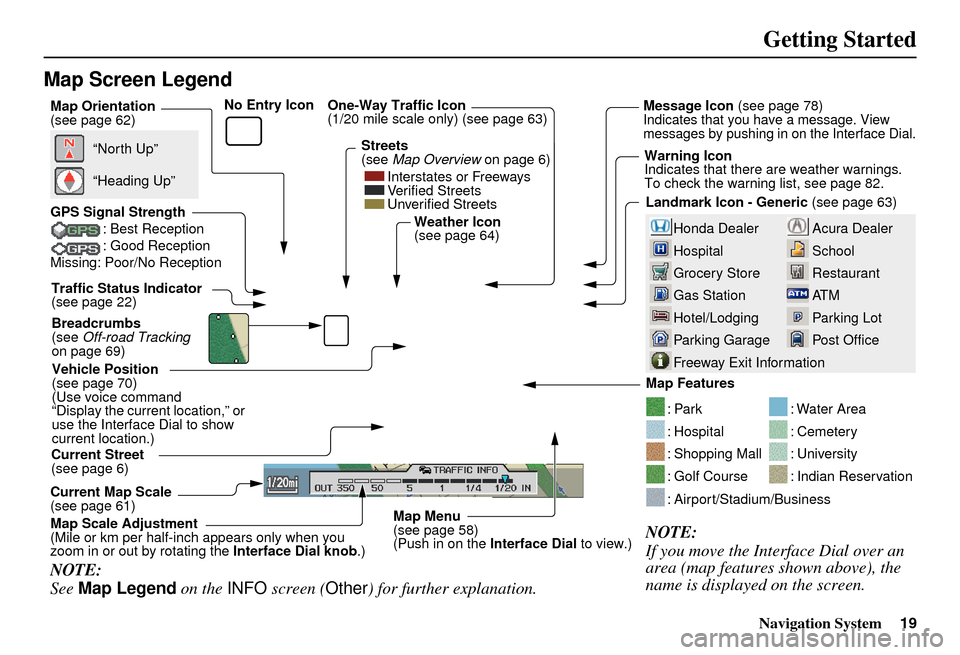
Map Screen Legend
Acura Dealer
School
Restaurant
AT M
Parking Lot
Post OfficeHonda Dealer
Hospital
Grocery Store
Gas Station
Hotel/Lodging
Parking Garage
Freeway Exit Information
Vehicle Position
(see page 70)
(Use voice command
“Display the current location,” or
use the Interface Dial to show
current location.) Landmark Icon - Generic
(see page 63)
Current Map Scale
(see page 61) Map Features
NOTE:
If you move the Interface Dial over an
area (map features shown above), the
name is displayed on the screen.
: Par k
: Hospital
: Shopping Mall
: Golf Course
: Water Area
: Cemetery
: University
: Indian Reservation
: Airport/Stadium/Business
Current Street
(see page 6)
NOTE:
See
Map Legend on the INFO screen ( Other) for further explanation.
GPS Signal Strength
: Best Reception
: Good Reception
Missing: Poor/No Reception
“North Up”
“Heading Up”
Map Orientation
(see page 62)
Map Menu
(see page 58)
(Push in on the Interface Dial to view.)
Map Scale Adjustment
(Mile or km per half-inch appears only when you
zoom in or out by rotating the
Interface Dial knob.)
Traffic Status Indicator
(see page 22)
Breadcrumbs
(see Off-road Tracking
on page 69) Weather Icon
(see page 64)
One-Way Traffic Icon
(1/20 mile scale only) (see page 63) Message Icon
(see page 78)Indicates that you ha ve a message. View
messages by pushing in on the Interface Dial.
Warning Icon
Indicates that there are weather warnings.
To check the warning list, see page 82.
Streets
(see
Map Overview on page 6)
Interstates or Freeways
Verified Streets
Unverified Streets
No Entry Icon
Page 21 of 176
20Navigation System
Getting Started
Map Screen Description
Zoom In/Out
Rotate the Interface Dial knob to
change the map scale. Zooming in
increases the detail, while zooming out
gives you a wide area view. After
changing the scale, give the system a
few moments to update the display.
Map Scrolling
To view other map areas, move the
Interface Dial left, right, up, or down.
The map will shift in that direction. To
return the map to you r current location,
press either the MAP/GUIDE ,
CANCEL , or NAVI BACK button on
the steering wheel.
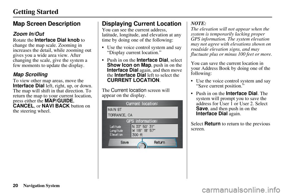
Displaying Current Location
You can see the current address,
latitude, longitude, a nd elevation at any
time by doing one of the following:
• Use the voice control system and say “Display current location.”
• Push in on the Interface Dial, select
Show Icon on Map , push in on the
Interface Dial again, and then move
the Interface Dial left to select the
CURRENT LOCATION .
The Current location screen will
appear on the display. NOTE:
The elevation will not appear when the
system is temporarily lacking proper
GPS information. Th
e system elevation
may not agree with elevations shown on
roadside elevation signs, and may
fluctuate plus or minus 100 feet or more.
You can save the current location in
your Address Book by doing one of the
following:
• Use the voice control system and say “Save current position.”
• Push in on the Interface Dial. The
system will prompt you to save the
address for User 1 or User 2. Select
Save , and then push in on the
Interface Dial again.
Select Return to return to the previous
screen.
Page 22 of 176
Navigation System21
Getting Started
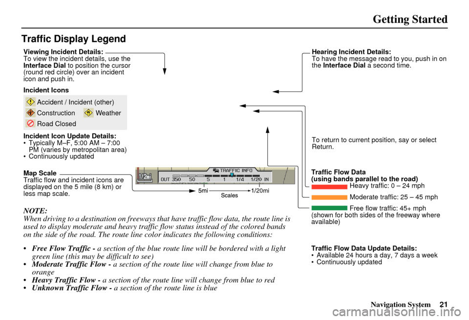
Traffic Display Legend
20mi
NOTE:
When driving to a destination on freeways that have traffic flow data, the route line is
used to display moderate and heavy traffic flow status instead of the colored bands
on the side of the road. The route line color indicates the following conditions:
Free Flow Traffic - a section of the blue route line will be bordered with a light
green line (this may be difficult to see)
Moderate Traffic Flow - a section of the route line will change from blue to
orange
Heavy Traffic Flow - a section of the route line will change from blue to red
Unknown Traffic Flow - a section of the route line is blue
Map Scale
Traffic flow and incident icons are
displayed on the 5 mile (8 km) or
less map scale. Incident Icons
Incident Icon Update Details:
Typically M–F, 5:00 AM – 7:00
PM (varies by metropolitan area)
Continuously updated
Accident / Incident (other)
Construction
Road Closed
Weather
Traffic Flow Data
(using bands parallel to the road) Heavy traffic: 0 – 24 mph
Moderate traffic: 25 – 45 mph
Free flow traffic: 45+ mph
(shown for both sides of the freeway where
available)
Viewing Incident Details:
To view the incident
details, use the
Interface Dial to position the cursor
(round red circle) over an incident
icon and push in. Hearing Incident Details:
To have the message read to you, push in on
the
Interface Dial a second time.
To return to current position, say or select
Return.
Traffic Flow Data Update Details:
Available 24 hours a day, 7 days a week
Continuously updated
Page 23 of 176
22Navigation System
Getting Started
AcuraLink Real-Time
Traffic™
The navigation screen can display up-
to-the-minute traffic information when
available, including flow (traffic speed),
accidents, and construction on freeways
in more than 40 major metro areas. See
page 142 for a list of the current U.S.
cities that offer traffic information.
The display of traffic flow and incidents
on your map screen is optional and can
be turned On/Off by selecting the
“Traffic” icon on the Icon bar
(see Showing Icons on the Map on
page 67). The current metropolita
n areas that have
traffic coverage can be seen on
page 142. For more current metro
coverage information, go to
www.acura.com/realtimetraffic . This
link offers additional information on
real-time information, including the
following:
• The latest list of metro areas that have AcuraLink Real-Time Traffic
• Detailed coverage information for each metro area showing what roads
have traffic speed, traffic icons, or
both
• An AcuraLink Real-Time Traffic demonstration
• Frequently asked questions (FAQs)
NOTE:
Real-Time Traffic relies on a satellite signal. It will not work correctly in
Hawaii and Alaska.
AcuraLink Real-Time Traffic is only available if you have a current traffic
subscription with XM
®. See
page 115 for more information.
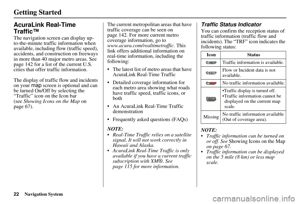
Traffic Status Indicator
You can confirm the r eception status of
traffic information (traffic flow and
incidents). The “TRF” icon indicates the
following status:
NOTE:
Traffic information can be turned on or off. See Showing Icons on the Map
on page 67.
Traffic information can be displayed on the 5 mile (8 km) or less map
scale.
Icon Status
Traffic information is available.
Flow or Incident data is not
available.
No traffic information available.
•Traffic display is turned off.•Traffic informat ion cannot be
displayed on the current map
scale.
Missing No traffic information available
(Out of coverage area).
Page 24 of 176
Navigation System23
Getting Started
Viewing Flow Data
Traffic flow data is displayed as colored
bands on either side of the freeway (see
Traffic Display Legend on page 21).
The different colored bands represent
the average road speeds as determined
by under-road sensors.
While driving to your destination on a
road that has traffic flow data, your
route line color is used to display the
traffic flow data. This means that when
the map scale is set to one of the traffic
scales (1/20 through 5 mile scale), your
blue route line may appear as alternating
orange, red, or blue segments (see
Traffic Display Legend on page 21).
NOTE:
A blue route line segment on a freeway
can mean one of two things:
Under-road sensors, GPS probes, cell phone probes, and other methods
used to collect traffic speed
information indicate free flow traffic.
The road has no sensors, and traffic conditions are unknown (they could
be congested). Naturally, only roads with these sensors
or probes will show traffic information.
The amount of flow data varies
considerably from one city to another.
This map display is refreshed
continuously. You can only view traffic
information in the city where you are
located.
NOTE:
Traffic flow and incident icons are
displayed on the 5 miles (8 km) or
less map scale.
Not all freeways within a metropolitan area have traffic flow
data (colored bands on the side of the
freeways) - this is normal, and you
cannot assume that a lack of data
implies no traffic.
Not all cities have traffic flow information. See cities listed on
page 142.
Due to freeway maintenance and construction, traffic flow may be
available only for one side of a road,
or be missing entirely for some
portion of the freeway. The displayed traffic flow may
disagree with information from other
audio or Internet-based traffic
displays.
If traffic flow is not showing, verify that the “TRAFFIC” selection for the
Icon Bar is ON, and that the icon
options for traffic are both ON (see
page 67).