display Acura RDX 2011 Navigation Manual
[x] Cancel search | Manufacturer: ACURA, Model Year: 2011, Model line: RDX, Model: Acura RDX 2011Pages: 176, PDF Size: 4.42 MB
Page 46 of 176
Navigation System45
When finishing a “Today’s
Destinations” trip, the Today’s
Destinations list entries are stored to
this list, beginning with the date (e.g.,
item 1 shown on the previous screen).
Because both the Home and personal Address Book list can be protected by
a PIN, they do not show up in the
previous destination list.
Scroll through the lis t and say the line
number (1-6) of the destination, or
select the desired destination you want.
Once you select the desired destination,
the system then displays the Calculate
route to screen (see Driving to Your
Destination on page 51).
NOTE:
Prior to departure, you can set areas to avoid. The system then includes
them in its calculations for the
destination you have entered. See
Edit Avoid Area on page 105.
For information on the available voice commands, see Voice
Command Index on page 158.By Map Input
After you select Map Input from the
MENU screen ( Enter destination by),
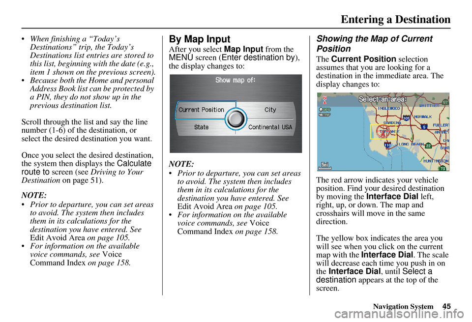
the display changes to:
NOTE:
Prior to departure, you can set areas to avoid. The system then includes
them in its calculations for the
destination you have entered. See
Edit Avoid Area on page 105.
For information on the available voice commands, see Voice
Command Index on page 158.
Showing the Map of Current
Position
The Current Position selection
assumes that you are looking for a
destination in the immediate area. The
display changes to:
The red arrow indicates your vehicle
position. Find your desired destination
by moving the Interface Dial left,
right, up, or down. The map and
crosshairs will move in the same
direction.
The yellow box indicates the area you
will see when you click on the current
map with the Interface Dial . The scale
will decrease each time you push in on
the Interface Dial , until Select a
destination appears at the top of the
screen.
Entering a Destination
Page 47 of 176
46Navigation System
If desired, rotate the Interface Dial
knob to change the map scale. When you
have the crosshairs in the desired icon,
map feature, or road, push in on the
Interface Dial. The address of the
location will appear at the top of the
screen.
NOTE:
The selected icon or road segment is
displayed on the 1/2 mile (800 meter) or
less map scale.
If this is the desired address, push in on
the Interface Dial again. If not, use the
Interface Dial to reposition the
crosshairs, then push in on the
Interface Dial again to display the new
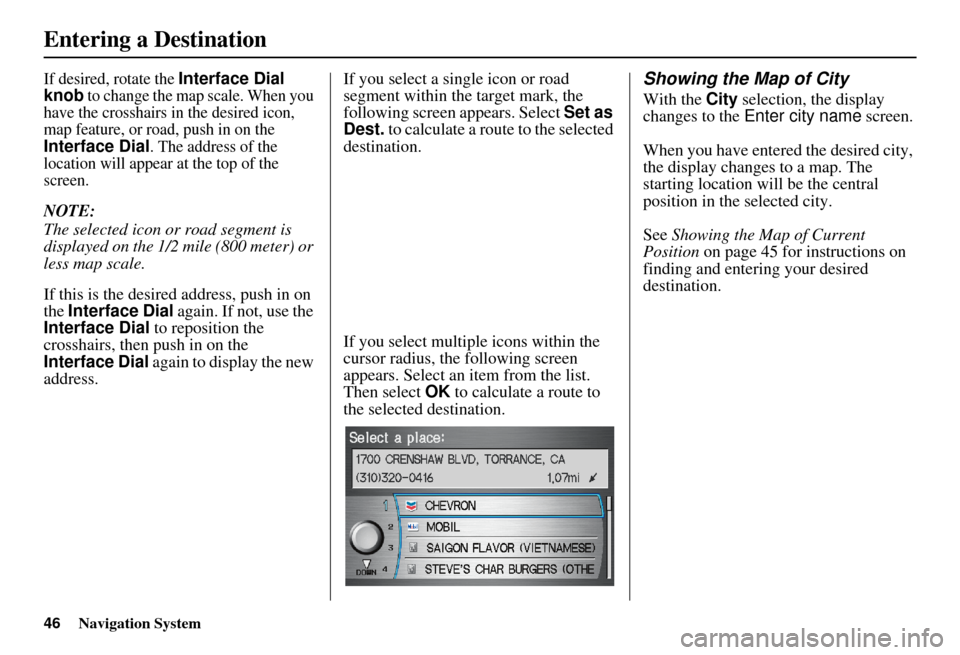
address. If you select a single icon or road
segment within the target mark, the
following screen appears. Select
Set as
Dest. to calculate a route to the selected
destination.
If you select multiple icons within the
cursor radius, the following screen
appears. Select an item from the list.
Then select OK to calculate a route to
the selected destination.
Showing the Map of City
With the City selection, the display
changes to the Enter city name screen.
When you have entered the desired city,
the display changes to a map. The
starting location will be the central
position in the selected city.
See Showing the Map of Current
Position on page 45 for instructions on
finding and entering your desired
destination.
Entering a Destination
Page 48 of 176
Navigation System47
Entering a Destination
Showing the Map of State
With the State selection, the display
changes to the Select a state screen.
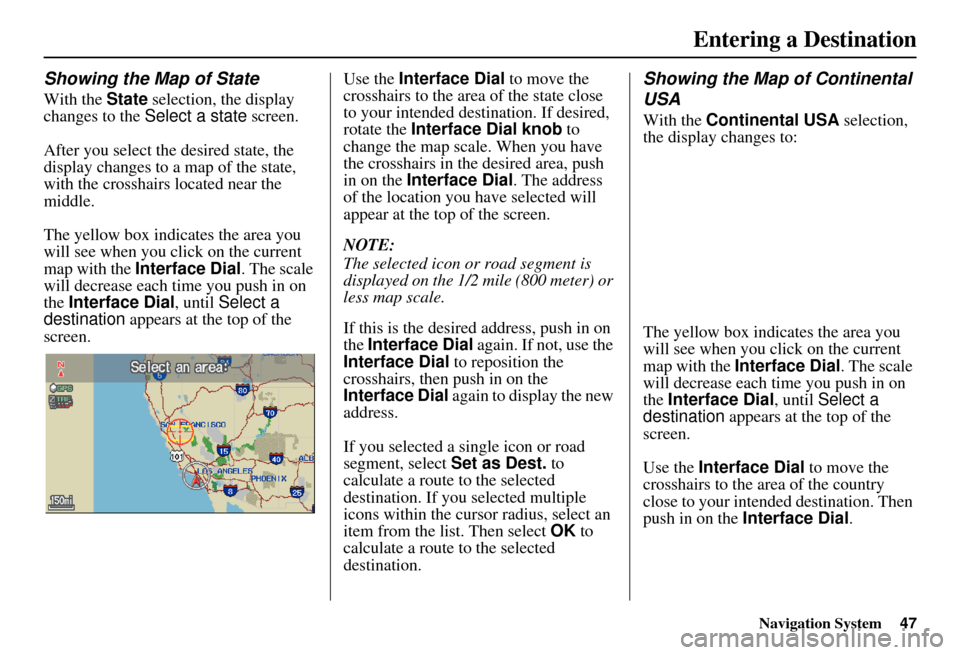
After you select the desired state, the
display changes to a map of the state,
with the crosshairs located near the
middle.
The yellow box indicat es the area you
will see when you click on the current
map with the Interface Dial . The scale
will decrease each time you push in on
the Interface Dial , until Select a
destination appears at the top of the
screen. Use the Interface Dial
to move the
crosshairs to the area of the state close
to your intended destination. If desired,
rotate the Interface Dial knob to
change the map scale. When you have
the crosshairs in the desired area, push
in on the Interface Dial . The address
of the location you have selected will
appear at the top of the screen.
NOTE:
The selected icon or road segment is
displayed on the 1/2 mile (800 meter) or
less map scale.
If this is the desired address, push in on
the Interface Dial again. If not, use the
Interface Dial to reposition the
crosshairs, then push in on the
Interface Dial again to display the new
address.
If you selected a single icon or road
segment, select Set as Dest. to
calculate a route to the selected
destination. If you selected multiple
icons within the cursor radius, select an
item from the list. Then select OK to
calculate a route to the selected
destination.
Showing the Map of Continental
USA
With the Continental USA selection,
the display changes to:
The yellow box indicates the area you
will see when you click on the current
map with the Interface Dial . The scale
will decrease each time you push in on
the Interface Dial , until Select a
destination appears at the top of the
screen.
Use the Interface Dial to move the
crosshairs to the area of the country
close to your intended destination. Then
push in on the Interface Dial .
Page 49 of 176
48Navigation System
Entering a Destination
If desired, rotate the Interface Dial
knob to change the map scale. When
you have the crosshairs on the desired
icon, map feature, or road, push in on
the Interface Dial . The address of the
location you have selected will appear at
the top of the screen.
NOTE:
The selected icon or road segment is
displayed on the 1/2 mile (800 meter) or
less map scale.
If this is the desired address, push in on
the Interface Dial again. If not, use the
Interface Dial to reposition the
crosshairs, then push in on the
Interface Dial again to display the new
address.
If you selected a single icon or road
segment, select Set as Dest. to
calculate a route to the selected
destination. If you selected multiple
icons within the cursor radius, select an
item from the list. Then select OK to
calculate a route to the selected
destination.By Today’s Destinations
You can create a “trip” by combining up
to five destinations previously selected
on the Calculate route to screen.
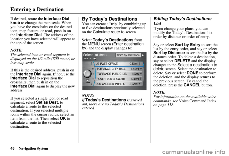
Select Today’s Destinations from
the MENU screen ( Enter destination
by ) and the display changes to:
NOTE:
If Today’s Destinations is grayed
out, there are no Today’s Destinations
entered.
Editing Today’s Destinations
List
If you change your plans, you can
modify the Today’s Destinations list
order by distance or order of entry.
Say or select Sort by Entry to sort the
list by the entry order, and say or select
Sort by Distance to sort the list by the
distance order. To delete a destination,
say or select DELETE and the display
changes to the Select a destination to
delete screen. Select the destination to
delete. Say or select DONE to perform
the deletion, and the display returns to
the previous screen . To cancel the
deletion, press the CANCEL button.
NOTE:
For information on the available voice
commands, see Voice Command Index
on page 158.
Page 50 of 176
Navigation System49
Entering a Destination
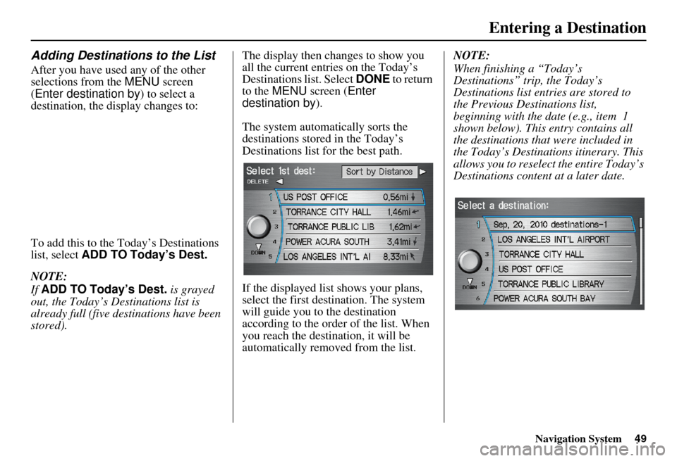
Adding Destinations to the List
After you have used any of the other
selections from the MENU screen
(Enter destination by ) to select a
destination, the di splay changes to:
To add this to the Today’s Destinations
list, select ADD TO Today’s Dest.
NOTE:
If ADD TO Today’s Dest. is grayed
out, the Today’s Destinations list is
already full (five destinations have been
stored). The display then changes to show you
all the current entr
ies on the Today’s
Destinations list. Select DONE to return
to the MENU screen ( Enter
destination by ).
The system automatically sorts the
destinations stored in the Today’s
Destinations list for the best path.
If the displayed list shows your plans,
select the first des tination. The system
will guide you to the destination
according to the order of the list. When
you reach the destination, it will be
automatically removed from the list. NOTE:
When finishing a “Today’s
Destinations” trip, the Today’s
Destinations list entries are stored to
the Previous Destinations list,
beginning with the date (e.g., item 1
shown below). This entry contains all
the destinations that
were included in
the Today’s Destinations itinerary. This
allows you to reselect the entire Today’s
Destinations content at a later date.
Page 51 of 176
50Navigation System
Entering a Destination
By Go Home
Selecting Go Home from the MENU
screen ( Enter destination by ) takes
you home or to a frequently used
address you have chosen.
If a Go Home PIN has been set, the
system prompts you to enter your PIN.
Say or enter your PIN. The system will
then display the Calculate route to
screen (see Driving to Your Destination
on page 51).
If a Go Home PIN has not been set, the
system displays the Calculate route to
screen after you select Go Home (see
Driving to Your Destination on
page 51). NOTE:
To edit Home Address, see
Home
Address in System Setup on page 97.
Prior to departure, you can set areas to avoid. The system then includes
them in its calculations for the
destination you have entered. See
Edit Avoid Area on page 105.
PINs are optional. If you choose to use a PIN, make sure you remember
it. If you forget your PIN, your dealer
will have to reset it for you.
If a PIN is desired, enter it using the Personal preference PIN number
feature in SETUP. See page 97 for
information on entering your PIN
number.
Page 52 of 176
Navigation System51
Driving to Your Destination
Driving to Your Destination
A route typically has three phases.
• Initial route calculation ( Calculate
route to screen) (see page 51).
• Change the route while en route (see page 73).
• Resume the route when restarting the engine (see Continue Trip Screen on
page 78).
Calculate Route to Screen
Say or select OK . The system calculates
the route using the method shown on the
screen (see Map Screen on page 54).
NOTE:
Prior to departure, you can set areas to avoid. The system then includes
them in its calculations for the
destination you have entered. See
Edit Avoid Area on page 105.
For information on the available voice commands, see Voice
Command Index on page 158. Further selections from the
Calculate
route to screen include:
ADD TO Address Book
Allows you to add the destination to
your Address Book. See By Address
Book on page 32.
NOTE:
If EDIT Address Book is displayed,
the destination is alre ady stored in your
Address Book. You can edit the address
in your Address Book by selecting this
button. For informatio n on editing your
Address Book, see Address Book on
page 93.
ADD TO Today’s Destinations
Allows you to add the destination to
your Today’s Destinations list. See By
Today’s Destinations on page 48.
NOTE:
If the button is grayed out, the Today’s
Destinations list is already full (five
destinations have been stored).
CALL
Dials the number on the screen when
available. See Bluetooth®
HandsFreeLink® on page 18.
Page 53 of 176
52Navigation System
Driving to Your Destination
Changing the Routing Method
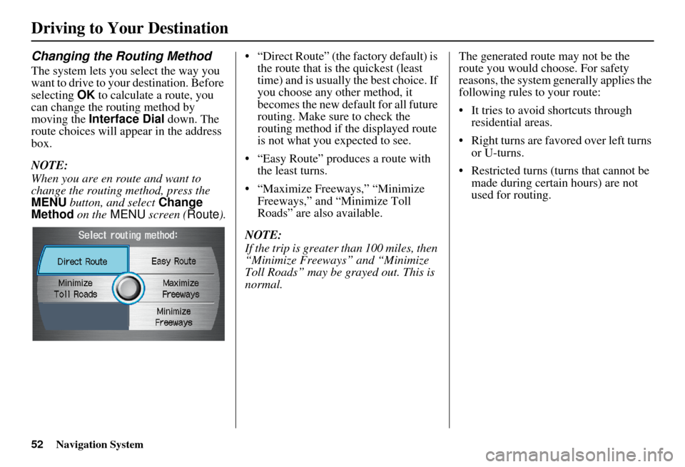
The system lets you select the way you
want to drive to your destination. Before
selecting OK to calculate a route, you
can change the routing method by
moving the Interface Dial down. The
route choices will appear in the address
box.
NOTE:
When you are en route and want to
change the routing method, press the
MENU button, and select Change
Method on the MENU screen ( Route).• “Direct Route” (the factory default) is
the route that is the quickest (least
time) and is usually the best choice. If
you choose any other method, it
becomes the new default for all future
routing. Make sure to check the
routing method if the displayed route
is not what you expected to see.
• “Easy Route” produces a route with the least turns.
• “Maximize Freeways,” “Minimize Freeways,” and “Minimize Toll
Roads” are also available.
NOTE:
If the trip is greater than 100 miles, then
“Minimize Freeways” and “Minimize
Toll Roads” may be grayed out. This is
normal. The generated route may not be the
route you would choose. For safety
reasons, the system generally applies the
following rules to your route:
• It tries to avoid shortcuts through
residential areas.
• Right turns are favored over left turns or U-turns.
• Restricted turns (turns that cannot be made during certain hours) are not
used for routing.
Page 54 of 176
Navigation System53
Viewing the Routes
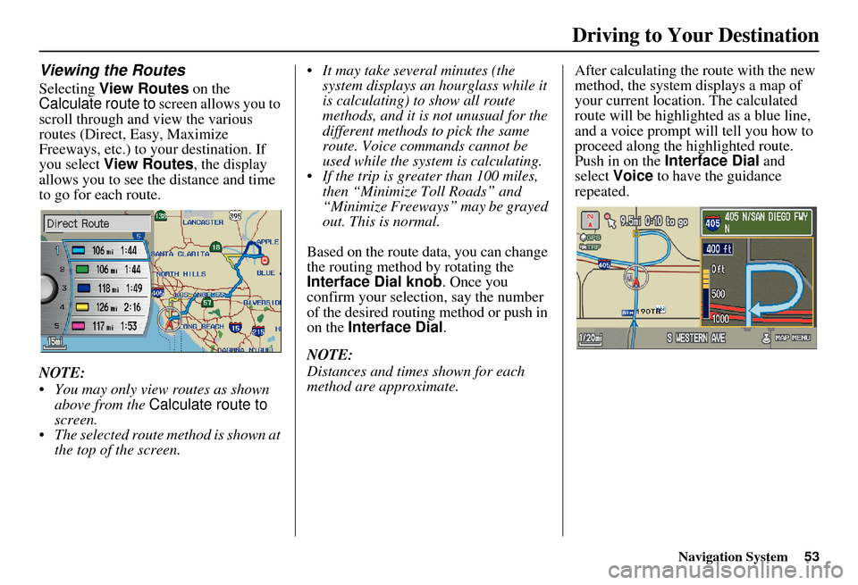
Selecting View Routes on the
Calculate route to screen allows you to
scroll through and view the various
routes (Direct, Easy, Maximize
Freeways, etc.) to your destination. If
you select View Routes , the display
allows you to see the distance and time
to go for each route.
NOTE:
You may only view routes as shown above from the Calculate route to
screen.
The selected route method is shown at the top of the screen. It may take several minutes (the
system displays an hourglass while it
is calculating) to show all route
methods, and it is not unusual for the
different methods to pick the same
route. Voice commands cannot be
used while the system is calculating.
If the trip is greater than 100 miles, then “Minimize Toll Roads” and
“Minimize Freeways” may be grayed
out. This is normal.
Based on the route data, you can change
the routing method by rotating the
Interface Dial knob. Once you
confirm your selection, say the number
of the desired routing method or push in
on the Interface Dial .
NOTE:
Distances and times shown for each
method are approximate. After calculating the route with the new
method, the system displays a map of
your current locatio
n. The calculated
route will be highlighted as a blue line,
and a voice prompt will tell you how to
proceed along the highlighted route.
Push in on the Interface Dial and
select Voice to have the guidance
repeated.
Driving to Your Destination
Page 55 of 176
54Navigation System
Driving to Your Destination
Viewing the Destination Map
Selecting View Dest. Map displays a
map of the destination vicinity. Press the
CANCEL or NAVI BACK button to
return. You can view the destination
map anytime while en route by saying,
“Display destination map.”
Map Screen
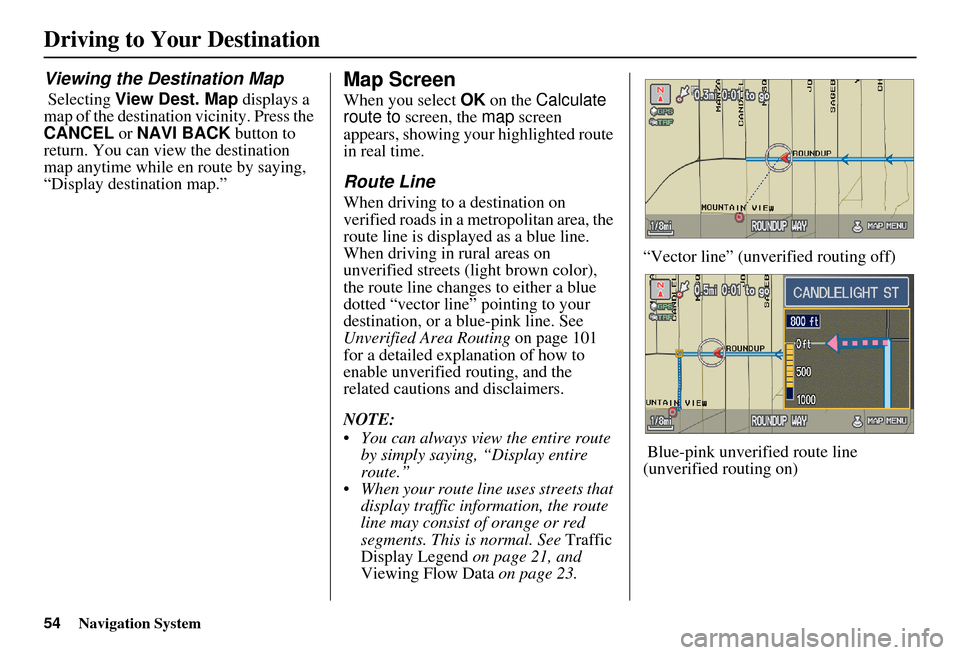
When you select OK on the Calculate
route to screen, the map screen
appears, showing your highlighted route
in real time.
Route Line
When driving to a destination on
verified roads in a metropolitan area, the
route line is displayed as a blue line.
When driving in rural areas on
unverified streets (light brown color),
the route line changes to either a blue
dotted “vector line” pointing to your
destination, or a blue-pink line. See
Unverified Area Routing on page 101
for a detailed explanation of how to
enable unverified routing, and the
related cautions and disclaimers.
NOTE:
You can always view the entire route by simply saying, “Display entire
route.”
When your route line uses streets that display traffic information, the route
line may consist of orange or red
segments. This is normal. See Traffic
Display Legend on page 21, and
Viewing Flow Data on page 23. “Vector line” (unverified routing off)
Blue-pink unverified route line
(unverified routing on)