Acuralink real-time traffic Acura RDX 2015 Navigation Manual
[x] Cancel search | Manufacturer: ACURA, Model Year: 2015, Model line: RDX, Model: Acura RDX 2015Pages: 258, PDF Size: 11.1 MB
Page 3 of 258
Quick Reference Guide
2
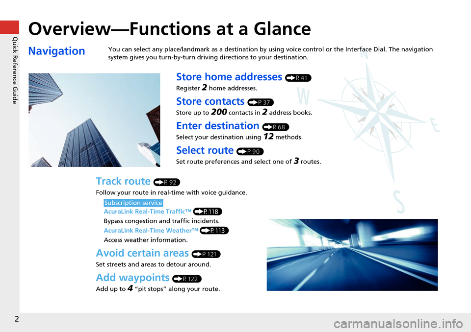
Overview—Functions at a Glance
NavigationYou can select any place/landmark as a destination by using voice control or the Interface Dial. The navigation
system gives you turn-by-turn driving directions to your destination.
Store home addresses (P41)
Register
2 home addresses.
Store contacts (P37)
Store up to
200 contacts in 2 address books.
Enter destination (P68)
Select your destination using
12 methods.
Select route (P90)
Set route preferences and select one of
3 routes.
Track route (P92)
Follow your route in real-time with voice guidance.
AcuraLink Real-Time Traffic™ (P118)
Bypass congestion an d traffic incidents.
AcuraLink Real-Time Weather™ (P113)
Access weather information.
Avoid certain areas (P121)
Set streets and areas to detour around.
Add waypoints (P122)
Add up to
4 “pit stops” along your route.
Subscription service
Page 16 of 258
15
Quick Reference GuideAcuraLink®
AcuraLink® Messages (P199)
AcuraLink® provides a direct communication link
between you and Acura. It sends and receives several
kinds of messages through SiriusXM® Radio, including:
Vehicle feature guide
Operating quick tips
Safety and maintenance information
Diagnostic information
Dealer appointment and maintenance reminders
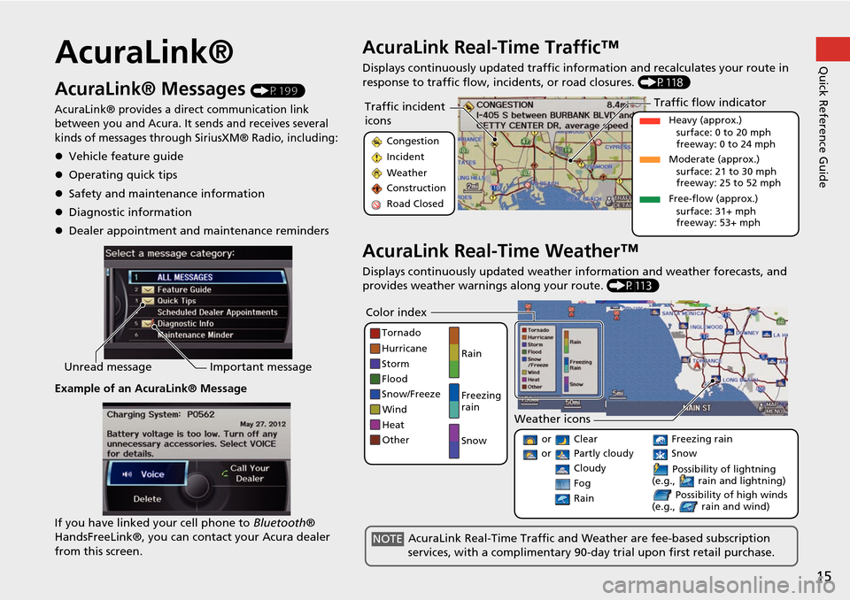
Example of an AcuraLink® Message
If you have linked your cell phone to Bluetooth®
HandsFreeLink®, you can contact your Acura dealer
from this screen.
Unread message Important message
AcuraLink Real-Time Traffic™
Displays continuously updated traffic info rmation and recalculates your route in
response to traffic flow, in cidents, or road closures. (P118)
AcuraLink Real-Time Weather™
Displays continuously updated weather information and weather forecasts, and
provides weather warnings along your route. (P113)
Traffic incident
icons
Congestion
Incident
Weather
Construction
Road Closed
Traffic flow indicator
Heavy (approx.)
surface: 0 to 20 mph
freeway: 0 to 24 mph
Moderate (approx.) surface: 21 to 30 mph
freeway: 25 to 52 mph
Free-flow (approx.) surface: 31+ mph
freeway: 53+ mph
Color index
Tornado
Hurricane
Storm
Flood
Snow/Freeze
Wind
Heat
Other Rain
Freezing
rain
Snow
Weather icons
or Clear
or Partly cloudy
Cloudy Possibility of lightning
(e.g., rain and lightning)
Possibility of high winds
(e.g., rain and wind) Fog
Rain
Freezing rain
Snow
AcuraLink Real-Time Traffic and Weather are fee-based subscription
services, with a complimentary 90-day trial upon first retail purchase.NOTE
Page 53 of 258
52
Routing & GuidanceTraffic Rerouting
System Setup
Traffic Rerouting
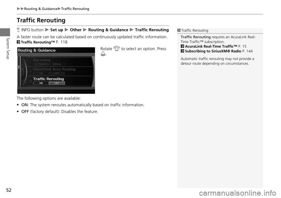
HINFO button Set up Other Routing & Guidance Traffic Rerouting
A faster route can be calculated based on continuously updated traffic information.
2Traffic Rerouting™ P. 118
Rotate i to select an option. Press
u .
The following options are available:
• ON : The system reroutes automati cally based on traffic information.
• OFF (factory default): Disables the feature.
1Traffic Rerouting
Traffic Rerouting requires an AcuraLink Real-
Time Traffic™ subscription.
2 AcuraLink Real-Time Traffic™ P. 15
2 Subscribing to SiriusXM® Radio P. 144
Automatic traffic rerouting may not provide a
detour route dependi ng on circumstances.
Page 90 of 258
89
Navigation
Calculating the Route
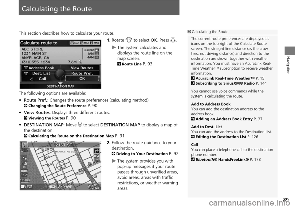
This section describes how to calculate your route.1.Rotate i to select OK. Press u.
The system calculates and
displays the route line on the
map screen.
2Route Line P. 93
The following options are available:
• Route Pref. : Changes the route preferences (calculating method).
2Changing the Route Preference P. 90
• View Routes : Displays three different routes.
2Viewing the Routes P. 90
• DESTINATION MAP : Move r to select DESTINATION MAP to display a map of
the destination.
2 Calculating the Route on the Destination Map P. 91
2. Follow the route guidance to your
destination.
2 Driving to Your Destination P. 92
The system provides you with
pop-up messages if your route
passes through unverified areas,
avoid areas, areas with traffic
restrictions, or weather warning
areas.
1Calculating the Route
The current route prefer ences are displayed as
icons on the top right of the Calculate Route
screen. The straight line distance (as the crow
flies, not driving distan ce) and direction to the
destination are shown t ogether with weather
information. You must have an AcuraLink Real-
Time Weather™ subscripti on to receive weather
information.
2 AcuraLink Real-Time Weather™ P. 15
2 Subscribing to SiriusXM® Radio P. 144
You cannot use voice commands while the
system is calculating the route.
Add to Address Book
You can add the destination address to the
address book.
2 Adding an Address Book Entry P. 37
Add to Dest. List
You can add the address to the Destination List.
2 Editing the Destination List P. 126
Call
You can place a telephone ca ll to the destination
phone number.
2 Bluetooth ® HandsFreeLink® P. 178
Page 94 of 258
93
Driving to Your DestinationViewing the Route
Navigation
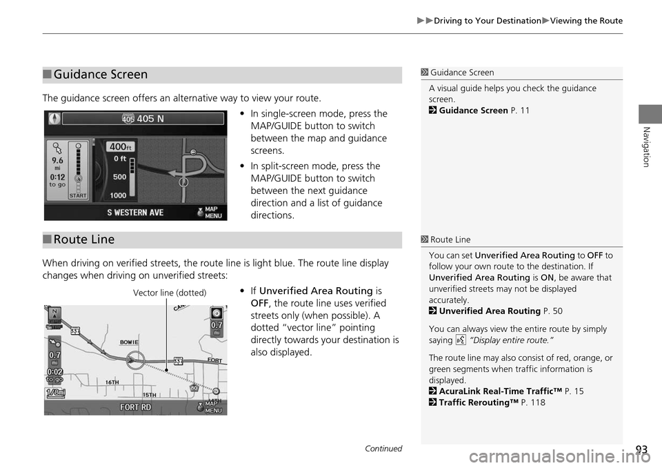
The guidance screen offers an alternative way to view your route.
•In single-screen mode, press the
MAP/GUIDE button to switch
between the map and guidance
screens.
• In split-screen mode, press the
MAP/GUIDE button to switch
between the next guidance
direction and a list of guidance
directions.
When driving on verified streets, the rout e line is light blue. The route line display
changes when driving on unverified streets:
•If Unverified Area Routing is
OFF , the route line uses verified
streets only (when possible). A
dotted “vector line” pointing
directly towards your destination is
also displayed.
■ Guidance Screen1 Guidance Screen
A visual guide helps you check the guidance
screen.
2 Guidance Screen P. 11
■Route Line1 Route Line
You can set Unverified Area Routing to OFF to
follow your own route to the destination. If
Unverified Area Routing is ON , be aware that
unverified streets ma y not be displayed
accurately.
2 Unverified Area Routing P. 50
You can always view the entire route by simply
saying d “Display entire route.”
The route line may also c onsist of red, orange, or
green segments when traffic information is
displayed.
2 AcuraLink Real-Time Traffic™ P. 15
2 Traffic Rerouting™ P. 118
Vector line (dotted)
Continued
Page 98 of 258
97
Navigation
Map Menu
Displaying the Map Menu
Use the Map Menu to control the icons displayed on the screen and to display traffic
information, weather information, and messa ges. You can also use the Map Menu
to find locations or to cancel the route.
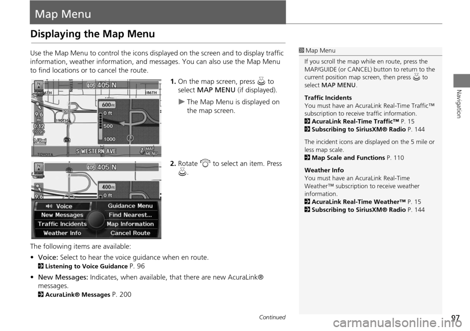
1.On the map screen, press u to
select MAP MENU (if displayed).
The Map Menu is displayed on
the map screen.
2. Rotate i to select an item. Press
u .
The following items are available:
• Voice: Select to hear the voice guidance when en route.
2Listening to Voice Guidance P. 96
• New Messages: Indicates, when available, that there are new AcuraLink®
messages.
2 AcuraLink® Messages P. 200
1Map Menu
If you scroll the map while en route, press the
MAP/GUIDE (or CANCEL) button to return to the
current position map screen, then press u to
select MAP MENU .
Traffic Incidents
You must have an AcuraL ink Real-Time Traffic™
subscription to receive traffic information.
2 AcuraLink Real-Time Traffic™ P. 15
2 Subscribing to SiriusXM® Radio P. 144
The incident icons are displayed on the 5 mile or
less map scale.
2 Map Scale and Functions P. 110
Weather Info
You must have an AcuraLink Real-Time
Weather™ subscription to receive weather
information.
2 AcuraLink Real-Time Weather™ P. 15
2 Subscribing to SiriusXM® Radio P. 144
Continued
Page 106 of 258
105
Map MenuMap Information
Navigation
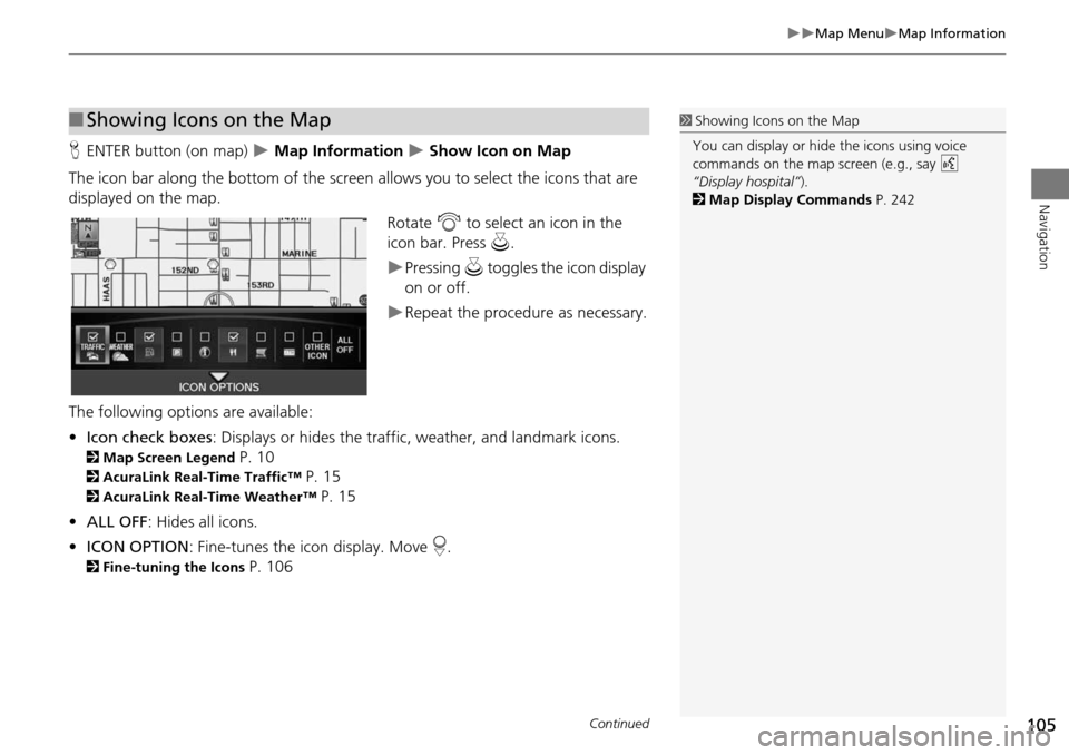
HENTER button (on map) Map Information Show Icon on Map
The icon bar along the bottom of the screen allows you to select the icons that are
displayed on the map. Rotate i to select an icon in the
icon bar. Press u.
Pressing u toggles the icon display
on or off.
Repeat the procedure as necessary.
The following options are available:
• Icon check boxes : Displays or hides the traffic, weather, and landmark icons.
2Map Screen Legend P. 10
2AcuraLink Real-Time Traffic™ P. 15
2AcuraLink Real-Time Weather™ P. 15
• ALL OFF: Hides all icons.
• ICON OPTION : Fine-tunes the icon display. Move r.
2 Fine-tuning the Icons P. 106
■Showing Icons on the Map1 Showing Icons on the Map
You can display or hide the icons using voice
commands on the map screen (e.g., say d
“Display hospital” ).
2 Map Display Commands P. 242
Continued
Page 110 of 258
109
Map MenuMap Information
Navigation
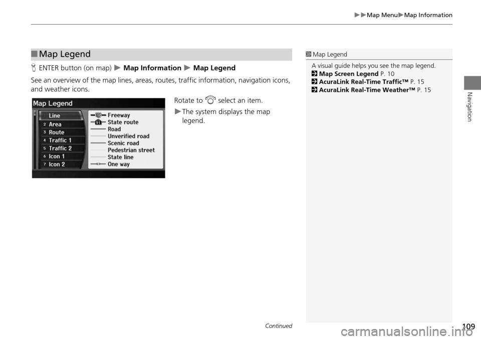
HENTER button (on map) Map Information Map Legend
See an overview of the map lines, areas, ro utes, traffic information, navigation icons,
and weather icons.
Rotate to i select an item.
The system displays the map
legend.
■Map Legend1 Map Legend
A visual guide helps you see the map legend.
2 Map Screen Legend P. 10
2 AcuraLink Real-Time Traffic™ P. 15
2 AcuraLink Real-Time Weather™ P. 15
Continued
Page 114 of 258
113
Map MenuWeather Information
Navigation
Weather Information
HENTER button (on map) Weather Info
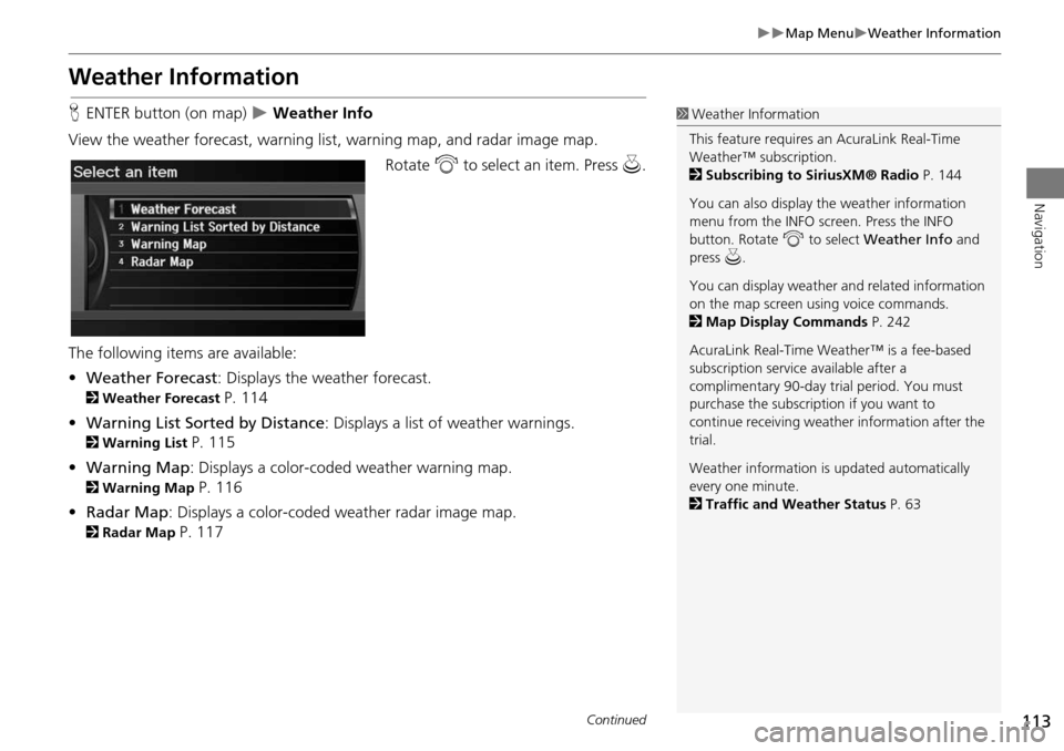
View the weather forecast, warning lis t, warning map, and radar image map.
Rotate i to select an item. Press u.
The following items are available:
• Weather Forecast : Displays the weather forecast.
2Weather Forecast P. 114
• Warning List Sorted by Distance : Displays a list of weather warnings.
2Warning List P. 115
• Warning Map : Displays a color-coded weather warning map.
2Warning Map P. 116
• Radar Map : Displays a color-coded weather radar image map.
2Radar Map P. 117
1Weather Information
This feature requires an AcuraLink Real-Time
Weather™ subscription.
2 Subscribing to SiriusXM® Radio P. 144
You can also display the weather information
menu from the INFO screen. Press the INFO
button. Rotate i to select Weather Info and
press u.
You can display weather and related information
on the map screen using voice commands.
2 Map Display Commands P. 242
AcuraLink Real-Time Weather™ is a fee-based
subscription service available after a
complimentary 90-day tr ial period. You must
purchase the subscription if you want to
continue receivi ng weather information after the
trial.
Weather information is updated automatically
every one minute.
2 Traffic and Weather Status P. 63
Continued
Page 119 of 258
118
Map MenuTraffic Rerouting™
Navigation
Traffic Rerouting™
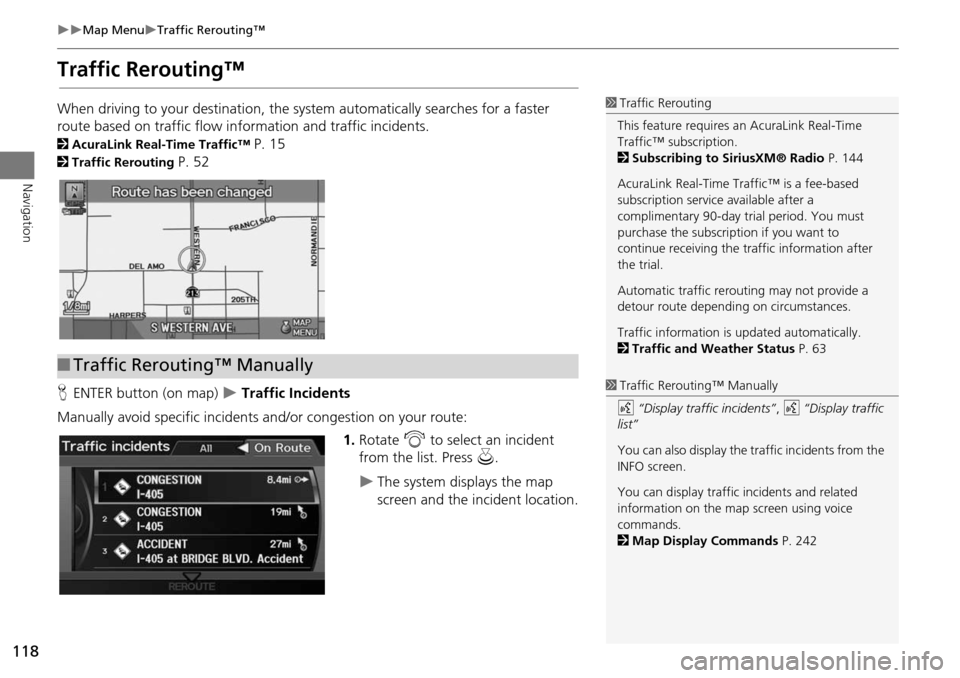
When driving to your destination, the system automatically searches for a faster
route based on traffic flow in formation and traffic incidents.
2AcuraLink Real-Time Traffic™ P. 15
2Traffic Rerouting P. 52
H ENTER button (on map)
Traffic Incidents
Manually avoid specific incidents and/or congestion on your route: 1.Rotate i to select an incident
from the list. Press u.
The system displays the map
screen and the incident location.
1Traffic Rerouting
This feature requires an AcuraLink Real-Time
Traffic™ subscription.
2 Subscribing to SiriusXM® Radio P. 144
AcuraLink Real-Time Traffic™ is a fee-based
subscription service available after a
complimentary 90-day tr ial period. You must
purchase the subscription if you want to
continue receiving the traffic information after
the trial.
Automatic traffic rerouting may not provide a
detour route dependi ng on circumstances.
Traffic information is updated automatically.
2 Traffic and Weather Status P. 63
■Traffic Rerouting™ Manually
1 Traffic Rerouting™ Manually
d “Display traffic incidents” , d “Display traffic
list”
You can also display the tr affic incidents from the
INFO screen.
You can display traffic incidents and related
information on the map screen using voice
commands.
2 Map Display Commands P. 242