tow Acura TL 2009 Navigation Manua
[x] Cancel search | Manufacturer: ACURA, Model Year: 2009, Model line: TL, Model: Acura TL 2009Pages: 172, PDF Size: 16.82 MB
Page 7 of 172

Introduction
Navigation System7
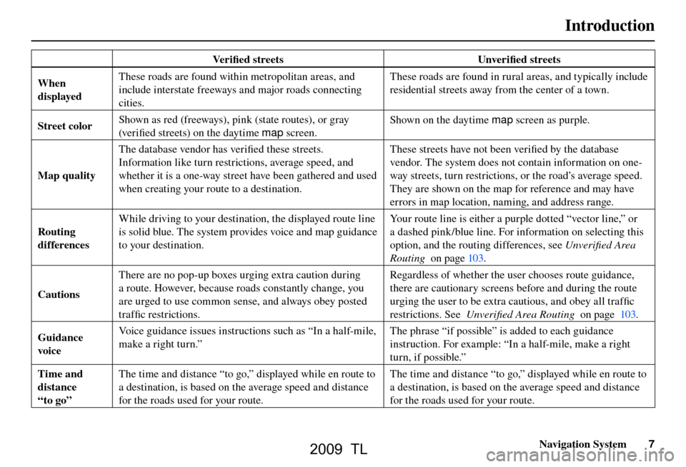
Ve r i fi ed streets Unverifi ed streets
When
displayed These roads are found within metropolitan areas, and
include interstate freeways and major roads connecting
cities. These roads are found in rural areas, and typically include
residential streets away from the center of a town.
Street color Shown as red (freeways), pink (state routes), or gray
(ver i fi
ed streets) on the daytime map screen. Shown on the daytime
map screen as purple.
Map quality The database vendor has verifi
ed these streets.
Information like turn restrictions, average speed, and
whether it is a one-way street have been gathered and used
when creating your route to a destination. These streets have not been verifi
ed by the database
vendor. The system does not contain information on one-
way streets, turn restrictions, or the road’s average speed.
They are shown on the map for reference and may have
errors in map location, naming, and address range.
Routing
differences While driving to your destination, the displayed route line
is solid blue. The system provides voice and map guidance
to your destination.
Your route line is either a purple dotted “vector line,” or
a dashed pink/blue line. For information on selecting this
option, and the routing differences, see
Unverifi ed Area
Routing on page 103 .
Cautions There are no pop-up boxes urging extra caution during
a route. However, because roads constantly change, you
are urged to use common sense, and always obey posted
traffi
c restrictions. Regardless of whether the user chooses route guidance,
there are cautionary screens before and during the route
urging the user to be extra cautious, and obey all traffi
c
restrictions. See Unverifi ed Area Routing on page 103 .
Guidance
voice Voice guidance issues instructions such as “In a half-mile,
make a right turn.”
The phrase “if possible” is added to each guidance
instruction. For example: “In a half-mile, make a right
turn, if possible.”
Time and
distance
“to go” The time and distance “to go,” displayed while en route to
a destination, is based on the average speed and distance
for the roads used for your route.
The time and distance “to go,” displayed while en route to
a destination, is based on the average speed and distance
for the roads used for your route.
2009 TL
Page 31 of 172

Entering a Destination
Navigation System31
The system has a talk back function.
If your spoken letter is not recognized,
the system will talk back to you. For
example, if you say “E” but the system
does not recognize the command, it
will ask you, “Please select the number
of the input letter from the list”, and the
following pop-up box will appear:
You should select a letter by saying the
number.
Alternatively, to improve voice
recognition, you can say “Echo” or
“Edward” instead of “E.” See pag e 17
for a list of available words for each
letter.
By Interface Dial:
Select City, and the display then
changes to the Enter city name screen. Tip:
After the display has been changed
to the
Enter city name screen, the
name of the city where your vehicle is
currently located will be displayed.
Vehicle position may not be displayed
when the automobile is traveling off
road or when vehicle position data
cannot be updated. In these situations,
you can select the City that is currently
displayed and conduct a Street search
by moving the Interface Dial down.
Use the Interface Dial to enter the
name of the city.
The system will display a list of city
names, with the closest match to the
name you entered at the top of the list.
Select the number (1-6) of the desired
city from the list.
You can also enter part of the name and
look for the name you want from the
list that appears.
Tip:
For name input, you don’t need to enter
spaces and symbols (& , -, % , etc.) .
The system is also enabled for partial
match searches. For example, when
you search “LOS ANGELES,” it is on
the list of search results if you input
“LOS” or “ANGELES.”
Listings of cities and towns in the non-
deta iled coverage a rea may have a n
asterisk “*” next to their names. If you
select one, a pop-up box is displayed
saying, “No detailed street data...”,
and a street address cannot be entered
(see Map Coverage on page 130 ). Try
entering the street fi rst, and then select
the city if available.
2009 TL
Page 133 of 172

Coverage Areas
Navigation System133
New Jersey
Northern New Jersey
Southern New Jersey – including Atlantic City/Cape May/
Cumberland Metro
Camden Metro
Newark Metro
Trenton Metro – including Ocean and Hunterdon Counties
New Mexico Albuquerque
Santa Fe
Taos Ski Resorts
New York The Adirondack
Binghamton
Buffalo – including Erie and Niagara Counties
Cooperstown
Eastern New York – including New York City Metro, Albany, Glen
Falls, Schenectady, Troy
Ithaca
Lake Placid
Oneonta
Rochester – including cities in Monroe County
Syracuse
Utica North Carolina
Asheville
Charlotte Metro
Fayetteville
Hickory
Morgantown
Jacksonville
North Carolina Metro
Raleigh-Durham Metro
Wilmington
Winston-Salem/Greensboro Metro
North Dakota Fargo Metro
Fa rgo-Moorhead
Ohio Akron
Columbus/Marysville Metro
Cincinnati Metro – including Butler County
Cleveland Metro – including Geauga County
Dayton
Toledo (Lucas County)
Yo u n g s t o w n
Oklahoma Oklahoma City
Tu l s a Oregon
Bend
Eugene
Medford
Portland /Salem Metro
Pennsylvania Allentown
Erie
Gettysburg
Harrisburg
Lancaster
Philadelphia Metro
Pittsburgh Metro – including Washington County
Reading
State College /University Park
Southern Pennsylvania
Wilkes-Barre /Scranton
Williamsport
Yo r k
Rhode Island Newport
Providence Metro
2009 TL
Page 137 of 172

Coverage Areas
Navigation System137
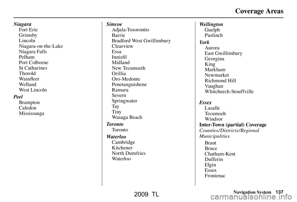
Niagara
Fort Erie
Grimsby
Lincoln
Niagara-on-the-Lake
Niagara Falls
Pelham
Port Colborne
St Catharines
Thorold
Wa i n fl eet
Wel l a n d
We s t L i n c ol n
Peel Brampton
Caledon
Mississauga Simcoe
Adjala-Tosorontio
Bar rie
Bradford West Gwillimbury
Clearview
Essa
Innisfi l
Midland
New Tecumseth
Orillia
Oro-Medonte
Penetanguishene
Ramara
Severn
Springwater
Tay
Tiny
Wa s a g a B e a c h
To r o n t o To r o n t o
Waterloo Cambridge
Kitchener
North Dumfries
Wa t e r l o o Wel l i ngt on
Guelph
Puslinch
Yo r k Aurora
East Gwillimbury
Georgina
King
Markham
Newmarket
Richmond Hill
Va u g h a n
Whitchurch-Stouffville
Essex Lasalle
Te c u m s e h
Windsor
Inter-Town (partial) Coverage
Counties /Districts / Regional
Municipalities
Brant
Bruce
Chatham-Kent
Dufferin
Elgin
Essex
Frontenac
2009 TL
Page 140 of 172

Coverage Areas
140 Navigation System
Roads in the province of Alberta
Hwy-1/Trans Canada Hwy across whole
province
Hwy-1A from Cochrane to Canmore
Hwy-1X from Hwy-1A to Hwy-1/ Trans Canada Hwy
Morley Road from Hwy-1/Trans Canada Hwy
Hwy-3/Crowsnest Hwy (at Medicine Hat) to Lethbridge
Hwy-4 (at Lethbridge) to 1-15 (U.S. border)
Hwy-36 between Hwy-3 (in Taber) and Hwy-4 (in Warner)
Hwy-3/Crowsnest Hwy (in Lethbridge) to Hwy-2 (in Fort Macleod)
Hwy-2 (in Fort Macleod) to Hwy-1/ Trans Canada Hwy (in Calgary)
Roads in the province of Saskatchewan
Hwy-1/Trans Canada Hwy across whole province Roads in the province of Manitoba
Hwy-1/Trans Canada Hwy across whole
province
Hwy-100/Trans Canada Hwy in Winnipeg (partial beltway)
Hwy-75 from Hwy-100/Trans Canada Hwy (Winnipeg) south to link with
1-29 ( U. S. b ord er)
Roads in the province of Ontario
Hwy-69/Trans Canada Hwy from Muskoka district to Sudbury
Hwy-17/Trans Canada Hwy from Ottawa Detailed Area Coverage to
Manitoba border
Hwy-17B at Sault Ste Marie to link with 1-75 (U.S. border)
Hwy-61 from Hwy-17 at Thunder Bay to link with US-61 (U.S. border)
Hwy-11 from Muskoka district to North Bay
Hwy-60 and Hwy-127 in Nipissing County Cities with available real-time in-car
traffi
c information
The following cities currently have
available real-time traffi c information.
In the U.S. Albany-Schenectady-Troy, NY
Albuquerque, NM
Allentown-Bethlehem, PA
Atlanta, GA
Austin, TX
Baltimore, MD
Bir m ingham, A L
Boston, MA
Buffalo-Niagara Falls, NY
Charlotte-Gastonia-Rock Hill, NC
Chicago, IL
Cincinnati, OH
Cleveland, OH
Colorado Springs, CO
Columbus, OH
Dallas-Ft. Worth, TX
Dayton, OH
Denver-Boulder, CO
Detroit, MI
Fresno, CA
Grand Rapids, MI
Gr eensboro-Winston Salem-High Point, NC
Greenville-Spartanburg, SC
Harrisburg-Lebanon-Carlisle, PA
2009 TL
Page 141 of 172

Coverage Areas
Navigation System141
Hartford-New Britain-Middletown, CT
Houston-Galveston, TX
Indianapolis, IN
Jacksonville, F L
Kansas City, KS
Lancaster-York, PA
Las Vegas, NV
Lincoln, NE
Little Rock, AR
Los Angeles, CA
Louisville, KY
Memphis, TN
Miami-Ft. Lauderdale-Hollywood, FL
Milwaukee-Racine, WI
Minneapolis-St. Paul, MN
Mobile, AL
Naples-Ft. Myers, FL
Nashville, TN
New Orleans, LA
New York, NY
No rfolk-Virginia Beach-Newport
News, VA
Oklahoma City, OK
Omaha-Council Bluffs, NE
Orlando, FL
Philadelphia, PA
Phoenix, AZ
Pittsburgh, PA
Portland, OR
Portsmouth-Manchester, NH Providence-Warwick-Pawtucket, RI
Raleigh-Durham, NC
Richmond, VA
Rochester, NY
Sacramento, CA
Salt Lake City, UT
San Antonio, TX
San Diego, CA
San Francisco-Oakland, CA
San Jose, CA
Sarasota-Bradenton, FL
Seattle-Tacoma, WA
Spokane, WA
Springfi
eld, MA
St. Louis, MO
Syracuse, NY
Tampa-St. Petersburg-Clearwater, FL
To l e d o , O H
Tu c s o n , A Z
Tu l s a , O K
Washington, DC
West Palm Beach-Boca Raton, FL
Wilkes Barre-Scranton, PA
Wilmington, DE
In Canada To r o n t o , O N
Montreal, QB
Va n c o u v e r, B C Coverage may expand to other
cities as traffi
c information in
those cities becomes available. For
the latest traffi c coverage details
for each metropolitan area, check
www.acura.com /realtimetraffi c . This
site provides traffi c coverage for each
city, a demonstation video, and FAQs.
2009 TL
Page 142 of 172

Coverage Areas
142 Navigation System
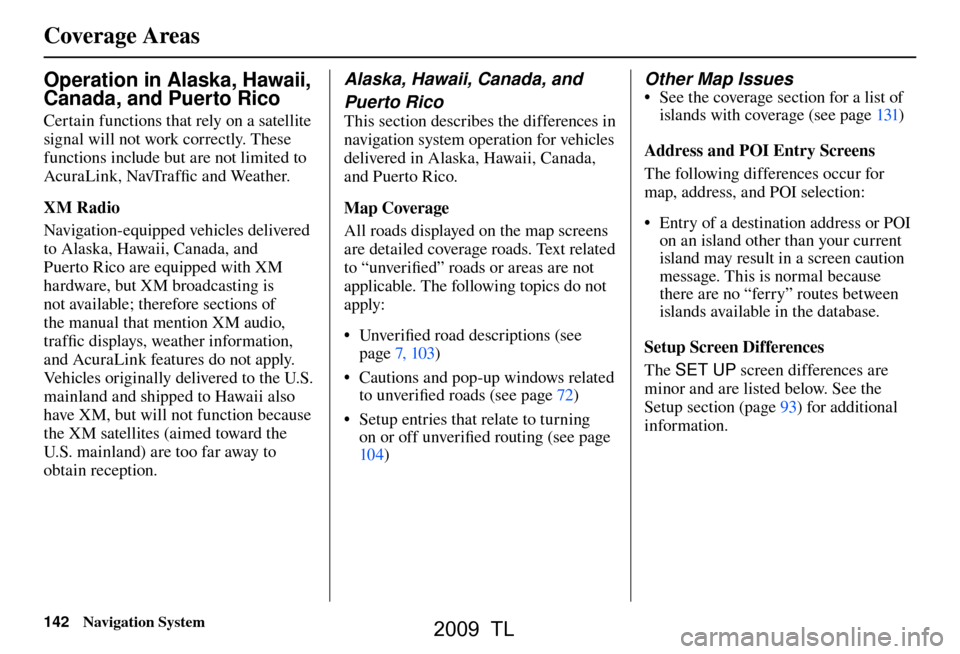
Operation in Alaska, Hawaii,
Canada, and Puerto Rico
Certain functions that rely on a satellite
signal will not work correctly. These
functions include but are not limited to
AcuraLink, NavTraffi c and Weather.
XM Radio
Navigation-equipped veh icles delivered
to Alaska, Hawaii, Canada, and
Puerto Rico are equipped with XM
hardware, but XM broadcasting is
not available; therefore sections of
the manual that mention XM audio,
traffi c displays, weather information,
and AcuraLink features do not apply.
Vehicles originally delivered to the U.S.
mainland and shipped to Hawaii also
have XM, but will not function because
the XM satellites (aimed toward the
U.S. mainland) are too far away to
obtain reception.
Alaska, Hawaii, Canada, and
Puerto Rico
This section describes the differences in
navigation system operation for vehicles
delivered in Alaska, Hawaii, Canada,
and Puerto Rico.
Map Coverage
All roads displayed on the map screens
are detailed coverage roads. Text related
to “unverifi ed” roads or areas are not
applicable. The following topics do not
apply:
• Unverifi ed road descriptions (see
page 7, 103 )
• Cautions and pop-up windows related to unverifi ed roads (see page 72 )
• Setup entries that relate to turning on or off unverifi ed routing (see page
10 4 )
Other Map Issues
• See the coverage section for a list of
islands with coverage (see page 131 )
Address and POI Entry Screens
The following differences occur for
map, address, and POI selection:
• Entry of a destination address or POI on an island other than your current
island may result in a screen caution
message. This is normal because
there are no “ferry” routes between
islands available in the database.
Setup Screen Differences
The SET UP screen differences are
minor and are listed below. See the
Setup section (pag e 93 ) for additional
information.
2009 TL
Page 155 of 172

Glossary
Navigation System155
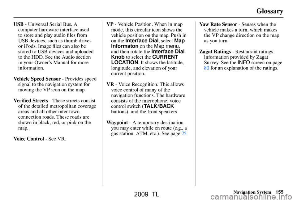
USB - Universal Serial Bus. A
computer hardware interface used
to store and play audio fi les from
USB devices, such as thumb drives
or iPods. Image fi les can also be
stored to USB devices and uploaded
to the HDD. See the Audio section
in your Owner’s Manual for more
information.
Vehicle Speed Sensor - Provides speed
signal to the navigation system for
moving the VP icon on the map.
Ve r i fi ed Streets - These streets consist
of the detailed metropolitan coverage
areas and all other inter-town
connection roads. These roads are
shown in black, red, or pink on the
map.
Voice Control - See VR. VP
- Vehicle Position. When in map
mode, this circular icon shows the
vehicle position on the map. Push in
on the Interface Dial , select Map
Informaton on the Map menu ,
and then rotate the Interface Dial
Knob to select the CURRENT
LOCATION . It shows the latitude,
longitude, and elevation of your
current position.
VR - Voice Recognition. This allows
voice control of many of the
navigation functions. The hardware
consists of the microphone, voice
control switch ( TA L K/BACK
buttons), and the front speakers.
Way p o i nt - A temporary destination
you may enter while en route (e.g., a
gas station, ATM, etc.). See page 75 . Yaw R a t e S e n s o r
- Senses when the
vehicle makes a turn, which makes
the VP change direction on the map
as you turn.
Zagat Ratings - Restaurant ratings
information provided by Zagat
Survey. See the INFO screen on page
80 f or an explanation of the ratings.
2009 TL