sat nav BMW 7 SERIES 2001 E38 Mk3 Navigation System Manual
[x] Cancel search | Manufacturer: BMW, Model Year: 2001, Model line: 7 SERIES, Model: BMW 7 SERIES 2001 E38Pages: 17, PDF Size: 1.33 MB
Page 5 of 17

5
Mk-3 navigation
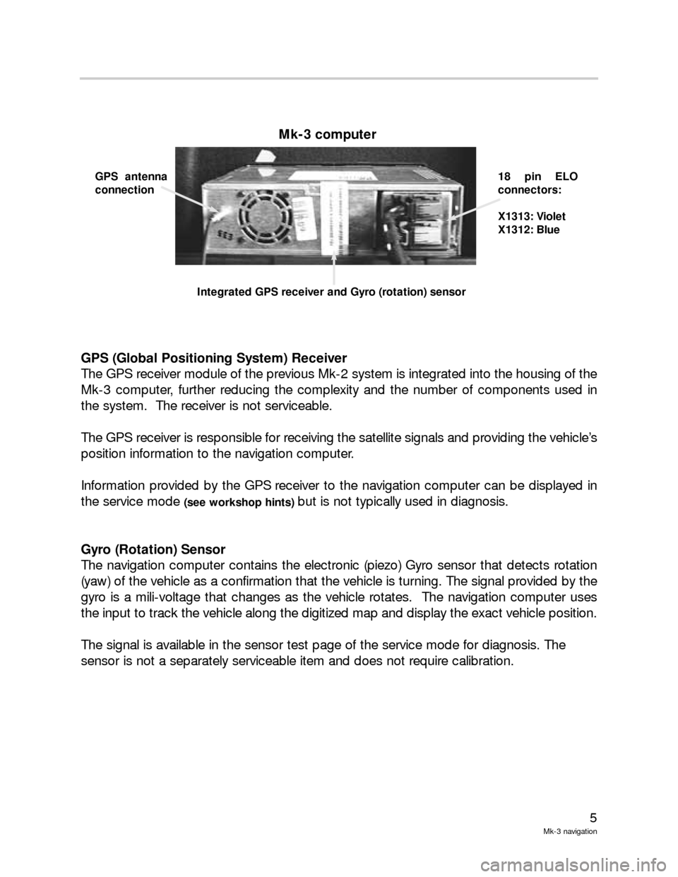
GPS (Global Positioning System) Receiver
The GPS receiver module of the previous Mk-2 system is integrated into the housing of the
Mk-3 computer, further reducing the complexity and the number of components used in
the system. The receiver is not serviceable.
The GPS receiver is responsible for receiving the satellite signals and providing the vehicle’s
position information to the navigation computer.
Information provided by the GPS receiver to the navigation computer can be displayed in
the service mode
(see workshop hints) but is not typically used in diagnosis.
Gyro (Rotation) Sensor
The navigation computer contains the electronic (piezo) Gyro sensor that detects rotation
(yaw) of the vehicle as a confirmation that the vehicle is turning. The signal provided by the
gyro is a mili-voltage that changes as the vehicle rotates. The navigation computer uses
the input to track the vehicle along the digitized map and display the exact vehicle position.
The signal is available in the sensor test page of the service mode for diagnosis. The
sensor is not a separately serviceable item and does not require calibration.
Mk-3 computer
GPS antenna
connection18 pin ELO
connectors:
X1313: Violet
X1312: Blue
Integrated GPS receiver and Gyro (rotation) sensor
Page 10 of 17

10
Mk-3 Navigation
Principle of Operation
The Global Positioning System is a satellite based system developed by the US Department
of Defense that provides both military and civilian users accurate information about
location.
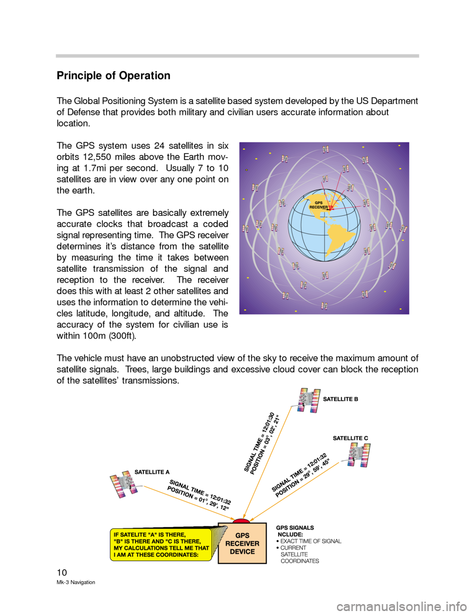
The GPS system uses 24 satellites in six
orbits 12,550 miles above the Earth mov-
ing at 1.7mi per second. Usually 7 to 10
satellites are in view over any one point on
the earth.
The GPS satellites are basically extremely
accurate clocks that broadcast a coded
signal representing time. The GPS receiver
determines it’s distance from the satellite
by measuring the time it takes between
satellite transmission of the signal and
reception to the receiver. The receiver
does this with at least 2 other satellites and
uses the information to determine the vehi-
cles latitude, longitude, and altitude. The
accuracy of the system for civilian use is
within 100m (300ft).
The vehicle must have an unobstructed view of the sky to receive the maximum amount of
satellite signals. Trees, large buildings and excessive cloud cover can block the reception
of the satellites’ transmissions.
Page 14 of 17

14
Mk-3 Navigation
Service Mode
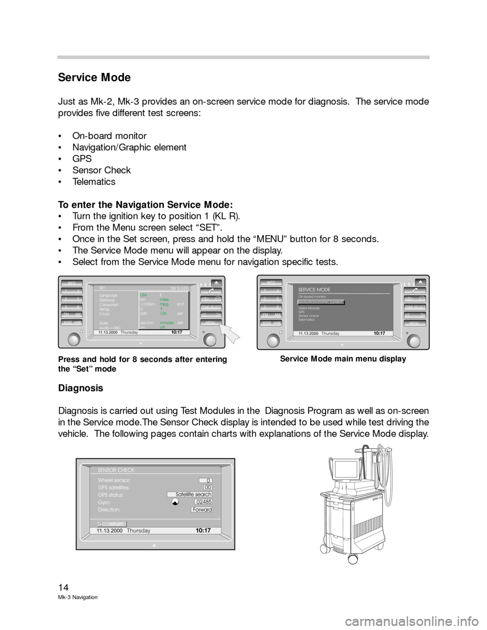
Just as Mk-2, Mk-3 provides an on-screen service mode for diagnosis. The service mode
provides five different test screens:
On-board monitor
Navigation/Graphic element
GPS
Sensor Check
Telematics
To enter the Navigation Service Mode:
Turn the ignition key to position 1 (KL R).
From the Menu screen select “SET”.
Once in the Set screen, press and hold the “MENU” button for 8 seconds.
The Service Mode menu will appear on the display.
Select from the Service Mode menu for navigation specific tests.
Diagnosis
Diagnosis is carried out using Test Modules in the Diagnosis Program as well as on-screen
in the Service mode.The Sensor Check display is intended to be used while test driving the
vehicle. The following pages contain charts with explanations of the Service Mode display.
11.13.2000Thursday10 : 17
INFO
1
4
25
36
FM AM
MODEMENU
TONE SELECT
Language
Distance
Consumpt.
Temp.
Clock
Date
Audio+OBCUSA
miles
mpg
F
12h
mm/dd
off E
km
1/100km km/l
C
24h set
dd.mm set
onSW 3-1/20 SET
11.13.2000Thursday10:17
INFO
1
4
25
36
FM AM
MODEMENU
TONE SELECT
On-board monitor
Video Module
GPS
Sensor check
TelematicsNAVIGATION/GRAPHIC ELEMENT
SERVICE MODE
Press and hold for 8 seconds after entering
the “Set” modeService Mode main menu display
BMWDISB
M
WD
IS
BMWDISB
M
WD
IS
11.13.2000Thursday10 : 17
Wheel sensor:
GPS satellites:
GPS status:
Gyro:
Direction: SENSOR CHECK
return
0
00
Satellite search
02485
Forward
Page 16 of 17

16
Mk-3 Navigation
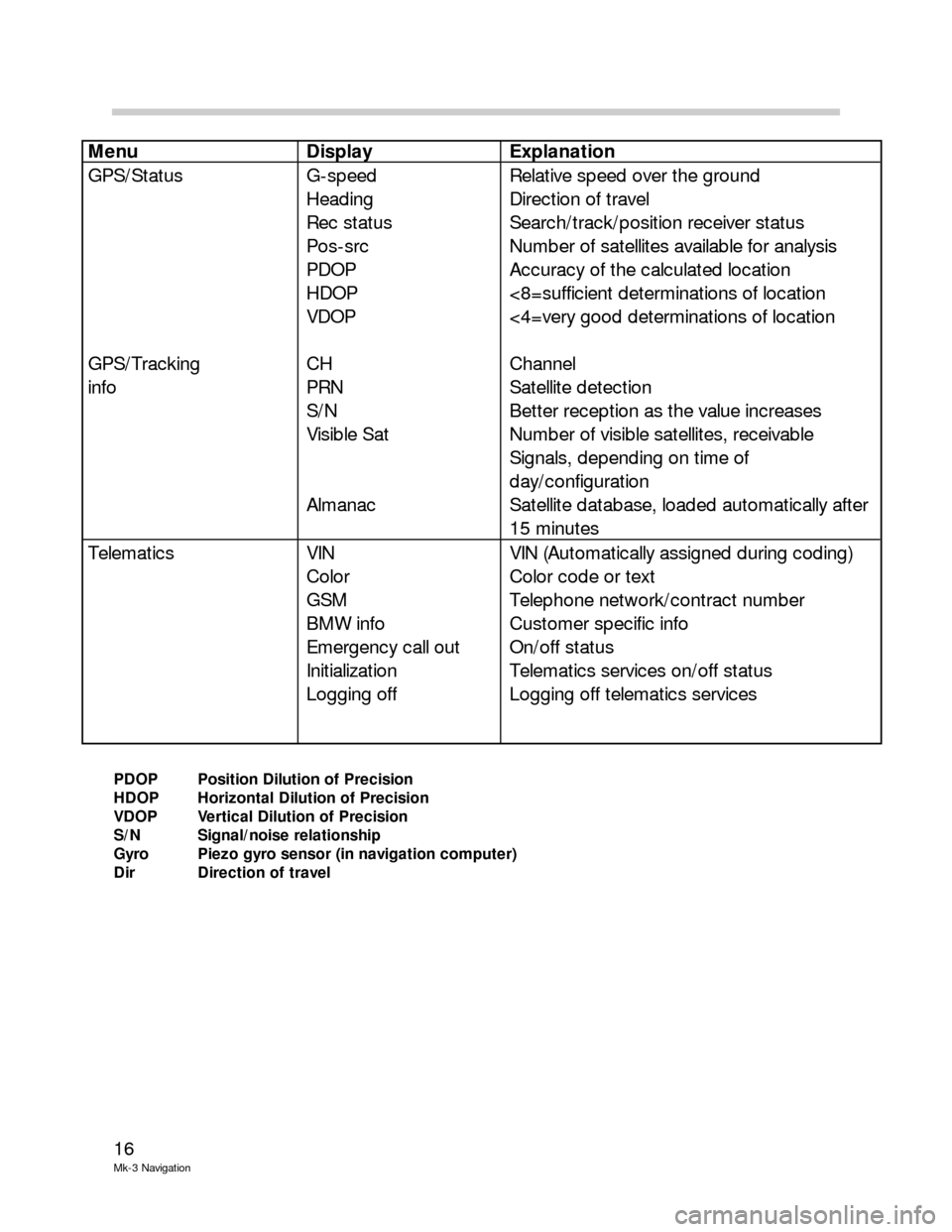
PDOP Position Dilution of Precision
HDOP Horizontal Dilution of Precision
VDOP Vertical Dilution of Precision
S/N Signal/noise relationship
Gyro Piezo gyro sensor (in navigation computer)
Dir Direction of travel
Menu Display Explanation
GPS/Status
GPS/Tracking
info G-speed
Heading
Rec status
Pos-src
PDOP
HDOP
VDOP
CH
PRN
S/N
Visible Sat
Almanac Relative speed over the ground
Direction of travel
Search/track/position receiver status
Number of satellites available for analysis
Accuracy of the calculated location
<8=sufficient determinations of location
<4=very good determinations of location
Channel
Satellite detection
Better reception as the value increases
Number of visible satellites, receivable
Signals, depending on time of
day/configuration
Satellite database, loaded automatically after
15 minutes
Telematics VIN
Color
GSM
BMW info
Emergency call out
Initialization
Logging off VIN (Automatically assigned during coding)
Color code or text
Telephone network/contract number
Customer specific info
On/off status
Telematics services on/off status
Logging off telematics services