navigation system CADILLAC XLR 2009 1.G User Guide
[x] Cancel search | Manufacturer: CADILLAC, Model Year: 2009, Model line: XLR, Model: CADILLAC XLR 2009 1.GPages: 462, PDF Size: 3.72 MB
Page 219 of 462
Use the navigation system to:
Plan a route.
Select a destination using various methods and
choices.
Follow turn-by-turn route and map guidance with
voice prompts, only if permitted by traffic laws,
controls, and conditions.
Always be alert, obey traffic and roadway laws, and
instructions, regardless of the guidance from the
navigation system. Because the navigation system uses
street map information that does not include all traffic
restrictions or the latest road changes, it may suggest
using a road that is now closed for construction or a turn
that is prohibited by signs at the intersection. Because
the system uses limited information, you must always
evaluate whether following the system’s directions
is safe and legal for the current conditions.
When the navigation system is turned on, a screen may
appear with the information below, and you must
read and acknowledge the information it contains.
After you acknowledge the start up information you will
be able to access the NAV (navigation) and DEST
(destination) functions. Once accessed, you can enter
or delete information in the navigation system or access
other functions. See instructions later in this section.
Deleting Personal Information
This navigation system can record and store
destinations. At times, such as when you are disposing
of the vehicle, you may want to delete these
destinations. Refer to the following sections to delete
the destination information that has been stored.
See “Deleting Single Memory Points”, “Deleting All
Memory Points”, “Preset Dests.” (Destinations), “Home”
and “Previous Dest.” (Destination) underEdit Memory
Point on page 4-19for deleting stored destinations.
Storing Radio Station Presets
To set preset radio stations:
1. Press the PWR/VOL knob to turn the system on.
2. Press the audio source screen button (AM, FM1,
FM2, etc.) and select the desired band (AM, FM1,
FM2, XM1, or XM2 (if equipped), or WX (weather)
(if equipped)).
3. Use the TUNE/SEEK arrows to tune to the desired
station.
4. Press and hold one of the six preset screen buttons,
at the bottom of the screen, until a beep is heard
or see the station displayed on the selected preset
button.
5. Repeat the steps for each preset.
See “Preset Station Menu” underNavigation Audio
System on page 4-52for more information.
4-5
Page 220 of 462
Setting the Clock
To set the time:
1. Press the PWR/VOL knob to turn the system on.
2. Press the
e/z(Audio/Adjust) hard key.
3. Press the
8clock symbol screen button.
4. Select the 12H or 24H screen button to display the
time in standard or military time.
5. Press and hold the HOUR and MIN. (minute) arrow
buttons to increase or to decrease the time.
6. Select the appropriate time zone screen button.
7. Select the Daylight Saving Time screen button,
if necessary.
The radio uses the GPS satellite to set the time.
The vehicle needs to be in an open area to receive the
signal. See “Clock Adjust Menu” underNavigation
Audio System on page 4-52for more information.
Setting the Search Area, Entering an
Address and Point of Interest, Storing a
Home Destination, and Using The
Home or Previous Destinations
Before entering an Address, Point of Interest, Home, or
Preset Destination, select the appropriate region that
contains the �nal destination. The vehicle must be
stopped to perform this operation.
Setting the Search Area
To set the search area:
1. If the radio is already on with a map disc inserted,
skip to Step 5.
2. Press the PWR/VOL knob to turn the system on.
3. Insert the DVD map disc. See “Regional Maps”
underMaps on page 4-38for more information.
4. A notice may appear. Touch the I AGREE screen
button to proceed.
5. Press the ROUTE hard key.
6. Press the Enter Destination screen button.
7. Press the Change screen button.
8. Select the appropriate region numbered screen
button that contains your �nal destination.
The system returns to the Destination menu. SeeEnter
Destination on page 4-27for more information.
4-6
Page 224 of 462
Features and Controls
Using the Navigation System
This section presents basic information needed to
operate the navigation system.
Use the keys located on each side of the navigation
screen, as well as the available touch-sensitive screen
buttons, to operate the system. SeeNavigation System
Overview on page 4-2for more information on location.
Once the vehicle is moving, various functions become
disabled to reduce driver distraction.
Hard Keys
The following hard keys are located to the left of the
navigation screen:
BAND:Press to access the band screen and
switch between AM, FM1, FM2, XM1, XM2, and WX
(if equipped). See “Finding a Station” underNavigation
Audio System on page 4-52.CD:Press to play a CD. The CD screen displays.
SeeSix-Disc CD Changer on page 4-65orCD/DVD
Player on page 4-68.
DVD:Press to play a DVD. The DVD screen displays.
SeeCD/DVD Player on page 4-68.
yTUNE/SEEKz:Press the up or down arrows to go
to the next or previous radio station and stay there.
See “Finding a Station” underNavigation Audio System
on page 4-52.
e/z(Audio/Adjust):Press to view the main audio
menu. See “Main Audio Menu” underNavigation
Audio System on page 4-52.
PWR-VOL (Power/Volume Knob):Press the knob to
turn the audio and navigation systems on and off.
Turn the knob to increase or decrease the volume to
the audio system.
4-10
Page 225 of 462
The following hard keys are located to the right of the
navigation screen:
RPT:Press to repeat the current voice guidance
navigation prompt.
MAP:Press to view the map screen showing current
vehicle position.
The map screen can also display the following
information:
North or Heading Up symbol. SeeSymbols on
page 4-43.
Map scale. SeeMaps on page 4-38.
Distance to destination.
GPS symbol if GPS signal is not being received.
SeeGlobal Positioning System (GPS) on
page 4-49.
Selected options for reaching your current
destination.
Driver Information.
Radio band and presets.ROUTE:Press to display the PLAN ROUTE menu.
SeePlan Route on page 4-18.
MENU:Press to display the SETUP MENU. SeeSetup
Menu on page 4-12.
TILT
X:Press to open the navigation system faceplate
for loading or removing the map DVD, a video DVD, or an
audio CD. This key can only be used while the vehicle is
in P (Park).
Alpha-Numeric Keypad
Letters of the alphabet, symbols, punctuation, and
numbers, when available, display on the navigation
screen as an alpha or numeric keypad. The alpha
keypad displays when the system needs a city or street
name, entered. A Char at the bottom of the alpha
keypad to access the numeric keypad can be touched
when entering a house address, punctuation mark,
or other character. Touch A - Z to return to the
alpha keypad.
All characters are touch-sensitive screen buttons.
Touch a character to select it.
4-11
Page 226 of 462
Select the space symbol to enter a space between
characters or the words of a name.
V:Select the backspace symbol if an incorrect
character has been selected.
To make the name selections easier, the system only
allows a selection of a character which can follow
the last one entered. For example, if Z is entered,
T could not be entered after it. The system highlights
the available characters and darken the unavailable
characters.
If unsuccessful when entering a name, it may need to
be entered differently. It is also possible that the
map DVD database may not contain that information or
the correct search area has not been selected. See
Database Coverage Explanations on page 4-52for more
information.
Touch Sensitive Buttons
Touch-sensitive buttons are located on the screen.
After successfully selecting a screen button, a beep is
heard. These buttons highlight when a feature is
available and are dim when not unavailable. There are
some toggle screen buttons that are light blue when
active and dark blue when inactive.
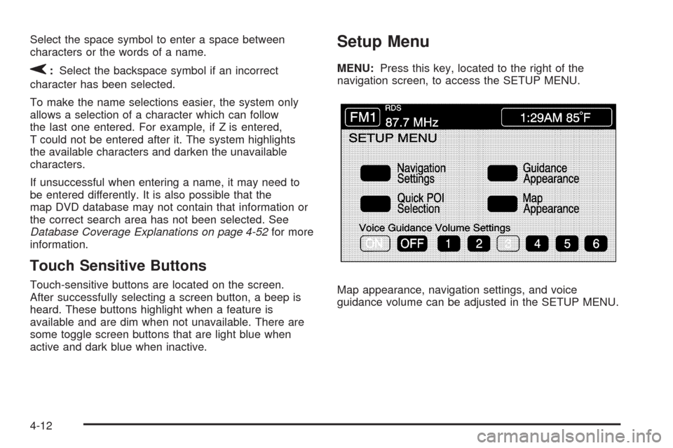
Setup Menu
MENU:Press this key, located to the right of the
navigation screen, to access the SETUP MENU.
Map appearance, navigation settings, and voice
guidance volume can be adjusted in the SETUP MENU.
4-12
Page 227 of 462
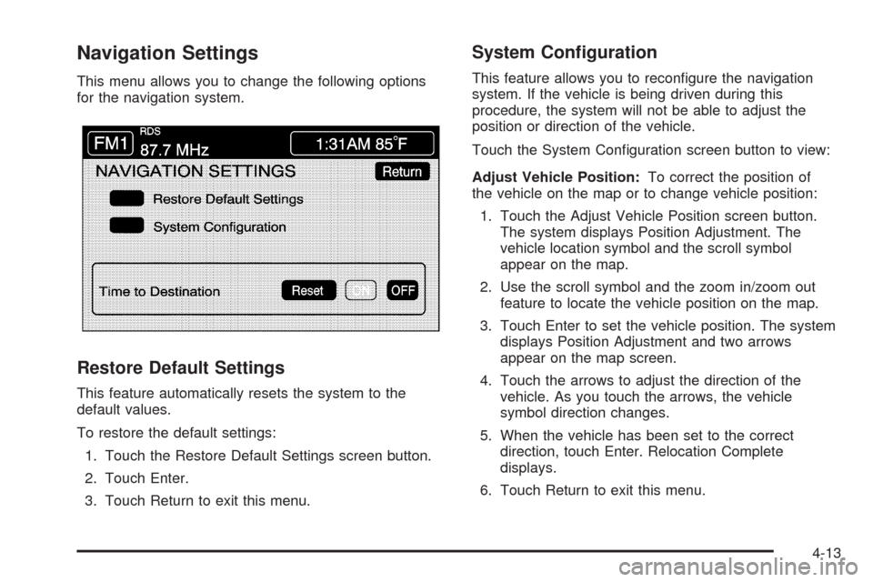
Navigation Settings
This menu allows you to change the following options
for the navigation system.
Restore Default Settings
This feature automatically resets the system to the
default values.
To restore the default settings:
1. Touch the Restore Default Settings screen button.
2. Touch Enter.
3. Touch Return to exit this menu.
System Con�guration
This feature allows you to recon�gure the navigation
system. If the vehicle is being driven during this
procedure, the system will not be able to adjust the
position or direction of the vehicle.
Touch the System Con�guration screen button to view:
Adjust Vehicle Position:To correct the position of
the vehicle on the map or to change vehicle position:
1. Touch the Adjust Vehicle Position screen button.
The system displays Position Adjustment. The
vehicle location symbol and the scroll symbol
appear on the map.
2. Use the scroll symbol and the zoom in/zoom out
feature to locate the vehicle position on the map.
3. Touch Enter to set the vehicle position. The system
displays Position Adjustment and two arrows
appear on the map screen.
4. Touch the arrows to adjust the direction of the
vehicle. As you touch the arrows, the vehicle
symbol direction changes.
5. When the vehicle has been set to the correct
direction, touch Enter. Relocation Complete
displays.
6. Touch Return to exit this menu.
4-13
Page 228 of 462
Calibrate Vehicle Speed Signal:If there are tire
pressure differences or if a spare tire is installed, the
navigation system automatically recalibrates the system.
To manually calibrate the system:
1. Touch Start to begin calibration.
2. Touch Return to exit this menu.
Time to Destination
This feature allows you to view the estimated time to
travel from your current position to the destination, and
to reset the average speed to factory default settings.
Estimated travel time is based on calculated route
information and the vehicle’s average speed. Touch ON
to turn this feature on, OFF to turn this feature off, or
Reset to restore vehicle speed default settings. With this
feature on, the estimated travel time to destination
displays along with the distance to destination.
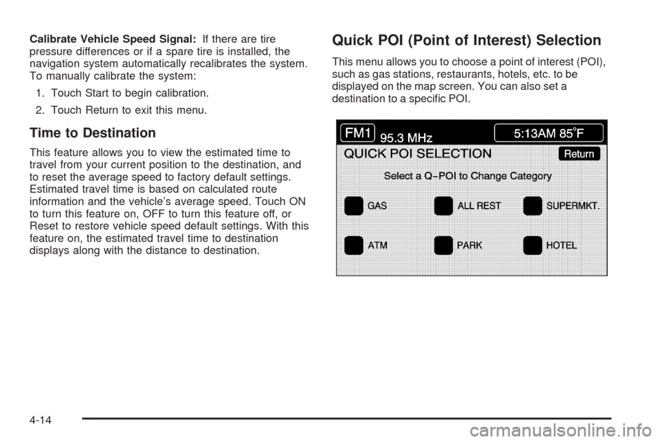
Quick POI (Point of Interest) Selection
This menu allows you to choose a point of interest (POI),
such as gas stations, restaurants, hotels, etc. to be
displayed on the map screen. You can also set a
destination to a speci�c POI.
4-14
Page 243 of 462
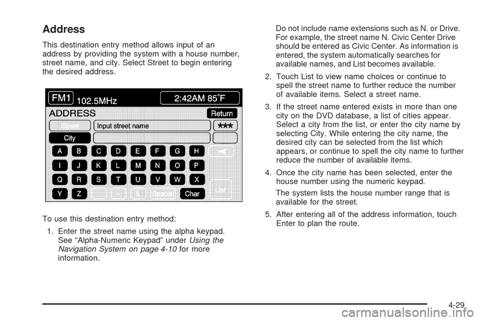
Address
This destination entry method allows input of an
address by providing the system with a house number,
street name, and city. Select Street to begin entering
the desired address.
To use this destination entry method:
1. Enter the street name using the alpha keypad.
See “Alpha-Numeric Keypad” underUsing the
Navigation System on page 4-10for more
information.Do not include name extensions such as N. or Drive.
For example, the street name N. Civic Center Drive
should be entered as Civic Center. As information is
entered, the system automatically searches for
available names, and List becomes available.
2. Touch List to view name choices or continue to
spell the street name to further reduce the number
of available items. Select a street name.
3. If the street name entered exists in more than one
city on the DVD database, a list of cities appear.
Select a city from the list, or enter the city name by
selecting City. While entering the city name, the
desired city can be selected from the list which
appears, or continue to spell the city name to further
reduce the number of available items.
4. Once the city name has been selected, enter the
house number using the numeric keypad.
The system lists the house number range that is
available for the street.
5. After entering all of the address information, touch
Enter to plan the route.
4-29
Page 251 of 462
Route Setting
This feature displays and changes the planning methods
used each time you plan a route. Planning method
options, allowing selection of the fastest route based on
time or distance, using only major roads, toll roads,
and using ferries based on the navigation system’s
information and information contained on the map DVD.
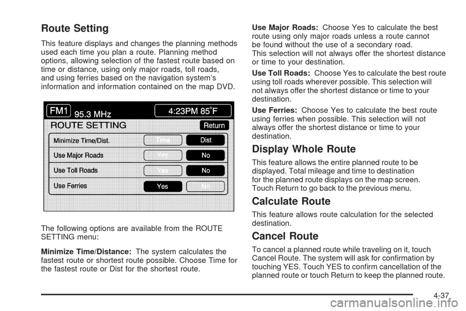
The following options are available from the ROUTE
SETTING menu:
Minimize Time/Distance:The system calculates the
fastest route or shortest route possible. Choose Time for
the fastest route or Dist for the shortest route.Use Major Roads:Choose Yes to calculate the best
route using only major roads unless a route cannot
be found without the use of a secondary road.
This selection will not always offer the shortest distance
or time to your destination.
Use Toll Roads:Choose Yes to calculate the best route
using toll roads wherever possible. This selection will
not always offer the shortest distance or time to your
destination.
Use Ferries:Choose Yes to calculate the best route
using ferries when possible. This selection will not
always offer the shortest distance or time to your
destination.
Display Whole Route
This feature allows the entire planned route to be
displayed. Total mileage and time to destination
for the planned route displays on the map screen.
Touch Return to go back to the previous menu.
Calculate Route
This feature allows route calculation for the selected
destination.
Cancel Route
To cancel a planned route while traveling on it, touch
Cancel Route. The system will ask for con�rmation by
touching YES. Touch YES to con�rm cancellation of the
planned route or touch Return to keep the planned route.
4-37
Page 253 of 462
Installing the DVD Map Disc
Your dealer/retailer may have installed the map DVD.
If the map DVD was not installed, do the following
to load it:
1. Turn the ignition on.
2. With the vehicle in P (Park), press and hold the
TILT key until a beep is heard. The system’s
faceplate opens.
3. If already loaded, the map DVD or a CD ejects from
the slot.
4. Load the map DVD into the slot by inserting it
partway. The system pulls it in.
5. Press and release the TILT key to close the
faceplate.Notice:Shifting out of P (Park) with the system’s
faceplate open will cause the faceplate to close
automatically. This could cause damage to a
CD, DVD or the system if it is partially loaded.
Before shifting out of P (Park), make sure that the
DVD or CD is loaded properly. The vehicle must
be shifted back into P (Park) to close the faceplate.
Once the map DVD is inserted correctly, you will
have the following two choices:
LANGUAGE
I AGREE
The language can be changed at this time. See
“Language” underNavigation Audio System on
page 4-52for more information on choosing a language.
Once a language has been selected, touch I AGREE
to plan a route. The map appears showing the current
vehicle position.
4-39