navigation CHEVROLET CITY EXPRESS 2018 Infotainment System Guide
[x] Cancel search | Manufacturer: CHEVROLET, Model Year: 2018, Model line: CITY EXPRESS, Model: CHEVROLET CITY EXPRESS 2018Pages: 74, PDF Size: 0.86 MB
Page 2 of 74

Chevrolet City Express Infotainment System (GMNA-Localizing-U.S./Canada-
11683801) - 2018 - crc - 7/12/17
ContentsIntroduction . . . . . . . . . . . . . . . . . . . . . 2
Radio . . . . . . . . . . . . . . . . . . . . . . . . . . . 8
Audio Players . . . . . . . . . . . . . . . . . 14
Navigation . . . . . . . . . . . . . . . . . . . . . 23
Voice Recognition . . . . . . . . . . . . . 52
Settings . . . . . . . . . . . . . . . . . . . . . . . 56
Bluetooth Phone/Devices . . . . . . 60
Trademarks and LicenseAgreements . . . . . . . . . . . . . . . . . . 66
Index . . . . . . . . . . . . . . . . . . . . 70
Page 4 of 74
Chevrolet City Express Infotainment System (GMNA-Localizing-U.S./Canada-
11683801) - 2018 - crc - 7/12/17
Introduction 3
All functions are available when the
vehicle is parked. Before driving:
.Become familiar with the
controls on the center stack,
controls on the steering wheel,
and the infotainment display.
. Set up the audio by presetting
favorite stations, setting the
tone, and adjusting the
speakers.
. Set up phone numbers in
advance so they can be called
easily by touching a single icon
or by using a single voice
command for vehicles equipped
with phone capability.
The navigation system should not
be left running with the engine
stopped. Doing so may discharge
the vehicle battery.
Infotainment System Overview
The infotainment system is operated
by using the controls, infotainment
display, steering wheel controls, and
voice recognition.
See Using the System 06.
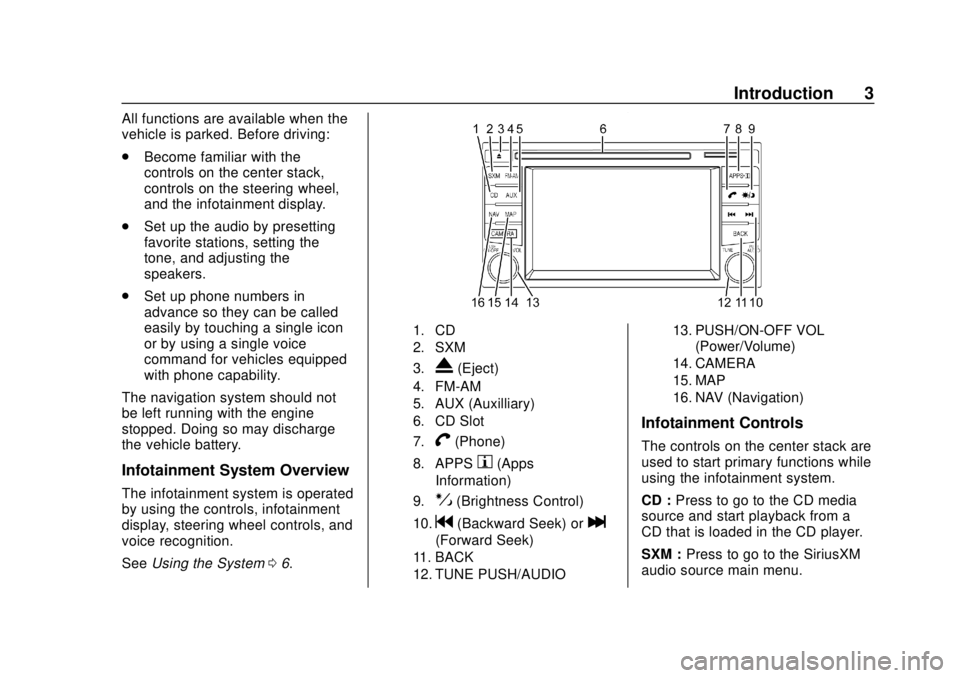
1. CD
2. SXM
3.
X(Eject)
4. FM-AM
5. AUX (Auxilliary)
6. CD Slot
7.
V(Phone)
8. APPSh(Apps
Information)
9.!(Brightness Control)
10.g(Backward Seek) orl
(Forward Seek)
11. BACK
12. TUNE PUSH/AUDIO 13. PUSH/ON-OFF VOL
(Power/Volume)
14. CAMERA
15. MAP
16. NAV (Navigation)
Infotainment Controls
The controls on the center stack are
used to start primary functions while
using the infotainment system.
CD : Press to go to the CD media
source and start playback from a
CD that is loaded in the CD player.
SXM : Press to go to the SiriusXM
audio source main menu.
Page 5 of 74
Chevrolet City Express Infotainment System (GMNA-Localizing-U.S./Canada-
11683801) - 2018 - crc - 7/12/17
4 Introduction
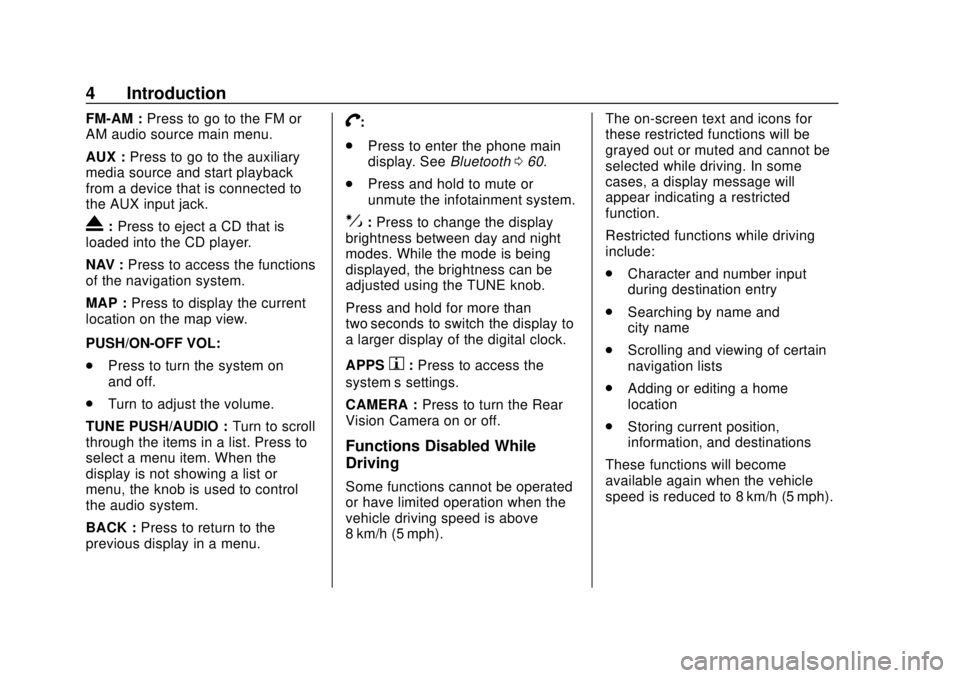
FM-AM :Press to go to the FM or
AM audio source main menu.
AUX : Press to go to the auxiliary
media source and start playback
from a device that is connected to
the AUX input jack.
X: Press to eject a CD that is
loaded into the CD player.
NAV : Press to access the functions
of the navigation system.
MAP : Press to display the current
location on the map view.
PUSH/ON-OFF VOL:
. Press to turn the system on
and off.
. Turn to adjust the volume.
TUNE PUSH/AUDIO : Turn to scroll
through the items in a list. Press to
select a menu item. When the
display is not showing a list or
menu, the knob is used to control
the audio system.
BACK : Press to return to the
previous display in a menu.
V:
. Press to enter the phone main
display. See Bluetooth060.
. Press and hold to mute or
unmute the infotainment system.
!:Press to change the display
brightness between day and night
modes. While the mode is being
displayed, the brightness can be
adjusted using the TUNE knob.
Press and hold for more than
two seconds to switch the display to
a larger display of the digital clock.
APPS
h: Press to access the
system’ s settings.
CAMERA : Press to turn the Rear
Vision Camera on or off.
Functions Disabled While
Driving
Some functions cannot be operated
or have limited operation when the
vehicle driving speed is above
8 km/h (5 mph). The on-screen text and icons for
these restricted functions will be
grayed out or muted and cannot be
selected while driving. In some
cases, a display message will
appear indicating a restricted
function.
Restricted functions while driving
include:
.
Character and number input
during destination entry
. Searching by name and
city name
. Scrolling and viewing of certain
navigation lists
. Adding or editing a home
location
. Storing current position,
information, and destinations
These functions will become
available again when the vehicle
speed is reduced to 8 km/h (5 mph).
Page 24 of 74
Chevrolet City Express Infotainment System (GMNA-Localizing-U.S./Canada-
11683801) - 2018 - crc - 7/12/17
Navigation 23
Navigation
Using the Navigation
System
This system is primarily designed to
help reach a destination, and it also
performs other functions as outlined
in this manual. The driver must use
the system safely and properly.
Information concerning road
conditions, traffic signs, and the
availability of services may not
always be up-to-date. The system is
not a substitute for safe, proper, and
legal driving.
Before using the navigation system,
read the following safety
information. Always use the system
as outlined in this manual.
{Warning
.To operate the navigation
system, first park the vehicle
in a safe location and set
the parking brake.
(Continued)
Warning (Continued)
Operating the system while
driving can distract the
driver and may result in a
serious accident.
. Do not rely on route
guidance alone. Always be
sure that all driving
maneuvers are legal and
safe in order to avoid
accidents.
. Do not disassemble or
modify this system. Doing
this may result in accidents,
fire, or electrical shock.
. If there are any foreign
objects in the system
hardware, spilled liquid on
the system, or smoke or a
smell coming from it, stop
using the system
immediately and contact
your dealer. Ignoring such
conditions may lead to
accidents, fire, or electrical
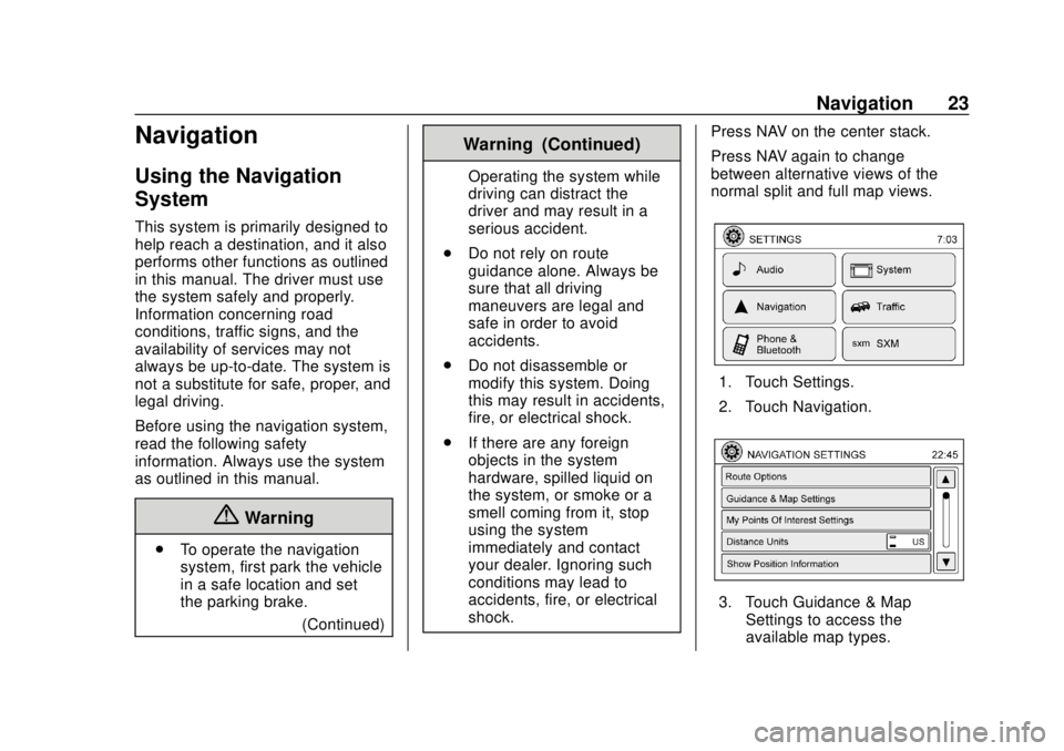
shock. Press NAV on the center stack.
Press NAV again to change
between alternative views of the
normal split and full map views.
1. Touch Settings.
2. Touch Navigation.
3. Touch Guidance & Map
Settings to access the
available map types.
Page 25 of 74
Chevrolet City Express Infotainment System (GMNA-Localizing-U.S./Canada-
11683801) - 2018 - crc - 7/12/17
24 Navigation
Map Types
.2-Dimensional (2D) View –The
2D map is a two-dimensional flat
representation of the map data,
similar to a road map.
. 2-Dimensional (2DN) View –The
2DN map is a two-dimensional
representation of the map data,
similar to a road map, focused
on the vehicle’s position with the
top of the map aligned North.
. 3-Dimensional (3D) View –The
3D map displays the map from
an elevated perspective,
providing a panoramic view over
a long distance.
The map in 3D view always
appears with the current forward
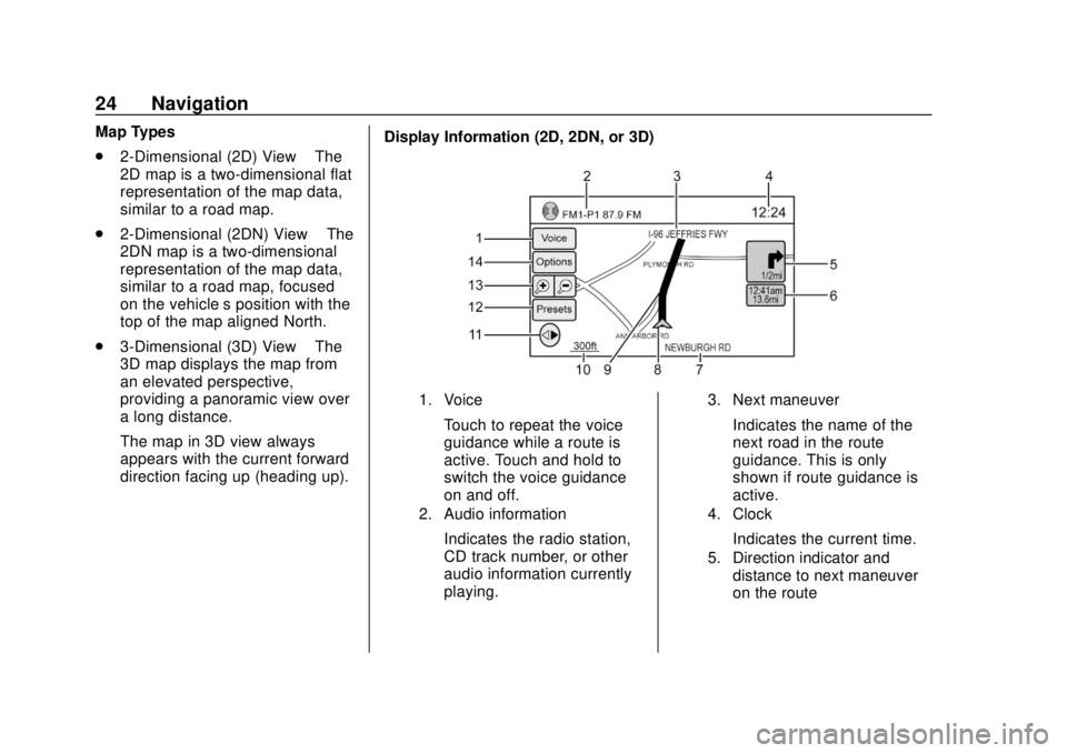
direction facing up (heading up). Display Information (2D, 2DN, or 3D)
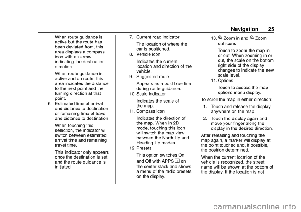
1. Voice
Touch to repeat the voice
guidance while a route is
active. Touch and hold to
switch the voice guidance
on and off.
2. Audio information
Indicates the radio station,
CD track number, or other
audio information currently
playing.
3. Next maneuver
Indicates the name of the
next road in the route
guidance. This is only
shown if route guidance is
active.
4. Clock
Indicates the current time.
5. Direction indicator and
distance to next maneuver
on the route
Page 26 of 74
Chevrolet City Express Infotainment System (GMNA-Localizing-U.S./Canada-
11683801) - 2018 - crc - 7/12/17
Navigation 25
When route guidance is
active but the route has
been deviated from, this
area displays a compass
icon with an arrow
indicating the destination
direction.
When route guidance is
active and on route, this
area indicates the distance
to the next point and the
turning direction at that
point.
6. Estimated time of arrivaland distance to destination
or remaining time of travel
and distance to destination
When touching this
selection, the indicator will
switch between estimated
arrival time and remaining
travel time.
This indicator only appears
once the destination is set
and the route guidance is
initiated.
7. Current road indicator
The location of where the
car is positioned.
8. Vehicle icon
Indicates the current
location and direction of the
vehicle.
9. Suggested route
Appears as a bold blue line
during route guidance.
10. Scale indicator
Indicates the scale of
the map.
11. Compass icon
Indicates the direction of
the map. When in 2D
mode, touching this icon
will switch the map view
between the North Up and
Heading Up modes.
12. Presets
This option switches On
and Off with APPS
hon
the center stack and shows
a menu of the radio presets
on the display.
13.VZoom in andUZoom
out icons
Touch to zoom the map in
or out. When zooming in or
out, the scale on the bottom
right side of the display
changes to indicate the new
scale level.
14. Options
Touch to access the map
options menu display.
To scroll the map in either direction: 1. Touch and release the display anywhere on the map.
2. Touch the display again and move your finger along the
display in the desired direction.
After releasing and touching the
map again, a marker will display at
the point touched and, if possible,
the position determined.
When the current location of the
vehicle is recognized, the street
name will be shown at the bottom of
the display. If the location is not
Page 27 of 74
Chevrolet City Express Infotainment System (GMNA-Localizing-U.S./Canada-
11683801) - 2018 - crc - 7/12/17
26 Navigation
recognized by the system,
coordinates corresponding to the
marker’s position will be displayed.
Returning to the Current Vehicle
Location
The basic map view displays the
current location of the vehicle. The
current location can be displayed
again even after the map is moved,
or after the Menu is displayed.
Press MAP or BACK on the center
stack and the current location
displays on the map.
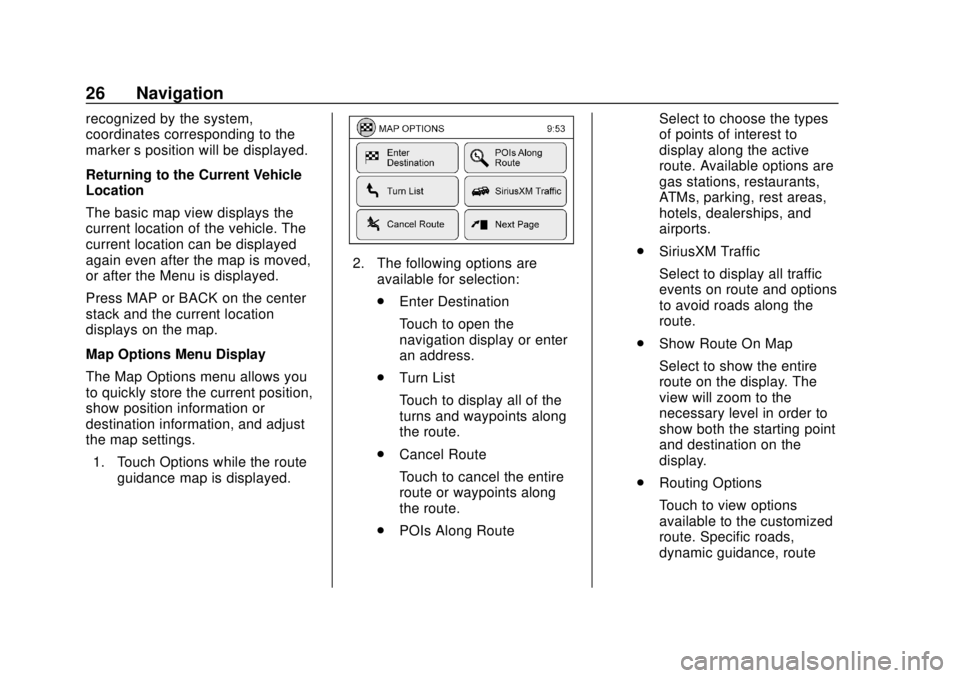
Map Options Menu Display
The Map Options menu allows you
to quickly store the current position,
show position information or
destination information, and adjust
the map settings. 1. Touch Options while the route guidance map is displayed.
2. The following options areavailable for selection:
.Enter Destination
Touch to open the
navigation display or enter
an address.
. Turn List
Touch to display all of the
turns and waypoints along
the route.
. Cancel Route
Touch to cancel the entire
route or waypoints along
the route.
. POIs Along Route Select to choose the types
of points of interest to
display along the active
route. Available options are
gas stations, restaurants,
ATMs, parking, rest areas,
hotels, dealerships, and
airports.
. SiriusXM Traffic
Select to display all traffic
events on route and options
to avoid roads along the
route.
. Show Route On Map
Select to show the entire
route on the display. The
view will zoom to the
necessary level in order to
show both the starting point
and destination on the
display.
. Routing Options
Touch to view options
available to the customized
route. Specific roads,
dynamic guidance, route
Page 28 of 74
Chevrolet City Express Infotainment System (GMNA-Localizing-U.S./Canada-
11683801) - 2018 - crc - 7/12/17
Navigation 27
type, use of freeways, types
of roads, and use of ferries
can all be adjusted.
. Show Position Information
Touch to display the
latitude, longitude, and
altitude for the current
position of the vehicle.
Location can also the
stored to the Address Book.
. Show Waypoints
Touch to add or show a list
of waypoints along the
route.
. Guidance & Map Settings
Touch to switch guidance
information and map
settings options.
Changing the Map Scale
When using + or −for zooming in or
out, the scale on the bottom left side
of the display changes to indicate
the new scale level. Looking at Information on the Map
Icons of various categories of
locations can be displayed on
the map.
Some places of interest on divided
highways may show the equivalent
place of interest on the opposite
side of the road as being closer than
the place in the traveling direction.
Confirm location of the place before
following the route.
Map Settings for the Map Display
Other settings are available for the
map display, such as switching the
map view or changing the map
direction.
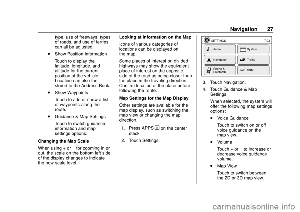
1. Press APPS
hon the center
stack.
2. Touch Settings.
3. Touch Navigation.
4. Touch Guidance & Map Settings.
When selected, the system will
offer the following map settings
options:
.Voice Guidance
Touch to switch on or off
voice guidance on the
map view.
. Volume
Touch + or −to increase or
decrease voice guidance
volume.
. Map View
Touch to switch between
the 2D or 3D map view.
Page 29 of 74

Chevrolet City Express Infotainment System (GMNA-Localizing-U.S./Canada-
11683801) - 2018 - crc - 7/12/17
28 Navigation
.2D-North/Heading Up
Touch to switch the display
between Head and North
for 2D mode. When Head is
selected, the display always
shows the map in the
driving direction. When
North is selected, the top of
the map is always oriented
north. This option can only
be selected when the Map
View is set to 2D.
. Auto Zoom
Touch to choose a setting
for automatic zooming.
Available settings are
Never, Always, and Only
with a Route.
. Show Points of Interest
on Map
Touch to switch various
map icons on or off
including gas stations,
restaurants, banks, and
parking. .
My Points of Interest Alert
Touch to control options.
Choose Off to disable the
alert. Choose Show Only to
have the alert display.
Choose Show & Beep to
have an audible beep in
addition to the alert
displaying.
. Show Presets On Map
Touch to switch on or off
the radio station preset on
the map view.
. Map Data Information
Touch to display the version
of the currently
installed map.
. Split Map for Freeway Exit
Touch to switch on or off
the split view map when
approaching a freeway exit.
. Show Lane Information
Touch to switch on or off
lane information when
available. .
Show Speed Limit
Touch to switch on or off
the display of speed limit
information when available.
. Show Estimated Time
Touch to control the display
of estimated time of arrival
or trip time remaining.
. Customize Travel Speed
Touch to customize travel
speeds on local roads and
freeways the along route.
. Speed Limit Warning
Touch to control the limit
alert that activates when
the vehicle speed is greater
then the speed limit
information for the current
location. Choose Off to
disable the alert. Choose
Show Only to have the alert
display. Choose Show &
Beep to have an audible
beep in addition to the alert
displaying.
Page 30 of 74
Chevrolet City Express Infotainment System (GMNA-Localizing-U.S./Canada-
11683801) - 2018 - crc - 7/12/17
Navigation 29
.Speed Limit Sensitivity
Touch to change the
sensitivity level for the
speed limit warning.
Choose a value between
zero and 30.
. Speed Warning for Curves
Touch to control the alert
that activates depending on
vehicle speed and a curve
in the road ahead. Choose
Off to disable the alert.
Choose Show Only to have
the alert display. Choose
Show & Beep to have an
audible beep in addition to
the alert displaying.
. Distance Units
Touch to switch between
US or Metric for the
distance units on the
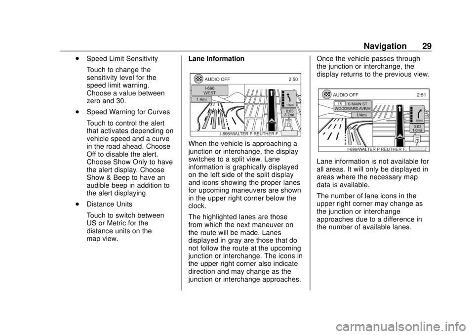
map view. Lane Information
When the vehicle is approaching a
junction or interchange, the display
switches to a split view. Lane
information is graphically displayed
on the left side of the split display
and icons showing the proper lanes
for upcoming maneuvers are shown
in the upper right corner below the
clock.
The highlighted lanes are those
from which the next maneuver on
the route will be made. Lanes
displayed in gray are those that do
not follow the route at the upcoming
junction or interchange. The icons in
the upper right corner also indicate
direction and may change as the
junction or interchange approaches. Once the vehicle passes through
the junction or interchange, the
display returns to the previous view.
Lane information is not available for
all areas. It will only be displayed in
areas where the necessary map
data is available.
The number of lane icons in the
upper right corner may change as
the junction or interchange
approaches due to a difference in
the number of available lanes.