warning FIAT DOBLO 2007 1.G Connect NavPlus Manual
[x] Cancel search | Manufacturer: FIAT, Model Year: 2007, Model line: DOBLO, Model: FIAT DOBLO 2007 1.GPages: 234, PDF Size: 3.56 MB
Page 190 of 234
CONNECT Nav+
189Nero603 83 540 Connect DOBLO Livello 4 GB
189
GENERAL
INFORMATION
The navigator integrated in the
CONNECT Nav+ allows you to reach
the chosen destination by visual and
voice instructions. Use of the naviga-
tion system is quick, convenient, safe
and above all very flexible because it
allows you to call up already pro-
grammed destinations or points of ref-
erence such as hotels, monuments,
public structures, fuel stations or
Fiat Dealerships.
The vehicle position is determined
through the GPS system (Global Posi-
tioning System) installed on the vehicle.
The GPS system is fitted with an an-
tenna and a reception module inte-
grated in the telematic system. This sys-
tem configuration dynamically process-
es the satellite signals, those from the
right and left odometer, the reversing
signal and the information of the gyro-
scope integrated in the navigation com-
puter, integrating them with the cur-
rent position of the vehicle to obtain an
“estimated vehicle point”.The signals from the right and left
odometer make it possible to deter-
mine the movement of the vehicle, the
gyroscope signal identifies any turn-
ing and the reversing sensor distin-
guishes the direction of travel.
The Fiat navigation system helps the
driver while he/ahe drives by suggest-
ing vocally and graphically the opti-
mum routing to reach the preset des-
tination.IMPORTANT NOTES
– GPS reception is difficult under
trees, among tall buildings, in multi-lev-
el car parks, tunnels and everywhere
reception of the satellite antenna may
be hindered.
– The GPS system needs about 15
minutes for activation if the vehicle
battery is disconnected.
– The GPS system needs a few min-
utes to determine the new position of
the vehicle if it is turned off and the ve-
hicle is moved with the system off (e.g.:
by breakdown van).
– In the lack of satellite information,
the system uses information from the
gyroscope and from the special sen-
sors for temporary data analysis.
– The GPS satellite aerial must not
be covered with metal or damp ob-
jects.
N N
A A
V V
I I
G G
A A
T T
O O
R R
( (
N N
A A
V V
) )
The navigation system sug-
gestions do not exempt the
driver from full responsibility due to
his driving behaviour and to com-
pliance with road and other traffic
regulations. The responsibility for
road safety always and in any case
lies with the vehicle driver.
WARNING
189-209 Doblo Connect GB 15-06-2007 10:38 Pagina 189
Page 192 of 234
CONNECT Nav+
191Nero603 83 540 Connect DOBLO Livello 4 GB
191
SCREEN OPTIONS
AND FUNCTIONS
The main information and functions
provided and managed by the naviga-
tion system are:
ëGPS signal symbol which differs in
colour depending on the quality of re-
ception;
– voice and visual instructions with
indications of distance from the des-
tination and planned arrival time;
– detailed map in different colours
and with different scales to clearly
show the vehicle position, route and
destination;
– customisation of the navigation sys-
tem with possibility of entering pre-
memorised destinations with street
and street number;
– automatic memorising of the last 8
destinations;
– name of current street;– possibility to choose the route ac-
cording to personal preference;
– information on current position;
– information on arrival time;
– system diagnostics and warnings
about possible disturbances.
If the system contains a wrong CD-
ROM, an audio CD or no CD, when-
ever the system asks for the navigation
CD-ROM for route calculation or map
up-date, the insertion prompt will ap-
pear on the display.
Navigation functions are mainly con-
trolled using the knob 22-fig. 1:
– rotate the knob to access the var-
ious map zoom levels;
– press the knob to display the first
menu page;
– use the knob to select and confirm
the “Other menu” item and access the
following menu pages;
– press the knob again and the menu
page will disappear.
GRAPHIC
INSTRUCTIONS
The main navigation function page
and the MAIN page display the ma-
noeuvres to be made using arrows or
symbols.
The downward arrow represents
next manoeuvre (turn left, right,
straight on, U-turn) while the upward
arrow or the symbol on top represent
the next one. The number displayed
under the arrow indicates the vehicle
distance from the turn point.
The small arrow down on the right-
hand side of the display (on the MAIN
page) or in the top box (on the main
navigation function page) indicates the
destination direction. Next to this ar-
row the planned arrival time and the
distance still to be covered are also in-
dicated.
189-209 Doblo Connect GB 15-06-2007 10:38 Pagina 191
Page 203 of 234
202Nero603 83 540 Connect DOBLO Livello 4 GB
CONNECT Nav+
202
The navigation system is able to han-
dle RDS TMC messages also supplying
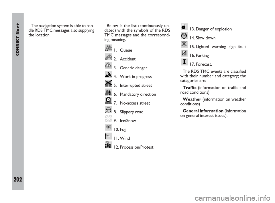
the location.Below is the list (continuously up-
dated) with the symbols of the RDS
TMC messages and the correspond-
ing meaning.
1. Queue
2. Accident
3. Generic danger
4. Work in progress
5. Interrupted street
6. Mandatory direction
7. No-access street
8. Slippery road
9. Ice/Snow
10. Fog
11. Wind
12. Procession/Protest13. Danger of explosion
14. Slow down
15. Lighted warning sign fault
16. Parking
17. Forecast.
The RDS TMC events are classified
with their number and category; the
categories are:
Traffic(information on traffic and
road conditions)
Weather(information on weather
conditions)
General information(information
on general interest issues).
189-209 Doblo Connect GB 15-06-2007 10:38 Pagina 202
Page 207 of 234
206Nero603 83 540 Connect DOBLO Livello 4 GB
CONNECT Nav+
206
“Highway info”
This option, that can be activated on-
ly on highways, provides information
about the next two exits (name and
distance from current position) and
about service areas (distance from
current position).ALTERNATIVE ROUTE
Selecting “Alternative route” on the
second page of the navigation menu,
the user asks the system, if possible,
to locate a new route compared with
the one calculated previously to reach
the destination.
Calculation of the new route starts
from the vehicle current position and
ends at the distance set by the user.
After calculating the new route, the
display shows the route differences
and the time estimated for reaching
the destination asking to confirm
(YES/NO) if the user intends to adopt
the new route.
Confirming, the navigation system
will replace the current route with the
alternate one, while cancelling the
original route will be followed.
If no alternate routes may be identi-
fied, a warning message is displayed.DELETE DESTINATIONS
This function, available on the navi-
gation menu second page, is used to
delete the selected destination from
the memory.
ENABLE ROUTE
CALCULATION
The “Enable route calculation” op-
tion, accessible from the third page of
the navigation menu is for enabling
road guide or not (YES/NO). Keep-
ing trace of the vehicle position and
the recommended route, it is possible
to activate/cease the pronouncement
and display of the sequence of ma-
noeuvres to be accomplished and cal-
culation of the distances in relation to
the next manoeuvres.
189-209 Doblo Connect GB 15-06-2007 10:38 Pagina 206
Page 225 of 234
224Nero603 83 540 Connect DOBLO Livello 4 GB
CONNECT Nav+
224
“Infomobility” FUNCTION
“Connect”
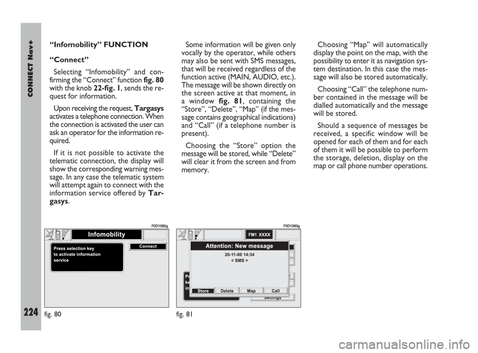
Selecting “Infomobility” and con-
firming the “Connect” function fig. 80
with the knob 22-fig. 1, sends the re-
quest for information.
Upon receiving the request, Targasys
activates a telephone connection. When
the connection is activated the user can
ask an operator for the information re-
quired.
If it is not possible to activate the
telematic connection, the display will
show the corresponding warning mes-
sage. In any case the telematic system
will attempt again to connect with the
information service offered by Tar-
gasys.Some information will be given only
vocally by the operator, while others
may also be sent with SMS messages,
that will be received regardless of the
function active (MAIN, AUDIO, etc.).
The message will be shown directly on
the screen active at that moment, in
a window fig. 81, containing the
“Store”, “Delete”, “Map” (if the mes-
sage contains geographical indications)
and “Call” (if a telephone number is
present).
Choosing the “Store” option the
message will be stored, while “Delete”
will clear it from the screen and from
memory.Choosing “Map” will automatically
display the point on the map, with the
possibility to enter it as navigation sys-
tem destination. In this case the mes-
sage will also be stored automatically.
Choosing “Call” the telephone num-
ber contained in the message will be
dialled automatically and the message
will be stored.
Should a sequence of messages be
received, a specific window will be
opened for each of them and for each
of them it will be possible to perform
the storage, deletion, display on the
map or call phone number operations.
fig. 80
F0D1062g
fig. 81
F0D1063g
223-229 Doblo Connect GB 15-06-2007 10:39 Pagina 224
Page 230 of 234
CONNECT Nav+
229Nero603 83 540 Connect DOBLO Livello 4 GB
229
CALLS FOR MEDICAL
ADVICE OR ROADSIDE
ASSISTANCE
During the forwarding of a call for as-
sistance to the operating centre, any
other operations activated are inter-
rupted and the volume of any audio
sources (except the phone) is muted.
These conditions will be maintained as
long as the call for assistance is active,
with the corresponding screen on the
display.
If a phone call is received while for-
warding a request for assistance, the
corresponding alert will not be shown
on the display but the ringer will ring.
If the user decides to accept the call
and briefly presses the
òkey 13-
fig. 1, the assistance call screen goes
off the display.IMPORTANTThe call for assis-
tance is always forwarded; however, if
the you accept the incoming call, the
Targasysoperator might have diffi-
culty in contacting you since the num-
ber could be busy.
When the call has been sent, the dis-
play shows the corresponding call for-
warded message for about 4 seconds.If for any reason the call for assis-
tance cannot be sent, the display
shows a warning message and the user
is then asked if he wants to activate a
phone call in any case (*) to the op-
erating centre to avail of the service
required, even if in this case the op-
erating centre will no longer be able
to locate the vehicle.
(*) The call is normally made using
the toll-free number, while it is at the
user’s expense if it is made in roam-
ing conditions.
223-229 Doblo Connect GB 15-06-2007 10:39 Pagina 229