sat nav FIAT STILO 2004 1.G Connect NavPlus Manual
[x] Cancel search | Manufacturer: FIAT, Model Year: 2004, Model line: STILO, Model: FIAT STILO 2004 1.GPages: 166, PDF Size: 3.8 MB
Page 65 of 166
CONNECT Nav+
64
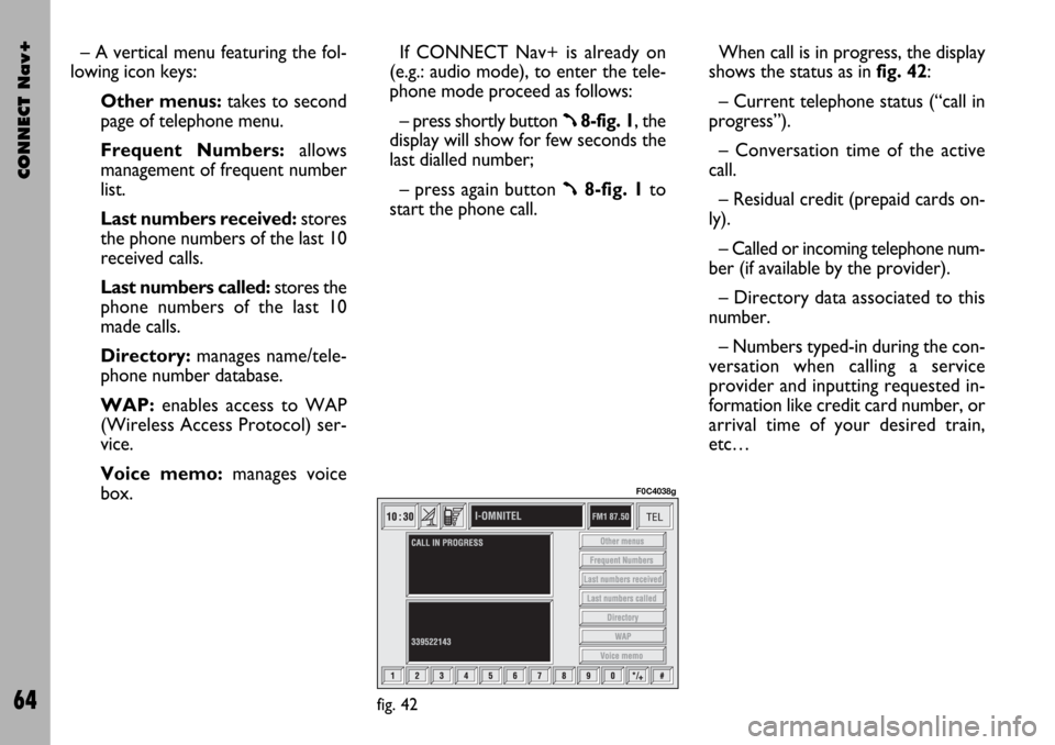
– A vertical menu featuring the fol-
lowing icon keys:
Other menus:takes to second
page of telephone menu.
Frequent Numbers: allows
management of frequent number
list.
Last numbers received:stores
the phone numbers of the last 10
received calls.
Last numbers called: stores the
phone numbers of the last 10
made calls.
Directory:manages name/tele-
phone number database.
WAP:enables access to WAP
(Wireless Access Protocol) ser-
vice.
Voice memo:manages voice
box.If CONNECT Nav+ is already on
(e.g.: audio mode), to enter the tele-
phone mode proceed as follows:
– press shortly button
ß8-fig. 1, the
display will show for few seconds the
last dialled number;
– press again button
ß8-fig. 1to
start the phone call.When call is in progress, the display
shows the status as in fig. 42:
– Current telephone status (“call in
progress”).
– Conversation time of the active
call.
– Residual credit (prepaid cards on-
ly).
– Called or incoming telephone num-
ber (if available by the provider).
– Directory data associated to this
number.
– Numbers typed-in during the con-
versation when calling a service
provider and inputting requested in-
formation like credit card number, or
arrival time of your desired train,
etc…
fig. 42
F0C4038g
Page 68 of 166
CONNECT Nav+
67
INCOMING CALLS
Whichever is the CONNECT Nav+
system active mode, when an external
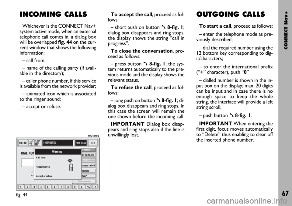
telephone call comes in, a dialog box
will be overlapped fig. 44on the cur-
rent window that shows the following
information:
– call from:
– name of the calling party (if avail-
able in the directory);
– caller phone number, if this service
is available from the network provider;
– animated icon which is associated
to the ringer sound;
– accept or refuse.To accept the call, proceed as fol-
lows:
– short push on button ß8-fig. 1;
dialog box disappears and ring stops,
the display shows the string “call in
progress”.
To close the conversation, pro-
ceed as follows:
– press button
ß8-fig. 1; the sys-
tem returns automatically to the pre-
vious mode and the display shows the
relevant status.
To refuse the call, proceed as fol-
lows:
– long push on button
ß8-fig. 1; di-
alog box disappears and ring stops. In
this case the screen will remain the
one shown before the incoming call.
IMPORTANT Dialog box disap-
pears and ring stops also if the line is
unwillingly lost.
OUTGOING CALLS
To start a call, proceed as follows:
– enter the telephone mode as pre-
viously described;
– dial the required number using the
12 bottom key corresponding to dig-
it/characters;
– to enter the international prefix
(“+” character), push “0”
– dialled number is shown in the in-
put box on the display; max. 20 digits
can be input and in case there is no
enough space to keep the whole
string, the interface will provide a left
string scroll;
– push button
ß8-fig. 1.
IMPORTANTWhen entering the
first digit, focus moves automatically
to “Delete” thus enabling to clear off
the inserted phone number.
fig. 44
F0C4040g
Page 95 of 166
CONNECT Nav+
94
GENERAL
INFORMATION
The navigator integrated in the
CONNECT Nav+ allows you to
reach the chosen destination by visu-
al and voice instructions. Use of the
navigation system is quick, convenient,
safe and above all very flexible because
it allows you to call up already pro-
grammed destinations or points of ref-
erence such as hotels, monuments,
public structures, fuel stations orFi-
at Dealerships.
The car position is determined
through the GPS system (Global Posi-
tioning System) installed on the car.
The GPS system is fitted with an an-
tenna and a reception module inte-
grated in the telematic system. This
system configuration dynamically
processes the satellite signals, those
from the right and left odometer, the
reversing signal and the information of
the gyroscope integrated in the navi-
gation computer, integrating them
with the current position of the car to
obtain an “estimated car point”.The navigation system helps the dri-
ver while he/she drives by suggesting
vocally and graphically the optimum
routing to reach the preset destina-
tion.
The navigation system suggestions do
not exempt the driver from full re-
sponsibility due to his/her driving be-
haviour and to compliance with road
and other traffic regulations. The re-
sponsibility for road safety always and
in any case lies with the car driver.IMPORTANT NOTES
– GPS reception is difficult under
trees, among tall buildings, in multi-lev-
el car parks, tunnels and everywhere
reception of the satellite antenna may
be hindered.
– The GPS system needs about 15
minutes for activation if the car bat-
tery is disconnected.
– The GPS system needs a few min-
utes to determine the new position of
the car if it is turned off and the car
is moved with the system off (e.g.: on
ferryboat).
– The GPS satellite aerial must not
be covered with metal or damp ob-
jects.
The instantaneous car position is
identified in the CD-ROM and shown
on the display together with the topo-
graphic characteristics of the area
memorised on the CD-ROM. Access
to data on the CD-ROM requires a
few moments waiting for the map dis-
plays.
N N
A A
V V
I I
G G
A A
T T
O O
R R
( (
N N
A A
V V
) )
Page 96 of 166

CONNECT Nav+
95
IMPORTANT NOTES
– Accurate self-adjustment of the
navigation system requires approx.
100 km of travel the first time and
when tyres are changed; during this
stage the calculated position could be
less accurate.
– Continuous lack of grip at the
wheels (for example skidding on ice),
makes the system temporarily detect
an incorrect position.
The navigation system is completely
managed by the telematic system,
therefore the only operations that
may be required are replacement of
the CD-ROM to set the map of an-
other area or an updated map.
Access to the navigation main func-
tions is gained by short push on “NAV”
key 11-fig. 1 , whereas, a long push on
the same key will deactivate the navi-
gation function: the display shows NAV
OFF.
To switch the function on press the
“NAV” key 11-fig. 1again.
Each time you start the engine and
select the navigation function, the dis-
play will show the cautions for using
the system; the text displayed is as fol-
lows:“The FIAT navigation system guides
you in traffic and helps you reach your
destination. Comply with all local traf-
fic regulations, which take precedence
over the manoeuvres indicated by the
navigation system. Full responsibility
for operating the vehicle and observ-
ing all traffic regulations lies with the
driver”.
This page will not be displayed as
long as the ignition key is to MAR.SCREEN OPTIONS
AND FUNCTIONS
The main information and functions
provided and managed by the naviga-
tion system are:
– GPS signal symbol which differs in
colour depending on the quality of re-
ception ;
– voice and visual instructions with
indications of distance from the des-
tination and planned arrival time;
– detailed map in different colours
and with different scales to clearly
show the car position, route and des-
tination;
– customisation of the navigation sys-
tem with possibility of entering pre-
memorised destinations;
– automatic memorising of the last 8
destinations;
– name of current street;
– possibility to choose the route ac-
cording to personal preference;
– information on current position;
– information on arrival time.
Page 100 of 166
CONNECT Nav+
99
MAIN SCREEN
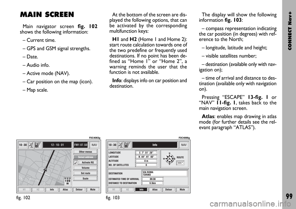
Main navigator screen fig. 102
shows the following information:
– Current time.
– GPS and GSM signal strengths.
– Date.
– Audio info.
– Active mode (NAV).
– Car position on the map (icon).
– Map scale.At the bottom of the screen are dis-
played the following options, that can
be activated by the corresponding
multifunction keys:
H1and H2(Home 1 and Home 2):
start route calculation towards one of
the two predefine or frequently used
destinations. If no point has been de-
fined as “Home 1” or “Home 2”, a
warning reminds the user that the
function is not available.
Info: displays info on car position and
destination.The display will show the following
information fig. 103:
– compass representation indicating
the car position (in degrees) with ref-
erence to the North;
– longitude, latitude and height;
– visible satellites number;
– destination (available only with nav-
igation on);
– time of arrival and distance to des-
tination (available only with navigation
on).
Pressing “ESCAPE” 13-fig. 1or
“NAV” 11-fig. 1, takes back to the
main navigation screen.
Atlas: enables map drawing in atlas
mode (for further details see the rel-
evant paragraph “ATLAS”).
fig. 102
F0C4063g
fig. 103
F0C4066g
Page 134 of 166
CONNECT Nav+
133
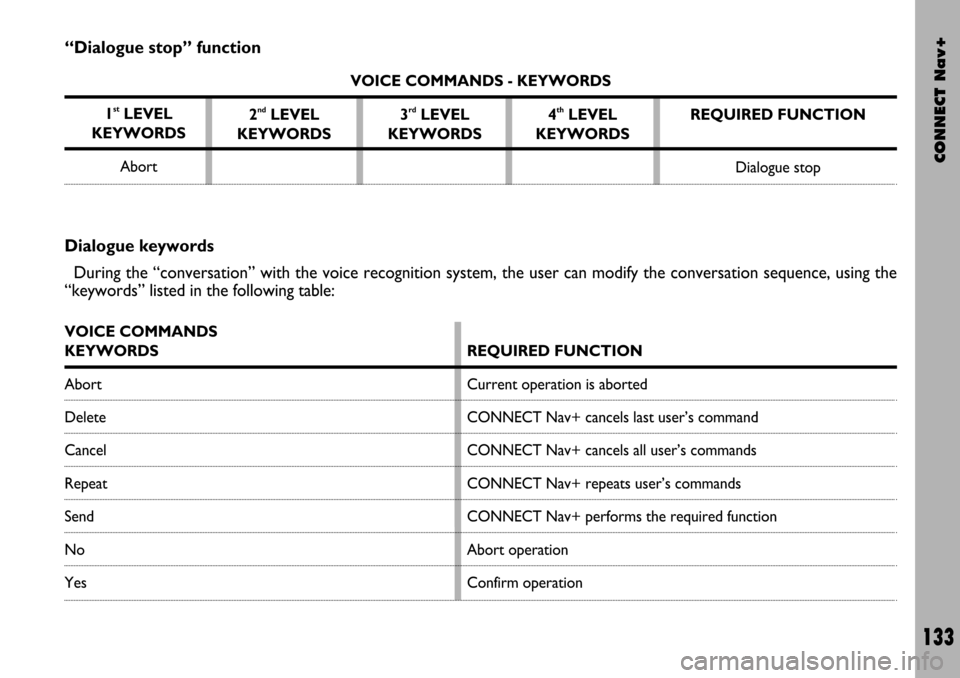
“Dialogue stop” function
VOICE COMMANDS - KEYWORDS
1
stLEVEL
KEYWORDS
Abort2
ndLEVEL
KEYWORDS3rdLEVEL
KEYWORDS4thLEVEL
KEYWORDSREQUIRED FUNCTION
Dialogue stop
Dialogue keywords
During the “conversation” with the voice recognition system, the user can modify the conversation sequence, using the
“keywords” listed in the following table:
VOICE COMMANDS
KEYWORDS
Abort
Delete
Cancel
Repeat
Send
No
Yes
REQUIRED FUNCTION
Current operation is aborted
CONNECT Nav+ cancels last user’s command
CONNECT Nav+ cancels all user’s commands
CONNECT Nav+ repeats user’s commands
CONNECT Nav+ performs the required function
Abort operation
Confirm operation