navigation HONDA CR-V 2008 RD1-RD5, RE7 / 3.G Navigation Manual
[x] Cancel search | Manufacturer: HONDA, Model Year: 2008, Model line: CR-V, Model: HONDA CR-V 2008 RD1-RD5, RE7 / 3.GPages: 145, PDF Size: 4.29 MB
Page 111 of 145
Navigation System111
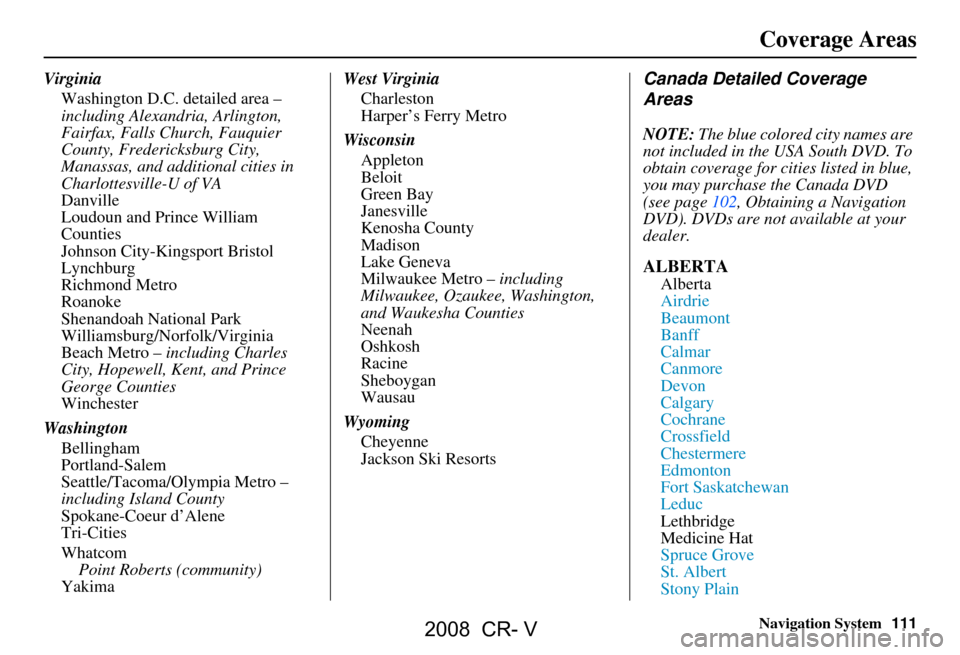
Virginia
Washington D.C. detailed area –
including Alexandria, Arlington,
Fairfax, Falls Church, Fauquier
County, Fredericksburg City,
Manassas, and additional cities in
Charlottesville-U of VA
Danville
Loudoun and Prince William
Counties
Johnson City-Kingsport Bristol
Lynchburg
Richmond Metro
Roanoke
Shenandoah National Park
Williamsburg/Norfolk/Virginia
Beach Metro – including Charles
City, Hopewell, Kent, and Prince
George Counties
Winchester
Washington Bellingham
Portland-Salem
Seattle/Tacoma/Olympia Metro –
including Island County
Spokane-Coeur d’Alene
Tri-Cities
Whatcom
Point Roberts (community)
Yakima West Virginia
Charleston
Harper’s Ferry Metro
Wisconsin Appleton
Beloit
Green Bay
Janesville
Kenosha County
Madison
Lake Geneva
Milwaukee Metro – including
Milwaukee, Ozaukee, Washington,
and Waukesha Counties
Neenah
Oshkosh
Racine
Sheboygan
Wausau
Wyoming Cheyenne
Jackson Ski ResortsCanada Detailed Coverage
Areas
NOTE: The blue colored city names are
not included in the USA South DVD. To
obtain coverage for cities listed in blue,
you may purchase the Canada DVD
(see page102, Obtaining a Navigation
DVD). DVDs are not available at your
dealer.
ALBERTA
Alberta
Airdrie
Beaumont
Banff
Calmar
Canmore
Devon
Calgary
Cochrane
Crossfield
Chestermere
Edmonton
Fort Saskatchewan
Leduc
Lethbridge
Medicine Hat
Spruce Grove
St. Albert
Stony Plain
Coverage Areas
2008 CR- V
Page 112 of 145
112Navigation System
Coverage Areas
Strathcona County
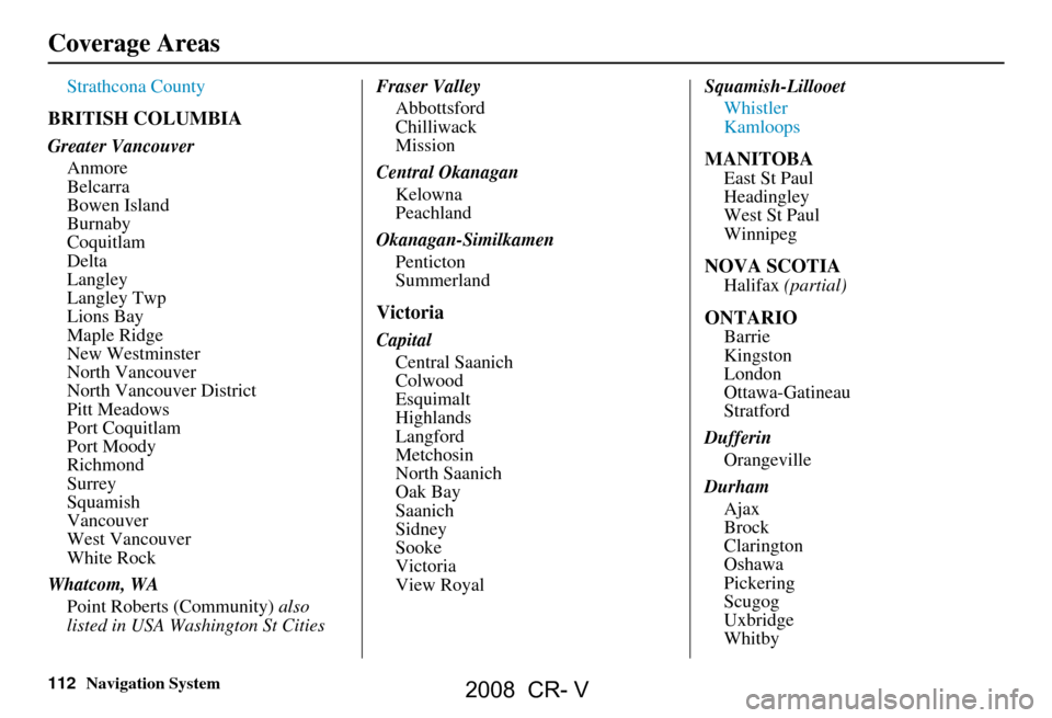
BRITISH COLUMBIA
Greater VancouverAnmore
Belcarra
Bowen Island
Burnaby
Coquitlam
Delta
Langley
Langley Twp
Lions Bay
Maple Ridge
New Westminster
North Vancouver
North Vancouver District
Pitt Meadows
Port Coquitlam
Port Moody
Richmond
Surrey
Squamish
Vancouver
West Vancouver
White Rock
Whatcom, WA Point Roberts (Community) also
listed in USA Washington St Cities Fraser Valley
Abbottsford
Chilliwack
Mission
Central Okanagan Kelowna
Peachland
Okanagan-Similkamen Penticton
Summerland
Victoria
CapitalCentral Saanich
Colwood
Esquimalt
Highlands
Langford
Metchosin
North Saanich
Oak Bay
Saanich
Sidney
Sooke
Victoria
View Royal Squamish-Lillooet
Whistler
Kamloops
MANITOBA
East St Paul
Headingley
West St Paul
Winnipeg
NOVA SCOTIA
Halifax (partial)
ONTARIO
Barrie
Kingston
London
Ottawa-Gatineau
Stratford
Dufferin Orangeville
Durham Ajax
Brock
Clarington
Oshawa
Pickering
Scugog
Uxbridge
Whitby
2008 CR- V
Page 113 of 145
Navigation System113
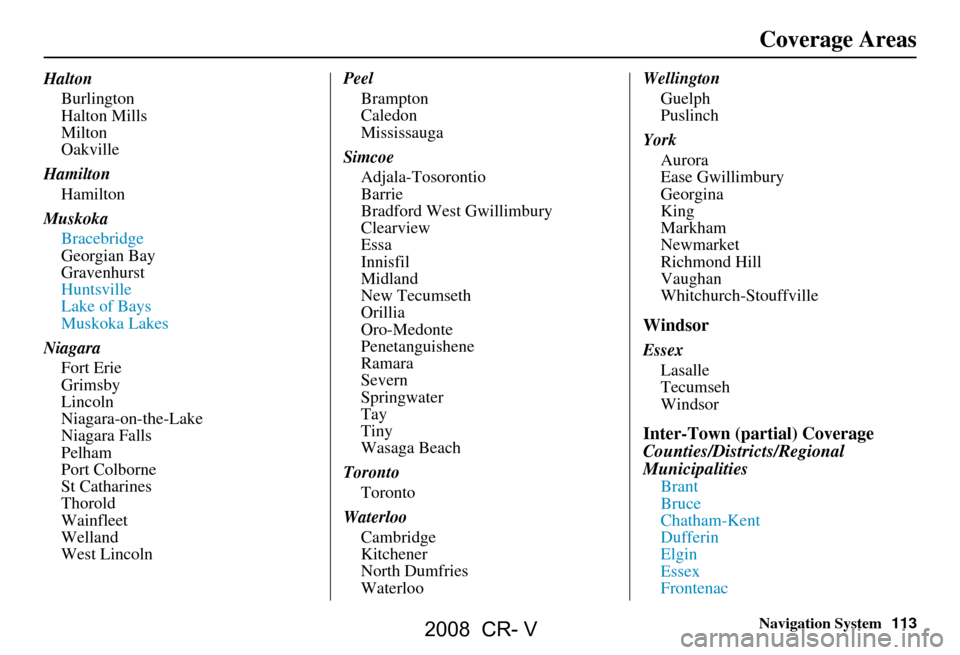
Halton
Burlington
Halton Mills
Milton
Oakville
Hamilton Hamilton
Muskoka Bracebridge
Georgian Bay
Gravenhurst
Huntsville
Lake of Bays
Muskoka Lakes
Niagara Fort Erie
Grimsby
Lincoln
Niagara-on-the-Lake
Niagara Falls
Pelham
Port Colborne
St Catharines
Thorold
Wainfleet
Welland
West Lincoln Peel
Brampton
Caledon
Mississauga
Simcoe Adjala-Tosorontio
Barrie
Bradford West Gwillimbury
Clearview
Essa
Innisfil
Midland
New Tecumseth
Orillia
Oro-Medonte
Penetanguishene
Ramara
Severn
Springwater
Tay
Tiny
Wasaga Beach
Toronto Toronto
Waterloo Cambridge
Kitchener
North Dumfries
Waterloo Wellington
Guelph
Puslinch
York Aurora
Ease Gwillimbury
Georgina
King
Markham
Newmarket
Richmond Hill
Vaughan
Whitchurch-Stouffville
Windsor
EssexLasalle
Tecumseh
Windsor
Inter-Town (partial) Coverage
Counties/Districts/Regional
Municipalities
Brant
Bruce
Chatham-Kent
Dufferin
Elgin
Essex
Frontenac
Coverage Areas
2008 CR- V
Page 114 of 145
114Navigation System
Coverage Areas
Gray
Haldimand-Norfolk
Haliburton
Hastings
Huron
Kawartha Lakes
Lambton
Lanark
Leeds and Granville
Lennox and Addington
Middlesex
Muskoka
Northumberland
Oxford
Perth
Peterborough
Prescott and Russell
Prince Edward
Simcoe
Stormont, Dundas and Glengarry
Waterloo
WellingtonQUÉBEC
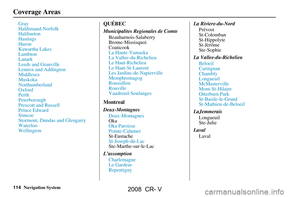
Municipalites Regionales de ComteBeauharnois-Salaberry
Brome-Missisquoi
Coaticook
La Haute-Yamaska
La Vallee-du-Richelieu
Le Haut-Richelieu
Le Haut-St-Laurent
Les Jardins-de-Napierville
Memphremagog
Roussillon
Rouville
Vaudreuil-Soulanges
Montreal
Deux-MontagnesDeux-Montagnes
Oka
Oka Paroisse
Pointe-Calumet
St-Eustache
St-Joseph-du-Lac
Ste-Marthe-sur-le-Lac
L’assomption Charlemagne
Le Gardeur
Repentigny La Rivìere-du-Nord
Prévost
St-Colomban
St-Hippolyte
St-Jèrôme
Ste-Sophie
La Vallee-du-Richelieu Beloeil
Caringnan
Chambly
Longueuil
McMasterville
Mont-St-Hilaire
Otterburn Park
St-Basile-le-Grand
St-Mathieu-de-Beloeil
LaJemmerais Longueuil
Ste-Julie
Laval Laval
2008 CR- V
Page 115 of 145
Navigation System115
Coverage Areas
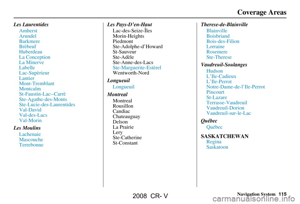
Les Laurentides
Amherst
Arundel
Barkmere
Brèbeuf
Huberdeau
La Conception
La Minerve
Labelle
Lac-Supèrieur
Lantier
Mont-Tremblant
Montcalm
St-Faustin-Lac--Carrè
Ste-Agathe-des-Monts
Ste-Lucie-des-Laurentides
Val-David
Val-des-Lacs
Val-Morin
Les Moulins Lachenaie
Mascouche
Terrebonne Les Pays-D’en-Haut
Lac-des-Seize-Îles
Morin-Heights
Piedmont
Ste-Adolphe-d’Howard
St-Sauveur
Ste-Adèle
Ste-Anne-des-Lacs
Ste-Marguerite-Estèrel
Wentworth-Nord
Longueuil Longueuil
Montreal Montreal
Rousillon
Candiac
Chateauguay
Delson
La Prairie
Lery
Ste-Catherine
St-Constant Therese-de-Blainville
Blainville
Boisbriand
Bois-des-Filion
Lorraine
Rosemere
Ste-Therese
Vaudreuil-Soulanges Hudson
L’Ile-Cadieux
L’Ile-Perrot
Notre-Dame-de-l’Ile-Perrot
Pincourt
St-Lazare
Terrasse-Vaudreuil
Vaudreuil-Dorion
Vaudreuil-sur-le-Lac
Québec Québec
SASKATCHEWAN
Regina
Saskatoon
2008 CR- V
Page 116 of 145
116Navigation System
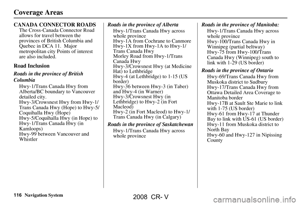
CANADA CONNECTOR ROADS
The Cross-Canada Connector Road
allows for travel between the
provinces of British Columbia and
Quebec in DCA 11. Major
metropolitan city Points of interest
are also included.
Road Inclusion
Roads in the province of British
ColumbiaHwy-1/Trans Canada Hwy from
Alberta/BC boundary to Vancouver
detailed city.
Hwy-3/Crowsnest Hwy from Hwy-1/
Trans Canada Hwy (Hope) to Hwy-5/
Coquihalla Hwy (Hope)
Hwy-5/Coquihalla Hwy (in Hope) to
Hwy-1/Trans Canada Hwy (in
Kamloops)
Hwy-99 between Vancouver and
Whistler Roads in the province of Alberta
Hwy-1/Trans Canada Hwy across
whole province
Hwy-1A from Cochrane to Canmore
Hwy-1X from Hwy-1A to Hwy-1/
Trans Canada Hwy
Morley Road from Hwy-1/Trans
Canada Hwy
Hwy-3/Crowsnest Hwy (at Medicine
Hat) to Lethbridge
Hwy-4 (at Lethbridge) to 1-15 (US
border)
Hwy-36 between Hwy-3 (in Taber)
and Hwy-4 (in Warner)
Hwy-3/Crowsnest Hwy (in
Lethbridge) to Hwy-2 (in Fort
Macleod)
Hwy-2 (in Fort Macleod) to Hwy-1/
Trans Canada Hwy (in Calgary)
Roads in the province of Saskatchewan Hwy-1/Trans Canada Hwy across
whole province Roads in the province of Manitoba:
Hwy-1/Trans Canada Hwy across
whole province
Hwy-100/Trans Canada Hwy in
Winnipeg (partial beltway)
Hwy-75 from Hwy-100/Trans
Canada Hwy (Winnipeg) south to
link with 1-29 (US border)
Roads in the province of Ontario Hwy-69/Trans Canada Hwy from
Muskoka district to Sudbury
Hwy-17/Trans Canada Hwy from
Ottawa Detailed Area Coverage to
Manitoba border
Hwy-17B at Sault Ste Marie to link
with 1-75 (US border)
Hwy-61 from Hwy-17 at Thunder
Bay to link with US-61 (US border)
Hwy-11 from Muskoka district to
North Bay
Hwy-60 and Hwy-127 in Nipissing
County
Coverage Areas
2008 CR- V
Page 117 of 145
Navigation System117
Frequently Asked Questions
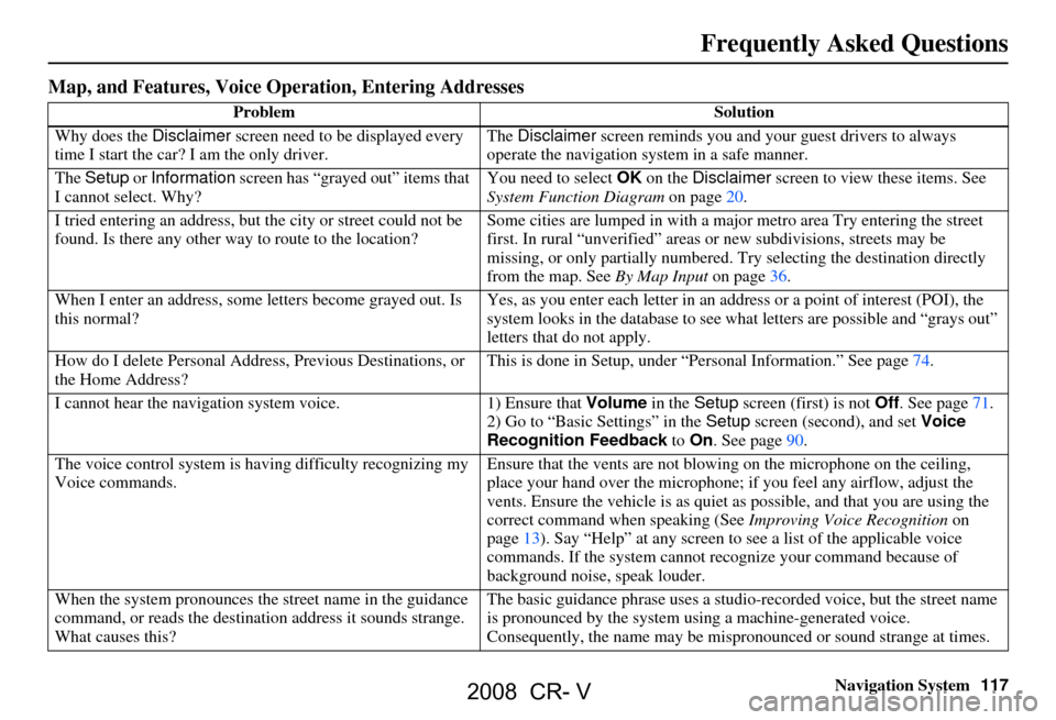
Map, and Features, Voice Oper ation, Entering Addresses
Problem Solution
Why does the Disclaimer screen need to be displayed every
time I start the car? I am the only driver. The
Disclaimer screen reminds you and your guest drivers to always
operate the navigation sy stem in a safe manner.
The Setup or Information screen has “grayed out” items that
I cannot select. Why? You need to select
OK on the Disclaimer screen to view these items. See
System Function Diagram on page20.
I tried entering an address, but th e city or street could not be
found. Is there any other way to route to the location? Some cities are lumped in with a major metro area Try entering the street
first. In rural “unverified” areas
or new subdivisions, streets may be
missing, or only partiall y numbered. Try selecting the destination directly
from the map. See By Map Input on page
36.
When I enter an address, some letters become grayed out. Is
this normal? Yes, as you enter each letter in an addr
ess or a point of interest (POI), the
system looks in the databa se to see what letters are possible and “grays out”
letters that do not apply.
How do I delete Personal Address, Previous Destinations, or
the Home Address? This is done in Setup, under “P
ersonal Information.” See page
74.
I cannot hear the navigation sy stem voice. 1) Ensure that Volume in the Setup screen (first) is not Off. See page
71.
2) Go to “Basic Settings” in the Setup screen (second), and set Voice
Recognition Feedback to On . See page
90.
The voice control system is ha ving difficulty recognizing my
Voice commands. Ensure that the vents are not blow
ing on the microphone on the ceiling,
place your hand over the microphone; if you feel any airflow, adjust the
vents. Ensure the vehicle is as quiet as possible, and that you are using the
correct command when speaking (See Improving Voice Recognition on
page
13). Say “Help ” at any screen to see a list of the applicable voice
commands. If the system cannot r ecognize your command because of
background noise, speak louder.
When the system pronounces the street name in the guidance
command, or reads the destinat ion address it sounds strange.
What causes this? The basic guidance phrase uses a studio
-recorded voice, but the street name
is pronounced by the system us ing a machine-generated voice.
Consequently, the name may be misp ronounced or sound strange at times.
2008 CR- V
Page 118 of 145
118Navigation System
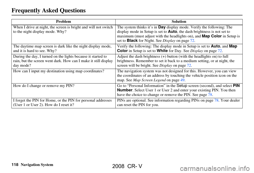
When I drive at night, the screen
is bright and will not switch
to the night display mode. Why? The system thinks it’s in
Day display mode. Verify the following: The
display mode in Setup is set to Auto, the dash brightness is not set to
maximum (must adjust with the headlights on), and Map Color in Setup is
set to Black for Night. See Display on page72.
The daytime map screen is dark like the night display mode,
and it is hard to see. Why? Verify the following: The disp
lay mode in Setup is set to Auto, and Map
Color in Setup is set to White for Day. See Display on page72.
During the day, I turned on the lights because it started to
rain, but the screen went dark. How can I make it still display
day mode? Adjust the dash brightness (+) butt
on (with the headlights on) to full
brightness. Remember to set it back to a medium setting, or at night, the
screen will be bright. See Display on page72.
How can I input my destination using map coordinates? The navigation system was not designed for this. However, you can view
the coordinates of an address by touching the vehicle position icon on the
map. See Map Screen Legend on page49.
How do I change or remove my PIN? Go to “Personal Information” in the Setup screen (second) , and select PIN
Number . Select User 1 or User 2 and enter your existing PIN. You then
have the choice to change or remove the PIN. See page78.
I forget the PIN for Home, or the PIN for personal addresses
(User 1 or User 2). How do I reset it? PINs are optional. See information regarding PINs on page78. Your dealer
can reset the PIN for you.
Problem
Solution
Frequently Asked Questions
2008 CR- V
Page 119 of 145
Navigation System119
Frequently Asked Questions
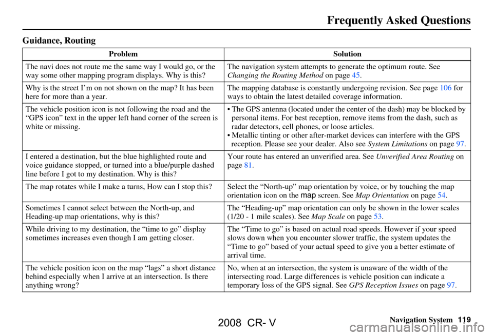
Guidance, Routing
Problem Solution
The navi does not route me the same way I would go, or the
way some other mapping progr am displays. Why is this? The navigation system attempts to
generate the optimum route. See
Changing the Routing Method on page45.
Why is the street I’m on not shown on the map? It has been
here for more than a year. The mapping database is
constantly undergoing revision. See page106 for
ways to obtain the latest de tailed coverage information.
The vehicle position icon is not following the road and the
“GPS icon” text in the upper left hand corner of the screen is
white or missing. The GPS antenna (located under the center of the dash) may be blocked by
personal items. For best reception, remove items from the dash, such as
radar detectors, cell phone s, or loose articles.
Metallic tinting or other after-marke t devices can interfere with the GPS
reception. Please see your dealer. Also see System Limitations on page97.
I entered a destination, but th e blue highlighted route and
voice guidance stopped, or turned into a blue/purple dashed
line before I got to my destination. Why is this? Your route has entered
an unverified area. See Unverified Area Routing on
page81.
The map rotates while I make a turns, Ho w can I stop this? Select the “North-up” ma p orientation by voice, or by touching the map
orientation icon on the map screen. See Map Orientation on page54.
Sometimes I cannot select between the North-up, and
Heading-up map orientations, why is this? The “Heading-up” map orientation can
only be shown in the lower scales
(1/20 - 1 mile scales). See Map Scale on page53.
While driving to my destinati on, the “time to go” display
sometimes increases even though I am getting closer. The “Time to go” is based on actual
road speeds. However if your speed
slows down when you encounter slower traffic, the system updates the
“Time to go” based of your actual spee d to give you a better estimate of
arrival time.
The vehicle position icon on the map “lags” a short distance
behind especially when I arrive at an intersection. Is there
anything wrong? No, when at an intersection, the syst
em is unaware of the width of the
intersecting road. Large differences is vehicle position can indicate a
temporary loss of the GPS signal. See GPS Reception Issues on page97.
2008 CR- V
Page 120 of 145
120Navigation System
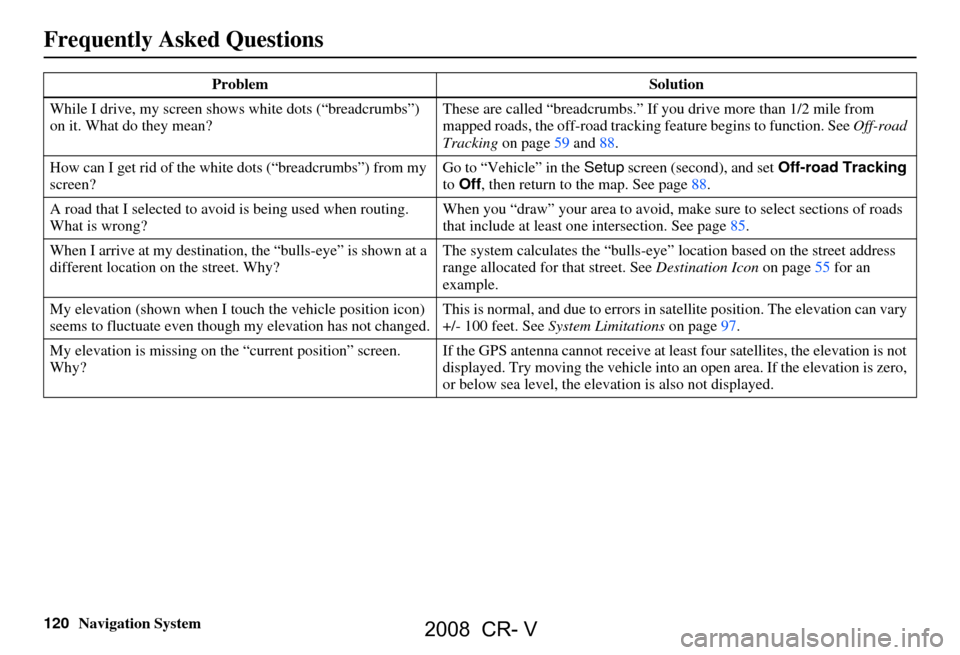
While I drive, my screen s
hows white dots (“breadcrumbs”)
on it. What do they mean? These are called “breadcrumbs.”
If you drive more than 1/2 mile from
mapped roads, the off-road tracking feature begins to function. See Off-road
Tracking on page 59 and 88.
How can I get rid of the whit e dots (“breadcrumbs”) from my
screen? Go to “Vehicle” in the
Setup screen (second), and set Off-road Tracking
to Off , then return to the map. See page 88.
A road that I selected to avoi
d is being used when routing.
What is wrong? When you “draw” your area to avoid, make sure to select sections of roads
that include at least one
intersection. See page 85.
When I arrive at my destination,
the “bulls-eye” is shown at a
different location on the street. Why? The system calculates the “bulls-eye
” location based on the street address
range allocated for that street. See Destination Icon on page 55 fo r an
example.
My elevation (shown when I t ouch the vehicle position icon)
seems to fluctuate even though my elevation has not changed. This is normal, and due to errors in sa
tellite position. The elevation can vary
+/- 100 feet. See System Limitations on page 97.
My elevation is missing on th
e “current position” screen.
Why? If the GPS antenna cannot receive at least four satellites, the elevation is not
displayed. Try moving the vehicle into
an open area. If the elevation is zero,
or below sea level, the elev ation is also not displayed.
Problem
Solution
Frequently Asked Questions
2008 CR- V