navigation system HONDA ELEMENT 2009 1.G Navigation Manual
[x] Cancel search | Manufacturer: HONDA, Model Year: 2009, Model line: ELEMENT, Model: HONDA ELEMENT 2009 1.GPages: 150, PDF Size: 4.16 MB
Page 111 of 150
Navigation System111
Coverage Areas
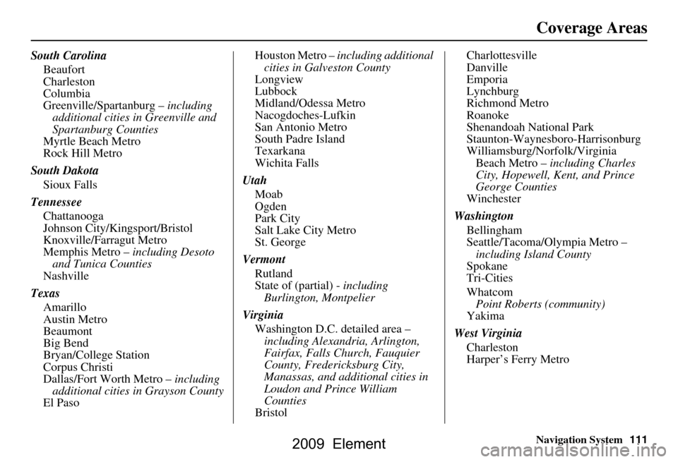
South Carolina
Beaufort
Charleston
Columbia
Greenville/Spartanburg – including
additional cities in Greenville and
Spartanburg Counties
Myrtle Beach Metro
Rock Hill Metro
South Dakota Sioux Falls
Tennessee Chattanooga
Johnson City/Kingsport/Bristol
Knoxville/Farragut Metro
Memphis Metro – including Desoto and Tunica Counties
Nashville
Texas Amarillo
Austin Metro
Beaumont
Big Bend
Bryan/College Station
Corpus Christi
Dallas/Fort Worth Metro – including
additional cities in Grayson County
El Paso Houston Metro –
including additional
cities in Galveston County
Longview
Lubbock
Midland/Odessa Metro
Nacogdoches-Lufkin
San Antonio Metro
South Padre Island
Texarkana
Wichita Falls
Utah Moab
Ogden
Park City
Salt Lake City Metro
St. George
Vermont Rutland
State of (partial) - including
Burlington, Montpelier
Virginia Washington D.C. detailed area – including Alexandria, Arlington,
Fairfax, Falls Church, Fauquier
County, Fredericksburg City,
Manassas, and additional cities in
Loudon and Prince William
Counties
Bristol Charlottesville
Danville
Emporia
Lynchburg
Richmond Metro
Roanoke
Shenandoah National Park
Staunton-Waynesboro-Harrisonburg
Williamsburg/Norfolk/Virginia
Beach Metro – including Charles
City, Hopewell, Kent, and Prince
George Counties
Winchester
Washington Bellingham
Seattle/Tacoma/Olympia Metro – including Island County
Spokane
Tri-Cities
Whatcom
Point Roberts (community)
Yakima
West Virginia Charleston
Harper’s Ferry Metro
2009 Element
Page 112 of 150
112Navigation System
Coverage Areas
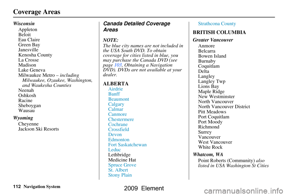
WisconsinAppleton
Beloit
Eau Claire
Green Bay
Janesville
Kenosha County
La Crosse
Madison
Lake Geneva
Milwaukee Metro – including
Milwaukee, Ozaukee, Washington,
and Waukesha Counties
Neenah
Oshkosh
Racine
Sheboygan
Wausau
Wyoming Cheyenne
Jackson Ski ResortsCanada Detailed Coverage
Areas
NOTE:
The blue city names are not included in
the USA South DVD. To obtain
coverage for cities listed in blue, you
may purchase the Canada DVD (see
page103, Obtaining a Navigation
DVD). DVDs are not available at your
dealer.
ALBERTA
Airdrie
Banff
Beaumont
Calgary
Calmar
Canmore
Chestermere
Cochrane
Crossfield
Devon
Edmonton
Fort Saskatchewan
Leduc
Lethbridge
Medicine Hat
Spruce Grove
St. Albert
Stony Plain Strathcona County
BRITISH COLUMBIA
Greater Vancouver
Anmore
Belcarra
Bowen Island
Burnaby
Coquitlam
Delta
Langley
Langley Twp
Lions Bay
Maple Ridge
New Westminster
North Vancouver
North Vancouver District
Pitt Meadows
Port Coquitlam
Port Moody
Richmond
Surrey
Vancouver
West Vancouver
White Rock
Whatcom, WA Point Roberts (Community) also
listed in USA Washington St Cities
2009 Element
Page 113 of 150
Navigation System113
Coverage Areas
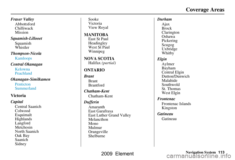
Fraser Valley
Abbottsford
Chilliwack
Mission
Squamish-Lillooet Squamish
Whistler
Thompson-Nicola Kamloops
Central Okanagan Kelowna
Peachland
Okanagan-Similkamen Penticton
Summerland
Victoria
CapitalCentral Saanich
Colwood
Esquimalt
Highlands
Langford
Metchosin
North Saanich
Oak Bay
Saanich
Sidney Sooke
Victoria
View Royal
MANITOBA
East St Paul
Headingley
West St Paul
Winnipeg
NOVA SCOTIA
Halifax
(partial)
ONTARIO
Brant
Brant
Brantford
Chatham-Kent Chatham-Kent
Dufferin Amaranth
East Garafraxa
East Luther Grand Valley
Melancthon
Mono
Mulmur
Orangeville
Shelburne Durham
Ajax
Brock
Clarington
Oshawa
Pickering
Scugog
Uxbridge
Whitby
Elgin Aylmer
Bayham
Central Elgin
Dutton/Dunwich
Malahide
Southwold
St. Thomas
West Elgin
Frontenac Frontenac Islands
Kingston
Gatineau Gatineau
2009 Element
Page 114 of 150
114Navigation System
Coverage Areas
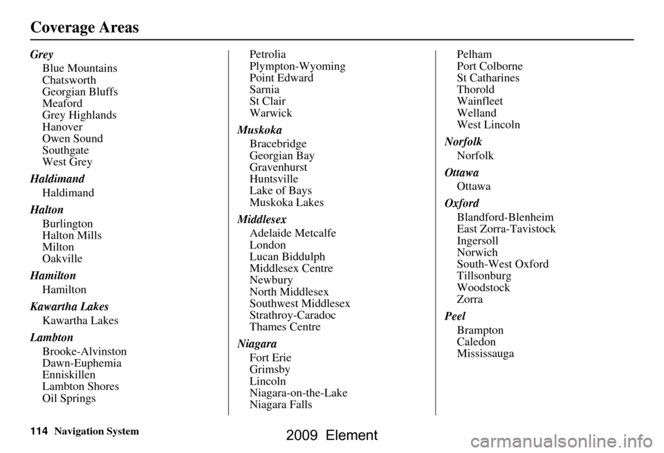
GreyBlue Mountains
Chatsworth
Georgian Bluffs
Meaford
Grey Highlands
Hanover
Owen Sound
Southgate
West Grey
Haldimand Haldimand
Halton Burlington
Halton Mills
Milton
Oakville
Hamilton Hamilton
Kawartha Lakes Kawartha Lakes
Lambton Brooke-Alvinston
Dawn-Euphemia
Enniskillen
Lambton Shores
Oil Springs Petrolia
Plympton-Wyoming
Point Edward
Sarnia
St Clair
Warwick
Muskoka Bracebridge
Georgian Bay
Gravenhurst
Huntsville
Lake of Bays
Muskoka Lakes
Middlesex Adelaide Metcalfe
London
Lucan Biddulph
Middlesex Centre
Newbury
North Middlesex
Southwest Middlesex
Strathroy-Caradoc
Thames Centre
Niagara Fort Erie
Grimsby
Lincoln
Niagara-on-the-Lake
Niagara Falls Pelham
Port Colborne
St Catharines
Thorold
Wainfleet
Welland
West Lincoln
Norfolk Norfolk
Ottawa Ottawa
Oxford Blandford-Blenheim
East Zorra-Tavistock
Ingersoll
Norwich
South-West Oxford
Tillsonburg
Woodstock
Zorra
Peel Brampton
Caledon
Mississauga
2009 Element
Page 115 of 150
Navigation System115
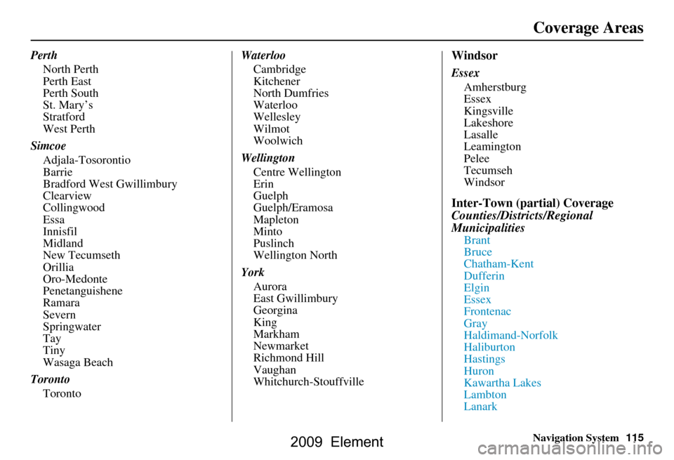
Perth
North Perth
Perth East
Perth South
St. Mary’s
Stratford
West Perth
Simcoe Adjala-Tosorontio
Barrie
Bradford West Gwillimbury
Clearview
Collingwood
Essa
Innisfil
Midland
New Tecumseth
Orillia
Oro-Medonte
Penetanguishene
Ramara
Severn
Springwater
Tay
Tiny
Wasaga Beach
Toronto Toronto Waterloo
Cambridge
Kitchener
North Dumfries
Waterloo
Wellesley
Wilmot
Woolwich
Wellington Centre Wellington
Erin
Guelph
Guelph/Eramosa
Mapleton
Minto
Puslinch
Wellington North
York Aurora
East Gwillimbury
Georgina
King
Markham
Newmarket
Richmond Hill
Vaughan
Whitchurch-StouffvilleWindsor
Essex Amherstburg
Essex
Kingsville
Lakeshore
Lasalle
Leamington
Pelee
Tecumseh
Windsor
Inter-Town (partial) Coverage
Counties/Districts/Regional
Municipalities
Brant
Bruce
Chatham-Kent
Dufferin
Elgin
Essex
Frontenac
Gray
Haldimand-Norfolk
Haliburton
Hastings
Huron
Kawartha Lakes
Lambton
Lanark
Coverage Areas
2009 Element
Page 116 of 150

116Navigation System
Coverage Areas
Leeds and Granville
Lennox and Addington
Middlesex
Muskoka
Northumberland
Oxford
Perth
Peterborough
Prescott and Russell
Prince Edward
Simcoe
Stormont, Dundas, and Glengarry
Waterloo
WellingtonQUÉBEC
Montreal-Laurentians
Deux-MontagnesDeux-Montagnes
Oka
Pointe-Calumet
St-Eustache
St-Joseph-du-Lac
Ste-Marthe-sur-le-Lac
St-Placide
L’Assomption Charlemagne
L’Assomption
L’Èpiphanie
L’Èpiphanie Paroisse
Repentigny
St-Sulpice
La Rivìere-du-Nord Prévost
St-Colomban
St-Hippolyte
St-Jèrôme
Ste-Sophie La Vallee-du-Richelieu
Beloeil
Caringnan
Chambly
McMasterville
Mont-St-Hilaire
Otterburn Park
St-Antoine-sur-Richelieu
St-Basile-le-Grand
St-Charles-sur-Richelieu
St-Denis-sur-Richelieu
St-Jean-Baptiste
St-Marc-sur-Richelieu
St-Mathieu-de-Beloeil
LaJemmerais Calixa-Lavallée
Contrecoeur
St-Amable
Ste-Julie
Varennes
Verchères
Laval Laval
2009 Element
Page 117 of 150
Navigation System117
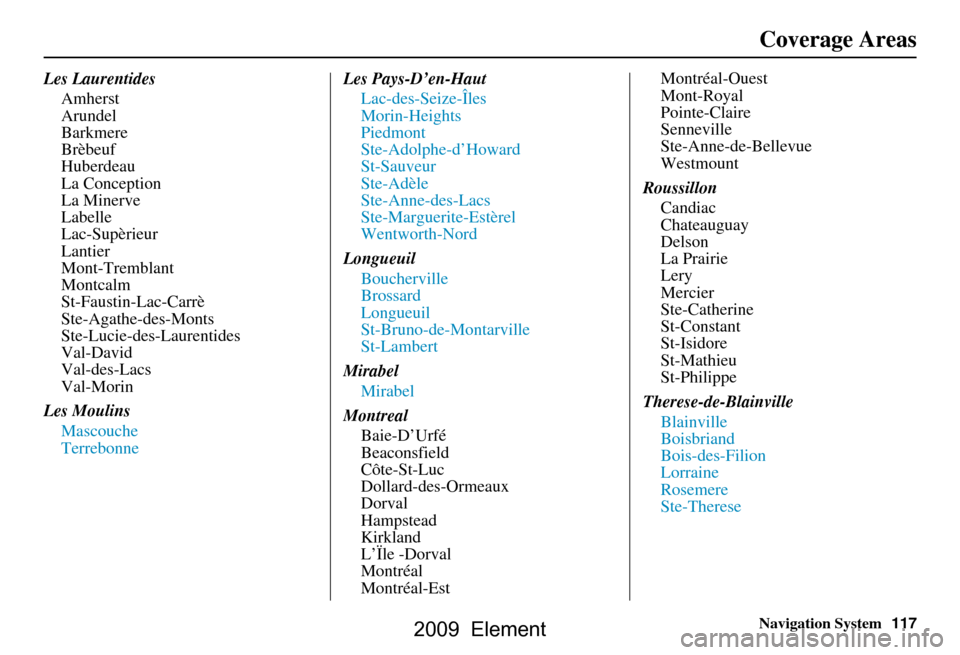
Les Laurentides
Amherst
Arundel
Barkmere
Brèbeuf
Huberdeau
La Conception
La Minerve
Labelle
Lac-Supèrieur
Lantier
Mont-Tremblant
Montcalm
St-Faustin-Lac-Carrè
Ste-Agathe-des-Monts
Ste-Lucie-des-Laurentides
Val-David
Val-des-Lacs
Val-Morin
Les Moulins Mascouche
Terrebonne Les Pays-D’en-Haut
Lac-des-Seize-Îles
Morin-Heights
Piedmont
Ste-Adolphe-d’Howard
St-Sauveur
Ste-Adèle
Ste-Anne-des-Lacs
Ste-Marguerite-Estèrel
Wentworth-Nord
Longueuil Boucherville
Brossard
Longueuil
St-Bruno-de-Montarville
St-Lambert
Mirabel Mirabel
Montreal Baie-D’Urfé
Beaconsfield
Côte-St-Luc
Dollard-des-Ormeaux
Dorval
Hampstead
Kirkland
L’Ïle -Dorval
Montréal
Montréal-Est Montréal-Ouest
Mont-Royal
Pointe-Claire
Senneville
Ste-Anne-de-Bellevue
Westmount
Roussillon Candiac
Chateauguay
Delson
La Prairie
Lery
Mercier
Ste-Catherine
St-Constant
St-Isidore
St-Mathieu
St-Philippe
Therese-de-Blainville Blainville
Boisbriand
Bois-des-Filion
Lorraine
Rosemere
Ste-Therese
Coverage Areas
2009 Element
Page 118 of 150
118Navigation System
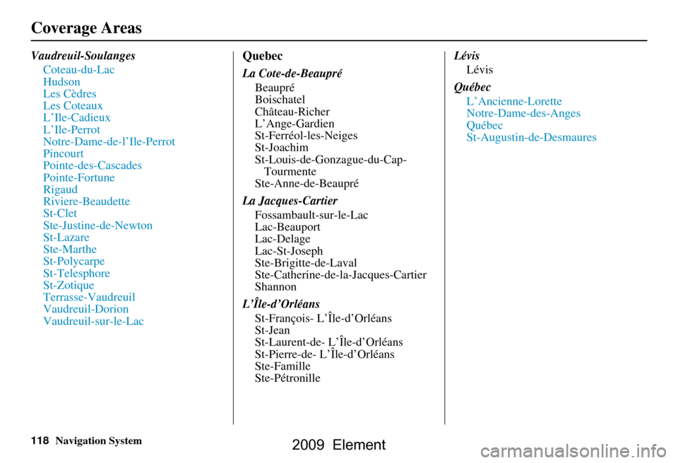
Vaudreuil-SoulangesCoteau-du-Lac
Hudson
Les Cèdres
Les Coteaux
L’Ile-Cadieux
L’Ile-Perrot
Notre-Dame-de-l’Ile-Perrot
Pincourt
Pointe-des-Cascades
Pointe-Fortune
Rigaud
Riviere-Beaudette
St-Clet
Ste-Justine-de-Newton
St-Lazare
Ste-Marthe
St-Polycarpe
St-Telesphore
St-Zotique
Terrasse-Vaudreuil
Vaudreuil-Dorion
Vaudreuil-sur-le-LacQuebec
La Cote-de-BeaupréBeaupré
Boischatel
Château-Richer
L’Ange-Gardien
St-Ferréol-les-Neiges
St-Joachim
St-Louis-de-Gonzague-du-Cap-Tourmente
Ste-Anne-de-Beaupré
La Jacques-Cartier Fossambault-sur-le-Lac
Lac-Beauport
Lac-Delage
Lac-St-Joseph
Ste-Brigitte-de-Laval
Ste-Catherine-de-l a-Jacques-Cartier
Shannon
L’Île-d’Orléans St-François- L’Île-d’Orléans
St-Jean
St-Laurent-de- L’Île-d’Orléans
St-Pierre-de- L’Île-d’Orléans
Ste-Famille
Ste-Pétronille Lévis
Lévis
Québec L’Ancienne-Lorette
Notre-Dame-des-Anges
Québec
St-Augustin-de-Desmaures
Coverage Areas
2009 Element
Page 119 of 150
Navigation System119
Coverage Areas
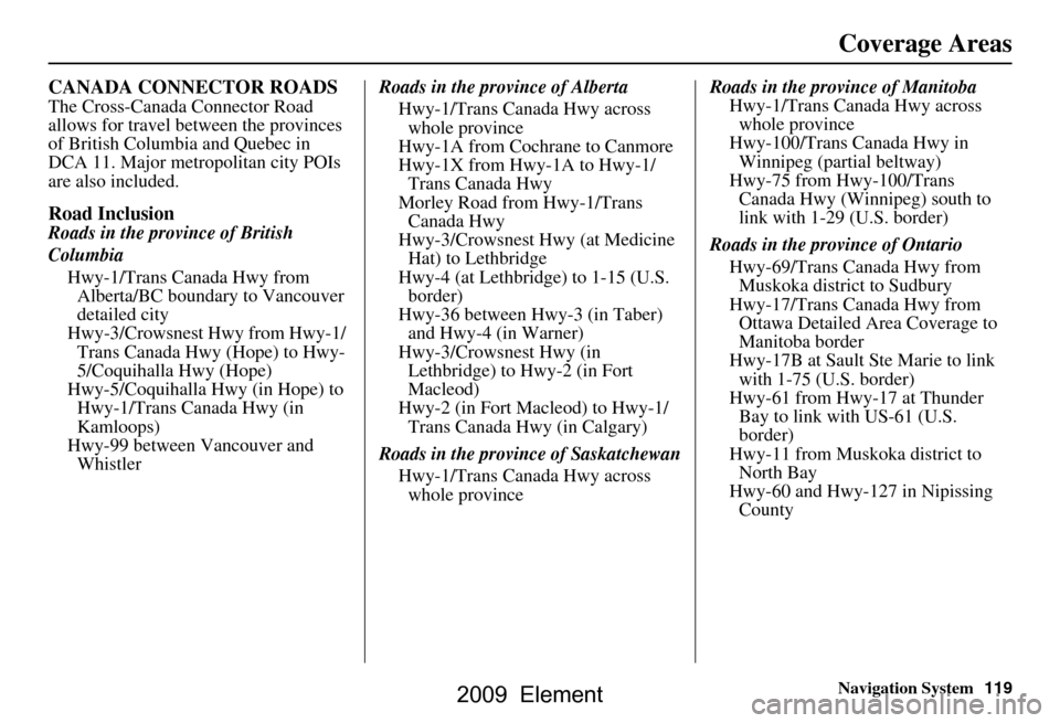
CANADA CONNECTOR ROADS
The Cross-Canada Connector Road
allows for travel between the provinces
of British Columbia and Quebec in
DCA 11. Major metropolitan city POIs
are also included.
Road Inclusion
Roads in the province of British
Columbia
Hwy-1/Trans Canada Hwy from Alberta/BC boundary to Vancouver
detailed city
Hwy-3/Crowsnest Hwy from Hwy-1/ Trans Canada Hwy (Hope) to Hwy-
5/Coquihalla Hwy (Hope)
Hwy-5/Coquihalla Hwy (in Hope) to Hwy-1/Trans Canada Hwy (in
Kamloops)
Hwy-99 between Vancouver and Whistler Roads in the province of Alberta
Hwy-1/Trans Canada Hwy across whole province
Hwy-1A from Cochrane to Canmore
Hwy-1X from Hwy-1A to Hwy-1/ Trans Canada Hwy
Morley Road from Hwy-1/Trans Canada Hwy
Hwy-3/Crowsnest Hwy (at Medicine Hat) to Lethbridge
Hwy-4 (at Lethbridge) to 1-15 (U.S. border)
Hwy-36 between Hwy-3 (in Taber) and Hwy-4 (in Warner)
Hwy-3/Crowsnest Hwy (in Lethbridge) to Hwy-2 (in Fort
Macleod)
Hwy-2 (in Fort Macleod) to Hwy-1/ Trans Canada Hwy (in Calgary)
Roads in the province of Saskatchewan Hwy-1/Trans Canada Hwy across whole province Roads in the province of Manitoba
Hwy-1/Trans Canada Hwy across whole province
Hwy-100/Trans Canada Hwy in Winnipeg (partial beltway)
Hwy-75 from Hwy-100/Trans Canada Hwy (Winnipeg) south to
link with 1-29 (U.S. border)
Roads in the province of Ontario Hwy-69/Trans Canada Hwy from Muskoka district to Sudbury
Hwy-17/Trans Canada Hwy from Ottawa Detailed Area Coverage to
Manitoba border
Hwy-17B at Sault Ste Marie to link with 1-75 (U.S. border)
Hwy-61 from Hwy-17 at Thunder Bay to link with US-61 (U.S.
border)
Hwy-11 from Muskoka district to North Bay
Hwy-60 and Hwy-127 in Nipissing County
2009 Element
Page 120 of 150
120Navigation System
Coverage Areas
Operation in Alaska and
Hawaii
Certain functions that rely on a satellite
signal will not work in Alaska and
Hawaii. These functions include but are
not limited to XM radio, automatic
clock updates, and time zone
adjustments.
Alaska
If the vehicle was purchased in the
lower 48 states and driven to Alaska, the
system cannot display maps. The
message “Vehicle is out of the
database...” will be displayed.
Hawaii
This section describes the differences in
navigation system operation for vehicles
delivered in Hawaii.
Map Coverage
All roads displayed on the Hawaii map
screens are detailed coverage roads.
Text related to “unverified” roads or
areas are not applicable. The following
topics do not apply in Hawaii:
Unverified road descriptions (see page
6 and 82 ).
Cautions and pop-up windows related to unverified roads (see page
61).
Setup entries that relate to turning on
or off unverified routing (see
page
83 ).
When zooming in and out, there is no 350-mile scale for Hawaii.
Other Map Issues
See the coverage section for a list of islands with coverage (see page
107).
Freeway Exit information does not exist in Hawaii, so the “Freeway Exit
Info” icon is not shown on the icon
bar.
Address and POI Entry Screens
When in Hawaii, the following
differences occur for map, address, and
POI selection:
It is not possible to enter U.S. mainland addresses or scroll the map
east to the U.S. mainland.
Selection of the “State” is confined to the state of Hawaii only.
Entry of a destination address or POI on an island other than your current
island may result in a screen caution
message. This is normal because
there are no “ferry” routes between
islands available in the database.
If the “Guidance Prompts” setting on the Setup screen is set to normal or
maximum, street names will not be
spoken in voice guidance commands.
2009 Element