page 92 HONDA ELEMENT 2009 1.G Navigation Manual
[x] Cancel search | Manufacturer: HONDA, Model Year: 2009, Model line: ELEMENT, Model: HONDA ELEMENT 2009 1.GPages: 150, PDF Size: 4.16 MB
Page 103 of 150
Navigation System103
Customer Assistance
Visiting Your Dealer
We strive to make this manual as
complete as possible and to answer all
questions regarding operation of the
system. Occasionally, you may run into
a specific issue that you cannot find in
the book. You may save yourself a trip
to the dealer by fi rst consulting the
following resources:
The Troubleshooting section (see page132).
The Frequently Asked Questions (FAQs) section (see page122).
The FAQs found on the online DVD order site (see “Obtaining a DVD”).
For detailed questions regarding audio or other systems that interact
with the navigation system, see the
main vehicle Owner’s manual or the
Quick Start Guide. Call Honda Customer Relations (see
“Honda Automobile Customer
Service” on page102).
For database or PO I issues, follow the
guidelines in the “Reporting Errors”
section (see page102).
If your question is still unanswered and
you wish to visit the dealer, please be
prepared to demonstrate the issue to the
service advisor. This way, the service
advisor can document the issue for the
factory to allow more efficient
troubleshooting.
Some issues may at first seem random,
but you may notice a pattern. For
example, they only occur when you
enter a specific address, or when driving
on a certain road, or just when it is cold.
This information is very useful to the
service advisor. Be patient, the service
advisor may be unfamiliar with your
specific issue.
Obtaining a Navigation
Update DVD
Honda is continually expanding the
scope of the navigation system.
Upgraded software may be made
available to navigation system owners
periodically, usually in the fall of each
year.
To purchase an updated DVD or a
replacement DVD, call the Honda
Navigation Disc Fulfillment Center at
(888) 291-4675. You can also order
online by going to
www.hondanavi.com.
NOTE:
DVDs are not available at your dealer. However, the dealer may
order a DVD for you as a courtesy.
There is no program for free DVD
updates.
The DVD order line staff cannot answer technical questions regarding
navigation operation, coverage, or
POIs.
Purchasing used discs from alternate sources or online auctions may cause
operational problems since they are
likely to be incompatible with your
current software.
2009 Element
Page 105 of 150
Navigation System105
Customer Assistance
PC Card Operation
A PC card with WMA or MP3 audio
files can be played through the audio
system and controlled using the
navigation voice control system. PC
card (PCMCIA) adaptors and various
media chips can be purchased at any
computer store. Tested media chips
include Compact Flash and SD media,
up to 2GB. Other media types and
storage capacities may work, but have
not been tested. Hard disc drive type
media are not recommended because
they can fail in a hot vehicle. See the
FAQs section for additional
information.
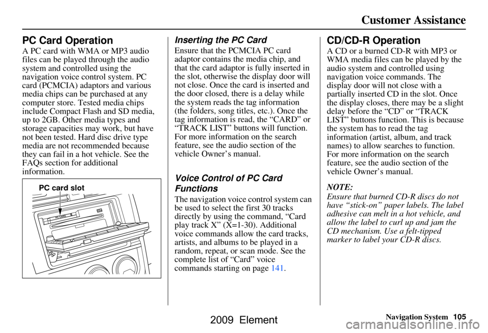
Inserting the PC Card
Ensure that the PCMCIA PC card
adaptor contains the media chip, and
that the card adaptor is fully inserted in
the slot, otherwise the display door will
not close. Once the card is inserted and
the door closed, ther e is a delay while
the system reads the tag information
(the folders, song titles, etc.). Once the
tag information is read, the “CARD” or
“TRACK LIST” buttons will function.
For more information on the search
feature, see the audio section of the
vehicle Owner’s manual.
Voice Control of PC Card
Functions
The navigation voice control system can
be used to select the first 30 tracks
directly by using the command, “Card
play track X” (X=1-30). Additional
voice commands allow the card tracks,
artists, and albums to be played in a
random, repeat, or scan mode. See the
complete list of “Card” voice
commands starting on page141.
CD/CD-R Operation
A CD or a burned CD-R with MP3 or
WMA media files can be played by the
audio system and controlled using
navigation voice commands. The
display door will not close with a
partially inserted CD in the slot. Once
the display closes, there may be a slight
delay before the “CD” or “TRACK
LIST” buttons function. This is because
the system has to read the tag
information (artist, album, and track
names) to allow searches to function.
For more information on the search
feature, see the audio section of the
vehicle Owner’s manual.
NOTE:
Ensure that burned CD-R discs do not
have “stick-on” paper labels. The label
adhesive can melt in a hot vehicle, and
allow the label to curl up and jam the
CD mechanism. Use a felt-tipped
marker to label your CD-R discs.
PC card slot
2009 Element
Page 106 of 150
106Navigation System
Customer Assistance
Voice Control of CD Functions
The navigation voice control system can
be used to select the first 30 tracks
directly by using the command, “CD
play track X” (X=1-30). Additional
voice commands allow CD tracks, and
folders be played in a random, repeat, or
scan mode. See the complete list of
“CD” voice commands starting on
page141.
2009 Element
Page 107 of 150
Navigation System107
Coverage Areas
Map Coverage
The system provides map coverage for
the lower 48 U.S. states, Hawaii, and
southern Canada. The U.S. map
coverage consists of accurately mapped
(verified) metropolitan areas (in the
following list) and a less accurate
(unverified) rural database. Canada
coverage consists of major metropolitan
areas and major roads connecting the
metropolitan areas within about 100
miles north of the U.S. border. If you
need additional northern Canada
coverage, you may purchase the
Canadian DVD (see Obtaining a
Navigation Update DVD on page103).
See Map Overview on page6 for a
discussion of map coverage.
The cities and metropolitan areas in the
following list are fully mapped. Only
major streets, roads, and freeways have
been verified outside these areas. If your
route passes through these areas, routing
may be limited, depending on your
routing choices. See Unverified Area
Routing on page82. If you desire additional map coverage
information, contact Honda Customer
Services or go to
www.hondanavi.com.
U.S. Detailed Coverage Areas
Alabama
Birmingham/Tuscaloosa
Huntsville
Mobile
Montgomery
Arizona Phoenix Metro
Sedona
Tucson
Yuma
Arkansas Fayetteville
Fort Smith
Hot Springs
Little Rock
California Central Valley - including Fresno, Merced, Modesto, and Stockton
Humboldt
Los Angeles/San Diego Metro
Mammoth Lakes
Sacramento Metro San Francisco Bay
(approximately
Monterey to Sonoma) – including
Monterey County and Hollister
Southern California Area - including
Bakersfield and San Luis Obispo
Yuba
Colorado Denver/Boulder/Colorado Springs/ Ski Resorts Metro area – including
Ft. Collins
Grand Junction
Connecticut Bridgeport
Danbury
Hartford Metro
New Haven Metro
Norwalk
Stamford
Delaware Entire state – including Dover,
Wilmington Metro area, New
Castle County
2009 Element
Page 112 of 150
112Navigation System
Coverage Areas
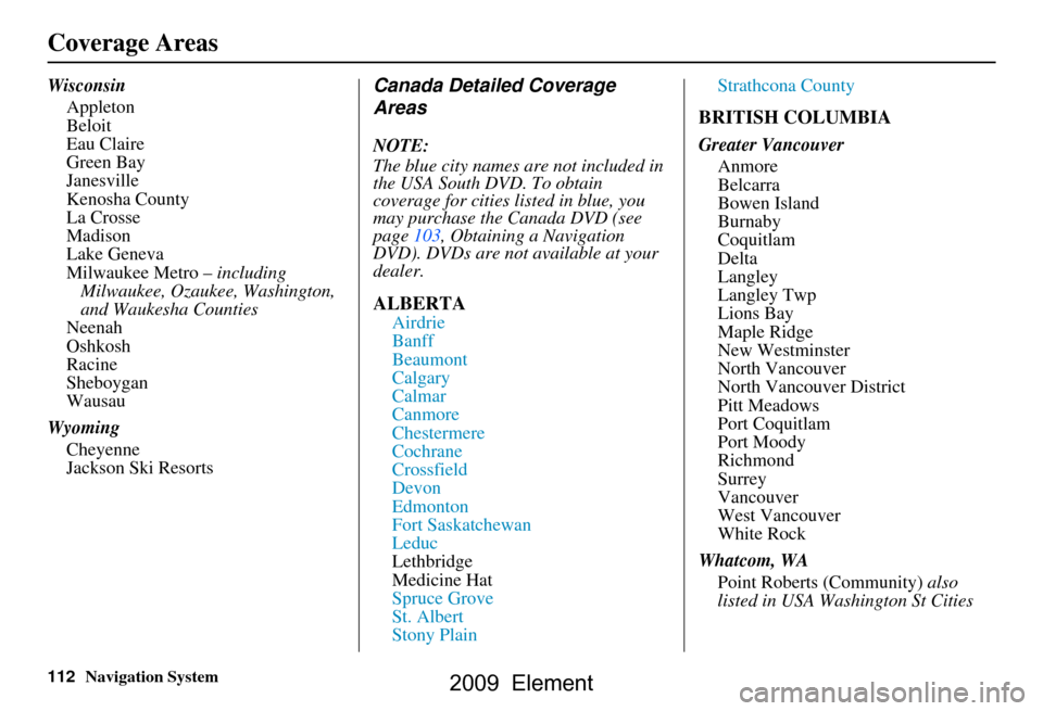
WisconsinAppleton
Beloit
Eau Claire
Green Bay
Janesville
Kenosha County
La Crosse
Madison
Lake Geneva
Milwaukee Metro – including
Milwaukee, Ozaukee, Washington,
and Waukesha Counties
Neenah
Oshkosh
Racine
Sheboygan
Wausau
Wyoming Cheyenne
Jackson Ski ResortsCanada Detailed Coverage
Areas
NOTE:
The blue city names are not included in
the USA South DVD. To obtain
coverage for cities listed in blue, you
may purchase the Canada DVD (see
page103, Obtaining a Navigation
DVD). DVDs are not available at your
dealer.
ALBERTA
Airdrie
Banff
Beaumont
Calgary
Calmar
Canmore
Chestermere
Cochrane
Crossfield
Devon
Edmonton
Fort Saskatchewan
Leduc
Lethbridge
Medicine Hat
Spruce Grove
St. Albert
Stony Plain Strathcona County
BRITISH COLUMBIA
Greater Vancouver
Anmore
Belcarra
Bowen Island
Burnaby
Coquitlam
Delta
Langley
Langley Twp
Lions Bay
Maple Ridge
New Westminster
North Vancouver
North Vancouver District
Pitt Meadows
Port Coquitlam
Port Moody
Richmond
Surrey
Vancouver
West Vancouver
White Rock
Whatcom, WA Point Roberts (Community) also
listed in USA Washington St Cities
2009 Element
Page 120 of 150
120Navigation System
Coverage Areas
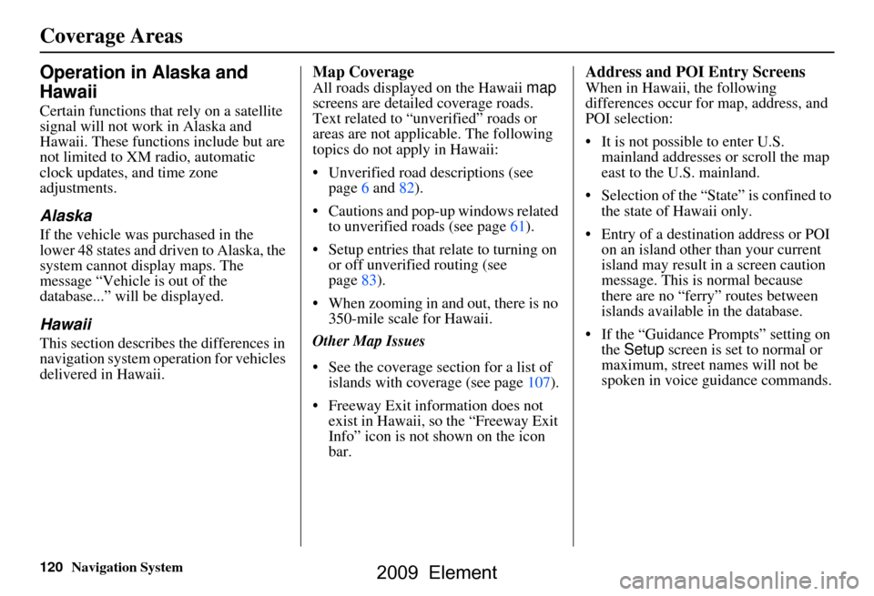
Operation in Alaska and
Hawaii
Certain functions that rely on a satellite
signal will not work in Alaska and
Hawaii. These functions include but are
not limited to XM radio, automatic
clock updates, and time zone
adjustments.
Alaska
If the vehicle was purchased in the
lower 48 states and driven to Alaska, the
system cannot display maps. The
message “Vehicle is out of the
database...” will be displayed.
Hawaii
This section describes the differences in
navigation system operation for vehicles
delivered in Hawaii.
Map Coverage
All roads displayed on the Hawaii map
screens are detailed coverage roads.
Text related to “unverified” roads or
areas are not applicable. The following
topics do not apply in Hawaii:
Unverified road descriptions (see page
6 and 82 ).
Cautions and pop-up windows related to unverified roads (see page
61).
Setup entries that relate to turning on
or off unverified routing (see
page
83 ).
When zooming in and out, there is no 350-mile scale for Hawaii.
Other Map Issues
See the coverage section for a list of islands with coverage (see page
107).
Freeway Exit information does not exist in Hawaii, so the “Freeway Exit
Info” icon is not shown on the icon
bar.
Address and POI Entry Screens
When in Hawaii, the following
differences occur for map, address, and
POI selection:
It is not possible to enter U.S. mainland addresses or scroll the map
east to the U.S. mainland.
Selection of the “State” is confined to the state of Hawaii only.
Entry of a destination address or POI on an island other than your current
island may result in a screen caution
message. This is normal because
there are no “ferry” routes between
islands available in the database.
If the “Guidance Prompts” setting on the Setup screen is set to normal or
maximum, street names will not be
spoken in voice guidance commands.
2009 Element
Page 121 of 150
Navigation System121
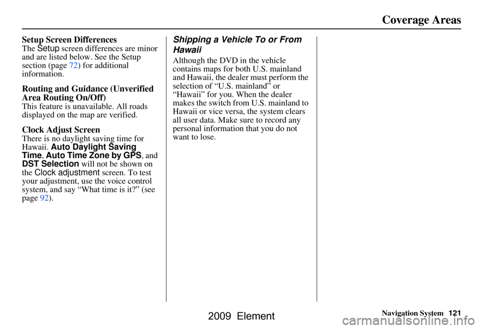
Setup Screen Differences
The Setup screen differences are minor
and are listed belo w. See the Setup
section (page72) for additional
information.
Routing and Guidan ce (Unverified
Area Routing On/Off)
This feature is unavailable. All roads
displayed on the map are verified.
Clock Adjust Screen
There is no daylight saving time for
Hawaii. Auto Daylight Saving
Time, Auto Time Zone by GPS , and
DST Selection will not be shown on
the Clock adjustment screen. To test
your adjustment, use the voice control
system, and say “What time is it?” (see
page92).
Shipping a Vehicle To or From
Hawaii
Although the DVD in the vehicle
contains maps for both U.S. mainland
and Hawaii, the dealer must perform the
selection of “U.S. mainland” or
“Hawaii” for you. When the dealer
makes the switch from U.S. mainland to
Hawaii or vice versa, the system clears
all user data. Make sure to record any
personal information that you do not
want to lose.
Coverage Areas
2009 Element
Page 122 of 150
122Navigation System
Frequently Asked Questions
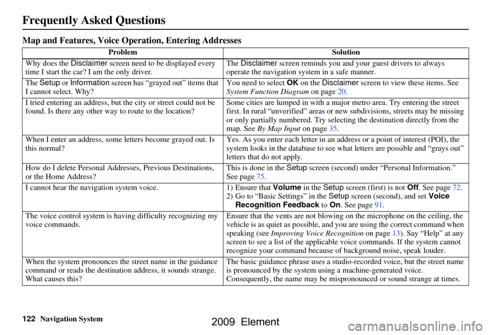
Map and Features, Voice Operation, Entering Addresses
Problem Solution
Why does the Disclaimer screen need to be displayed every
time I start the car? I am the only driver. The
Disclaimer screen reminds you and your guest drivers to always
operate the navigation sy stem in a safe manner.
The Setup or Information screen has “grayed out” items that
I cannot select. Why? You need to select
OK on the Disclaimer screen to view these items. See
System Function Diagram on page20.
I tried entering an address, but th e city or street could not be
found. Is there any other way to route to the location? Some cities are lumped in with a major metro area. Try entering the street
first. In rural “unverified” areas or ne
w subdivisions, streets may be missing
or only partially numbered. Try selecting the destin ation directly from the
map. See By Map Input on page35.
When I enter an address, some letters become grayed out. Is
this normal? Yes. As you enter each letter in an addr
ess or a point of interest (POI), the
system looks in the databa se to see what letters are possible and “grays out”
letters that do not apply.
How do I delete Personal Addre sses, Previous Destinations,
or the Home Address? This is done in the
Setup screen (second) under “P ersonal Information.”
See page
75.
I cannot hear the navigation system voice. 1) Ensure that Volume in the Setup screen (first) is not Off. See page
72.
2) Go to “Basic Settings” in the Setup screen (second), and set Voice
Recognition Feedback to On . See page
91.
The voice control system is ha ving difficulty recognizing my
voice commands. Ensure that the vents are not blowi
ng on the microphone on the ceiling, the
vehicle is as quiet as possible, and you are using the correct command when
speaking (see Improving Voice Recognition on page
13). Say “Help” at any
screen to see a list of the applicable voice commands. If the system cannot
recognize your command because of background noise, speak louder.
When the system pronounces the street name in the guidance
command or reads the destinati on address, it sounds strange.
What causes this? The basic guidance phrase uses a studio
-recorded voice, but the street name
is pronounced by the system us ing a machine-generated voice.
Consequently, the name may be misp ronounced or sound strange at times.
2009 Element
Page 123 of 150
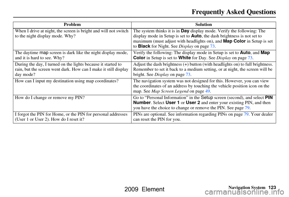
Navigation System123
When I drive at night, the screen
is bright and will not switch
to the night display mode. Why? The system thinks it is in
Day display mode. Verify the following: The
display mode in Setup is set to Auto, the dash brightness is not set to
maximum (must adjust with headlights on), and Map Color in Setup is set
to Black for Night. See Display on page73.
The daytime map screen is dark like the night display mode,
and it is hard to see. Why? Verify the following: The disp
lay mode in Setup is set to Auto, and Map
Color in Setup is set to White for Day. See Display on page73.
During the day, I turned on the lights because it started to
rain, but the screen went dark. How can I make it still display
day mode? Adjust the dash brightness (+) button
(with headlights on) to full brightness.
Remember to set it back to a medium set ting, or at night, the screen will be
bright. See Display on page73.
How can I input my destination using map coordinates? The navigation system was not designed for this. However, you can view
the coordinates of an address by touching the vehicle position icon on the
map. See Map Screen Legend on page49.
How do I change or remove my PIN? Go to “Personal Information” in the Setup screen (second) , and select PIN
Number . Select User 1 or User 2 and enter your existing PIN, and then
you have the choice to change or remove the PIN. See page79.
I forgot the PIN for Home, or the PIN for personal addresses
(User 1 or User 2). How do I reset it? PINs are optional. See information regarding PINs on page79. Your dealer
can reset the PIN for you.
Problem
Solution
Frequently Asked Questions
2009 Element
Page 124 of 150
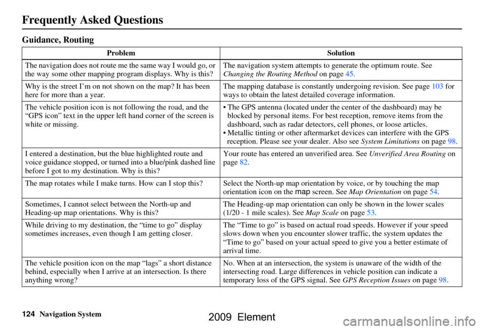
124Navigation System
Frequently Asked Questions
Guidance, Routing
ProblemSolution
The navigation does not route me the same way I would go, or
the way some other mapping program displays. Why is this? The navigation system attempts to
generate the optimum route. See
Changing the Routing Method on page45.
Why is the street I’m on not shown on the map? It has been
here for more than a year. The mapping database is
constantly undergoing revision. See page103 for
ways to obtain the latest de tailed coverage information.
The vehicle position icon is not following the road, and the
“GPS icon” text in the upper left hand corner of the screen is
white or missing. The GPS antenna (located under the center of the dashboard) may be
blocked by personal items. For best reception, remove items from the
dashboard, such as radar detector s, cell phones, or loose articles.
Metallic tinting or other aftermarke t devices can interfere with the GPS
reception. Please see your dealer. Also see System Limitations on page98.
I entered a destination, but th e blue highlighted route and
voice guidance stopped, or turned into a blue/pink dashed line
before I got to my dest ination. Why is this? Your route has entered
an unverified area. See Unverified Area Routing on
page82.
The map rotates while I make turns. How can I stop this? Select the North-up map orientation by voice, or by touching the map
orientation icon on the map screen. See Map Orientation on page54.
Sometimes, I cannot select between the North-up and
Heading-up map orienta tions. Why is this? The Heading-up map orient
ation can only be shown in the lower scales
(1/20 - 1 mile scales). See Map Scale on page53.
While driving to my destinati on, the “time to go” display
sometimes increases, even though I am getting closer. The “Time to go” is based on actual
road speeds. However if your speed
slows down when you encounter slower traffic, the system updates the
“Time to go” based on your actual spee d to give you a better estimate of
arrival time.
The vehicle position icon on the map “lags” a short distance
behind, especially when I arrive at an intersection. Is there
anything wrong? No. When at an intersection, the syst
em is unaware of the width of the
intersecting road. Large differences in vehicle position can indicate a
temporary loss of the GPS signal. See GPS Reception Issues on page98.
2009 Element