Tail light HONDA ODYSSEY 2008 RB1-RB2 / 3.G Navigation Manual
[x] Cancel search | Manufacturer: HONDA, Model Year: 2008, Model line: ODYSSEY, Model: HONDA ODYSSEY 2008 RB1-RB2 / 3.GPages: 148, PDF Size: 7.91 MB
Page 6 of 148
6Navigation System
While driving, do not look at the screen
or operate the system controls for more
than a second or so at a time, and only
after deciding you can do so safely. Pull
to the side of the road if you need more
time to look at the screen or operate the
controls. The navigation system is designed to
provide route information to help you
reach your destination. However, this
route guidance may sometimes conflict
with current road conditions such as
street closures, road construction,
detours, and out-of-date map data.
Additionally, the system itself has
certain limitations (see page
103).
Therefore, you must verify the audio
and visual route information provided
by the system by caref
ully observing the
roadway, signs and signals, etc. If you
are unsure, proceed with caution.
Always use your own good judgment,
and obey traffic laws while driving.
Map Overview
Current Street
The current street on which your vehicle
is, appears at the bottom of the map
screen (see page
20 ). A message saying
“Not on a digitized road” may appear
instead when you driv e half a mile away
from a mapped road. For more details,
see Off-road Tracking on page
62.
Verified/Unverified Street
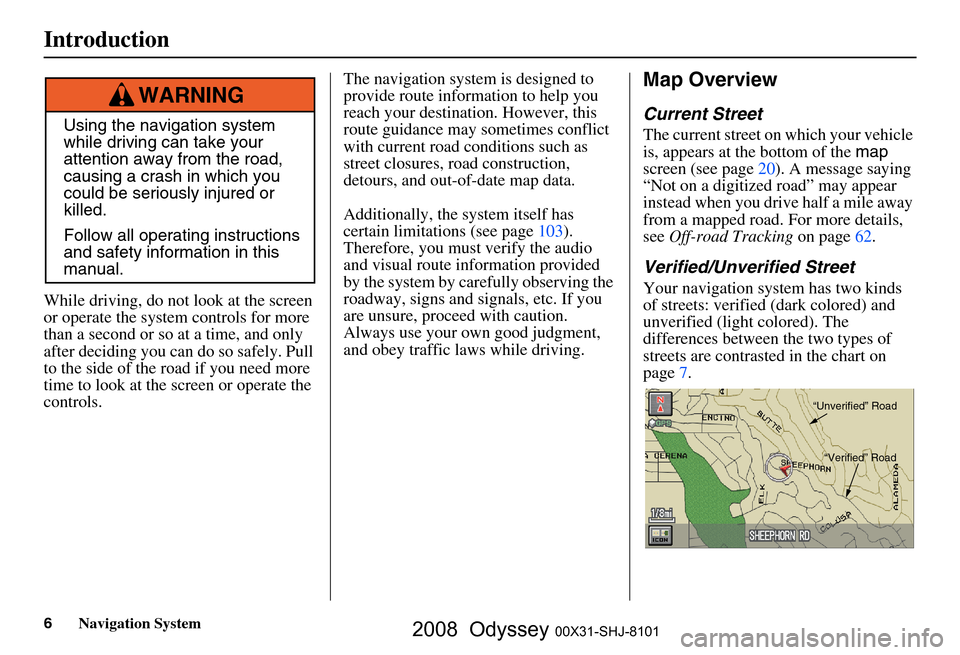
Your navigation system has two kinds
of streets: verified (dark colored) and
unverified (light colored). The
differences between the two types of
streets are contrasted in the chart on
page7.
Using the navigation system
while driving can take your
attention away from the road,
causing a crash in which you
could be seriously injured or
killed.
Follow all operating instructions
and safety information in this
manual.
WARNING
“Unverified” Road“Verified” Road
Introduction
2008 Odyssey 00X31-SHJ-8101
Page 11 of 148
Navigation System11
Getting Started
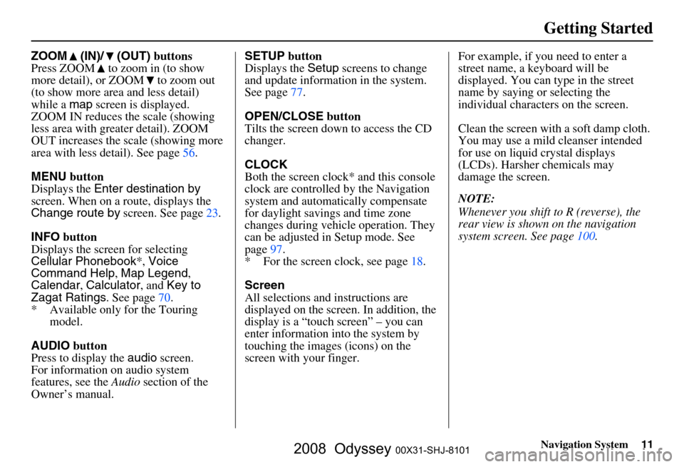
ZOOM (IN)/ (OUT) buttons
Press ZOOM to zoom in (to show
more detail), or ZOOM to zoom out
(to show more area and less detail)
while a map screen is displayed.
ZOOM IN reduces the scale (showing
less area with greater detail). ZOOM
OUT increases the scale (showing more
area with less detail). See page
56.
MENU button
Displays the Enter destination by
screen. When on a route, displays the
Change route by screen. See page
23.
INFO button
Displays the screen for selecting
Cellular Phonebook *, Voice
Command Help , Map Legend ,
Calendar , Calculator , and Key to
Zagat Ratings . See page
70 .
* Available only for the Touring model.
AUDIO button
Press to display the audio screen.
For information on audio system
features, see the Audio section of the
Owner’s manual. SETUP
button
Displays the Setup screens to change
and update informa tion in the system.
See page
77 .
OPEN/CLOSE button
Tilts the screen down to access the CD
changer.
CLOCK
Both the screen clock* and this console
clock are controlled by the Navigation
system and automatically compensate
for daylight savings and time zone
changes during vehicle operation. They
can be adjusted in Setup mode. See
page
97 .
* For the screen clock, see page
18.
Screen
All selections and instructions are
displayed on the screen. In addition, the
display is a “touch screen” – you can
enter information into the system by
touching the images (icons) on the
screen with your finger.For example, if you need to enter a
street name, a keyboard will be
displayed. You can type in the street
name by saying or selecting the
individual character
s on the screen.
Clean the screen with a soft damp cloth.
You may use a mild cleanser intended
for use on liquid crystal displays
(LCDs). Harsher chemicals may
damage the screen.
NOTE:
Whenever you shift to R (reverse), the
rear view is shown on the navigation
system screen. See page
100.
2008 Odyssey 00X31-SHJ-8101
Page 49 of 148
Navigation System49
Viewing the Routes
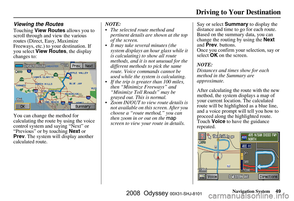
Touching View Routes allows you to
scroll through and view the various
routes (Direct, Easy, Maximize
Freeways, etc.) to your destination. If
you select View Routes , the display
changes to:
You can change the method for
calculating the route by using the voice
control system and saying “Next” or
“Previous” or by touching Next or
Prev . The system will display another
calculated route. NOTE:
The selected route method and
pertinent details are shown at the top
of the screen.
It may take several minutes (the system displays an hour glass while it
is calculating) to show all route
methods, and it is not unusual for the
different methods to pick the same
route. Voice commands cannot be
used while the system is calculating.
If the trip is greater than 100 miles, then “Minimize Freeways” and
“Minimize Toll Roads” may be
grayed out. This is normal.
Zoom IN/OUT to view route details is not available on this screen. After you
choose a “route method,” you can
then zoom in or out on the map
screen to view your route in details. Say or select
Summary to display the
distance and time to go for each route.
Based on the summary data, you can
change the routing by using the Next
and Prev . buttons.
Once you confirm your selection, say or
select OK on the screen.
NOTE:
Distances and times show for each
method in the Summary are
approximate.
After calculating the route with the new
method, the system displays a map of
your current locatio n. The calculated
route will be highlighted as a blue line,
and a voice prompt will tell you how to
proceed along the highlighted route.
Touch Voice to have the guidance
repeated.
Driving to Your Destination
2008 Odyssey 00X31-SHJ-8101
Page 50 of 148
50Navigation System
Driving to Your Destination
Viewing the Destination Map
Touching View Dest. Map displays a
map of the destination vicinity. Press the
CANCEL or NAVI BACK button to
return. You can view the destination
map anytime while on route saying
“Display destination map.”
Map Screen
When you select OK on the Calculate
route to screen, the map screen
appears, showing your highlighted route
in real time.
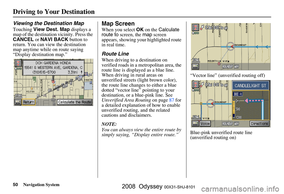
Route Line
When driving to a destination on
verified roads in a metropolitan area, the
route line is displayed as a blue line.
When driving in rural areas on
unverified streets (light brown color),
the route line changes to either a blue
dotted “vector line” pointing to your
destination, or a blue-pink line. See
Unverified Area Routing on page
87 f or
a detailed explanatio n of how to enable
unverified routing, and the related
cautions and disclaimers.
NOTE:
You can always view the entire route by
simply saying, “Display entire route.” “Vector line” (unverified routing off)
Blue-pink unverified route line
(unverified routing on)
2008 Odyssey 00X31-SHJ-8101
Page 56 of 148
56Navigation System
Driving to Your Destination
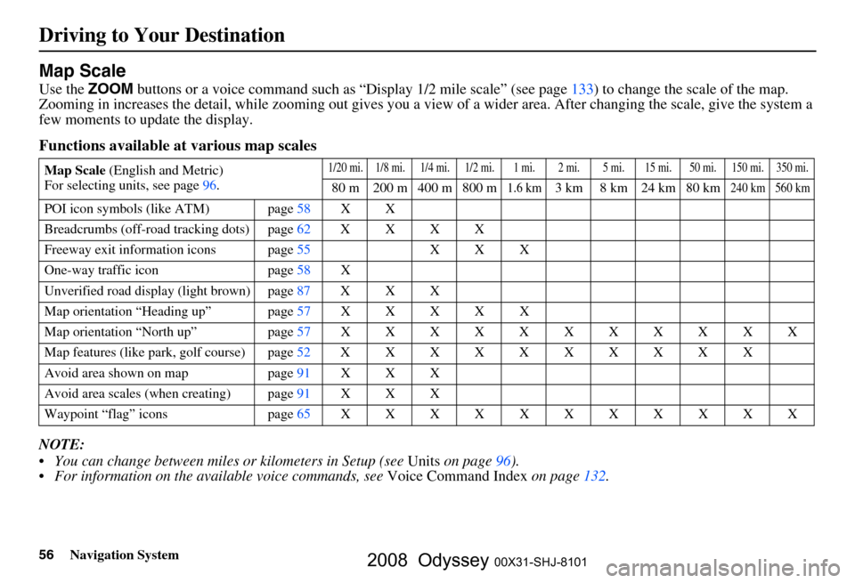
Map Scale
Use the ZOOM buttons or a voice command such as “Display 1/2 mile scale” (see page133) to change the scale of the map.
Zooming in increases the detail, while zooming out gives you a vi ew of a wider area. After changing the scale, give the system a
few moments to update the display.
Functions available at various map scales
NOTE:
You can change between miles or kilometers in Setup (see Units on page
96 ).
For information on the av ailable voice commands, see Voice Command Index on page132.
Map Scale (English and Metric)
For selecting uni ts, see page
96.1/20 mi. 1/8 mi. 1/4 mi. 1/2 mi. 1 mi. 2 mi. 5 mi. 15 mi. 50 mi. 150 mi. 350 mi.
80 m 200 m 400 m 800 m1.6 km3 km 8 km 24 km 80 km240 km 560 km
POI icon symbols (like ATM) page 58 X X
Breadcrumbs (off-road tracking dots)page62XXXX
Freeway exit information icons page
55 X X X
One-way traffic icon page
58 X
Unverified road display (light brown) page
87 X X X
Map orientation “Heading up” page57XXXXX
Map orientation “North up” page57XXXXXXXXXXX
Map features (like park, golf course)page52XXXXXXXXXX
Avoid area shown on map page
91 X X X
Avoid area scales (w hen creating) page
91 X X X
Waypoint “flag” icons page
65 XXXXXXXXXXX
2008 Odyssey 00X31-SHJ-8101
Page 123 of 148
Navigation System123
Frequently Asked Questions
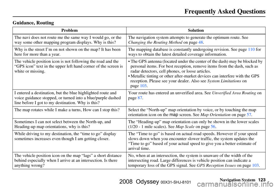
Guidance, Routing
Problem Solution
The navi does not route me the same way I would go, or the
way some other mapping progr am displays. Why is this? The navigation system attempts to
generate the optimum route. See
Changing the Routing Method on page
48.
Why is the street I’m on not s hown on the map? It has been
here for more than a year. The mapping database is
constantly undergoing revision. See page
110 for
ways to obtain the latest detailed coverage information.
The vehicle position icon is not following the road and the
“GPS icon” text in the upper left hand corner of the screen is
white or missing. The GPS antenna (located
under the center of the dash) may be blocked by
personal items. For best reception, remove items from the dash, such as
radar detectors, cell phone s, or loose articles.
Metallic tinting or other after-marke t devices can interfere with the GPS
reception. Please see your dealer. Also see System Limitations on
page
103.
I entered a destination, but th e blue highlighted route and
voice guidance stopped, or turned into a blue/purple dashed
line before I got to my destination. Why is this? Your route has entered
an unverified area. See Unverified Area Routing on
page
87.
The map rotates while I make a turns, Ho w can I stop this? Select the “North-up” ma p orientation by voice, or by touching the map
orientation icon on the map screen. See Map Orientation on page
57.
Sometimes I can not select between the North-up, and
Heading-up map orientations, why is this? The “Heading-up” map orientation can
only be shown in the lower scales
(1/20 - 1 mile scales). See Map Scale on page
56.
While driving to my destinati on, the “time to go” display
sometimes increases even though I am getting closer. The “Time to go” is based on actual
road speeds. However if your speed
slows down when you encounter slower traffic, the system updates the
“Time to go” based of your actual spee d to give you a better estimate of
arrival time.
The vehicle position icon on the map “lags” a short distance
behind especially when I arrive at an intersection. Is there
anything wrong? No, when at an intersection, the syst
em is unaware of the width of the
intersecting road. Large differences is vehicle position can indicate a
temporary loss of the GPS signal. See GPS Reception Issues on page
103.
2008 Odyssey 00X31-SHJ-8101
Page 143 of 148
Navigation System143
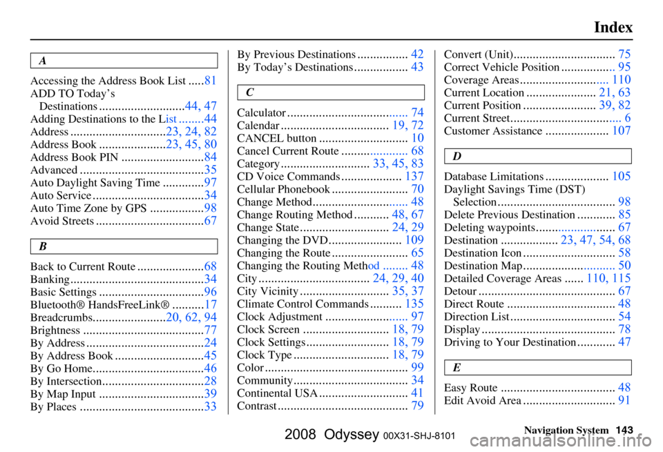
Index
A
Accessing the Address Book List
..... 81
ADD TO Today’s
Destinations
........................... 44, 47
Adding Destinations to the List........44
Address..............................23, 24, 82
Address Book.....................23, 45, 80
Address Book PIN.......................... 84
Advanced....................................... 35
Auto Daylight Saving Time.............97
Auto Service................................... 34
Auto Time Zone by GPS.................98
Avoid Streets.................................. 67
B
Back to Current Route
..................... 68
Banking.......................................... 34
Basic Settings.................................96
Bluetooth® HandsFreeLink ®..........17
Breadcrumbs.......................20, 62, 94
Brightness...................................... 77
By Address.....................................24
By Address Book............................45
By Go Home................................... 46
By Intersection................................28
By Map Input................................. 39
By Places....................................... 33
By Previous Destinations................42
By Today’s Destinations................. 43
C
Calculator
.... .................................. 74
Calendar.................................. 19, 72
CANCEL button............................10
Cancel Current Route..................... 68
Category............................33, 45, 83
CD Voice Commands...................137
Cellular Phonebook........................ 70
Change Method.............................. 48
Change Routing Method...........48, 67
Change State............................ 24, 29
Changing the DVD.......................109
Changing the Route........................ 65
Changing the Routing Meth od........ 48
City...................................24, 29, 40
City Vicinity............................35, 37
Climate Control Commands..........135
Clock Adjustment.......................... 97
Clock Screen........................... 18, 79
Clock Settings..........................18, 79
Clock Type.............................. 18, 79
Color............................................. 99
Community....................................34
Continental USA............................41
Contrast......................................... 79
Convert (Unit)................................75
Correct Vehicle Position................. 95
Coverage Areas.............. .............. 110
Current Location...................... 21, 63
Current Position....................... 39, 82
Current Street................................... 6
Customer Assistance.................... 107
D
Database Limitations
.................... 105
Daylight Savings Time (DST)
Selection
..................................... 98
Delete Previous Destination............85
Deleting waypoints.........................67
Destination.................. 23, 47, 54, 68
Destination Icon............................. 58
Destination Map............................. 50
Detailed Coverage Areas......110, 115
Detour........................................... 67
Direct Route..................................48
Direction List.................................54
Display.......................................... 78
Driving to Your Destination............47
E
Easy Route
.................................... 48
Edit Avoid Area.............................91
2008 Odyssey 00X31-SHJ-8101