High HONDA ODYSSEY 2009 RB3-RB4 / 4.G Navigation Manual
[x] Cancel search | Manufacturer: HONDA, Model Year: 2009, Model line: ODYSSEY, Model: HONDA ODYSSEY 2009 RB3-RB4 / 4.GPages: 153, PDF Size: 4.75 MB
Page 71 of 153
Navigation System71
Information Features
Calendar
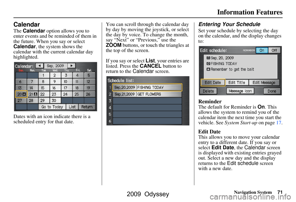
The Calendar option allows you to
enter events and be reminded of them in
the future. When you say or select
Calendar , the system shows the
calendar with the current calendar day
highlighted.
Dates with an icon indicate there is a
scheduled entry for that date. You can scroll through the calendar day
by day by moving the joystick, or select
the day by voice. To change the month,
say “Next” or “Previous,” use the
ZOOM
buttons, or touch the triangles at
the top of the screen.
If you say or select List, your entries are
listed. Press the CANCEL button to
return to the Calendar screen.
Entering Your Schedule
Set your schedule by selecting the day
on the calendar, and the display changes
to:
Reminder
The default for Reminder is On. This
allows the system to remind you of the
calendar item the next time you start the
vehicle. See System Start-up on page17.
Edit Date
This allows you to move your calendar
entry to a different date. If you say or
select Edit Date , the Calendar screen
is displayed with existing entries grayed
out. Select a new day and the display
returns to the Edit schedule screen
with a new date.
2009 Odyssey
Page 86 of 153
86Navigation System
System Setup
Unverified Area Routing
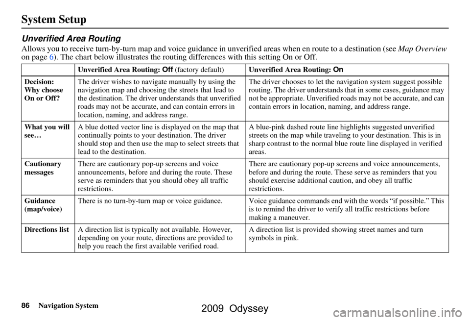
Allows you to receive turn-by-turn map and voice guidance in unverified areas when en route to a destination (see Map Overview
on page6). The chart below illustrates the rou ting differences with this setting On or Off.
Unverified Area Routing: Off (factory default) Unverified Area Routing: On
Decision:
Why choose
On or Off? The driver wishes to navi
gate manually by using the
navigation map and choosing the streets that lead to
the destination. The driver understands that unverified
roads may not be a ccurate, and can contain errors in
location, naming, and address range. The driver chooses to let the na
vigation system suggest possible
routing. The driver understands that in some cases, guidance may
not be appropriate. Unverified ro ads may not be accurate, and can
contain errors in location, naming, and address range.
What you will
see… A blue dotted vector line is displayed on the map that
continually points to your
destination. The driver
should stop and then use the ma p to select streets that
lead to the destination. A blue-pink dashed route line
highlights suggested unverified
streets on the map while traveling to your destination. This is in
sharp contrast to the normal blue route line displayed in verified
areas.
Cautionary
messages There are cautionary pop-up screens and voice
announcements, before and
during the route. These
serve as reminders that you should obey all traffic
restrictions. There are cautionary pop-up sc
reens and voice announcements,
before and during the route. These serve as reminders that you
should exercise additional ca ution, and obey all traffic
restrictions.
Guidance
(map/voice) There is no turn-by-turn map or voice guidance. Voice gui
dance commands end with the words “if possible.” This
is to remind the driver to verify all traffic restrictions before
making a maneuver.
Directions list A direction list is typicall y not available. However,
depending on your route, dire ctions are provided to
help you reach the first available verified road. A direction list is provided showing street names and turn
symbols in pink.
2009 Odyssey
Page 91 of 153
Navigation System91
System Setup
NOTE:
The maximum size of the “Avoid area”
is 1/4 of the navigation display screen
regardless of the map scale setting.
The selected area will be displayed as a
shaded box with a yellow border. Push
in on the joystick to set the end point of
the avoided area. To “redraw” the area,
touch Cancel and repeat the area
selection process. If your selected area
contains a freeway, the system will
prompt you with a pop-up box saying
“Do you want to avoid freeways?” Answering “No” allows you to enter a
route through an avoided area on a
freeway and skip the “Avoid area
caution box.” See
Pop-Ups and
Disclaimers on page64.
Say or select Done to return to the Edit
area screen. When you return, the
“Vicinity” field is automatically filled in
by the system. Re-edit the area “Name”
if desired. Select Done on the Edit
avoid area screen to finish editing.
Your new avoided area will now appear
on the “Avoid area” list screen and be
viewable on the map screen. NOTE:
You can select areas to avoid,
however you cannot select roads or
areas that you want the system to use
for routing.
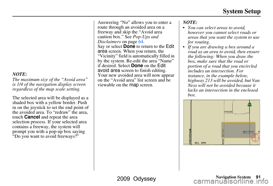
If you are drawing a box around a road as an area to avoid, then ensure
the following: When you draw the
box, make sure that the road or
portion of a road that you encircled
includes an intersection. For
instance, in the example below,
highway 213 will be avoided, but Van
Ness will not be avoided because it
lacks an intersectio n in the enclosed
box.
2009 Odyssey
Page 92 of 153
92Navigation System
System Setup
Edit Waypoint Search Area
When driving en route to your
destination, you can select a temporary
destination waypoint (marked with a
small flag on the map) along your route
for gas, a restaurant, or other POI. When
you resume your trip from the waypoint,
the system continues the trip to your
original destination. To use this feature,
see Waypoints on page65.
This Setup item allows you to select the
distance from your highlighted route
line (on either side of your route) that
the system will search for a waypoint.
From the Routing & Guidance screen,
select Edit for “Edit Waypoint Search
Area,” and then choose the desired
search distance for either “On
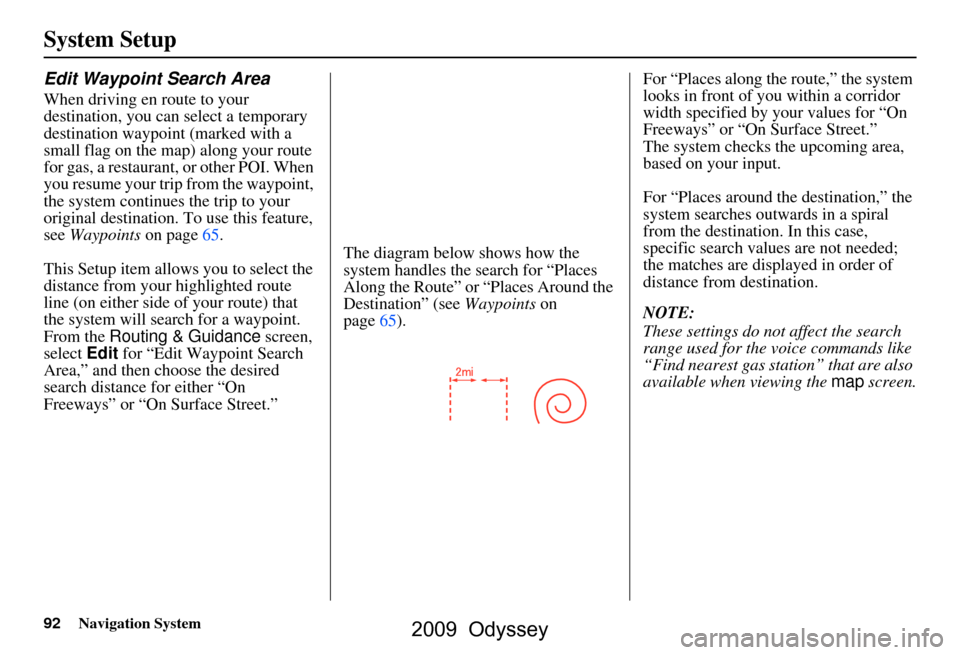
Freeways” or “On Surface Street.” The diagram below shows how the
system handles the search for “Places
Along the Route” or
“Places Around the
Destination” (see Waypoints on
page65). For “Places along the route,” the system
looks in front of you within a corridor
width specified by your values for “On
Freeways” or “On Surface Street.”
The system checks the upcoming area,
based on your input.
For “Places around the destination,” the
system searches outwards in a spiral
from the destination. In this case,
specific search values are not needed;
the matches are displayed in order of
distance from destination.
NOTE:
These settings do not affect the search
range used for the voice commands like
“Find nearest gas station” that are also
available when viewing the
map screen.
2009 Odyssey
Page 102 of 153
102Navigation System
System Limitations
Although your navigation system is one
of the most highly sophisticated pieces
of equipment you will find in a modern
automobile, you may find during its use
that it has certain limitations.
The system uses GPS signals to aid in
determining its current location. The
GPS is operated by the U.S.
Department of Defense. For security
reasons, there are certain inaccuracies
built into the GPS that the navigation
system must constantly compensate for.
This can cause occasional positioning
errors of up to several hundred feet.
For example, in urban areas where
streets are close together, this could
cause the system to show that you are
traveling on a street that parallels the
street you are actually on. The system
will, under most circumstances, correct
itself while you drive. Depending on your current view of the
sky and the position of the satellites, the
elevation may be shown incorrectly.
You may also notice some delay of the
vehicle position icon at intersections;
this is normal.
GPS Reception Issues
The signals received from the GPS
satellites are extremely weak (less than
a millionth of the strength of a local FM
station) and requir
e an unobstructed
view of the sky. The signal can easily be
interrupted or interfered with by the
following:
Aftermarket metallic window tint above or to the sides of the GPS
antenna (located under the
dashboard)
Cell phones, PDAs, or other electronic devices docked in a cradle
or lying loose on the dashboard
Radar detectors mounted on the dashboard
Remote starters, or “hidden” vehicle tracking systems mounted near the
navigation unit Other aftermarket audio electronic
devices mounted near the navigation
unit
Trees, tall buildings, freeway overpasses, tunnels, or overhead
electrical power wires
Although the system will direct you to
your desired destination, it may not
always generate what you consider to be
the most direct rout e. Try changing the
method of routing. See Changing the
Routing Method on page48. You may
also have Unverified Area Routing set
to OFF. See Unverified Area Routing on
page86.
Additionally, the mapping database
contains verified and unverified maps.
See Map Overview on page6. A
Disclaimer screen will warn you if your
route includes unverified streets.
Unverified streets may be missing from
the map, in the wrong location, or have
an incorrect name or address range.
Exercise addition al caution when
driving in these unverified areas.
2009 Odyssey
Page 115 of 153
Navigation System115
Coverage Areas
Fraser Valley
Abbottsford
Chilliwack
Mission
Squamish-Lillooet Squamish
Whistler
Thompson-Nicola Kamloops
Central Okanagan Kelowna
Peachland
Okanagan-Similkamen Penticton
Summerland
Victoria
CapitalCentral Saanich
Colwood
Esquimalt
Highlands
Langford
Metchosin
North Saanich
Oak Bay
Saanich
Sidney Sooke
Victoria
View Royal
MANITOBA
East St Paul
Headingley
West St Paul
Winnipeg
NOVA SCOTIA
Halifax
(partial)
ONTARIO
Brant
Brant
Brantford
Chatham-Kent Chatham-Kent
Dufferin Amaranth
East Garafraxa
East Luther Grand Valley
Melancthon
Mono
Mulmur
Orangeville
Shelburne Durham
Ajax
Brock
Clarington
Oshawa
Pickering
Scugog
Uxbridge
Whitby
Elgin Aylmer
Bayham
Central Elgin
Dutton/Dunwich
Malahide
Southwold
St. Thomas
West Elgin
Frontenac Frontenac Islands
Kingston
Gatineau Gatineau
2009 Odyssey
Page 116 of 153
116Navigation System
Coverage Areas
GreyBlue Mountains
Chatsworth
Georgian Bluffs
Meaford
Grey Highlands
Hanover
Owen Sound
Southgate
West Grey
Haldimand Haldimand
Halton Burlington
Halton Mills
Milton
Oakville
Hamilton Hamilton
Kawartha Lakes Kawartha Lakes
Lambton Brooke-Alvinston
Dawn-Euphemia
Enniskillen
Lambton Shores
Oil Springs Petrolia
Plympton-Wyoming
Point Edward
Sarnia
St Clair
Warwick
Muskoka Bracebridge
Georgian Bay
Gravenhurst
Huntsville
Lake of Bays
Muskoka Lakes
Middlesex Adelaide Metcalfe
London
Lucan Biddulph
Middlesex Centre
Newbury
North Middlesex
Southwest Middlesex
Strathroy-Caradoc
Thames Centre
Niagara Fort Erie
Grimsby
Lincoln
Niagara-on-the-Lake
Niagara Falls Pelham
Port Colborne
St Catharines
Thorold
Wainfleet
Welland
West Lincoln
Norfolk Norfolk
Ottawa Ottawa
Oxford Blandford-Blenheim
East Zorra-Tavistock
Ingersoll
Norwich
South-West Oxford
Tillsonburg
Woodstock
Zorra
Peel Brampton
Caledon
Mississauga
2009 Odyssey
Page 126 of 153
126Navigation System
Frequently Asked Questions
Guidance, Routing
ProblemSolution
The navigation does not route me the same way I would go, or
the way some other mapping program displays. Why is this? The navigation system attempts to
generate the optimum route. See
Changing the Routing Method on page48.
Why is the street I’m on not shown on the map? It has been
here for more than a year. The mapping database is
constantly undergoing revision. See page107 for
ways to obtain the latest de tailed coverage information.
The vehicle position icon is not following the road, and the
“GPS icon” text in the upper left hand corner of the screen is
white or missing. The GPS antenna (located under the center of the dashboard) may be
blocked by personal items. For best reception, remove items from the
dashboard, such as radar detector s, cell phones, or loose articles.
Metallic tinting or other aftermarke t devices can interfere with the GPS
reception. Please see your dealer. Also see System Limitations on
page102.
I entered a destination, but th e blue highlighted route and
voice guidance stopped, or turned into a blue/pink dashed line
before I got to my dest ination. Why is this? Your route has entered
an unverified area. See Unverified Area Routing on
page86.
The map rotates while I make turns. How can I stop this? Select the North-up map orientation by voice, or by touching the map
orientation icon on the map screen. See Map Orientation on page57.
Sometimes, I cannot select between the North-up and
Heading-up map orienta tions. Why is this? The Heading-up map orient
ation can only be shown in the lower scales
(1/20 - 1 mile scales). See Map Scale on page56.
While driving to my destinati on, the “time to go” display
sometimes increases, even though I am getting closer. The “Time to go” is based on actual
road speeds. However if your speed
slows down when you encounter slower traffic, the system updates the
“Time to go” based on your actual spee d to give you a better estimate of
arrival time.
The vehicle position icon on the map “lags” a short distance
behind, especially when I arrive at an intersection. Is there
anything wrong? No. When at an intersection, the syst
em is unaware of the width of the
intersecting road. Large differences in vehicle position can indicate a
temporary loss of the GPS signal. See GPS Reception Issues on page102.
2009 Odyssey
Page 131 of 153
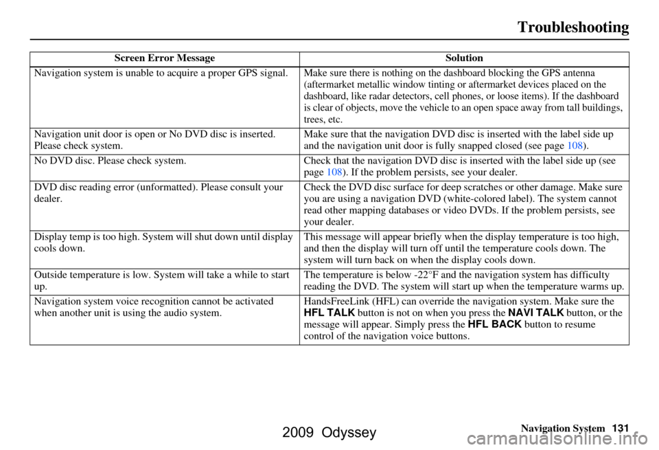
Navigation System131
Troubleshooting
Screen Error Message Solution
Navigation system is unable to acquire a proper GPS signal.
Make sure there is nothing on the dashboard blocking the GPS antenna
(aftermarket metallic window tinting or aftermarket devices placed on the
dashboard, like radar detectors, cell p hones, or loose items). If the dashboard
is clear of objects, move the vehicle to an open space away from tall buildings,
trees, etc.
Navigation unit door is open or No DVD disc is inserted.
Please check system. Make sure that the navigation DVD disc
is inserted with the label side up
and the navigation unit door is fully snapped closed (see page108).
No DVD disc. Please check system. Check that the navigation DVD disc is in serted with the label side up (see
page108). If the problem persists, see your dealer.
DVD disc reading error (unfor matted). Please consult your
dealer. Check the DVD disc surface
for deep scratches or other damage. Make sure
you are using a navigation DVD (white-c olored label). The system cannot
read other mapping databases or vide o DVDs. If the problem persists, see
your dealer.
Display temp is too high. Syst em will shut down until display
cools down. This message will appear briefly when
the display temperature is too high,
and then the display will turn off until the temperature cools down. The
system will turn back on when the display cools down.
Outside temperature is low. System will take a while to start
up. The temperature is below -22°F and
the navigation system has difficulty
reading the DVD. The system will st art up when the temperature warms up.
Navigation system voice recognition ca nnot be activated
when another unit is us ing the audio system. HandsFreeLink (HFL) can override the
navigation system. Make sure the
HFL TALK button is not on when you press the NAVI TALK button, or the
message will appear. Simply press the HFL BACK button to resume
control of the navigation voice buttons.
2009 Odyssey
Page 138 of 153
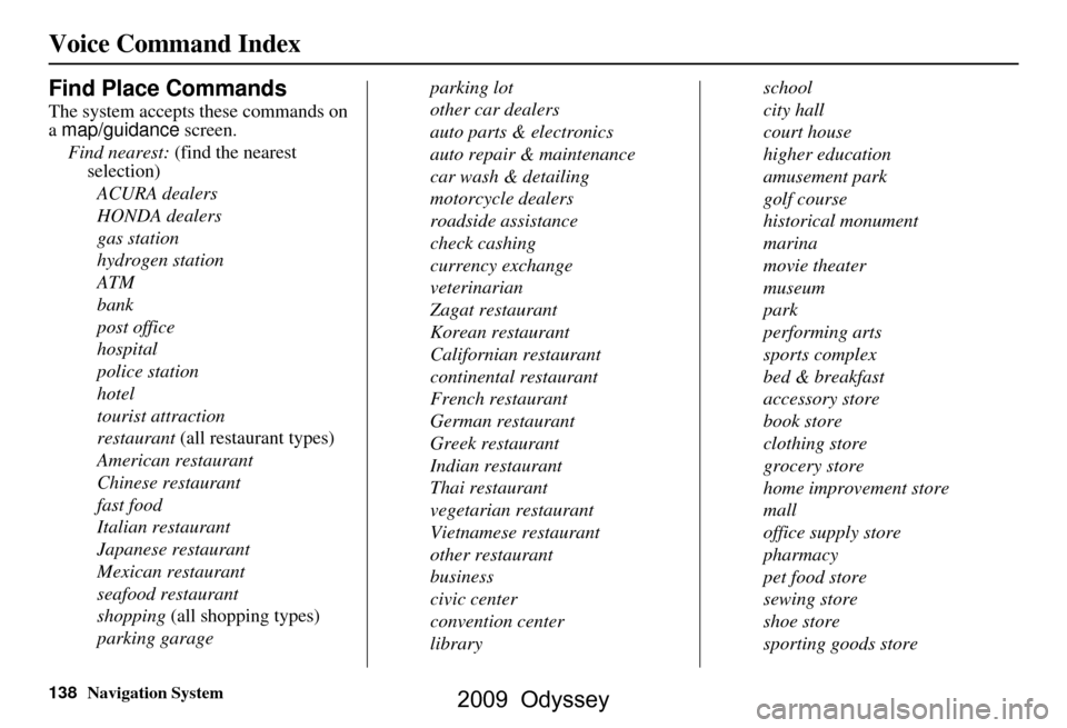
138Navigation System
Voice Command Index
Find Place Commands
The system accepts these commands on
a map/guidance screen.
Find nearest: (find the nearest
selection)
ACURA dealers
HONDA dealers
gas station
hydrogen station
ATM
bank
post office
hospital
police station
hotel
tourist attraction
restaurant (all restaurant types)
American restaurant
Chinese restaurant
fast food
Italian restaurant
Japanese restaurant
Mexican restaurant
seafood restaurant
shopping (all shopping types)
parking garage parking lot
other car dealers
auto parts & electronics
auto repair & maintenance
car wash & detailing
motorcycle dealers
roadside assistance
check cashing
currency exchange
veterinarian
Zagat restaurant
Korean restaurant
Californian restaurant
continental restaurant
French restaurant
German restaurant
Greek restaurant
Indian restaurant
Thai restaurant
vegetarian restaurant
Vietnamese restaurant
other restaurant
business
civic center
convention center
libraryschool
city hall
court house
higher education
amusement park
golf course
historical monument
marina
movie theater
museum
park
performing arts
sports complex
bed & breakfast
accessory store
book store
clothing store
grocery store
home improvement store
mall
office supply store
pharmacy
pet food store
sewing store
shoe store
sporting goods store
2009 Odyssey