ad blue HONDA ODYSSEY 2011 RB3-RB4 / 4.G Navigation Manual
[x] Cancel search | Manufacturer: HONDA, Model Year: 2011, Model line: ODYSSEY, Model: HONDA ODYSSEY 2011 RB3-RB4 / 4.GPages: 178, PDF Size: 3.97 MB
Page 56 of 178
56Navigation System
Driving to Your Destination
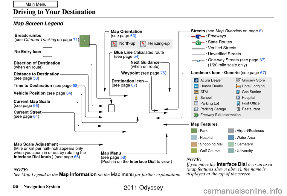
Map Screen Legend
Direction of Destination
(when en route)
Vehicle Position (see page64)
Current Map Scale
(see page 66)
Current Street
(see page 64)
Map Scale Adjustment
(Mile or km per half-inch appears only
when you zoom in or out by rotating the
Interface Dial knob .) (see page66)
NOTE:
See Map Legend in the Map Information on the Map menu for further explanation.
Waypoint (see page75)
Map Orientation
(see page
63)
Breadcrumbs
(see
Off-road Tracking on page71)
NOTE:
If you move the Interface Dial over an area
(map features shown above), the name is
displayed at the top of the screen.
Blue Line Calculated route
(see page 54)
Distance to Destination
(see page 58)
Time to Destination (see page58) Destination Icon
(see page
67)
Next Guidance
(when en route)
: Par k
: Hospital
: Shopping Mall
: Golf Course
: Airport/Business
: Water Area
: Cemetery
: University
Streets (see
Map Overview on page6)
: Freeways
: State Routes
: Verified Streets
: Unverified Streets
: One-way Streets (see page 67)
(1/20 mile scale only)
Landmark Icon - Generic (see page67)
Grocery Store
Hotel/Lodging
Gas Station
Hospital
Post Office
Restaurant
Acura Dealer
Honda Dealer
AT M
School
Parking Lot
Parking Garage
Freeway Exit Information
No Entry Icon
Map Menu
(see page
58)
(Push in on the Interface Dial to view.)
North-up
Heading-up
Map Features
2011 Odyssey
Page 62 of 178
62Navigation System
Driving to Your Destination
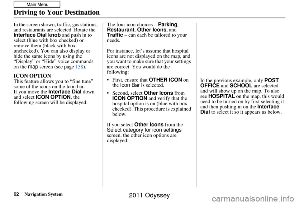
In the screen shown, traffic, gas stations,
and restaurants are selected. Rotate the
Interface Dial knob and push in to
select (blue with box checked) or
remove them (black with box
unchecked). You can also display or
hide the same icons by using the
“Display” or “Hide” voice commands
on the map screen (see page 158).
ICON OPTION
This feature allows you to “fine tune”
some of the icons on the Icon bar.
If you move the Interface Dial down
and select ICON OPTION , the
following screen will be displayed: The four icon choices – Parking
,
Restaurant , Other Icons , and
Traffic – can each be tailored to your
needs.
For instance, let’s assume that hospital
icons are not displayed on the map, and
you want to make sure that your settings
are correct. You would do the
following:
• First, ensure that OTHER ICON on
the Icon Bar is selected.
• Second, select Other Icons from
ICON OPTION and verify that the
hospital option is on (blue with box
checked). This procedure is explained
below.
If you select Other Icons from the
Select category for icon settings
screen, the other icon options are
displayed: In the previous example, only
POST
OFFICE and SCHOOL are selected
and will show up on the map. To also
see HOSPITAL on the map, this would
need to be turned on by first selecting it
and then pushing in on the Interface
Dial to select it so it appears as below.
2011 Odyssey
Page 88 of 178
88Navigation System
Phone Features
The PHONE option allows you to pair a
Bluetooth-compatible cell phone to the
Bluetooth ® HandsFreeLink® system.
You can make and receive calls, store
speed dial entries, and import your
cellular phonebook (on some phones).
Up to six phones can be paired to the
system.
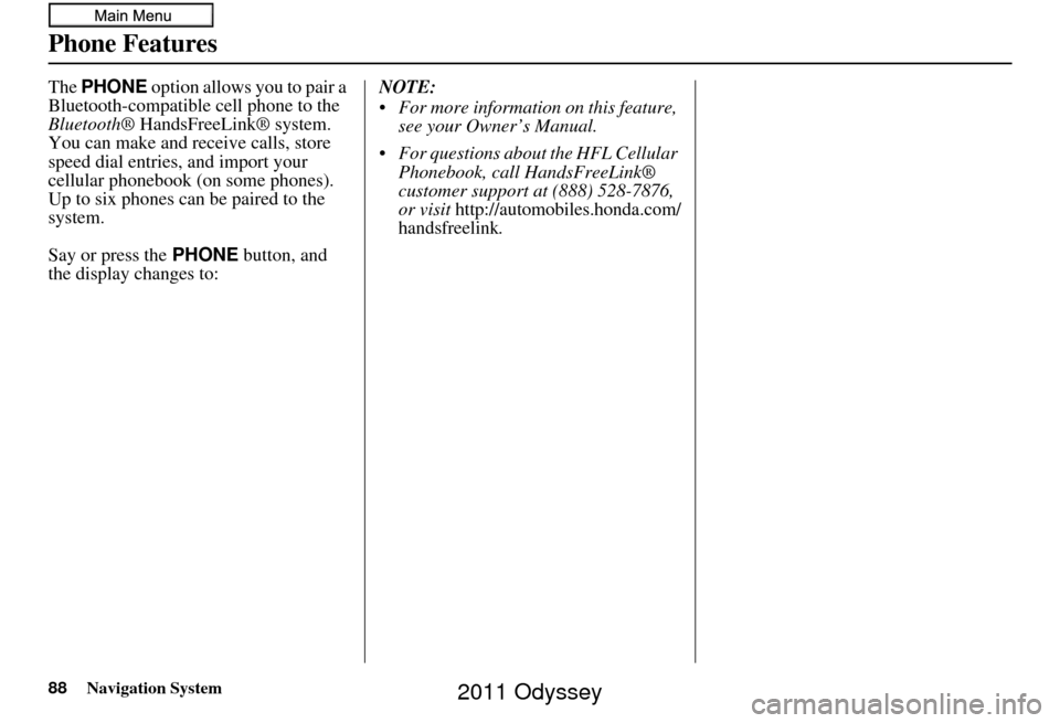
Say or press the PHONE button, and
the display changes to: NOTE:
For more information on this feature,
see your Owner’s Manual.
For questions about the HFL Cellular Phonebook, call HandsFreeLink®
customer support at (888) 528-7876,
or visit
http://automobiles.honda.com/
handsfreelink.
2011 Odyssey
Page 101 of 178
Navigation System101
System Setup
Unverified Area Routing
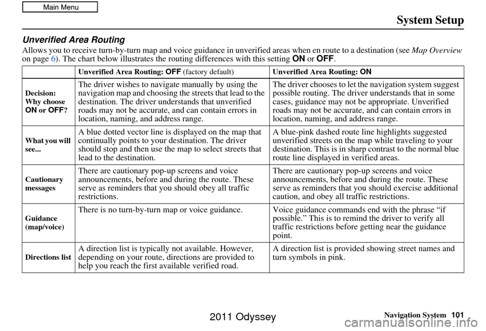
Allows you to receive turn-by-turn ma p and voice guidance in unverified areas when en route to a destination (see Map Overview
on page 6). The chart below illustrates the routing differences with this setting ON or OFF .
Unverified Area Routing: OFF (factory default) Unverified Area Routing: ON
Decision:
Why choose
ON or OFF ?
The driver wishes to navigate manually by using the
navigation map and choosing th e streets that lead to the
destination. The driver un derstands that unverified
roads may not be accurate, and can contain errors in
location, naming, and address range. The driver chooses to let th
e navigation system suggest
possible routing. The driver understands that in some
cases, guidance may not be appropriate. Unverified
roads may not be accurate, and can contain errors in
location, naming, and address range.
What you will
see...A blue dotted vector line is displayed on the map that
continually points to your destination. The driver
should stop and then use the map to select streets that
lead to the destination. A blue-pink dashed route line highlights suggested
unverified streets
on the map while traveling to your
destination. This is in sharp contrast to the normal blue
route line displayed in verified areas.
Cautionary
messagesThere are cautionary pop-up screens and voice
announcements, before and during the route. These
serve as reminders that you should obey all traffic
restrictions. There are cautionary pop-
up screens and voice
announcements, before and during the route. These
serve as reminders that you should exercise additional
caution, and obey all traffic restrictions.
Guidance
(map/voice)There is no turn-by-turn map or voice guidance. Voice guidance co mmands end with the phrase “if
possible.” This is to remind the driver to verify all
traffic restrictions before getting near the guidance
point.
Directions listA direction list is typically not available. However,
depending on your route, directions are provided to
help you reach the first available verified road. A direction list is provided showing street names and
turn symbols in pink.
2011 Odyssey
Page 103 of 178
Navigation System103
System Setup
With Unverified Area Routing OFF ,
before you enter an unverified street, a
caution box appears on the screen and a
voice message is given. This lets you
know that you are about to enter an
unverified area and that you will be
following a dotted “vector line” that
points to your destination.
With Unverified Area Routing ON,
a caution box appear s on the screen and
is read by the voice. In this case, you
will be presented with a dashed blue/
pink line instead of the regular blue
route line. This is your signal to pay
attention to posted traffic restrictions.
You cannot assume that all guidance is
appropriate.
In both cases, when you actually enter
the unverified street, a short caution will
remind you. You will see and hear this
short caution message whenever you
enter unverified areas.
If you regularly enter and leave
unverified roads for short amounts of
time, there may be cases where no
guidance is provided. Unverified Area Routing “OFF” Unverified Area Routing “ON”
2011 Odyssey
Page 104 of 178
104Navigation System
System Setup
With Unverified Area Routing OFF ,
you are presented with a blue “vector
line” that always points to the
destination. You must manually choose
streets from the map that will lead to
your destination. No guidance is
provided, and there are no directions to
the destination.
With Unverified Area Routing ON,
a blue/pink route line is shown for
unverified segments. Voice guidance
commands in unverified areas always
end with “if possible.” This is your
signal that you should use additional
caution, and obey all traffic restrictions.
The guidance window “arrow” shows
any portions of unverified turns in blue/
pink dashes.
These guidances are only a suggestion.
You should always confirm that the
guidance is possible.
A directions list is also provided that
shows any unverified roads in a blue
color, with pink arrows pointing to the
next guidance point. Unverified Area Routing “OFF”
NOTE:
For the pop-up menu displayed when
pushing in on the
Interface Dial from
the map screen, Voice is grayed out.
With Unverified Area Routing OFF , no
Direction List is provided. Unverified Area
Routing “ON”
2011 Odyssey
Page 136 of 178
136Navigation System
Coverage Areas
DurhamAjax
Brock
Clarington
Oshawa
Pickering
Scugog
Uxbridge
Whitby
Elgin Aylmer
Bayham
Central Elgin
Dutton/Dunwich
Malahide
Southwold
St. Thomas
West Elgin
Frontenanc Central Frontenac
Frontenac Islands
Kingston
North Frontenac
South Frontenac
Gatineau Gatineau Grey
Blue Mountains
Chatsworth
Georgian Bluffs
Meaford
Grey Highlands
Hanover
Owen Sound
Southgate
West Grey
Haldimand Haldimand
Halton Burlington
Halton Mills
Milton
Oakville
Hamilton Hamilton
Kawartha Lakes Kawartha Lakes
Lambton Brooke-Alvinston
Dawn-Euphemia
Enniskillen
Lambton Shores
Oil Springs Petrolia
Plympton-Wyoming
Point Edward
Sarnia
St. Clair
Warwick
Lanark Beckwith
Carleton Place
Drummond/North Elmsley
Lanark Highlands
Mississippi Mills
Montague
Perth
Smiths Falls
Tay Valley
Leeds and Grenville Athens
Augusta
Brockville
Edwardsburgh/Cardinal
Elizabethtown-Kitley
Front of Yonge
Gananoque
Leeds and the Thousand Islands
Merrickville-Wolford
North Grenville
Prescott
Rideau Lakes
Westport
2011 Odyssey
Page 148 of 178
148Navigation System
Frequently Asked Questions
Guidance, Routing
ProblemSolution
The navigation system does not route me the same way I
would go, or the way some ot her mapping program displays.
Why is this? The navigation system attempts to
generate the optimum route. See
Changing the Route Preference on page53.
Why is the street I’m on not shown on the map? It has been
here for more than a year. The mapping database is
constantly undergoing revision. See page128 for
ways to obtain the latest de tailed coverage information.
The vehicle position icon is not following the road and the
“GPS icon” text in the upper left hand corner of the screen is
white or missing. • The GPS antenna (located in the
dashboard) may be blocked by personal
items. For best reception, remove items from the dashboard, such as radar
detectors, cell phones, or loose articles.
• Metallic tinting or othe r aftermarket devices can interfere with the GPS
reception. Please see your dealer. Also see System Limitations on
page 123.
I entered a destination, but th e blue highlighted route and
voice guidance stopped, or turned into a blue/pink dashed line
before I got to my dest ination. Why is this? Your route has entered
an unverified area. See Unverified Area Routing on
page 101.
The map rotates while I make turns. How can I stop this? Select the North-up map orientati on by voice, or by selecting North-up
from the Map menu . See Map Orientation on page 63.
Sometimes, I cannot select between the North-up and
Heading-up map orienta tions. Why is this? The Heading-up map orientat
ion can only be shown in the lower scales
Map Scale on page66.
While driving to my destinati on, the “time to go” display
sometimes increases, even though I am getting closer. The “Time to go” is based on actual
road speeds. However if your speed
slows down when you encounter slower traffic, the system updates the
“Time to go” based on your actual spee d to give you a better estimate of
arrival time.
The vehicle position icon on the map “lags” a short distance
behind, especially when I arrive at an intersection. Is there
anything wrong? No. When at an intersection, the syst
em is unaware of the width of the
intersecting road. Large differences in vehicle position can indicate a
temporary loss of the GPS signal. See GPS Reception Issues on page123.
(1/20 - 1 mile scales). See
2011 Odyssey
Page 154 of 178
154Navigation System
Glossary
Glossary
The following is a glossary of terms
pertaining to the voice recognition
navigation system.
Avoid Area - Areas you wish to avoid
can be entered into the system, and
will be avoided while routing.
Breadcrumbs - Off-road tracking dots
that can be followe d on the map to
retrace your route back to a mapped
(digitized) road. This function can be
turned on/off in the SETUP screen
(Other ).
Database - This consists of the map
data, and the POI (Points of Interest)
data stored on the HDD.
DCA - Detailed Coverage Area. United
States, Canada, and Puerto Rico are
mapped. See page 128 for a list of
these areas. Digitized Road -
A road that appears on
the navigation screen. The road name
will appear at the bottom of the
navigation screen. If the user drives
“off road,” the navigation system will
display “breadcrumbs,” depending on
how far you drive from a mapped
road.
Disclaimer Screen - Screen containing
cautionary information. It is meant to
be read carefully and acknowledged
by the client when using the
navigation system.
FAQ - Frequently Asked Questions. See
page 146 for a list of the client FAQs
and troubleshootin g information.
GPS - Global Positioning System. A
network of 24 satellites in orbit
around the earth. The navigation
system can simultaneously receive
signals from up to 12 satellites to
accurately position the vehicle on the
map. GPS Antenna -
Located in the
dashboard, which is in the center of
the dashboard. Electronic items
operating in this general location can
interfere with the GPS signal.
HDD - Hard Disc Drive. The primary
data storage device containing your
vehicle’s navigation and map
software and uploaded wallpaper
images. The HDD can also store
audio files. See the Audio section of
your Owner’s Manual for more
information.
HFL - Bluetooth ® HandsFreeLink®.
Your vehicle is equipped with this
feature, which uses Bluetooth
technology as a wireless link between
the vehicle and your Bluetooth-
compatible cell phone.
Icon - Symbol representing Points of
Interest (POI) that can be displayed
on the map.
2011 Odyssey
Page 164 of 178
164Navigation System
Voice Command Index
Bluetooth® Audio Commands
The system accepts these commands on
most screens.BTA Bluetooth Audio play
BTA Bluetooth Audio skip forward
BTA Bluetooth Audio skip back
BTA Bluetooth Audio group up
BTA Bluetooth Audio group down
BTA Bluetooth Audio pause
BTA Bluetooth Audio resume
NOTE:
Bluetooth® audio commands may not
work on some phones or Bluetooth®
audio devices.
AUX Commands
The system accepts these commands on
most screens. AUX play (or Auxiliary play )
Song By Voice™ Commands
The system accepts these commands on
most screens.
iPod Search (activates Song By
Voice™)
HDD Search (activates Song By Voice™)
List Album (specify album)
List Artist (specify artist)
List Composer (specify composer)
List Genre (specify genre)
List Playlist (specify playlist)
Play Album (specify album)
Play Artist (specify artist)
Play Composer (specify composer)
Play Genre (specify genre)
Play Playlist (specify playlist)
Play Song (specify song)
What/Who am I listening to?
Who is this?
What’s playing?
Who’s playing?
What album is this?
NOTE:
Song By Voice™ commands are
available for tracks stored in the HDD
or iPod.
Rear Radio Commands
The system accepts these commands on
most screens. Rear audio on*
Rear audio off*
Rear radio on*
Rear radio off*
Rear radio select FM1
Rear radio select FM2
Rear radio select AM
Rear radio tune to # FM (#: frequency. Example Radio 95.5
FM)
Rear radio tune to # AM (#: frequency. Example Radio
1020 AM)
Rear radio seek up
Rear radio seek down
Rear radio next station
Rear radio preset # (#: 1-6)
Rear radio FM preset # (#: 1-6)
Rear radio FM1 preset # (#: 1-6)
Rear radio FM2 preset # (#: 1-6)
Rear radio AM preset # (#: 1-6)
* Repeating these commands switches (toggles) the function between On
and Off, so the action that occurs
may not match the command you
speak.
2011 Odyssey