Acc HONDA ODYSSEY 2016 RC1-RC2 / 5.G Navigation Manual
[x] Cancel search | Manufacturer: HONDA, Model Year: 2016, Model line: ODYSSEY, Model: HONDA ODYSSEY 2016 RC1-RC2 / 5.GPages: 325, PDF Size: 8.63 MB
Page 280 of 325
279
TroubleshootingGuidance, Routing
Troubleshooting
Guidance, Routing
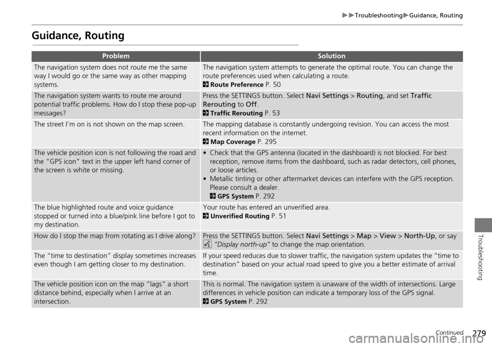
ProblemSolution
The navigation system does not route me the same
way I would go or the same way as other mapping
systems.The navigation system attempts to generate the optimal route. You can change the
route preferences used when calculating a route.
2Route Preference P. 50
The navigation system wants to route me around
potential traffic problems. How do I stop these pop-up
messages?Press the SETTINGS button. Select Navi Settings > Routing , and set Traffic
Rerouting to Off .
2Traffic Rerouting P. 53
The street I’m on is not shown on the map screen.The mapping database is constantly undergoing revision. You can access the most
recent information on the internet.
2Map Coverage P. 295
The vehicle position icon is not following the road and
the “GPS icon” text in th e upper left hand corner of
the screen is white or missing.• Check that the GPS antenna (located in the dashboard) is not blocked. For best reception, remove items from the dashboard, such as radar detectors, cell phones,
or loose articles.
• Metallic tinting or other aftermarket devi ces can interfere with the GPS reception.
Please consult a dealer.
2 GPS System P. 292
The blue highlighted route and voice guidance
stopped or turned into a blue/pink line before I got to
my destination.Your route has entered an unverified area.
2Unverified Routing P. 51
How do I stop the map from rotating as I drive along?Press the SETTINGS button. Select Navi Settings > Map > View > North-Up , or say
d “Display north-up” to change the map orientation.
The “time to destination” display sometimes increases
even though I am getting closer to my destination.If your speed reduces due to slower traffic, the navigation system updates the “time to
destination” based on your actual road speed to give you a better estimate of arrival
time.
The vehicle position icon on the map “lags” a short
distance behind, especially when I arrive at an
intersection.This is normal. The navigation system is un aware of the width of intersections. Large
differences in vehicle position can indicate a temporary loss of the GPS signal.
2 GPS System P. 292
Continued
Page 282 of 325
281
TroubleshootingUpdate, Coverage, Map Errors
Troubleshooting
Update, Coverage, Map Errors
Display, Accessories
Miscellaneous Questions
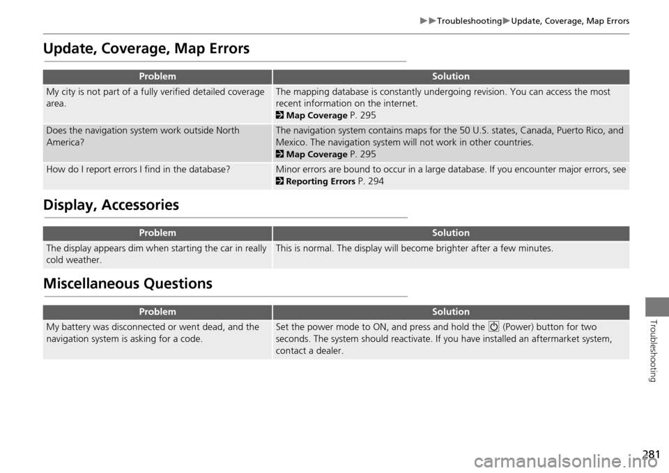
ProblemSolution
My city is not part of a fully verified detailed coverage
area.The mapping database is constantly undergoing revision. You can access the most
recent information on the internet.
2 Map Coverage P. 295
Does the navigation system work outside North
America?The navigation system contains maps for the 50 U.S. states, Canada, Puerto Rico, and
Mexico. The navigation system will not work in other countries.
2Map Coverage P. 295
How do I report errors I find in the database?Minor errors are bound to occur in a large database. If you encounter major errors, see
2Reporting Errors P. 294
ProblemSolution
The display appears dim when starting the car in really
cold weather.This is normal. The display will become brighter after a few minutes.
ProblemSolution
My battery was disconnected or went dead, and the
navigation system is asking for a code.Set the power mode to ON, and press and hold the 9 (Power) button for two
seconds. The system should reactivate. If you have installed an aftermarket system,
contact a dealer.
Page 283 of 325
282
Troubleshooting
Error Messages
Navigation System
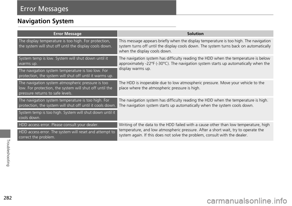
Error MessageSolution
The display temperature is too high. For protection,
the system will shut off until the display cools down.This message appears briefly when the display temperature is too high. The navigation
system turns off until the display cools down. The system turns back on automatically
when the display cools down.
System temp is low. System will shut down until it
warms up.The navigation system has difficulty readi ng the HDD when the temperature is below
approximately -22°F (-30°C). The navigation system starts up automatically when the
display warms up.
The navigation system temperature is too low. For
protection, the system will shut off until it warms up.
The navigation system atmospheric pressure is too
low. For protection, the syst em will shut off until the
pressure returns to safe levels.The HDD is inoperable due to low atmospheric pressure. Move your vehicle to the
place where the atmospheric pressure is high.
The navigation system temperature is too high. For
protection, the system will shut off until it cools down.The navigation system has difficulty reading the HDD when the temperature is high.
The navigation system starts up automatically when the system cools down.
System temp is too high. System will shut down until it
cools down.
HDD access error. Please consult your dealer.Writing of the data to the HDD failed with a cause other than low temperature, high
temperature, and low atmospheric pressure . After a short wait, try to operate the
system again. If this does not solve the problem, consult with the dealer.
HDD access error. The system will reset and attempt to
correct the problem.
Page 285 of 325
284
Error MessagesHard Disc Drive (HDD) Audio
Troubleshooting
Hard Disc Drive (HDD) Audio
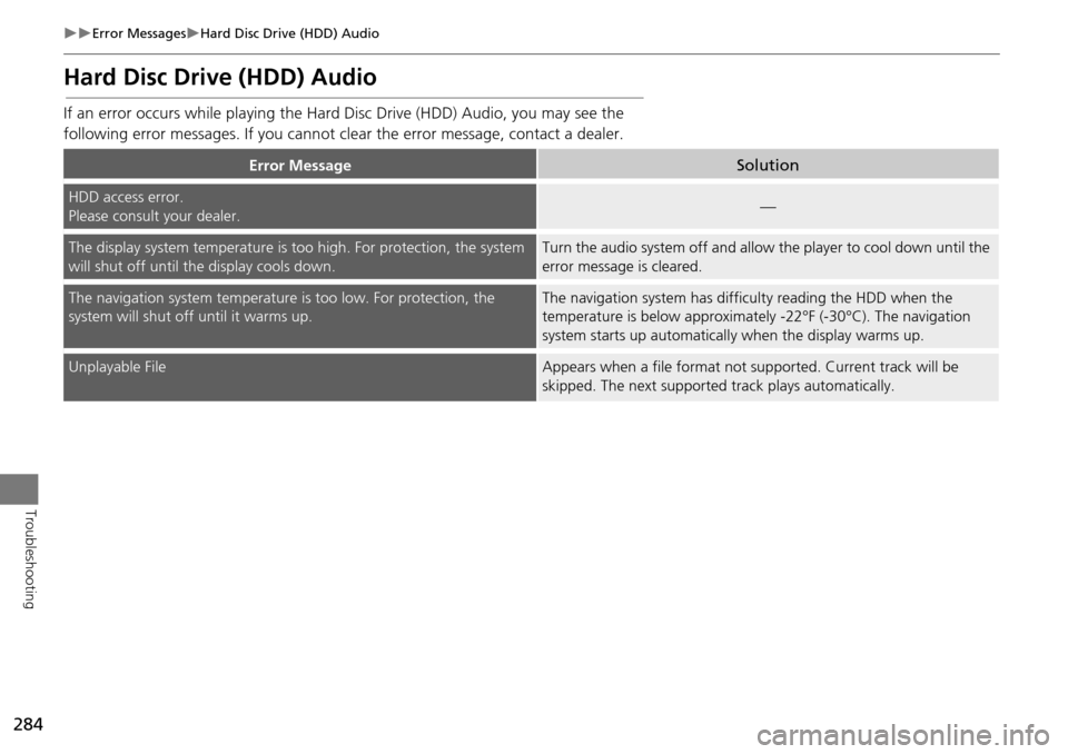
If an error occurs while playing the Hard Disc Drive (HDD) Audio, you may see the
following error messages. If you cannot cl ear the error message, contact a dealer.
Error MessageSolution
HDD access error.
Please consult your dealer.—
The display system temperature is too high. For protection, the system
will shut off until the display cools down.Turn the audio system off and allow the player to cool down until the
error message is cleared.
The navigation system temperature is too low. For protection, the
system will shut o ff until it warms up.The navigation system has difficulty reading the HDD when the
temperature is below approximatel y -22°F (-30°C). The navigation
system starts up automaticall y when the display warms up.
Unplayable FileAppears when a file format not supported. Current track will be
skipped. The next supported track plays automatically.
Page 293 of 325
292
Reference Information
System Limitations
GPS System
The signals received from the GPS satellites
are extremely weak (less than a millionth
of the strength of a local FM station) and
require an unobstructed view of the sky.
The GPS antenna is located in the
dashboard. The signal reception can easily
be interrupted or interfered with by the
following:
• Metallic window tint on the front or side
windows
• Cell phones, PDAs, or other electronic
devices docked in a cradle or lying loose
on the dashboard
• Remote starters or “hidden” vehicle
tracking systems mounted near the
navigation unit
• Audio electronic devices mounted near
the navigation unit
• Trees, tall buildings, freeway overpasses,
tunnels, or overhead electrical power
wires
The GPS is operated by the U.S.
Department of Defense. For security
reasons, there are certain inaccuracies built
into the GPS for wh ich the navigation
system must constantly compensate. This can cause occasional positioning errors of
up to several hundred feet.
Address Calculation
The destination icon shows only the
approximate location of a destination
address. This occurs if the number of
possible addresses is different from the
number of actual addresses on a block. For
example, the address 1425 on a 1400
block with 100 possible addresses
(because it is followed by the 1500 block)
will be shown a quarter of the way down
the block by the system. If there are only
25 actual addresses
on the block, the
actual location of address 1425 would be
at the end of the block.
Database
The digitized map database reflects
conditions as they existed at various points
in time before production. Accordingly,
your database may contain inaccurate or
incomplete data or information due to the
passage of time, road construction,
changing conditions, or other causes.
For example, some places/landmarks may
be missing when you search the database
because the name was misspelled, the
place was improperly categorized, or a
place/landmark is not yet in the database.
This is also true for police stations,
hospitals, and other public institutions. Do
not rely on the navigation system if you
need law enforcement or hospital services.
Always check with local information
sources.
Page 294 of 325
293
System LimitationsDatabase
Reference Information
In addition, the map database contains
verified and unverified areas. Unverified
streets may be missing from the map, in
the wrong location, or have an incorrect
name or address range. A message will
warn you if your route includes unverified
streets. Exercise additional caution when
driving in unve rified areas.
The database does not include, analyze,
process, consider, or reflect any of the
following categories of information:
• Neighborhood quality or safety
• Population density
• Availability or proximity of law
enforcement
• Emergency, rescue, medical, or other
assistance
• Construction work, zones, or hazards
• Road and lane closures
• Legal restrictions (such as vehicular type,
weight, load, height, and speed
restrictions)
• Road slope or grade
• Bridge height, width, weight, or other
limits
• Traffic facilities safety
• Special events •
Pavement characteristics or conditions
Every effort has been made to verify that
the database is accurate. The number of
inaccuracies you experience increases the
longer you go without obtaining an
updated map database.
2 Obtaining a Navigation Update P. 295
We assume no liability for any incident that
may result from an error in the program, or
from changed conditions not noted above.
Page 295 of 325
294
Reference Information
Customer Assistance
Resolving Problems
If you run into a specific issue that you
cannot resolve, consult the following help
resources:
• For navigation system issues:
2 Troubleshooting P. 276
There are also FAQs available online at
www.hondanavi.com.
• For traffic-related issues:
2 Traffic P. 278
• For reporting issues with the database
or places/landmarks:
2 Reporting Errors P. 294
• Call Honda Automobile Customer
Service.
2 Honda Automobile Customer Service
Contact Information
P. 294
Reporting Errors
You can help to improve database
accuracy by reporti ng any errors you
encounter.
• Report errors in freeways and main
“verified” roads shown in black on the
map at http://mapreporter.navteq.com/
dur-web-external/ .
• Please do not report errors in purple
“unverified” roads. Maps for these
areas are provided for reference only.
2 Unverified Routing P. 51
• Please do not report errors in places/
landmarks, such as changes in business
names. Information about points of
interest are constantly being updated.
An updated database is available for
purchase, usually in the fall of each year.
2 Obtaining a Navigation Update P. 295
• For vehicle position ic on errors, screen
error messages, or other GPS-related
errors:
2 Troubleshooting P. 276
2System Limitations P. 292
Honda Automobile
Customer Service Contact
Information
Honda Navi
American Honda Motor Co., Inc.
Honda Automobile Customer Service
Mail Stop 500-2N-7E
1919 Torrance Blvd.
Torrance, CA 90501-2746
Tel: (800) 999-1009
Fax: (310) 783-3273
Visiting a Dealer
If you have a question that you cannot
resolve using the available help resources,
you can consult a dealer. Please identify
the specific is sue (e.g., error occurs when
you enter a specific a ddress, when driving
on a certain road, or just when it’s cold) so
that the service technician can refer the
issue to the factory so that a solution can
be found. Be patient, the service technician
may be unfamiliar with your specific issue.
Page 296 of 325
295
Customer AssistanceMap Coverage
Reference Information
Map Coverage
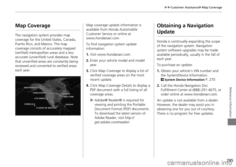
The navigation system provides map
coverage for the United States, Canada,
Puerto Rico, and Mexico. The map
coverage consists of accurately mapped
(verified) metropolitan areas and a less
accurate (unverified) rural database. Note
that unverified areas are constantly being
reviewed and converted to verified areas
each year.
Map coverage update information is
available from Honda Automobile
Customer Service or online at
www.hondanavi.com .
To find navigation system update
information:
1. Visit www.hondanavi.com .
2. Enter your vehicle model and model
year.
3. Click Map Coverage to display a list of
verified coverage areas on the most
recent update.
4. Click Map Coverage Details to display a
PDF document with a full listing of all
coverage areas.
Adobe® Reader® is required for
viewing and printing the Portable
Document Format (PDF) documents.
To download the latest version of
Adobe Reader, visit http://
get.adobe.com/reader/ .
Obtaining a Navigation
Update
Honda is continually expanding the scope
of the navigation system. Navigation
system software upgrades may be made
available periodically, usually in the fall of
each year.
To purchase an update:
1.Obtain your vehicle’s VIN number and
the System/Device Information.
2 System Device Information P. 270
2. Call the Honda Navigation Disc
Fulfillment Center at (888) 291-4675, or
order online at www.hondanavi.com .
An update is not available from a dealer.
However, the dealer may assist you in
obtaining one for you out of courtesy.
There is no program for free updates.
Page 299 of 325
298
Legal InformationUser Agreements
Reference Information
•The terms and conditions hereof apply
to all subsequent users and owners as
well as to the original purchaser.
• The logos of oil companies, hotels,
convenience stores, and other
businesses are displayed for your
information and convenience, and in no
way imply any sponsorship, approval or
endorsement of these companies, or
their products. The logos are trademarks
of their respective owners.
• The marks of companies displayed by
this product to indicate business
locations are the marks of their
respective owners.
• The use of such marks in this product
does not imply any sponsorship,
approval, or endo rsement by such
companies of this product.
The user shall indemnify and save harmless
the Licensors, and their officers, employees
and agents, from and against any claim,
demand or action, irrespective of the
nature of the cause of the claim, demand
or action, alleging loss, costs, expense,
damages or injuries (including injuries
resulting in death) arising out of the use or
possession of the HDD or software. Use, duplication, or
disclosure of this HDD
by or on behalf of the United States
government is subject to “Restricted
Rights” as set forth at FAR 52.227-14, -19
or DFARS 252.227-7013, as applicable.
Manufacturers are the Licensors, including
HONDA MOTOR CO., LT D., 2-1-1 Minami
Aoyama Minato-Ku Tokyo 107-8556
JAPAN., Alpine Electronics, Inc., 20-1
Yoshima Kogyodanchi, Iwaki, Fukushima
970-1192 JAPAN., NAVTEQ Corporation,
425 W Randolph St. Chicago, IL 60606,
USA.
You have acquired a device (“DEVICE”)
that includes software licensed by Alpine
Electronics, Inc. (collectively “ALPINE”)
from an affiliate of Microsoft Corporation
(collectively “MS”). Those installed
software products of MS origin, as well as
associated media, printed materials, and
“online” or electronic documentation
(“SOFTWARE”) are protected by
international intellectual property laws and
treaties. The SOFTWARE is licensed, not
sold. All righ ts reserved.
■Navigation System END USER
LICENSE AGREEMENT
IF YOU DO NOT AGREE TO THIS END USER
LICENSE AGREEMENT (“EULA”), DO NOT
USE THE DEVICE OR COPY THE SOFTWARE
INSTEAD, PROMPTLY CONTACT ALPINE
FOR INSTRUCTIONS ON RETURN OF THE
UNUSED DEVICE(S) FOR A REFUND. ANY
USE OF THE SOFTWARE, INCLUDING BUT
NOT LIMITED TO USE ON THE DEVICE,
WILL CONSTITUTE YOUR AGREEMENT TO
THIS EULA (OR RATIFICATION OF ANY
PREVIOUS CONSENT).
• GRANT OF SOFTWARE LICENSE
This EULA grants you the following
license: You may use the SOFTWARE
only on the DEVICE.
• NOT FAULT TOLERANT
THE SOFTWARE IS NOT FAULT
TOLERANT. ALPINE HAS
INDEPENDENTLY DETERMINED HOW TO
USE THE SOFTWARE IN THE DEVICE,
AND MS HAS RELIED UPON ALPINE TO
CONDUCT SUFFICIENT TESTING TO
DETERMINE THAT THE SOFTWARE IS
SUITABLE FOR SUCH USE.
• NO WARRANTIES FOR THE SOFTWARE
THE SOFTWARE is provided “AS IS” and
with all faults. THE ENTIRE RISK AS TO
SATISFACTORY QUALITY,
PERFORMANCE, ACCURACY, AND
Page 301 of 325
300
Legal InformationUser Agreements
Reference Information
•UPGRADES
If the SOFTWARE is provided by ALPINE
separate from the DEVICE on separate
media or via web download or other
means, and is labeled “For Upgrade
Purposes Only” you may install one (1)
copy of such SOFTWARE onto the
DEVICE as a replacement copy for the
existing SOFTWARE, and use it in
accordance with this EULA, including
any additional EULA terms
accompanying the upgrade SOFTWARE.
• TERMINATION
Without prejudice to any other rights,
ALPINE or MS may terminate this EULA
if you fail to comply with the terms and
conditions of this EULA. In such event,
you must destroy all copies of the
SOFTWARE and all of its component
parts.
• INTELLECTUAL PROPERTY RIGHTS
All title and intellec tual property rights
in and to the SOFTWARE (including but
not limited to any images, photographs,
animations, video, audio, music, text
and “applets,” incorporated into the
SOFTWARE), the accompanying printed
materials, and any copies of the
SOFTWARE, are owned by MS,
Microsoft Corporation, their affiliates or suppliers. The SOFTWARE is licensed,
not sold.
You may not copy the printed materials
accompanying the SOFTWARE. All title
and intellectual prope
rty rights in and to
the content which may be accessed
through use of the SOFTWARE is the
property of the respective content
owner and may be protected by
applicable copyright or other intellectual
property laws and treaties. This EULA
grants you no rights to use such
content. All rights not specifically
granted under this EULA are reserved by
MS, Microsoft Corporation, their
affiliates and suppliers. Use of any on-
line services which may be accessed
through the SOFTWARE may be
governed by the respective terms of use
relating to such services. If this
SOFTWARE contains documentation
that is provided only in electronic form,
you may print one copy of such
electronic documentation.
• TRADEMARKS
This EULA does not grant you any rights
in connection with any trademarks or
service marks of ALPINE MS, Microsoft
Corporation, their affiliates or suppliers. •
PRODUCT SUPPORT
Product support for the SOFTWARE is
not provided by MS, its parent
corporation Microsoft Corporation, or
their affiliates or subsidiaries. For
product support, please refer to ALPINE
support number provided in the
documentation for the DEVICE.
Should you have any questions
concerning this EULA, or if you desire to
contact ALPINE for any other reason,
please refer to the address provided in
the documentation for the DEVICE.
• SOFTWARE TRANSFER ALLOWED BUT
WITH RESTRICTIONS
You may permanently transfer rights
under this EULA only as part of a
permanent sale or transfer of the
Device, and only if the recipient agrees
to this EULA. If the SOFTWARE is an
upgrade, any transfer must also include
all prior versions of the SOFTWARE.
• EXPORT RESTRICTIONS
You acknowledge that SOFTWARE is of
US-origin. You agree to comply with all
applicable international and national
laws that apply to the SOFTWARE,
including the U.S. Ex port Administration
Regulations, as well as end-user, end-
use and country destination restrictions