HONDA PILOT 2021 Navigation Manual (in English)
Manufacturer: HONDA, Model Year: 2021, Model line: PILOT, Model: HONDA PILOT 2021Pages: 127, PDF Size: 4.92 MB
Page 101 of 127
99
Troubleshooting
Troubleshooting................................... 100
Map, Voice, Entering Destinations ........ 100
Traffic .................................................. 101
Guidance, Routing ............................... 102
Update, Coverage, Map Errors ............. 103
Display, Accessories.............................. 103
Miscellaneous Questions ...................... 104
19 PILOT NAVI-31TG78300.book 99 ページ 2018年5月24日 木曜日 午前10時52分
Page 102 of 127
100
Troubleshooting
Troubleshooting
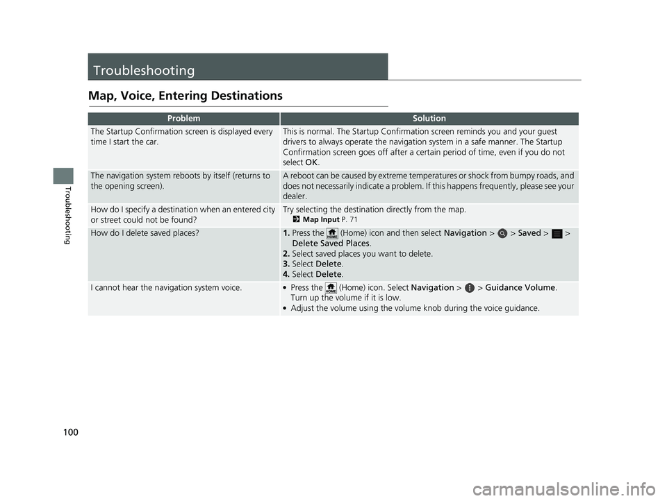
Map, Voice, Entering Destinations
ProblemSolution
The Startup Confirmation screen is displayed every
time I start the car.This is normal. The Startup Confirmation screen reminds you and your guest
drivers to always operate the navigation system in a safe manner. The Startup
Confirmation screen goes off after a certa in period of time, even if you do not
select OK.
The navigation system reboots by itself (returns to
the opening screen).A reboot can be caused by extreme temper atures or shock from bumpy roads, and
does not necessarily indicate a problem. If this happens frequently, please see your
dealer.
How do I specify a destinat ion when an entered city
or street could not be found?Try selecting the destination directly from the map.
2 Map Input P. 71
How do I delete saved places?1.Press the (Home) icon and then select Navigation > > Saved > >
Delete Sa ved Places .
2. Select saved places you want to delete.
3. Select Delete .
4. Select Delete .
I cannot hear the navigation system voice.●Press the (Home) icon. Select Navigation > > Guidance Volume .
Turn up the volume if it is low.
●Adjust the volume using the volume knob during the voice guidance.
19 PILOT NAVI-31TG78300.book 100 ページ 2018年5月24日 木曜日 午前10時52分
Page 103 of 127
101
uuTroubleshooting uTraffic
Troubleshooting
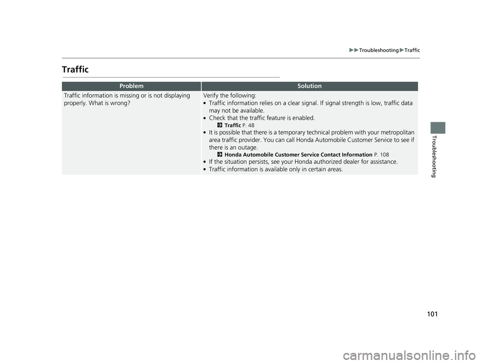
Traffic
ProblemSolution
Traffic information is missing or is not displaying
properly. What is wrong?Verify the following:●Traffic information relies on a clear signal. If signal strength is low, traffic data
may not be available.
●Check that the traffic feature is enabled.
2 Traffic P. 48●It is possible that there is a temporary technical problem with your metropolitan
area traffic provider. You can call Honda Automobile Customer Service to see if
there is an outage.
2 Honda Automobile Customer Service Contact Information P. 108●If the situation persists, see your Honda authorized dealer for assistance.●Traffic information is available only in certain areas.
19 PILOT NAVI-31TG78300.book 101 ページ 2018年5月24日 木曜日 午前10時52分
Page 104 of 127
102
uuTroubleshooting uGuidance, Routing
Troubleshooting
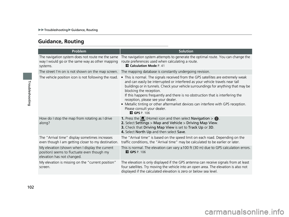
Guidance, Routing
ProblemSolution
The navigation system does not route me the same
way I would go or the same way as other mapping
systems.The navigation system attempts to generate the optimal route. You can change the
route preferences used when calculating a route.
2 Calculation Mode P. 41
The street I’m on is not shown on the map screen.The mapping database is constantly undergoing revision.
The vehicle position icon is not following the road. ●This is normal. The signals received fro m the GPS satellites are extremely weak
and can easily be interrupted or interfe red as your vehicle travels near tall
buildings or in tunnels. Check your vehicle surroundings for anything that may be
blocking the reception.
If this happens frequently and there is no obstruction that is interfering the
reception, please see your dealer.
●Metallic tinting or other aftermarket devices can interfere with GPS reception.
Please consult your dealer.
2 GPS P. 106
How do I stop the map from rotating as I drive
along?1.Press the (Home) icon and then select Navigation > .
2. Select Settings > Map and Vehicle > Driving Map View.
3. Check that Driving Map View is set to Track Up or 3D.
4. Select North Up and then select Save.
The “Arrival time” displa y sometimes increases
even though I am getting closer to my destination.The “Arrival time” is based on the spee d limit on each road. Depending on the
traffic conditions, the “Arrival time” may be calculated to be earlier or later.
My elevation (shown when I display the current
position) seems to fluc tuate even though my
elevation has not changed.This is normal. The elevation can vary ±100 ft (30 m) due to GPS calculation errors.
2 GPS P. 106
My elevation is missing on the “current position”
screen.The elevation is only displayed if the GP S antenna can receive signals from at least
four satellites. Try moving the vehicle into an open area. The elevation is also not
displayed if the calculated elevation is zero or below sea level.
19 PILOT NAVI-31TG78300.book 102 ページ 2018年5月24日 木曜日 午前10時52分
Page 105 of 127
103
uuTroubleshooting uUpdate, Coverage, Map Errors
Troubleshooting
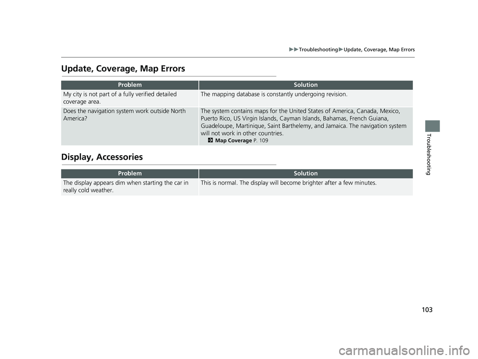
Update, Coverage, Map Errors
Display, Accessories
ProblemSolution
My city is not part of a fully verified detailed
coverage area.The mapping database is constantly undergoing revision.
Does the navigation syst em work outside North
America?The system contains maps for the United States of America, Canada, Mexico,
Puerto Rico, US Virgin Islands, Caym an Islands, Bahamas, French Guiana,
Guadeloupe, Martinique, Saint Barthelemy, and Jamaica. The navigation system
will not work in other countries.
2 Map Coverage P. 109
ProblemSolution
The display appears dim when starting the car in
really cold weather.This is normal. The display will become brighter after a few minutes.
19 PILOT NAVI-31TG78300.book 103 ページ 2018年5月24日 木曜日 午前10時52分
Page 106 of 127
104
uuTroubleshooting uMiscellaneous Questions
Troubleshooting
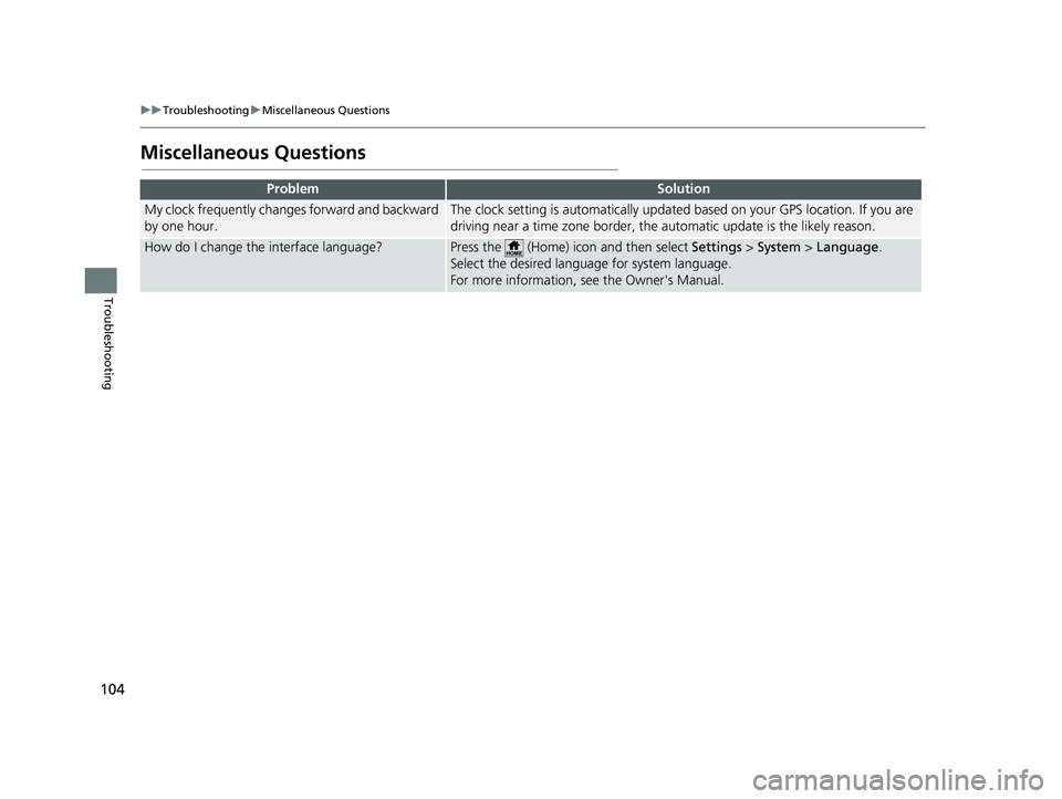
Miscellaneous Questions
ProblemSolution
My clock frequently changes forward and backward
by one hour.The clock setting is automatically updated based on your GPS location. If you are
driving near a time zone border, the automatic update is the likely reason.
How do I change the interface language?Press the (Home) icon and then select Settings > System > Language .
Select the desired language for system language.
For more information, see the Owner's Manual.
19 PILOT NAVI-31TG78300.book 104 ページ 2018年5月24日 木曜日 午前10時52分
Page 107 of 127
105
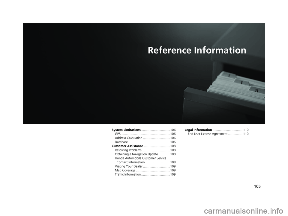
Reference Information
System Limitations................................106
GPS ......................................................106
Address Calculation ..............................106
Database ..............................................106
Customer Assistance .............................108
Resolving Problems ...............................108
Obtaining a Navigation Update .............108
Honda Automobile Customer Service Contact Information ............................108
Visiting Your Dealer ..............................109
Map Coverage ......................................109
Traffic Information ................................109 Legal Information
................................. 110
End User License Agreement ................ 110
19 PILOT NAVI-31TG78300.book 105 ページ 2018年5月24日 木曜日 午前10時52分
Page 108 of 127
106
Reference Information
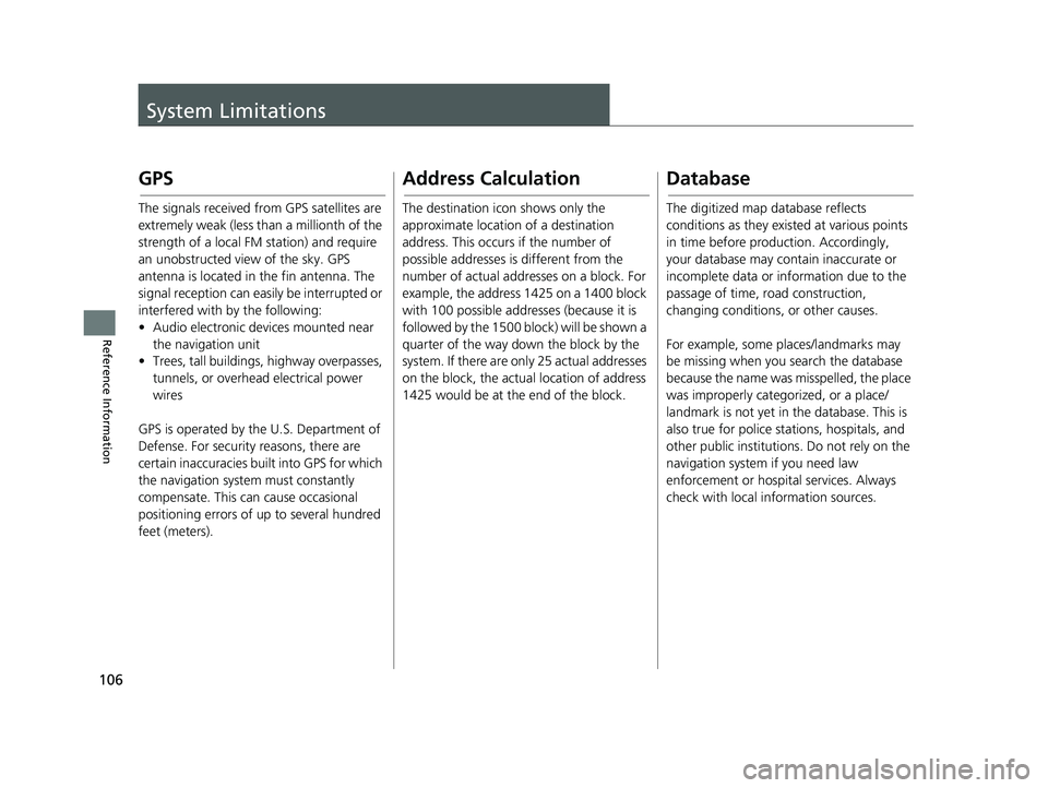
System Limitations
GPS
The signals received from GPS satellites are
extremely weak (less than a millionth of the
strength of a local FM station) and require
an unobstructed view of the sky. GPS
antenna is located in the fin antenna. The
signal reception can easily be interrupted or
interfered with by the following:
• Audio electronic devices mounted near the navigation unit
• Trees, tall buildings, highway overpasses,
tunnels, or overhead electrical power
wires
GPS is operated by the U.S. Department of
Defense. For security reasons, there are
certain inaccuracies bu ilt into GPS for which
the navigation system must constantly
compensate. This can cause occasional
positioning errors of up to several hundred
feet (meters).
Address Calculation
The destination icon shows only the
approximate location of a destination
address. This occurs if the number of
possible addresses is different from the
number of actual addr esses on a block. For
example, the address 1425 on a 1400 block
with 100 possible addresses (because it is
followed by the 1500 block) will be shown a
quarter of the way down the block by the
system. If there are only 25 actual addresses
on the block, the actual location of address
1425 would be at the end of the block.
Database
The digitized map database reflects
conditions as they existed at various points
in time before production. Accordingly,
your database may contain inaccurate or
incomplete data or information due to the
passage of time, road construction,
changing conditions, or other causes.
For example, some places/landmarks may
be missing when you search the database
because the name was misspelled, the place
was improperly categorized, or a place/
landmark is not yet in the database. This is
also true for police stations, hospitals, and
other public institutions. Do not rely on the
navigation system if you need law
enforcement or hospital services. Always
check with local information sources.
19 PILOT NAVI-31TG78300.book 106 ページ 2018年5月24日 木曜日 午前10時52分
Page 109 of 127
107
uuSystem Limitations uDatabase
Reference Information
The database does no t include, analyze,
process, consider, or reflect any of the
following categories of information:
• Neighborhood quality or safety
• Population density
• Availability or proximity of law enforcement
• Emergency, rescue, medical, or other assistance
• Construction work, zones, or hazards
• Road and lane closures
• Legal restrictions (such as vehicular type, weight, load, height, and speed
restrictions)
• Road slope or grade
• Bridge height, width, weight, or other
limits
• Traffic facilities safety
• Special events
• Pavement characteristics or conditions Every effort has been made to verify that
the database is accurate. The number of
inaccuracies you expe
rience increases the
longer you go without obtaining an
updated map database.
2 Obtaining a Navigation Update P. 108
We assume no liability for any incident that
may result from an error in the program, or
from changed conditions not noted above.
19 PILOT NAVI-31TG78300.book 107 ページ 2018年5月24日 木曜日 午前10時52分
Page 110 of 127
108
Reference Information
Customer Assistance
Resolving Problems
If you run into a specific issue that you
cannot resolve, consult the following help
resources:
• For navigation system issues:
2Troubleshooting P. 100
Or, please contact your dealer.
• For traffic-related issues:
2 Traffic P. 101
• For reporting issues with the database or
places/landmarks:
• Visit
https://my.garmi n.com/mapErrors/
report.faces
• Or call Garmin OEM support directly at (855) 607-2536.
Obtaining a Navigation
Update
Honda is continuously updating the
navigation system and new software is
usually made available on an annual basis.
For information on navigation updates for
your vehicle, please visit:
• U.S.: hondanavi.navigation.com
• Canada: www.honda.ca/owners/honda-
services/navigation
You can also contact your Honda
authorized dealer for further information
regarding the update program available for
your vehicle.
Honda Automobile
Customer Service Contact
Information
Honda Navi
American Honda Motor Co., Inc.
Honda Automobile Customer Service
Mail Stop 100-5E-8A
1919 Torrance Blvd.
Torrance, CA 90501-2746
Tel: (800) 999-1009
Fax: (310) 783-3023
Honda Canada Inc.
Honda Customer Relations
180 Honda Blvd.
Markham, ON
L6C 0H9
Tel: (888)-9-HONDA-9
Hours: 8:00 am to 7:30 pm Mon to Fri (EST)
19 PILOT NAVI-31TG78300.book 108 ページ 2018年5月24日 木曜日 午前10時52分